Chapter 02 : The earth’s relief
Introduction
| Meaning of the earth’s relief The earth’s relief is the appearance of various shapes of land on the earth’s surface. These shapes create different kind of landscape on the earth’s surface. The earth’s relief consists of a distribution of relief features such as mountains, hills, plains, plateaus, basins and valleys. Human activities such as farming, construction and livestock keeping depend on the relief features of a given place. Therefore, it is important for us to understand the relief features so that we can interact with them in a sustainable manner. |
Think
Various features of the earth’s relief you have seen
The earth surface is covered by a hard layer known as land. Land has various shapes that form earth’s relief. In this chapter, you will learn about the meaning of the earth’s relief, the major relief features, and the distribution and importance of such features. The competencies to be developed will enable you to interact well with the relief features in your environment.
Activity 1
1. Observe Figure 1 and identify the relief features:
2. Observe and explain the earth’s relief features found in the environment you live in.
Major relief features
Activity 2
Search for videos on the earth’s major relief features in Tanzania on the Internet. Listen and watch the videos you have found, and then write a summary of your findings.
|
Figure 1: Various earth’s relief features |
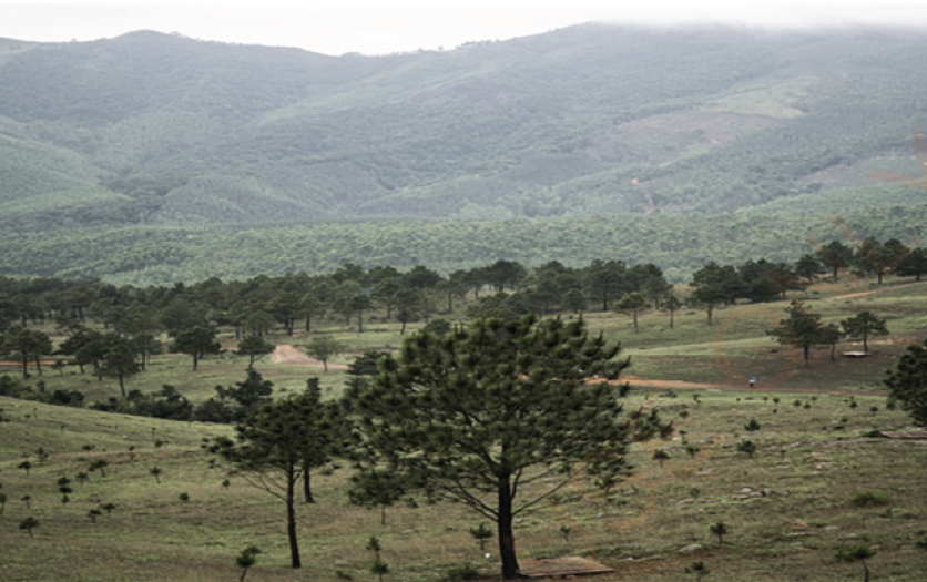
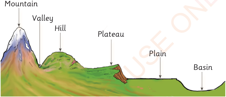
The relief of a place is determined by the presence of various land shapes in the place concerned. The shapes are known as relief features. Relief features vary in appearance in relation to their heights and shapes. In order to understand the differences in land shapes, we need to learn about the earth’s major relief features. Some of the major relief features are mountains, valleys, hills, plateaus, basins and plains. Figure 2 illustrates the major relief features.
|
Figure 2: Major relief features |
Distribution and importance of the earth’s major relief features in Tanzania
Every land has a distinctive shape due to the presence of various earth’s relief features on it. For example, Tanzania’s relief is unique due to its distinctive appearance. The presence of mountains, valleys, plains, hills, basins and plateaus in Tanzania, is country’s pride. These relief features are found in various regions in the country.
Activity 3
Using library or online sources, listen to or read about the distribution of the major relief features in Tanzania. Identify the activities undertaken around the earth’s relief features in Tanzania and in the environment you live.
Mountains
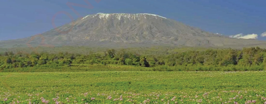
A mountain is a land-form with the highest altitude above the earth’s surface. The top part of a mountain is called a mountain peak or summit. The peak of a mountain may have snow and ice on it or not. In addition, a mountain has steep slopes. Tanzania has several large and small mountains. For example, the highest mountain in Tanzania is Mount Kilimanjaro, which is located in Kilimanjaro Region.
Mount Kilimanjaro has a height of 5,895 meters. The top of Mount Kilimanjaro is covered with ice and snow. This is beacuse, as you go higher, temperature decreases. Mount Kilimanjaro is also the highest mountain in Africa. Figure 3 shows the view of Mount Kilimanjaro.
|
Figure 3: Mount Kilimanjaro |
Some of the other mountains in Tanzania are Mount Meru in Arusha Region with a height of 4,566 metres, and Mount Rungwe in Mbeya Region with a height of 2,981 metres.
The Uluguru Mountains in Morogoro Region with a height of 2,630 metres and the Usambara Mountains in Tanga
Region with a height of 2,290 are also found in Tanzania.
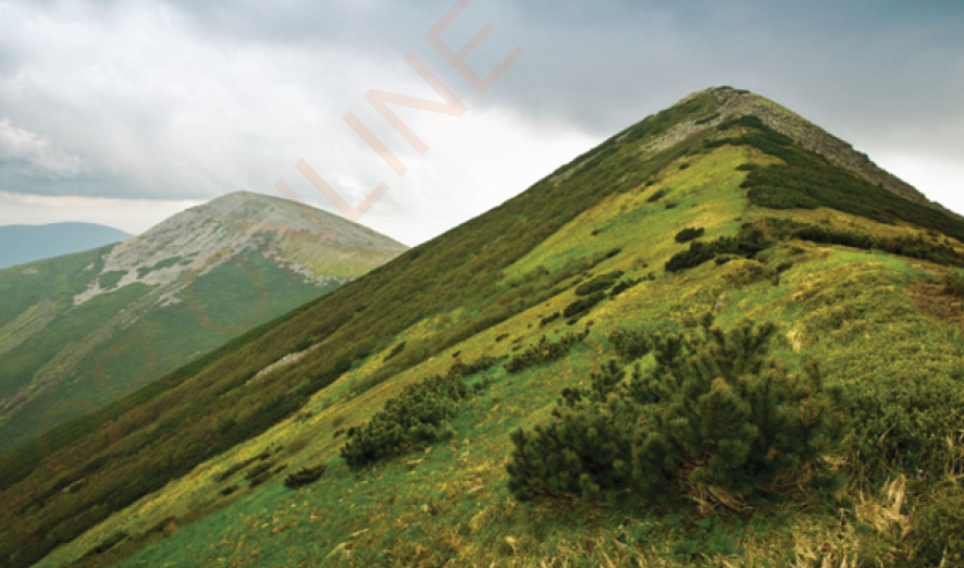
Hills
Hills are landforms that rise to a moderate height. Hills are generally shorter than mountains. Hills do not have steep slopes as mountains do. However, they have peaks as mountains do. Hills are found in various places in Tanzania. Some of the hills in Tanzania are Mererani in Manyara and Ngorongoro in Arusha, Sao and Kitonga in Iringa, and the
Sekenke hills in Singida Region. Figure 4 shows a view of hills.
|
Figure 4: Hills |
Importance of mountains and hills
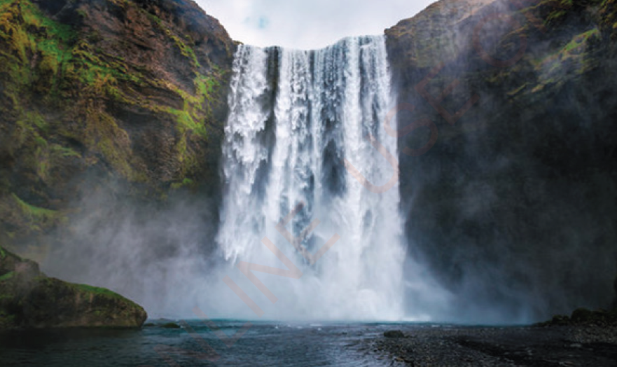
Relief features are essential for human life. Often mountains and hills are a good source of water because they attract rainfall. Water is used by human beings and other organisms for various purposes. Additionally, mountains and hills are tourist attractions. Tourists climb mountains and hills to see forests, waterfalls and various organisms. People engage in tourism-related activities such as pottery-making to earn money. Figure 5 shows a waterfall.
|
Figure 5: A view of a waterfall |
In addition, on the slopes of some mountains there are thick forests with animals, which are tourist attractions. The trees found in forests provide wood and other building materials. Some trees provide medicines which are used by human beings to treat different diseases.
Exercise 1
Choose the letter of the correct answer
1. Which of the following characteristics distinguish a mountain from a hill?
(a) Height and slopes
(b) Height and soil fertility
(c) Rocks and soil
(d) Shortness and the abundance of snow
2. Why are the picks of certain mountains like that of Kilimanjaro are covered with ice?
(a) They are very hot
(b) They receive heavy rainfall
(c) They are very cold
(d) There is much water on them
Short-answer items
3. What challenges do masons face when building houses on hilly or mountainous areas?
4. What environmental impacts would result from farming on mountain slopes?
5. Mention the mountains found in the following regions:
- Arusha
- Mbeya
- Morogoro
Valleys
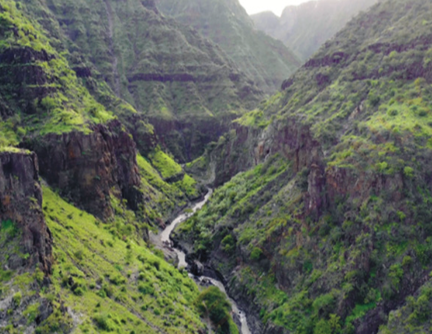
Valleys are areas of lower land which are found between two hills or mountains, as shown in Figure 6.
|
Figure 6: A valley |
Some valleys have rivers flowing through them. Lakes may also form within valleys. For example, Tanzania has a major East African rift valley with several lakes. The lakes in this valley include Lake Natron in Arusha Region and Eyasi and Manyara in Manyara region. Others lakes in the east African rift valley are Lake Tanganyika in Kigoma, Katavi and Rukwa Regions. Lake Tanganyika is the deepest lake in Tanzania and Africa. There are also Lake Nyasa in Ruvuma, Njombe and Mbeya Regions.
The importance of valleys
Valleys are important because they collect water from elevated areas. Thus, valleys are an important source of water. Areas with valleys that contain lakes and rivers are habitats for aquatic organisms such as fish. Therefore, fishing is undertaken in these areas. Some valleys have fertile soil; therefore, they are suitable for irrigation farming. Additionally, the rivers in valleys can be dammed to generate hydro-electric power. Lakes and some rivers are useful for transporting people and goods using vessels such as ships and boats.
Plateaus
A plateau is a large area of flat elevated land that is relatively raised sharply above the surrounding land. Figure 7 shows the view of a plateau.
|
Figure 7: A plateau |
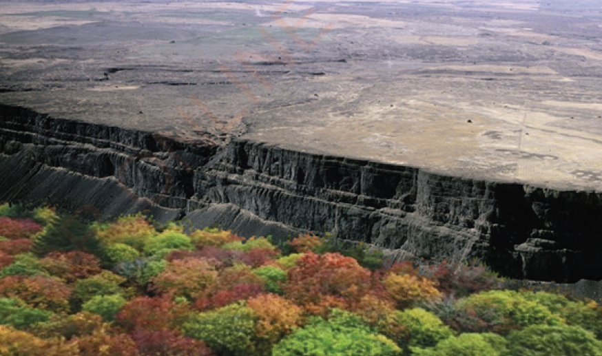
Plateaus vary in shape and size. An example of a plateau in Tanzania is the Southern highland plateau in the regions of Iringa, Mbeya and Njombe.
The importance of plateaus
Some plateaus are used for human settlements and preserved as tourist attractions due to their beautiful outlook and pleasant weather. For example, Kitulo is a national park situated in the Southern highland plateau in Mbeya and Njombe. This park is located between the peaks of Kipengele, Uporoto and Livingstone mountain ranges. This is the first reserve in Africa to be established so as to conserve its natural plants and flowers. Other parts of the plateau are used for agricultural purposes.
Plains
A plain is a landform that is relatively flat. It is unlike a mountain or a hill. A large part of a plain tends to have a fairly uniform elevation as shown in Figure 8. In Tanzania, plains include certain parts of the Serengeti and Tarangire National Parks.
|
Figure 8: A plain |
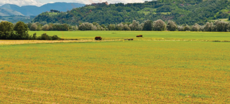
The importance of plains
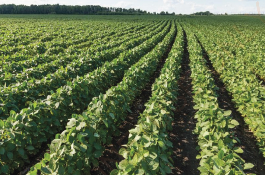
Plains normally have fertile soil that is suitable for farming and livestock grazing. Similarly, plains are also suitable for building houses and other kind of infrastructure because they do not require much levelling. Figure 9 shows farming on a plain.
|
Figure 9: Farming on a plain |
Plains are also good for sports and transport activities. In addition, these areas may have forests that provide habitats for animals and other kinds of organisms which are tourists’ attractions.
Basins
A basin is a bowl-shaped depression on the earth’s surface. Some basins contain water, while others do not. A basin that contains water forms a lake. An example of a basin with water is Lake Victoria which borders Mwanza, Kagera, Mara, Simiyu and Geita regions. Lake Victoria is the largest lake in Tanzania and Africa.
Exercise 2
1. What is the difference between Lake Victoria and Tanganyika?
2. Which regions in Tanzania are found in the Southern highlands plateau?
3. In what type of the earth’s relief feature would you prefer to build your house? Why?
4. What would happen if houses were built near valleys?
Revision exercise
Choose the letter of the correct answer
1. Which of the following earth’s relief features can influence the formation of rain?
(a) Plains
(b) Valleys
(c) Mountains
(d) Basins
2. In which region are the Usambara mountain ranges found?
(a) Kilimanjaro
(b) Morogoro
(c) Tanga
(d) Mbeya
3. Match the items in column A with the corresponding responses in column B
| Column A | Column B |
| (i) Mountains (ii) Valleys (iii) Plains (iv) Hills | A. moderately elevated landforms with round flat peaks B. there are no mountains, hills or any higher elevations C. highly elevated above the earth’s surface D. areas of lower land often deep down between two hills or mountains |
Short-answer items
4. What distinguishes the earth’s relief of a given place?
5. With examples, identify the earth’s major relief features found in the following regions:
- Iringa
- Morogoro
- Mwanza
- Kigoma
- Kilimanjaro
- Singida
6. With specific examples, explain the importance of the earth’s major relief features found in Tanzania.
Vocabulary
Earth’s surface the outer part of the earth that consists of land and water areas
Elevation a raised height than other areas above the sea level
Lake a relatively large body of water that is totally surrounded by land
Tourism a social, cultural and economic phenomenon which entails the movement of people to countries or places outside their usual environment for leisure, business, learning purposes or treatment
www.learninghubtz.co.tz

Hub App
 For Call,Sms&WhatsApp: 255769929722 / 255754805256
For Call,Sms&WhatsApp: 255769929722 / 255754805256  Matokeo KIDATO CHA II 2024
Matokeo Darasa IV 2024
SECONDARY REGIONAL EXAMS
PRIMARY REGIONAL EXAMS
FORM VI NECTA REVIEWS
FORM IV NECTA REVIEWS
FORM II NECTA REVIEWS
STD VII NECTA REVIEWS
STD IV NECTA REVIEWS
SECONDARY EXAMS SERIES
PRIMARY EXAMS SERIES
PRIMARY SUBJECT NOTES
SECONDARY SUBJECT NOTES
SECONDARY TOPICAL EXAMS
SECONDARY TOPICAL QUESTIONS
PRIMARY TOPICAL QUESTIONS
PRACTICAL EXAMS & NOTES
SECONDARY REGIONAL EXAMS
DOWNLOAD SUBJECT NOTES
SCHEMES OF WORK (PRIMARY & SECONDARY)
LESSON PLAN
SECONDARY LOG BOOKS
PRIMARY LOG BOOKS
LITERARY WORKS / UCHAMBUZI VITABU
METHALI ZOTE ZA KISWAHILI
Vitendawili Vya Kiswahili
FORM VI RESULTS 2024
FORM FIVE SELECTION 2024
MATOKEO KIDATO CHA IV 2023
FORM ONE SELECTION 2024
Matokeo Darasa VII 2023
FORM VI RESULTS 2023
Matokeo Darasa IV 2022
Matokeo KIDATO CHA II 2024
Matokeo Darasa IV 2024
SECONDARY REGIONAL EXAMS
PRIMARY REGIONAL EXAMS
FORM VI NECTA REVIEWS
FORM IV NECTA REVIEWS
FORM II NECTA REVIEWS
STD VII NECTA REVIEWS
STD IV NECTA REVIEWS
SECONDARY EXAMS SERIES
PRIMARY EXAMS SERIES
PRIMARY SUBJECT NOTES
SECONDARY SUBJECT NOTES
SECONDARY TOPICAL EXAMS
SECONDARY TOPICAL QUESTIONS
PRIMARY TOPICAL QUESTIONS
PRACTICAL EXAMS & NOTES
SECONDARY REGIONAL EXAMS
DOWNLOAD SUBJECT NOTES
SCHEMES OF WORK (PRIMARY & SECONDARY)
LESSON PLAN
SECONDARY LOG BOOKS
PRIMARY LOG BOOKS
LITERARY WORKS / UCHAMBUZI VITABU
METHALI ZOTE ZA KISWAHILI
Vitendawili Vya Kiswahili
FORM VI RESULTS 2024
FORM FIVE SELECTION 2024
MATOKEO KIDATO CHA IV 2023
FORM ONE SELECTION 2024
Matokeo Darasa VII 2023
FORM VI RESULTS 2023
Matokeo Darasa IV 2022
WHATSAPP US NOW FOR ANY QUERY
App Ya Learning Hub Tanzania


