
FORM TWO GEOGRAPHY EXAM SERIES 221
FORM TWO GEOGRAPHY EXAM SERIES 221
THE PRESIDENT’S OFFICE
REGIONAL ADMINISTRATION AND LOCAL GOVERNMENT
SECONDARY SCHOOL EXAMINATION SERIES
GEOGRAPHY FORM TWO
PRE-NECTA-2025
CODE 012
TIME: 2:30 HOURS
INSTRUCTIONS.
- This paper consists of section A, B and C with the total number of ten(10) questions
- Answer all questions in each section
- Section A carries (15) marks, section B (70) marks and section C carries (15) marks
- All writing must be in blue/black ink except drawing which must be in pencil
- Cellular phones and any unauthorized materials are not allowed in the assessment room.
SECTION A (15 Marks)
Answer all questions in this section
i. The instrument at the weather station which is painted white and is used for storing other weather instruments is known as a
- Barometer
- Wind vane
- Stevenson screen
- Rain gauge.
ii. Lines of longitude measure distances:
(A) North and South from the Equator
(B) East and West from the Prime Meridian
(C) Around the Earth's circumference
(D) From the Earth's surface to its center
iii. A map showing important natural and human made feature is known as
- A topographical map
- A statistical map
- A distribution map
- An atlas map.
iv. Which type of mountains are formed when a movement in the earth’s crust forces the rocks to break and form faults?
- Block Mountains
- Fold Mountains
- Residual Mountains
- Volcanic Mountains.
v. Geography connects to other subjects, like science and history, because:
(A) Many things happen on Earth, which is related to lots of subjects
(B) It's the most important subject
(C) You need maps to study anything
(D) You don't need other subjects
vi. Which one of the following climatic elements is not influenced by temperature?
- Humidity
- Rainfall
- Pressure
- Condensation
vii. An agricultural activity which involves crop production in a small piece of land is called?
- Shift cultivation
- Arable farming
- Subsistence farming
- Sedentary farming
viii. What if timber as used in Geography?
- Is the wood materials derived from the forests.
- Collection of timber products
- Production of forest resources.
- Good management of forest resources.
ix. The production of bulk products like iron, steel, car assembly and ship building is referred to as:-
- Heavy industry
- Simple or light industry
- Secondary industry
- Primary industry
x. Major categories of minerals are:-
- Metals and non – metals
- Reactants and non – reactants.
- Chemicals and non – chemicals
- Organic and inorganic minerals
2. Match the following heavenly bodies in LIST A with their description in LIST B
| LIST A | LIST B |
| A. Large, round celestial body that orbits a star B. A bright streak of light caused by a space rock burning up in the atmosphere C. A celestial body with sufficient mass for self-gravity to hold a spherical shape D. Relatively small object orbiting the Sun, mainly found in the Asteroid Belt E. Icy object with a tail of gas and dust when near the Sun |
3. (a) What is the difference between climate and weather?
(b) What is the importance of climate to human activities.
4. (a) Define the term transport
(b) Name the three major forms of transport
5. (a) List the advantage and disadvantages of sea transport
(b) Name two lakes used for transport purposes in East Africa
6. (a) Name four relief features of the ocean flow
- ………………………………………………………….
- ………………………………………………………….
- ………………………………………………………….
- ………………………………………………………….
(b). Identify two types of ocean Currents
- …………………………………………………………
- …………………………………………………………
7. Discuss problems facing large scale agriculture in Tanzania.
8. Which are the factors influencing mineral exploitation?
9. Point out disadvantages faced by women or girls who walk for a long distance looking for firewood.
SECTION C
10. Mr. Sagutinho is an investor from Brazil who wants to start a manufacturing industry in Tanzania. Which are the factors to consider where to locate his manufacturing industry?
FORM TWO GEOGRAPHY EXAM SERIES 213
FORM TWO GEOGRAPHY EXAM SERIES 213
THE PRESIDENT’S OFFICE
REGIONAL ADMINISTRATION AND LOCAL GOVERNMENT
COMPETENCY BASED EXAMINATIONS
FORM TWO PRE-FTNA ASSESSMENTS
GEOGRAPHY
CODE: 013
TIME: 2:30 Hours October ,2022
INSTRUCTIONS
- This paper consist of section A, B and C
- Answer all question in section A.B and C
- Answer all questions in the space provided
- Cellular phoned, calculators and any computerized materials are not allowed in the examination room.
- All writing must be in blue /black ball pen except drawings which must be in pencil
- Write your examination number at the top right corner of every page
SECTION A (15 marks)
Answerallquestionfromthissection
- For each of the items (i) – (x), choose the correct answer from among the given alternatives and write its letter in the box provided.
- Each planet takes a different amount of time to take one orbit around the sun, because ;
- Their size vary from each other
- Their orbits are elliptical
- They are arranged in series
- Their distance from the sun vary
- The distance between two crest of water wave is referred tom
- Anticline
- Syncline
- Trough
- Wavelength
- Pastoralism where animal are given feeds in sheds without making them to go out in the field is known as;
- Zero grazing
- Nomadic pastoralism
- Mixed pastoralism
- Ranching
- The temperature at Moshi 950m is 24oC .What will be the temperature at Uhuru Peak 5895m above the sea level?
- 5.67oC
- −8oC
- −24oC
- 18oC
- Which one of the following instrument is not the component of a weather station?
- Rain gauge
- Wind vane
- Microscope
- Stevenson screen
- The time which is recorded along the same meridian is called?
- Local mean time
- Greenwich mean time
- Great mean time
- Standard time
- Which scale is the largest among the following;
A. 1:25,000
B. 1:1,1500,000
C. 1:50,000
D. 1:10,000
- A someone ascends in altitude ,the temperature tends to;
- Decrease and increase
in time
- Decrease at the rate of 0.6
FORM TWO GEOGRAPHY EXAM SERIES 130
FORM TWO GEOGRAPHY EXAM SERIES 130
THE PRESIDENT�S OFFICE
MINISTRY OF EDUCATION, REGIONAL ADMINISTRATION AND LOCAL GOVERNMENT
COMPETENCE BASED �SECONDARY EXAMINATION SERIES
ANNUAL �EXAMINATION
FORM TWO
� � � � GEOGRAPHY
� � � �013 � � � � � � � � � � � � � � � � � � � � � � � �
TIME: 2:30 HOURS � � � � � � � � � � � � � � � � � � � � � � � � � � � � November, 2021
![]()
Instructions
1.This paper consists of sections A, B and C.
2.Answer all questions from sections A and B and any two (2) questions from section C.
3.Section A carries twenty five (25) marks, section B forty five (45) marks and section C carries thirty (30) marks.
4.All answers must be written in the spaces provided.
5.All writings must be in blue or black ink except for drawings which must be in pencil.
6.All communication devices, calculators and any unauthorized materials are not allowed in the Examination Room.�
7.Write Your Examination Number on the top right of every page.
| FOR EXAMINER�S USE ONLY | ||
| QUESTION NUMBER | SCORE | EXAMINER�S INITIALS |
| 1 | ||
| 2 | ||
| 3 | ||
| 4 | ||
| 5 | ||
| 6 | ||
| 7 | ||
| 8 | ||
| 9 | ||
| 10 | ||
| TOTAL� | ||
| CHECKER�S INITIALS | ||
SECTION A: (25 Marks)
Answer all questions in this section
1.Each of the items (i) - (x), choose the correct answer from the given alternatives and write its letter in the space provided.
(i)Branch of Geography dealing with field study, statistics, mapping and surveying is called:
A.Physical geography
B.Human and economic geography
C.Practical geography�
D. Environmental geography.
(ii)When the Earth is at its aphelion in early July, the distance from the sun is about:
A.500,000,000 km
B.5,500,000 km
C.4,800,00 km�
D. 1,500,000 km.
(iii)The amount of humidity existed in air is measured by instrument called:
A.Barometer
B.Hygrometer
C.Hydrometer
D.Agrometer.
(iv)In temperature regions of the world life in mountain and plateau areas is difficult due to:
A.There is high temperature throughout the year
B.There is thin soils, cool climate and difficult and communication
C.There is heavy wild animals and high rainfall D.There is no efficient power and water supply.
(v)The map of school compound or small village is drawn to:
A.Large scale
B.Small scale
C.Medium scale
D.Secondary section of the scale.
(vi)Quarrying, hunting, fishing and lumbering is referred to:
A.Secondary activities
B.Tertiary activities
C.Quaternary activities
D.Primary activities.
(vii)In Africa most farmers leave idle the exhausted piece of land for a certain period of time in order to regain its fertility, this agricultural technique is called:
A.Bush fallowing
B.Shifting cultivation�
C. Sedentary farming
D. Aquaculture.
(viii)Africa has potential river development projects which are multipurpose schemes, since they provide irrigation schemes, flood control, water supply in both industries and domestic and Hydro Electrical power generation centres.The following are prominent H.E.P centres of East Africa, except:
A.Kihansi and Owen falls
B.Nyumba ya Mungu and Inga dams
C.Hale and Mtera dams
D.Kidatu and Seven forks in Tana river
(ix)Which sequence of the following processes is necessary for the formation of rainfall?
A.Condensation, cooling and evaporation
B.Evaporation, cooling and condensation
C.Evaporation, sedimentation and cooling
D.Evaporation, condensation and cooling.
(x)What is compass bearing of WNW?
A.270o�
B. 337o�
C. 315o
D. 327o
2.Match each item in LIST A with responses in LIST B by writing the letter of the correct response below the corresponding item number in the table provided:
| LIST A | LIST B |
| (i)Are continuous stretches of comparatively flatland not rising much above sea level� (ii)Is a major landmass rising from the ocean floor (iii)Extensive high altitude areas with more or less uniform summit levels� (iv)Is a form of natural or artificial depression or hollow varying in size on the Earth�s surface. (v)Long narrow depression or trough in the central part formed between two parallel faults | A.Continent B.Mountain C.Basin D.Crater E.Plains F.Rift valley� G.Plateau |
Answers:
| LIST A | (i) | (ii) | (iii) | (iv) | (v) |
| LIST B |
3.In each of the following items (i) � (x), write True if the statement is correct or False if the statement is not correct.
(i)All meridians and the equator form great circle. ____________________________
(ii)Ranching is a practice of rearing livestock with the aim of not producing meat, milk, wool and hides for commercial purposes. �____________________________
(iii)The moon appears to rise in the East and set in the West because the earth spins from West to East. � � � � �_________________________
(iv)Sea Breeze occurs during the day because sea water creates high pressure region in contrast to the land which develops low pressure during the day time. � �_________
(v)Large scale livestock farming is also known as zero grazing. � _________________ � �
(vi)A map showing distribution of natural and manmade features is known as topographical map. � � � � � � � �________________
(vii)Exploitation of natural gases in Tanzania is only done by public companies. � � � � � �
�(viii) The desert conditions are characterized by scanty vegetation and rainfall. ��
� � _________________
(ix)Air transport is not affected by adverse weather conditions. � � _________________
(x)The flow of water over the ground is known as run-off. � � � � � _________________
SECTION B: (45 Marks)
Answer all questions in this section
4.(a) ��Geography� can be defined as the study of the distribution and interrelationship of �phenomena in relation to the earth�s surface. Briefly explain how geography relates � �with:
(i) �Biology
_____________________________________________________________________
_____________________________________________________________________ _____________________________________________________________________ _____________________________________________________________________
_____________________________________________________________________
_____________________________________________________________________
4.(ii) �Commerce
_____________________________________________________________________
_____________________________________________________________________
_____________________________________________________________________ _____________________________________________________________________
_____________________________________________________________________
� � (b) Explain the economic importance of studying geography:
(i)_______________________________________________________________
� � � � � � � � � � � � �_______________________________________________________________
(ii)_______________________________________________________________
� � � � � � � � � � � � �_______________________________________________________________
(iii)_______________________________________________________________
� � � � � � � � � � � � � �______________________________________________________________
(iv)______________________________________________________________
(v)______________________________________________________________
� � � � � � � � � � � � � �______________________________________________________________
5.Carefully study the climatic characteristics of station X and answer the equations that � � � follow:�
Climatic characteristics:
�Annual range of temperature is very small about 2oC.
�Total rainfall ranges form 1500mm to 3,000mm per year with no distinct dry season.
�The type of rainfall is convectional rainfall accompanied by lightening and thunderstorms.
�High humidity through the year.�
QUESTIONS:
(i) � Identify the type of climate in station X. ____________________________�
(ii) � List any three (3) crops which can be grown in station X.
(a)________________________________________________________
(b)________________________________________________________
(c)________________________________________________________
5.(iii) � � In which part of Africa this climate is found?
(a)___________________________________________________________
(b)__________________________________________________________ � � ��
�(iv) � � Mention two (2) main economic activities taking place in this station:
(a)______________________________________________________________
(b)______________________________________________________________
6.Study carefully sketch map of MAFIGA provided and answer the questions that follow: �
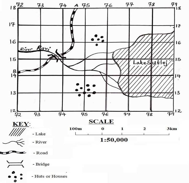
MAP OF MAFIGA:
6. � � � � �(a) � � � �Calculate are covered by Lake Sutlej in kilometer square
_______________________________________________________________
_______________________________________________________________
_______________________________________________________________
_______________________________________________________________
(b)Measure the length of road from point A to point B. (Answer in km)
_______________________________________________________________
_______________________________________________________________
_______________________________________________________________ _______________________________________________________________
_______________________________________________________________
(c)Mention two (2) economic importance of the feature found eastern side of the � � �map:
(i)________________________________________________________
(ii)______________________________________________________________
(d)Identify the feature found at grid reference 750130:
� � � � � � � � � � � � � � The feature is
_______________________________________________________________
_______________________________________________________________
(e)Name two (2) man made features shown on a map.
(i)________________________________________________________
(ii)________________________________________________________
SECTION C: (30 Marks)
Answer two (2) questions in this section
7.The types of human activities are always related to the type of settlement. Elaborate four
(4) importance of human activities.
8.Explain why electricity is preferable source of power than fuel wood (Give five points)
9.Suggest any four (4) ways in which the tourism sector can be used to generate more income in Tanzania.
10.Outline five (5) ways of reducing industrial pollution in the world.
___________________________________________________________________________ _16px;">___________________________________________________________________________
FORM TWO GEOGRAPHY EXAM SERIES 76
FORM TWO GEOGRAPHY EXAM SERIES 76

DOWNLOAD LEARNING HUB APP NOW

SORRY, YOU CAN'T VIEW THIS MARKING SCHEME PLEASE DOWNLOAD LEARNING HUB APP FROM PLAYSTORE TO GET FULL ACCESS TO ALL MARKING SCHEME!!
Click Here To Download Learning Hub Tanzania App
SAMAHANI, HUWEZI KUFUNGUA MAJIBU YA MTIHANI, TAFADHALI PAKUA APP YA LEARNING HUB TANZANIA ILI KUWEZA KUFUNGUA MAJIBU YA MITIHANI KATIKA TOVUTI HII!!
Bofya Hapa Kupakua App Ya Learning Hub Tanzania
Hub App
 For Call,Sms&WhatsApp: 255769929722 / 255754805256
For Call,Sms&WhatsApp: 255769929722 / 255754805256  Matokeo Darasa VII 2025
Matokeo KIDATO CHA II 2024
Matokeo Darasa IV 2024
SECONDARY REGIONAL EXAMS
PRIMARY REGIONAL EXAMS
FORM VI NECTA REVIEWS
FORM IV NECTA REVIEWS
FORM II NECTA REVIEWS
STD VII NECTA REVIEWS
STD IV NECTA REVIEWS
SECONDARY EXAMS SERIES
PRIMARY EXAMS SERIES
PRIMARY SUBJECT NOTES
SECONDARY SUBJECT NOTES
SECONDARY TOPICAL EXAMS
SECONDARY TOPICAL QUESTIONS
PRIMARY TOPICAL QUESTIONS
PRACTICAL EXAMS & NOTES
SECONDARY REGIONAL EXAMS
DOWNLOAD SUBJECT NOTES
SCHEMES OF WORK (PRIMARY & SECONDARY)
LESSON PLAN
SECONDARY LOG BOOKS
PRIMARY LOG BOOKS
LITERARY WORKS / UCHAMBUZI VITABU
METHALI ZOTE ZA KISWAHILI
Vitendawili Vya Kiswahili
FORM VI RESULTS 2024
FORM FIVE SELECTION 2024
MATOKEO KIDATO CHA IV 2023
FORM ONE SELECTION 2024
FORM VI RESULTS 2023
Matokeo Darasa IV 2022
Matokeo Darasa VII 2025
Matokeo KIDATO CHA II 2024
Matokeo Darasa IV 2024
SECONDARY REGIONAL EXAMS
PRIMARY REGIONAL EXAMS
FORM VI NECTA REVIEWS
FORM IV NECTA REVIEWS
FORM II NECTA REVIEWS
STD VII NECTA REVIEWS
STD IV NECTA REVIEWS
SECONDARY EXAMS SERIES
PRIMARY EXAMS SERIES
PRIMARY SUBJECT NOTES
SECONDARY SUBJECT NOTES
SECONDARY TOPICAL EXAMS
SECONDARY TOPICAL QUESTIONS
PRIMARY TOPICAL QUESTIONS
PRACTICAL EXAMS & NOTES
SECONDARY REGIONAL EXAMS
DOWNLOAD SUBJECT NOTES
SCHEMES OF WORK (PRIMARY & SECONDARY)
LESSON PLAN
SECONDARY LOG BOOKS
PRIMARY LOG BOOKS
LITERARY WORKS / UCHAMBUZI VITABU
METHALI ZOTE ZA KISWAHILI
Vitendawili Vya Kiswahili
FORM VI RESULTS 2024
FORM FIVE SELECTION 2024
MATOKEO KIDATO CHA IV 2023
FORM ONE SELECTION 2024
FORM VI RESULTS 2023
Matokeo Darasa IV 2022


