
LEARNINGHUBTZ.CO.TZGEOGRAPHY STANDARD FOUR EXAM SERIES 118
LEARNINGHUBTZ.CO.TZGEOGRAPHY STANDARD FOUR EXAM SERIES 117
LEARNINGHUBTZ.CO.TZGEOGRAPHY STANDARD FOUR EXAM SERIES 116
OFFICE OF THE PRESIDENT, REGIONAL ADMINISTRATION AND LOCAL GOVERNMENT
PRIMARY EXAMINATION SERIES
MARCH 2025
STANDARD FOUR, GEOGRAPHY AND ENVIRONMENT
- MULTIPLE CHOICES
- What does the study of geography deal with?
(A)relief features and settlements only
(B) human activities and physical features
(C) water bodies and plants only
(D) everything on the land
- Juma lives near lake Victoria which economic activity is he likely to practise
(A) agriculture
(B) lumbering
(C) fishing
(D) mining
- The following are feature we study on the earth except
(A) atmosphere
(B) land
(C) water bodies
(D) history
iv. Moses lives in Mafinga Iringa, where there is a dense forests. Which economic activity is he likely to practice
(A) fishing
(B) lumbering
(C) mining
(D) construction
v. The following are branches of Geography except
(A) photography interpretation geography
(B) human geography
(C) physical Geography
(D) practical geography
vi. Which of the following refers to the atmospheric condition experienced over a short period, it many be an hour
(A) weather
(B) resources
(C) disaster
(D) climate
vii. The process of cutting down trees for charcoal, timber is called
(A) afforestation
(B)re- a forestation
(C) deforestation
(D) air pollution
viii. Mr. John works in a timber processing factory. So Mr john experiences
(A) air pollution
(B) noise pollution
(C) water pollution
(D) land pollution
ix. The following are sources of water sources except
(A)river
(B) lake
(C) building
(D) dam
x. People who travel to places of interest for study or leisure are called
(A) traders
(B) students
(C) drivers
(D) tourist
xi. Which of the following is physical features
(A) mountain
(B) mountain
(C) river
(D) lake
xii. Among the following is a man- made feature .
(A) darn
(B) lake
(C) valley
(D) river
xiii. The tallest mountain in Tanzania is called
(A) Mt. Meru
(B) Mt. Oldonyo Lengai
(C) Mt. Kilimanjaro
(D) Mt. Uluguru
xiv. Human residences in towns and cities are called settlements
(A) village
(B) urban
(C) commercial
(D) rural
xv. The extraction of minerals from the under ground is called
(A) fishing
(B) mining
(C) lumbering
(D) agriculture
SECTION B:
4. MATCHING ITEMS
| LIST A | ANSWER | LIST B |
|
| A. Compass directions |
|
| B. Frame |
|
| C. Key |
|
| D. Title |
|
| E. Scale |
|
|
|
|
SECTION C:
STRUCTURE
5. i. What is the meaning of direction?
ii. Define re-afforestation
Use the compass direction below to answer questions
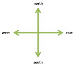
- Which direction does the sun set
- Which direction is Mt Kilimanjaro from our school Patrick Primary school
- Which direction does the sun rise
LEARNINGHUBTZ.CO.TZGEOGRAPHY STANDARD FOUR EXAM SERIES 111

DOWNLOAD LEARNING HUB APP NOW

SORRY, YOU CAN'T VIEW THIS MARKING SCHEME PLEASE DOWNLOAD LEARNING HUB APP FROM PLAYSTORE TO GET FULL ACCESS TO ALL MARKING SCHEME!!
Click Here To Download Learning Hub Tanzania App
SAMAHANI, HUWEZI KUFUNGUA MAJIBU YA MTIHANI, TAFADHALI PAKUA APP YA LEARNING HUB TANZANIA ILI KUWEZA KUFUNGUA MAJIBU YA MITIHANI KATIKA TOVUTI HII!!
Bofya Hapa Kupakua App Ya Learning Hub Tanzania
Hub App
 For Call,Sms&WhatsApp: 255769929722 / 255754805256
For Call,Sms&WhatsApp: 255769929722 / 255754805256  Matokeo Darasa VII 2025
Matokeo KIDATO CHA II 2024
Matokeo Darasa IV 2024
SECONDARY REGIONAL EXAMS
PRIMARY REGIONAL EXAMS
FORM VI NECTA REVIEWS
FORM IV NECTA REVIEWS
FORM II NECTA REVIEWS
STD VII NECTA REVIEWS
STD IV NECTA REVIEWS
SECONDARY EXAMS SERIES
PRIMARY EXAMS SERIES
PRIMARY SUBJECT NOTES
SECONDARY SUBJECT NOTES
SECONDARY TOPICAL EXAMS
SECONDARY TOPICAL QUESTIONS
PRIMARY TOPICAL QUESTIONS
PRACTICAL EXAMS & NOTES
SECONDARY REGIONAL EXAMS
DOWNLOAD SUBJECT NOTES
SCHEMES OF WORK (PRIMARY & SECONDARY)
LESSON PLAN
SECONDARY LOG BOOKS
PRIMARY LOG BOOKS
LITERARY WORKS / UCHAMBUZI VITABU
METHALI ZOTE ZA KISWAHILI
Vitendawili Vya Kiswahili
FORM VI RESULTS 2024
FORM FIVE SELECTION 2024
MATOKEO KIDATO CHA IV 2023
FORM ONE SELECTION 2024
FORM VI RESULTS 2023
Matokeo Darasa IV 2022
Matokeo Darasa VII 2025
Matokeo KIDATO CHA II 2024
Matokeo Darasa IV 2024
SECONDARY REGIONAL EXAMS
PRIMARY REGIONAL EXAMS
FORM VI NECTA REVIEWS
FORM IV NECTA REVIEWS
FORM II NECTA REVIEWS
STD VII NECTA REVIEWS
STD IV NECTA REVIEWS
SECONDARY EXAMS SERIES
PRIMARY EXAMS SERIES
PRIMARY SUBJECT NOTES
SECONDARY SUBJECT NOTES
SECONDARY TOPICAL EXAMS
SECONDARY TOPICAL QUESTIONS
PRIMARY TOPICAL QUESTIONS
PRACTICAL EXAMS & NOTES
SECONDARY REGIONAL EXAMS
DOWNLOAD SUBJECT NOTES
SCHEMES OF WORK (PRIMARY & SECONDARY)
LESSON PLAN
SECONDARY LOG BOOKS
PRIMARY LOG BOOKS
LITERARY WORKS / UCHAMBUZI VITABU
METHALI ZOTE ZA KISWAHILI
Vitendawili Vya Kiswahili
FORM VI RESULTS 2024
FORM FIVE SELECTION 2024
MATOKEO KIDATO CHA IV 2023
FORM ONE SELECTION 2024
FORM VI RESULTS 2023
Matokeo Darasa IV 2022


