 Regional Exams
 Student's Assessment Number . . . . . . . . . . . . . . . . . .
PRIME MINISTER'S OFFICE, REGIONAL ADMINISTRATION AND LOCAL GOVERNMENT
FORM TWO EXAMINATION ASSESSMENT
013 GEOGRAPHY
Time 2:30 Hours
INSTRUCTIONS
- This paper consists of sections A, B and C with a total of ten (10) questions.
- Answer ALL questions
- Section A and C carry fifteen (15) marks each and section B carries seventy (70) marks.
- All writings must be in blue or black ink and should be written in the space provided.
- Cellular phones, calculators and any unauthorized materials are not allowed in the examination room,
- Write your examination number at the top right corner of every page.
| FOR ASSESSOR’S USE ONLY | ||
| QUESTION NUMBER | SCORE | ASSESSOR’S INITIAL |
| 1. | ||
| 2. | ||
| 3. | ||
| 4. | ||
| 5. | ||
| 6. | ||
| 7. | ||
| 8. | ||
| 9. | ||
| 10. | ||
| TOTAL | ||
| CHECKER’S INITIAL | ||
SECTION A: (15 Marks)
Answer all questions in this section
1. For each of the items (i) – (x), choose the correct answer from among the given alternatives and write its letter in the box provided below.
i. Miss Asha is a small animal keeper at the village, she has two cows and she normally uses a rope to tie them to the post at one end of the rope and the other side being tied to the cow’s leg. Which process is this?
- Zero grazing
- Transhumance
- Tethering
- Nomadism
- Sedentary
ii. Jesca was swimming at deep sea on the way she met a long, narrow, steep sided elongation plunging from the deep sea plain. What is the common name of the feature?
- Oceanic ridge
- Continental shelf
- Ocean
- Deep Sea plain
- Ocean floods
iii. Suppose you want to carry out a field study on the atmospheric conditions suitable for growth of banana on village farm. What are the best weather components to be considered?
- Rainfall and wind
- Rainfall and cloud cover
- Moisture and sunshine
- Rainfall and temperature
- Pressure and humidity
iv. The Tourists enjoyed the temperature of Kilwa which was 32°C at sea level. They also planned to travel from Kilwa to Mwanza which is 1500M above sea level. What will be the temperature experienced by tourists in Mwanza?
- 9°C
- 19°C
- 23°C
- 0.6°C
- 29°C
v. A form of human activities which involves extraction of resources from the natural environment is
- Primary activities
- Secondary activities
- Quaternary activities
- Quinary activities
- Tertiary activities
vi. Which type of mountain is formed by prolonged denudation?
- Block mountains
- Residual mountains
- Volcanic mountains
- Fold mountains
- Extinct volcanic mountain
vii. Which of the following cannot be used effectively to locate a place on a map?
- Place names
- Altitude
- Grid reference
- Bearing and direction
- Longitude and Latitude
viii. A farmer planted maize, cassava, watermelon and beans on the same farm. This process is called.
- Bush fallowing
- Shifting cultivation
- Mixed farming
- Manufacture
- Intercropping
ix. The environmentalist emphasizes the people on the use of solar energy as the source of energy in their daily activities due to the fact that solar energy is:
- Non-renewable energy
- Non energy
- Renewable energy
- Available energy
- Environmentally friendly energy
x. Form Two students from Njombe Girls Secondary School visited different historical sites found in Bagamoyo. Identify the type of tourism they were involved in:
- Cultural tourism
- International tourism
- Eco-tourism
- Domestic tourism
- Artificial tourism
ANSWERS
| i | ii | iii | iv | v | vi | vii | viii | ix | x |
| . |
2. Match the descriptions of power production in List A with their corresponding types of power in List B by writing the letter of correct response bellow the item number in the table provided.
| LIST A | LIST B |
| (i) The power generated from waterfalls. (ii) The power tapped from sea waves. (iii) The energy extracted from hot springs. (iv) The type of power extracted from the uranium. (v) The type of power extracted from the sun's heat. |
|
ANSWERS
| LIST A | i | ii | iii | iv | v |
| LIST B |
SECTION B (70 Marks)
Answer all questions in this section
3. Mention five features of the ocean floor.
4. Write short notes on the following term.
- Revolution .
- Rotation .
- Eclipses .
- Solar system
- Continent
5. The Geologist from Geita Gold Mines advised the local people of Geita village to engage in extracting the valuable items by using different methods. Explain four methods which can be used to extract minerals.
6. Maasai in Tanzania are famous in livestock keeping. They normally keep their animals by moving from one place to another with their herds in searching of water and pastures
- What is the system of livestock keeping they practice?
- Outline three environmental impacts associated with the system identified in (a) above.
- Apart from Maasai suggest other two (2) societies in East Africa practicing such system.
- List the four benefits of the livestock keeping identified in (a) above
7. Despite the vast amount of fresh water available, many Tanzanians are still faced with water shortage due to insufficient capacity to access and store water. Explain briefly five (5) effects of water shortage in both rural and urban areas.
8. The meteorological data obtained in sea meteorological center was as follows
| MONTH | J | F | M | A | M | J | J | A | S | O | N | D |
| TEMPERATURE (°C) | 13 | 16 | 20 | 25 | 28 | 35 | 36 | 35 | 32 | 26 | 19 | 14 |
| RAINFALL (mm) | 2.5 | 2.5 | 0 | 0 | 0 | 0 | 0 | 2.5 | 0 | 0 | 2.5 | 15 |
- Calculate the mean annual temperature for the station
- Calculate the total annual rainfall for the station
- Give the annual range of temperature for the station
- Suggest the type of the climate.
- Outline two crops which can be grown on the place
9. Mention five factors for the development and growth of tourism in Tanzania.
SECTION C (15 Marks).
10. In Tanzania most of people depend on agriculture as a source of income, by using five points describe five challenges facing those economic activities.
LEARNINGHUBTZ.CO.TZFORM TWO GEOGRAPHY MODAL SERIES 28
LEARNINGHUBTZ.CO.TZFORM TWO GEOGRAPHY MODAL SERIES 21
Student's Assessment
THE PRESIDENT’S OFFICE
REGIONAL ADMINISTRATIVE AND LOCAL GOVERNMENT
FORM TWO EXAMINATIONS SEPTEMBER 2022
NEW NECTA FORMAT
GEOGRAPHY
TIME: 2:30 Hours
![]()
Instructions
- This paper consists of section A, B and C with a total often (10) questions.
- Answer all questions in section A and B and section C.
- All writing must be in blue of black ink.
- All answers must be written in the space provided.
- Cellular phones, calculator and any unauthorized materials are not allowed in the examination room.
- Write your examination number at the top right corner of every page.
SECTION A (15 MARKS)
Answer all questions in this section.
1. For each of the items (i) — (x), choose the correct answer from among the given alternative and write its letter in the box provided.
i. When the spring equinox does occurs?
- 3 rdJanuary
- 23 rdSeptember
- 21 st march
- 4th July ii.
- The stretch of land where standard time is accepted throughout a longitudinal zone 15 0 in width.
- Time zone
- Greenwich mean time
- Standard time
- Prime meridian time
- Deflection of wind and daily rising and falling of tides are among the
effects of?
A. Earth's movement B. Earth's rotation
- Earth's revolution
- Aphelion and perihelion
iv. Ocean water occupies about …... . Percent of the earth's surface,
A. 21
B. 29
C. 71
D .70
- The streams that join together to form main streams.
- Distributaries
- Drainage
- Tributaries
- River basin
- If the temperature at dare s salaam which is at sea level is 320c, what will be the temperature at a place where altitude is 1,500meters?
- 0.60c
- 230c
- 90c
D. 41 0c
- Dormant volcanic mountains are those which
A. Have never experienced eruptions.
- Have erupted once but are no longer active
- Continue to erupt occasionally
- Erupt when there is an earth quake
- The region which found between 50 and 200 North and South of Equator
- Savanna grassland
- Equatorial region
- The hot deserts
- Mediterranean climate
- If the temperature of station X is 1040F, What is the temperature of the same station in 0C.
- 420C
- 360C
c. 21 0C
D. 400C
(x)Isohyets are the lines on a map which join all places with the same
- Height above the sea level
- Amount of rainfall
- Atmospheric pressure
- . Natural vegetation
- Match the items in List A with responses in List B by writing the letter of the correct response below the corresponding item number in the table provided.
| List Å | List B |
| |||||
| i. Rocks which allows water to pass through ii. Water which originates from precipitation such as snowfall iii. Water from greater depths of earth's surface as a result of volcanic activity iv. The rocks which have pores through which water can filtrate v. Salt extraction, fishing, sand, seaweeds and decorative items such as corals and sea shells |
|
| |||||
| List A | 1 | 11 | 111 | iv | v | ||
| List B |
|
|
|
|
| ||
SECTION B (70marks)
Answer all questions in this section
- In each of the following items (i-x ), write TRUE if the statement is correct or FALSE if the statement is not correct.
- The moon takes 31 days to make a complete revolution round the earth.
- The generation and distribution of electric power in Tanzania is done by DAWASCO.
- Isokinetic is the lines on the map joining places with the same wind movements..
- Altitude, latitude and ocean current are the factors that affect temperature..
- Topographical maps used to express descriptive information such as pressure, temperature and crops..
- The differences between weather and climate based on time and area covered..
- Always stream channel carries more water in Morogoro region during the dry seasons
- The planets are called wandering stars in Greek………………..
- Coal, petroleum, oil, natural gas and wind are examples of nonrenewable resources...
- Pipelines transport is suitable for carrying water, petroleum and gas.
- (a) List down five techniques used in land reclamation
(b) Briefly explain three major types of rainfall
(c) Give out four sources of water pollution.
(d)Naturally we believe that the earth rotates on its axis from west to east in an anticlockwise direction through 3600 with examples describe the evidences that prove that the earth rotates from west to east. Give three points.
5. (a) Define the term climate change.
(b) Give three human causes of climate change
(c) Briefly describe the impacts of climate change to physical and human environment. Give five
6. a) In one of the discussion, one of the participant argued that ‘in Tanzania there are so many tourist honeypots’ assume that you heard that argument how you would have supported him? With examples Give five points
b) Because of those tourist honeypots, countries owing those attractions will receive more tourists and boost economy, but in which way do you think tourism may affect negatively the host country? give five points
7. (a) What are the values of scale to the map users? Gives three
- Which methods can be used to locate position of a place on the map? Mention four.
- The distance of the road from Ifakara to Mang’ula is 38 cm. convert the distance in kilometer if the scale used is 1:50000.
- Why do you study maps? Give two reasons
- A large scale, medium scale and small scale maps all are the types of map scale.
With examples explain how they are distinguished by one to another. Give two reasons.
8. The Form Two students 'Were very happy to visit a place where a process of extracting valuable geological substance from the crust was taking place.
(a) How is the process taking place in the area called?
(b) List three possible types of valuable geological substance found in the area.
(c) Describe three main methods of extracting those valuable geological substances in the area.
(d) Outline five possible environmental hazards caused by the process taking place in the area
9. Elaborate five differences between heavy industries and light industries.
SECTION C (15 Marks)
10. Describe six consequences of water shortage to the communities.
LEARNINGHUBTZ.CO.TZFORM TWO GEOGRAPHY MODAL SERIES 18
MODEL EXAMINATIONS PAPER
GEOGRAPHY
FORM TWO
TIME: 2:30HRS MAY, 2019
NAME: _______________________________________________ CLASS: _________
INSTRUCTIONS
- This paper consists sections A , B and C
- Answer All questions in section A and B and two(2) from section C
- All answers should be written in black or blue ink
SECTION A
Answer ALL questions in this section
MULTIPLE CHOICES QUESTIONS
- For each of the following questions write the letter of the correct answer in the boxes provided below:
i) An angular distance measured in degrees East and West of the Prime Meridian:-
- Equator
- Latitude
- Longitude
- Tropic of cancer
ii) One of the common characteristics between nomadic pastoralism and shifting cultivation is that people have:
- Advanced in technology
- Good standard of living
- High crop production
- No permanent settlement
iii) The wise use and control of water resources is known as water:
- Controlling
- Development
- Management
- Resources
iv) Although the earth is in motion all the time we don’t feel its motion. This is due to the reason that we are:
- In the earth
- Moving against the motion
- Moving with it
- On the earth
v) The major features rising above the surface of ocean water and important for tourism are called:
- Continental shelf
- Continental slope
- Ocean island
- Ocean plain
vi) The solar eclipse occurs when:
- One body passes between the two bodies
- The earth passes between the moon and the sun
- The earth passes between the sun and the moon
- The moon passes between the earth and the sun
vii) The farthest position of the earth from the sun is known as:
- Aphelion
- Equinox
- Perihelion
- Solstice
viii) The occurance of summer, winter, autumn and spring is a result of:
- Ferrel’s law
- Revolution of the earth
- Tilting of the earth on its axis
ix) The height above sea level is called
- Altitude
- Contours
- Latitudes
- Ocean
x) Which one of the following was the smallest planet in the solar system?
- Earth
- Mercury
- Pluto
- Venus
- Matching items:
Select an item from group B and match it with the corresponding item in group A
|
GROUP A |
GROUP B |
| i) Agriculture ii) Tourism iii) Mining iv) Trade and commerce v) Monoculture
|
|
- The following statements are either correct or incorrect. Write TRUE if the statement is correct or FALSE if the statement is not correct:
i) Circumnavigation of the earth is not the evidence to prove that the earth is spherical
________________________
ii) Crossing the international date line causes the gauzing or losing a day_______________
iii) Forests are sources of medicine____________
iv) Geography deals with the earth’s features only___________________
v) Light industries involve manufacturing of heavy and bulky products_________________
vi) The time within a particular area is termed as local mean Time (L.M.T)______________
vii) Good railways and road networks stimulate economic development_________________
viii) Industrial activities have no negative impacts on environment____________________
ix) Lake Victoria is within the Rift Valley_______________________
x) Trenches and ocean deeps are the same relief features of the river basin______________
- a)Define the term “temperature”
b) Study carefully the climatic data given for station Y and then answer the questions that follow:
| Months | J | F | M | A | M | J | J | A | S | O | N | D |
| Temp(oC) | 28 | 27 | 27 | 27 | 28 | 28 | 26 | 25 | 24 | 26 | 27 | 28 |
| Rainfall(mm) | 2400 | 2100 | 2050 | 1750 | 1700 | 1750 | 1660 | 1500 | 1700 | 1805 | 2100 | 2300 |
i) Calculate the annual mean temperature
ii) Calculate the amount of annual rainfall
iii) Determine the annual range of temperature
iv) Suggest the type of climate at station Y
SECTION B
Answer ALL questions in this section
- a)Define the term SEA BREESES
____________________________________________________________________________________________________________________________________________________________
b) Study the diagram below then answer the questions that follows:-
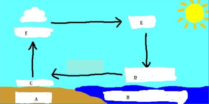
i) The type of breeze shown on the diagram above is________________________
ii) A stands for_______________________
B stands for_______________________
C stands for_______________________
D stands for_______________________
E stands for_______________________
- a)Explain the term map
__________________________________________________________________________________________________________________________________________________________________________________________________________________________________________
b) With examples explain the following types of maps:
i) Topographical maps
________________________________________________________________________________________________________________________________________________________________________________________________________________________
ii) Statistical maps
________________________________________________________________________________________________________________________________________________________________________________________________________________________________________________________________________________________________
c) Examine five (5) characteristics of a good map:
i) __________________________________________________________________________________________________________________________________
ii) __________________________________________________________________________________________________________________________________
iii) __________________________________________________________________________________________________________________________________
iv) __________________________________________________________________________________________________________________________________
v) __________________________________________________________________________________________________________________________________
SECTION C
Attempt two questions
- Discuss the significance of atmospheric pressure in life (5 points)
- How walking long distance to the water sources affect the girl child? Explain (5 points)
- Describe ways of improving subsistence small scale agriculture. (5 points)
- a) What is river basin development project?
b) Examine the importance of river basin development projects in Africa (4 points)
1
LEARNINGHUBTZ.CO.TZFORM TWO GEOGRAPHY MODAL SERIES 12

 For Call,Sms&WhatsApp: 255769929722 / 255754805256
For Call,Sms&WhatsApp: 255769929722 / 255754805256 


