THE UNITED REPUBLIC OF TANZANIA NATIONAL EXAMINATIONS COUNCIL OF TANZANIA
CERTIFICATE OF SECONDARY EDUCATION EXAMINATION
013 GEOGRAPHY
(For Both School and Private Candidates)
Time: 3 Hours Year: 2020
Instructions
l . This paper consists of sections A, B and C with a total of ten (10) questions.
2. Answer all questions in section A and B and two (2) questions from section C.
3.Section A carries fifteen (15) marks, section B fifty five (55) marks and section C carries thirty (30) marks.
4.Map extract of Sikonge (Sheet 137/2) is provided.
5.Programmable calculators, cellular phones and any unauthorised materials are not allowed in the examination room.
6.Write your Examination Number on every page of your answer booklet(s).
SECTION A (15 Marks)
Answer all questions in this section.
1. For each of the items (i) (x), choose the correct answer from among the given alternatives and write its letter in the answer booklet(s) provided. (10 marks)
(i)Why does the sun appear larger than other stars that are seen at night?
Starlight bends as it passes planets
The sun is closer to the earth than other stars
The earth's atmosphere filters out light from other stars
Daylight brightens the sun making it appear larger
The capacity of our eyes does not view far during the night
Choose Answer :
(ii)Which layer of the earth forms the ocean floor'?
Mantle
Sial
Sima
Core
Crust
Choose Answer :
(iii) In the field study, students were told that, soil has certain biological, chemical and physical characteristics. What is the general term for these characteristics?
soil profile
soil particles
soil properties
soil fertility
soil formation.
Choose Answer :
(iv)A girl was crossing a river and accidentally dropped her school bag in the river. The girl cried as she observed her bag being pulled by the river water toward the river mouth. What could the bag named in relation to the river action?
River erosion
River transportation
River load
River meander
River bed
Choose Answer :
(v)Which of the following factors is not the cause of desertification in Tanzania?
Deforestation
Urban growth
Shifting cultivation
Over fishing
Bush fire
Choose Answer :
(vi)Suppose you were interested in developing energy from the remains of living things. What will be the best raw material for your project?
Running water
Petroleum
Solar energy
Coal
Natural gas
Choose Answer :
(vii)The Amazon and Congo basins are regions characterised with the same geographical background to human activities, climate, vegetation and relief. What could be the general term for these regions?
Natural region
Natural resources
Natural vegetation
Natural landscape
Natural climate
Choose Answer :
(viii)Suppose you were given several types of minerals and you were asked to select three non-metallic minerals. What would be your selection from the following alternatives?
Coal, gold and copper
Natural gas, silver and diamond
Oil, diamond and coal
Copper, silver and oil
Gold, natural gas and diamond
Choose Answer :
(ix)The tourists enjoyed the temperature of Zanzibar which was at sea level. They also planned to travel from Zanzibar to Manyara which is 1500m above sea level. What will be the temperature experienced by the tourists in Manyara?
230C
90C
190C
0.60C
170C
Choose Answer :
(x)Which of the following occurs when the moon's shadow cast over the earth?
Solar eclipse
Lunar eclipse
Aphelion
Summer solstice
Equinoxes
Choose Answer :
2.Match the descriptions of the types of agriculture in List A with the correct type of agriculture in List B by writing the letter of the correct response beside the item number in the answer booklet(s) provided. (5 marks)
List A
List B
(i)Crop cultivation practiced in a small plot of land.
(ii)System of agriculture in which land is cultivated and left for some years to improve its fertility.
(iii)Traditional system of crop cultivation in which farmers move to new farm land when the yields are low.
(iv)Activity of growing crops and rearing livestock.
(v)System of agriculture in which farms are owned by Government, Co-operatives and Private Companies.
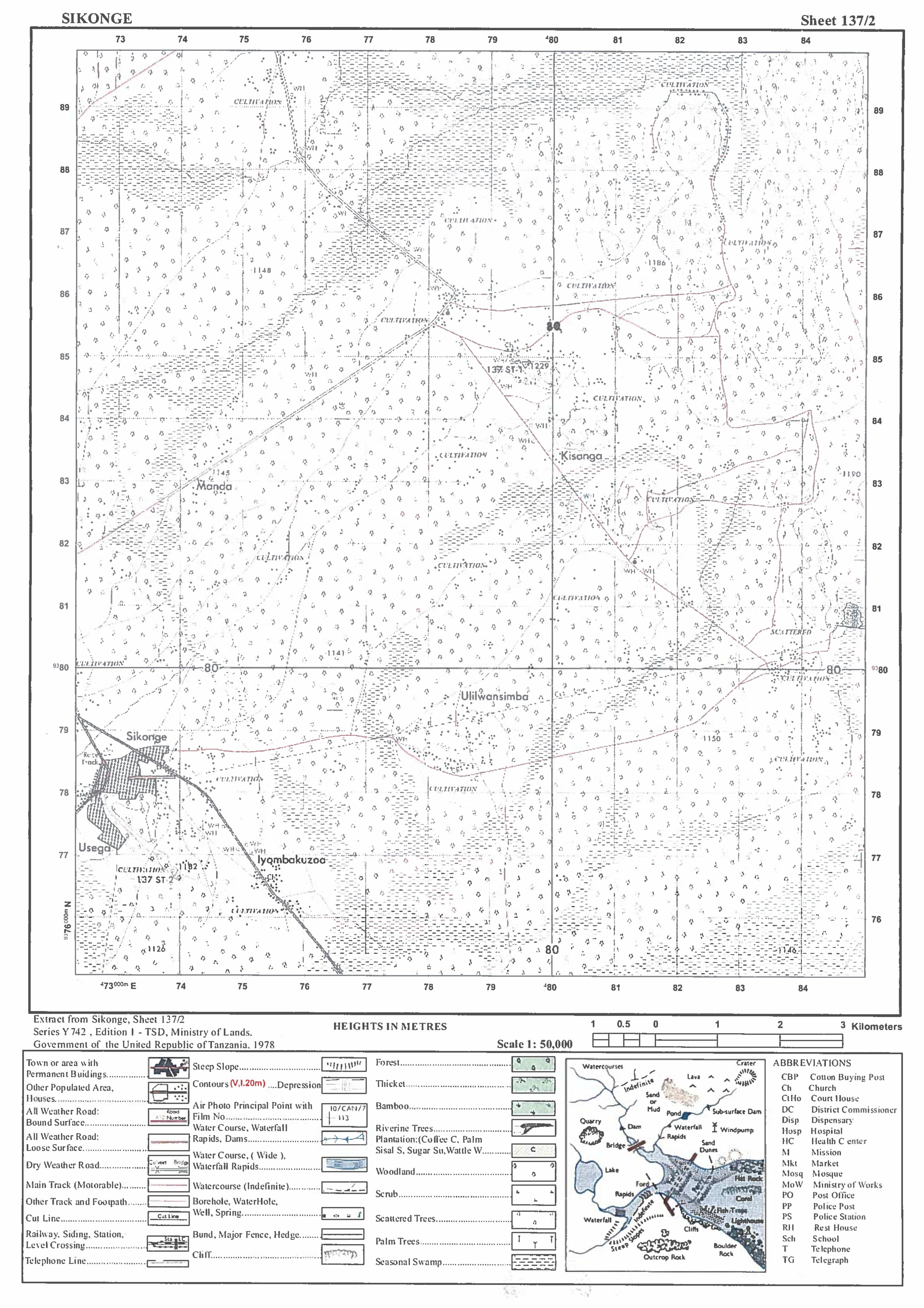
3.Carefully study the map extract of Sikonge (Sheet 137/2) provided, then answer the following questions:
(a) Calculate the total distance covered in Kilometers if the car was travelling from Sikonge town (732787) to Iyombakuzoa church (755765) and turned back to Sikonge town.
(b)With evidence from the map, describe the nature of relief in the mapped area.
(c)Calculate the gradient from grid reference 835846 to 782786.
(d)Find the highest point on the given map and give its grid references and direction.�
(e) State the general direction of slope of the land in the mapped area.
5.Suppose you want to conduct a research about maize production in your district from 2008 to 2018 and your interest is to know whether the production has increased or decrease. Your plan is to consult farmers who were directly involved in the maize production for the said period and visit the District Agriculture Officer for more information.
(a)What will be the best research approach for your study'?
10. The Form Three students were told by their Geography teacher to perform a survey activity around the school compound. Explain eight pre-survey activities they need to consider?

 For Call,Sms&WhatsApp: 255769929722 / 255754805256
 Matokeo Darasa VII 2025
Matokeo KIDATO CHA II 2024
Matokeo Darasa VII 2025
Matokeo KIDATO CHA II 2024


