THE UNITED REPUBLIC OF TANZANIA NATIONAL EXAMINATIONS COUNCIL
CERTIFICATE OF SECONDARY EDUCATION EXAMINATION
013 GEOGRAPHY
(For School Candidates Only)
Time: 3 Hours Tuesday, 5 th October 2010 a.m.
Instructions
1. This paper consists of sections A, B, C and D.
2. Answer all questions in sections A, B and C and one (1) question from each part of section D.
3. Map extract of LINDI is provided.
4. Credit will be given for the use of relevant sketch maps and diagrams.
5. Calculators and cellular phones are not allowed in the examination room.
6. Write your Examination Number on every page of your answer booklet(s)
SECTION A (25 Marks)
Answer all questions in this section.
PHYSICAL AND MATHEMATICAL GEOGRAPHY
1. For each of the items (i) � (x), choose the correct answer from among the given alternatives and write its letter beside the item number.
(i) Crater lakes are most likely to be formed in
areas of fold mountains intensively faulted areas downwarped areas regions where subsidence is taking place areas of active vulcanicity. Choose Answer :
- -
A
B
C
D
E
(ii) Which one of the following is not associated with earthquakes?
Body waves Geyser Richter scale Seismograph Focus. Choose Answer :
- -
A
B
C
D
E
(iii) If the time at town X 15�E is 12.00 noon, what could be the longitude of town Y if it is 8.00 a.m?
15�W 30�E 45�W 30�W 45�E Choose Answer :
- -
A
B
C
D
E
(iv) Which one of the following, by origin and composition is not a form of igneous rocks?
Sill Gypsum Lava plain Volcano Granite. Choose Answer :
- -
A
B
C
D
E
(v) One of the following features is a product of weathering:
Earth pillar Gully Lilly Hot springs Soil creep. Choose Answer :
- -
A
B
C
D
E
(v) One of the following features is a product of weathering:
Earth pillar Gully Lilly Hot springs Soil creep. Choose Answer :
- -
A
B
C
D
E
(vii) A scale of 4 cm representing 18 km on the ground will be represented by representative fraction (R.F) scale as
1 : 900000 1 : 1800000 1 : 450000 2 : 900000 1 ? 10,000 Choose Answer :
- -
A
B
C
D
E
(viii) Which one of the following owes its origin to deflation?
Qattara depression Lake turkana Tekekitarn Lake Chad Lake Victoria. Choose Answer :
- -
A
B
C
D
E
(ix) The presence of paired terraces on both sides of a river valley indicates that
river capture has taken place lateral erosion is dominant sea level has risen rejuvenation has taken place truncated spurs have retreated. Choose Answer :
- -
A
B
C
D
E
(x) A good example of intrusive igneous rocks is
gneiss basalt gabbro marble imestone. Choose Answer :
- -
A
B
C
D
E
2. Match the items in List A with the responses in List B by writing the letter of the correct response beside the item number.
LIST A LIST B (i) Saucer�shaped structure of permeable rock layer lying between two impermeable rocks (ii) A process by which wind transport loose materials
(iii) Part of the land that lies between high water and low water
(iv) A volcano made of viscous lava
(v) One of the components of soil
Deflation Shore Soil porosity Saltation Coastline Artesian basin Composite cone Inorganic matter Aquifer Cummulo dome
View Ans 3. (a) What is meant by marine erosion?
(b) Describe four (4) processes which are involved in marine erosion.
View Ans SECTION B (27 Marks)
Answer all questions this section.
APPLICATION OF STATISTICS, INTRODUCTION TO RESEARCH AND ELEMENTARY SURVEYING
4. Carefully study the data in the table below showing importation of motor vehicles from Europe in 2009, and answer the questions that follow:
Name of Motor Vehicle
Number of Motor Vehicle
JEEP
430
BENZ
192
BMW
108
RIMOUSSENE
70
(a) Draw a divided circle to represent the data.
(b) Show the disadvantages of the method you have used in (a) above.
View Ans 5. Hypothesis formulation can be used in both qualitative and quantitative research. Examine the problems faced in hypothesis formulation
View Ans 6. The chairman of Mivumoni village advised his village mates to use simple chain survey in order to get the right measurements of their farms. Show the merits and demerits of simple chain survey.
View Ans SECTION C (28 Marks)
Answer all questions in this section.
MAP READING AND PHOTOGRAPH INTERPRETATION
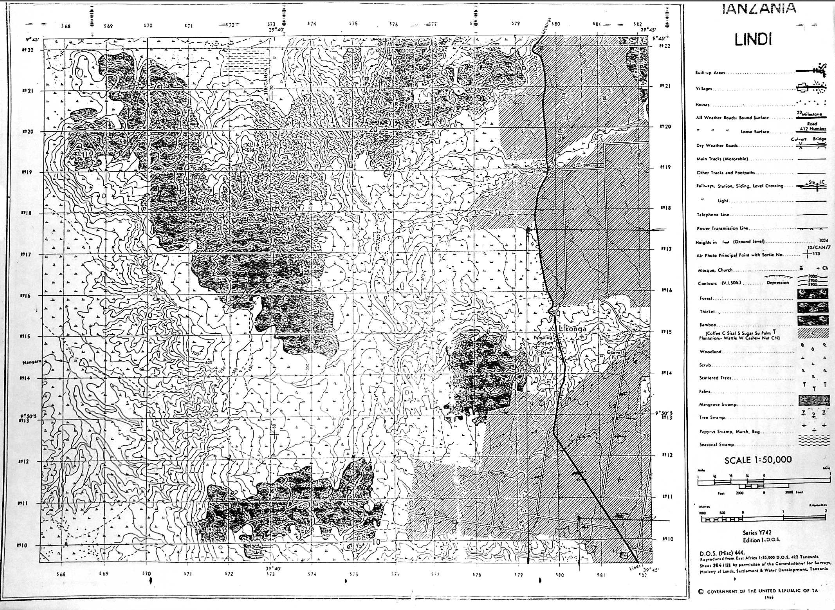
7. Carefully study the map Extract of LINDI provided, and then answer the following questions.
(a) Explain the possible reasons for the uneven population distribution in the area.
(b) How long in Kilometers is the Lindi�Nachingwea all�weather road (bound surface).
(c) Giving two evidence from the map, name the type of climate experienced in this area.
(d) How big in Km2 is the area covered by the forest south of grid line 160?
View Ans 8. Carefully study the photograph provided below and then answer the questions that follow.
(a) Name the crop shown in the photograph.
(b) Mention the natural conditions which favour the growth of the crop
(c) Tanzania is very famous in growing the crop mentioned in (a) above. Name the regions of Tanzania which grow the crop at commercial level.
(d) With concrete evidence, explain the scale of production as shown on the photograph.
View Ans SECTION D (20 Marks)
Answer one (1) question from each part.
PART 1: REGIONAL FOCAL STUDIES
9. In order to achieve economic development, transport and communication are inevitable. Describe the significance of transportation in developing countries.
View Ans 10. Discuss the reasons for the low level of industrial development in Sub�Saharan Africa.
View Ans PART II: ENVIRONMENTAL ISSUES, POPULATION AND SETTLEMENT
11. Examine the best ways which can ensure a sustainable use of forestry resources.
View Ans 12. How does rapid population explosion affect small scale agriculture?
View Ans 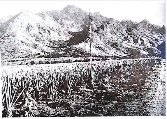

 For Call,Sms&WhatsApp: 255769929722 / 255754805256
 Matokeo Darasa VII 2025
Matokeo KIDATO CHA II 2024
Matokeo Darasa VII 2025
Matokeo KIDATO CHA II 2024


