THE UNITED REPUBLIC OF TANZANIA NATIONAL EXAMINATIONS COUNCIL OF TANZANIA CERTIFICATE OF SECONDARY EDUCATION EXAMINATION
GEOGRAPHY
(For Both School and Private Candidates)
Time: 3 Hours Year: 2004
SECTION A
PHYSICAL AND MATHEMATICAL GEOGRAPHY
1. For each of the items (i) — (x) choose the correct answer from among t he given alternatives and write its letter beside the item number.
(i) River erosion operates in three ways, namely:
- surface, vertical and lateral
- headward, vertical and surface
- lateral, frontal and surface
- frontal lateral and headward
- lateral, subsurface and surface.
Choose Answer :
(ii) The magnitude of an earthquake refers to:
- effects produced by the earthquake
- large amplitude waves known as L-waves
- point at which earthquake originates
- total amount of energy released
- point on the earth surface above the focus
Choose Answer :
(iii)If Ronaldo scores a goal for his team playing in Colombo (800E) at 4:00pm local time. What will be the time at Mtwara in Tanzania (400E)?
- 6:40 a.m.
- 1:20 a.m.
- 6.40 p.m.
- 1:20 p.m.
- 2:40 p.m.
Choose Answer :
(iv)Plants with long roots, thorny stems, needle shaped leaves, wax or hair are found in:
- the Mediterranean region
- hot deserts
- tropical grasslands
- the equatorial region
- the monsoon region
Choose Answer :
(v)The part of the earth that forms continental blocks is called:
- Sima
- Core
- Mantle
- Sial
- hydrosphere
Choose Answer :
(vi)The temperature of Dar es Salaam at sea level is 31 0C. Whatwill be the temperature of Arusha 2500 metres above sea level?
- 160C
- 290 C
- 150C
- 460 C
- 32.5 0C
Choose Answer :
(vii) Reverse fault is mainly caused by:
- earth movement
- tension force
- an earthquake
- weathering
- compressional force
Choose Answer :
(viii)Which one among the following features occurs in a glaciated lowland region?
- Esker
- Cirque
- Pyramidal peak
- Hanging valley
- Arete
Choose Answer :
(ix)The slow movement of soil particles which can be recogniæed by bending of trees and fences is referred to as:
- land slide
- mud flow
- soil creep
- rock fall
- soil erosion
Choose Answer :
(x)A drainage system of a river where the river flows in accordance with the rock structure is called:
- discordant drainage system
- antecedent drainage system
- superimposed drainage system
- back tilted drainage system
- Accordant drainage system
Choose Answer :
2. Match the responses in List B with the phrases in List A by writing the letter of the correct response beside the item number.
| LIST A | LIST B |
| (i) Used to plot routes for ships crossing large stretches of oceans and aircrafts flying great distances (ii) It builds up when a glacier is stationary (iii) A broad tidal channel of a river where it enters the sea (iv) The hardest part of the earth's crust (v) A large closed depression formed in the Karst region | - Uvala
- Lithosphere
- Great circles
- Mesa
- Terminal moraines
- Hydrosphere
- Grid reference
- Soil creep
- Estuary
- Delta
|
View Ans
SECTION B
STATISTICS, RESEARCH TECHNIQUES AND SIMPLE SURVEYING AND LEVELLING
3.With the aid of a diagram(s) describe the formation of an ox-bow lake.
View Ans
4. Study carefully the weather statistical data for station X given below then answer the questions that follow:-
| Month | J | F | M | A | M | J |
| Temps (C) | 28 | 27 | 27 | 27 | 28 | 28 |
| Rainfall (mm) | 2400 | 2100 | 2050 | 1750 | 1700 | 1750 |
| Month | J | A | S | O | N | D |
| Temps (C) | 26 | 25 | 24 | 26 | 27 | 28 |
| Rainfall (mm) | 1600 | 1500 | 1700 | 1805 | 2100 | 2300 |
(a)Calculate the annual mean temperature.
(b)Calculate the annual rainfall.
(c) Determine the temperature mode and median.
(d) Name three cash crops that can be grown in the area surrounding station X.
(e) With reasons suggest the type of climate of station X.
View Ans
5.Explain briefly the following concepts as applied in research:
(a)Descriptive research.
(b)Applied research
(c) Quantitative research
(d) Research tools
(e) Sampling techniques
View Ans
6.(a) Define the term levelling.
(b) Give the significance of levelling.
View Ans
SECTION C
MAP READING AND PHOTOGRAPH INTERPRETATION
7.Study carefully the map extract of MAFINGA sheet 232/4 provided then answer the following questions:-
(a) Find the distance of TAZAMA pipeline from grid reference 480786 to grid reference 547830 in kilometers.
(b) Describe the settlement pattern of the area shown in the map.
(c) Determine the direction at which river Little Ruaha flows.
(d) With evidence state three economic activities taking place in the area.
(e) How has the amount of rainfall influenced the type of vegetation shown in the map?
View Ans
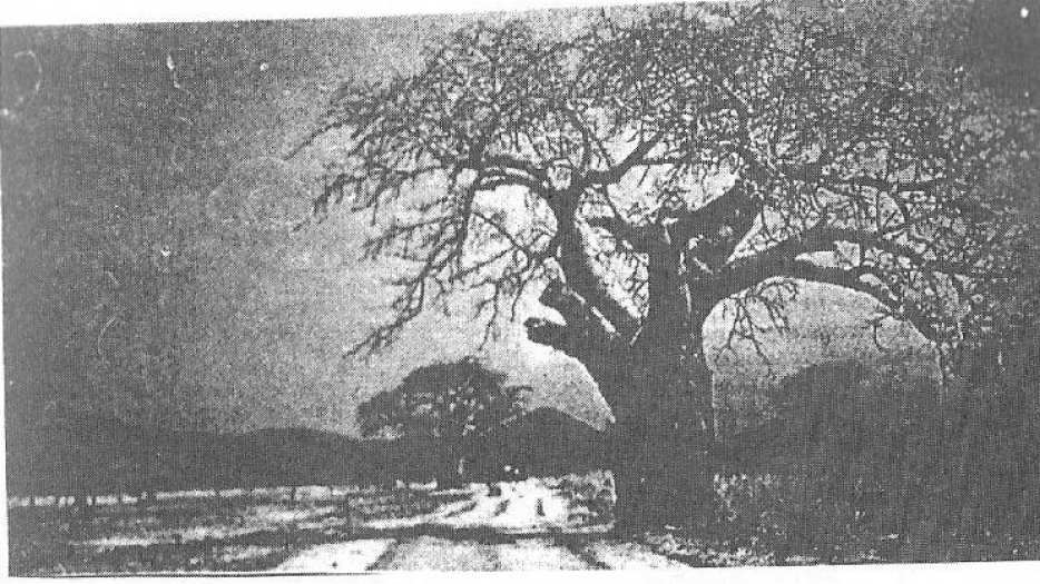
8.Study carefully the photograph below then answer the questions that follow:-
(a)Name the of photograph.
(b)Describe the possible climate of the area.
(c)Suggest the economic activities that might be taking place in the area.
(d)From which part of Tanzania was this photograph taken?
View Ans
SECTION D
PART I REGIONAL FOCAL STUDIES
9. (a) Giving example from Tanzania, explain large scale farming.
(b) What are the disadvantages of large scale farming in Tanzania?
View Ans
10.(a) Discuss the factors for the development of ship manufacturing in Japan.
(b) Why is ship manufacturing important to Japan?
View Ans
PART II: ENVIRONMENTAL ISSUES, POPULATION AND DEVELOPMENT
11.State and explain the determinants of age structure in a population.
View Ans
12.Explain the forms of environmental problems facing Tanzania. What measures are taken to solve those problems?
View Ans

 For Call,Sms&WhatsApp: 255769929722 / 255754805256
 Matokeo Darasa VII 2025
Matokeo KIDATO CHA II 2024
Matokeo Darasa VII 2025
Matokeo KIDATO CHA II 2024


