(i) The time recorded along the same meridian is called:
A. Local mean time
B. Greenwich Mean Time
C. Great Mean Time
D. Standard time
Choose Answer :
(ii) The following planet has 8 satellites:
A. Mars
B. Jupiter
C. Neptune
D. Saturn
Choose Answer :
(iii) Fold mountains are mainly produced by:
A. Tension force
B. Earthquakes
C. Compression force
D. Faulting
Choose Answer :
(iv) Part of the earth which forms continental blocks is:
A. Sima
B. Core
C. Sial
D. Hydrosphere
Choose Answer :
(v) What is the local mean time of Dar es Salaam at 45 0E when it noon at
Greenwich?
A. 10.00 a.m.
B. 7:00 p.m.
C. 3.00 p.m.
D. 8:00 p.m.
Choose Answer :
(vi) The only type of climate that is different from the others is:
A. Mediterranean
B. Savanna
C. Hot desert
D. Equatorial
Choose Answer :
(vii)Wind blows from:
A. Low altitude to high altitude
B. Low pressure to high pressure zone
C. High pressure to low pressure zone
D. Sea to land during nights
Choose Answer :
(viii)Which is the largest among the following scales?
- 1:25,000
- 1:500,000
- 1:50,000
- 1:10,000
Choose Answer :
(ix) Identify the incorrect association in the following pairs:
A. Isobar and sunshine
B. Isobar and pressure
C. Isotherm and temperature
D. Isohyets and rainfall
Choose Answer :
(x) WSW compass direction is equivalent to the following compass bearing:
A. 2250
B. 135 0
C. 245.50
D. 247.50
Choose Answer :
THE UNITED REPUBLIC OF TANZANIA MINISTRY OF EDUCATION AND VOCATIONAL TRAINING
FORM TWO SECONDARY EDUCATION EXAMINATION, 2005
0013 GEOGRAPHY
TIME: 2½ HOURS
INSTRUCTIONS
1. This paper consists of sections A and B.
2. Answer ALL questions in section A and ONLY two questions from Section B.
3. Write your examination number on every page.
4. ALL answers in both sections must be written in this paper.
5. Cellphones and electronic calculators are not allowed in the examination room.
6. ALL writing must be in black or blue pen.
SECTION A
Read the following statements carefully and then write the letter of the most correct answer.
(i)The time recorded along the same meridian is called:
- Local mean time
- Greenwich Mean Time
- Great Mean Time
- Standard time
Choose Answer :
(ii)The following planet has 8 satellites:
- Mars
- Jupiter
- Neptune
- Saturn
Choose Answer :
(iii)Fold mountains are mainly produced by:
- Tension force
- Earthquakes
- Compression force
- Faulting
Choose Answer :
(iv) Part of the earth which forms continental blocks is:
- Sima
- Core
- Sial
- Hydrosphere
Choose Answer :
(v)What is the local mean time of Dar es Salaam at 45 0E when it noon at Greenwich?
- 10.00 a.m.
- 7:00 p.m.
- 3.00 p.m.
- 8:00 p.m.
Choose Answer :
(vi)The only type of climate that is different from the others is:
- Mediterranean
- Savanna
- Hot desert
- Equatorial
Choose Answer :
(vii)Wind blows from:
- Low altitude to high altitude
- Low pressure to high pressure zone
- High pressure to low pressure zone
- Sea to land during nights
Choose Answer :
(viii)Which is the largest among the following scales?
- 1:25,000
- 1:500,000
- 1:50,000
- 1:10,000
Choose Answer :
(ix) Identify the incorrect association in the following pairs:
- Isobar and sunshine
- Isobar and pressure
- Isotherm and temperature
- Isohyets and rainfall
Choose Answer :
(x) WSW compass direction is equivalent to the following compass bearing:
- 2250
- 1350
- 245.50
- 247.50
Choose Answer :
2. Match the items in COLUMN A with the corresponding items in COLUMN B
| COLUMN A | COLUMN B |
| (i)Branches of Geography (ii)The furthest planet (iii)World solstice (iv)Experience longer days or nights at some periods of the year (v) Core (vi)Layers of the atmosphere (vii)Continental shelf, continental slope and trench. (viii) Weather (ix)Convection rainfall (x)An instrument used to measure curved distance on maps | - Pair of piders
- Troposphere, stratosphere, mesosphere and thermosphere
- Causes seasons
- Pluto
- Ocean floor features
- Physical, Human and Practical Geography
- Precipitation caused by intensive solar radiation
- When the sun appears to be overhead at latitudes 23L ON and 23LO S
- Temperature
- The condition of an atmosphere which occurs at a specific time
- An area of high pressure belt
- It is made up of iron and manganese silicate
|
View Ans
3. Write TRUE or FALSE against the statement given:
(i) When contour lines are close to one another this means that there is a gentle slope over the landform. .........
(ii)Lines of latitude are sometimes called parallels. .........
(iii)Asteroids are solid heavenly bodies revolving around the sun mostly between the orbit of Mars and Jupiter. .........
(iv)See breeze occurs when wind blows from the land to the sea. .........
(v)Lakes Victoria, Kioga and Chad are among the Rift Valley lakes. .........
(vi) If one crosses the International Date Line westwards one gains a day.
(vii) In order to read grid references start with Northings and finish with Eastings. .........
(viii) Penumbra is a small dark shadow. ..
(ix) Watershed is the collecting ground for a single river system .........
(x) Europe is the continent which is crossed by both Tropics of Cancer and Capricorn. .........
View Ans
4. (a) Study the map provided then answer the questions that follow:
| 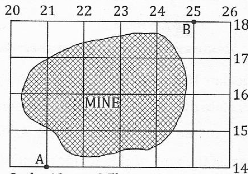
Scale: 10m to 0.5km |
(i) Calculate the area of the mine.
(ii) Find the bearing of point B from A.
(iii) Give the direction of A from B.
(iv) State the grid reference of A and B.
View Ans
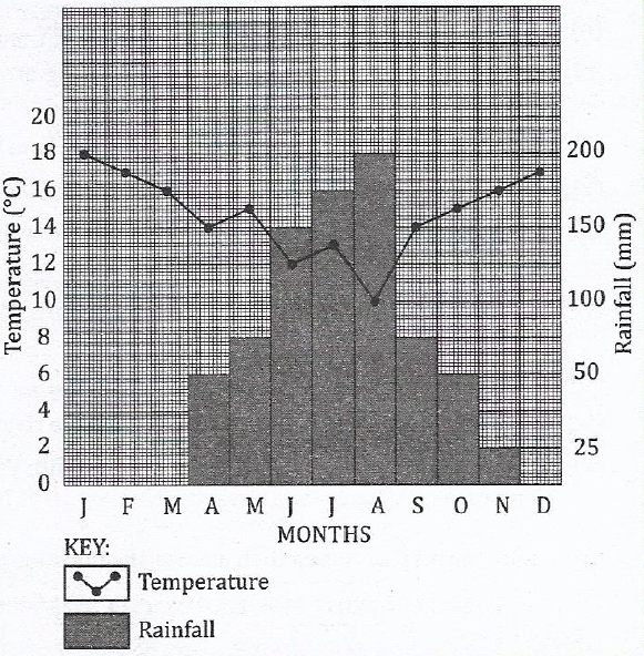
(b) Carefully study the climatic graph given and then answer the questions that follow.
(i) Calculate the annual range of temperature.
(ii) Calculate the annual rainfall for the station.
(iii)Calculate the mean annual rainfall for the station.
(iv)Suggest the type of climate for the station.
(v) Give reasons for the suggestion you have given in (iv) above.
View Ans
5. (a)(i) Define deforestation.
(ii) List down three causes of deforestation.
View Ans
(b) Mention four forms of transport.
View Ans
(c) Outline four difficulties which face the improvement of agriculture sector in Tanzania.
View Ans
(d) Mention problems that hinder development of the tourism sector in Tanzania.
View Ans
(e) Outline four measures which should be taken to improve trade in developing countries.
View Ans
(f) Name any four types of irrigation systems.
View Ans
(g) Write down the necessary conditions for the location of an industry.
View Ans
(h) Mention the benefits of establishing the Tennessee Valley Authority in USA.
View Ans
(i) What is the importance of developing river basin schemes in Africa?
View Ans
(j) State four ways of empowering women in small scale agriculture.
SECTION B
View Ans
6. Explain the factors which prevent development of the fishing industry in East Africa.
View Ans
7. What are the ways of minimizing pollution caused by mining to the environment?
View Ans
8. Outline the aspects that have contributed to the development of dairy farming in the Netherlands.
View Ans
9. Describe the consequences of water shortage to communities.
View Ans
10. Give an illustration of the advantages of sedentary farming.
View Ans

 For Call,Sms&WhatsApp: 255769929722 / 255754805256
 Matokeo Darasa VII 2025
Matokeo KIDATO CHA II 2024
Matokeo Darasa VII 2025
Matokeo KIDATO CHA II 2024


