
FORM TWO GEOGRAPHY EXAM SERIES 221
FORM TWO GEOGRAPHY EXAM SERIES 221
THE PRESIDENT’S OFFICE
REGIONAL ADMINISTRATION AND LOCAL GOVERNMENT
SECONDARY SCHOOL EXAMINATION SERIES
GEOGRAPHY FORM TWO
PRE-NECTA-2025
CODE 012
TIME: 2:30 HOURS
INSTRUCTIONS.
- This paper consists of section A, B and C with the total number of ten(10) questions
- Answer all questions in each section
- Section A carries (15) marks, section B (70) marks and section C carries (15) marks
- All writing must be in blue/black ink except drawing which must be in pencil
- Cellular phones and any unauthorized materials are not allowed in the assessment room.
SECTION A (15 Marks)
Answer all questions in this section
i. The instrument at the weather station which is painted white and is used for storing other weather instruments is known as a
- Barometer
- Wind vane
- Stevenson screen
- Rain gauge.
ii. Lines of longitude measure distances:
(A) North and South from the Equator
(B) East and West from the Prime Meridian
(C) Around the Earth's circumference
(D) From the Earth's surface to its center
iii. A map showing important natural and human made feature is known as
- A topographical map
- A statistical map
- A distribution map
- An atlas map.
iv. Which type of mountains are formed when a movement in the earth’s crust forces the rocks to break and form faults?
- Block Mountains
- Fold Mountains
- Residual Mountains
- Volcanic Mountains.
v. Geography connects to other subjects, like science and history, because:
(A) Many things happen on Earth, which is related to lots of subjects
(B) It's the most important subject
(C) You need maps to study anything
(D) You don't need other subjects
vi. Which one of the following climatic elements is not influenced by temperature?
- Humidity
- Rainfall
- Pressure
- Condensation
vii. An agricultural activity which involves crop production in a small piece of land is called?
- Shift cultivation
- Arable farming
- Subsistence farming
- Sedentary farming
viii. What if timber as used in Geography?
- Is the wood materials derived from the forests.
- Collection of timber products
- Production of forest resources.
- Good management of forest resources.
ix. The production of bulk products like iron, steel, car assembly and ship building is referred to as:-
- Heavy industry
- Simple or light industry
- Secondary industry
- Primary industry
x. Major categories of minerals are:-
- Metals and non – metals
- Reactants and non – reactants.
- Chemicals and non – chemicals
- Organic and inorganic minerals
2. Match the following heavenly bodies in LIST A with their description in LIST B
| LIST A | LIST B |
| A. Large, round celestial body that orbits a star B. A bright streak of light caused by a space rock burning up in the atmosphere C. A celestial body with sufficient mass for self-gravity to hold a spherical shape D. Relatively small object orbiting the Sun, mainly found in the Asteroid Belt E. Icy object with a tail of gas and dust when near the Sun |
3. (a) What is the difference between climate and weather?
(b) What is the importance of climate to human activities.
4. (a) Define the term transport
(b) Name the three major forms of transport
5. (a) List the advantage and disadvantages of sea transport
(b) Name two lakes used for transport purposes in East Africa
6. (a) Name four relief features of the ocean flow
- ………………………………………………………….
- ………………………………………………………….
- ………………………………………………………….
- ………………………………………………………….
(b). Identify two types of ocean Currents
- …………………………………………………………
- …………………………………………………………
7. Discuss problems facing large scale agriculture in Tanzania.
8. Which are the factors influencing mineral exploitation?
9. Point out disadvantages faced by women or girls who walk for a long distance looking for firewood.
SECTION C
10. Mr. Sagutinho is an investor from Brazil who wants to start a manufacturing industry in Tanzania. Which are the factors to consider where to locate his manufacturing industry?
FORM TWO GEOGRAPHY EXAM SERIES 213
FORM TWO GEOGRAPHY EXAM SERIES 213
Student index number.......................................................
PRESIDENTS OFFICE
REGIONAL ADMINSTRATION AND LOCAL GOVERNMENT
SECONDARY EXAM SERIES
FORM TWO PRE MOCK EXAMINATION
GEOGRAPHY
CODE 013
TIME: 2:30 HRS. APRIL 2025
Instructions
1. This paper consists of sections A, B and C with a total of ten (10) questions.
2. Answer ALL questions.
3. Section A and C carry fifteen (15) marks each and section B carries seventy
(70) marks.
4. All writings must be in blue or black ink and should be written in the space
provided.
5. Cellular phones, calculators and any unauthorized materials are not allowed in the examination room,
6. Write your examination number at the top right corner of every page.
SECTION A: (15 Marks)
Answer All questions in this section
1. For each of the items (i) – (x), choose the correct answer from among the given alternatives and write its letter in the box provided below.
(i) Miss Asha is a small animal keeper at the village, she has two cows and she normally uses a rope to tie them to the post at one end of the rope and the other side being tied to the cow’s leg. Which process is this?
A. Zero grazing
B. Transhumance
C. Tethering
D. Nomadism
E. Sedentary
(ii) Jesca was swimming at deep sea on the way she met a long, narrow, steep sided elongation plunging from the deep-sea plain. What is the common name of the feature?
A. oceanic ridge
B. Continental shelf
C. Ocean
D. Deep Sea plain
E. Ocean floods
(iii) Suppose you want to carry out a field study on the atmospheric conditions suitable for growth of banana on village farm. What are the best weather components to be considered?
A. Rainfall and wind
B. Rainfall and cloud cover
C. Moisture and sunshine
D. Rainfall and temperature
E. Pressure and humidity
(iv) The Tourists enjoyed the temperature of Kilwa which was 32°C at sea level. They also planned to travel from Kilwa to Mwanza which is 1500M above sea level. What will be the temperature experienced by tourists in Mwanza?
A. 9°C
B. 19°C
C. 23°C
D. 0.6°C
E. 29°C
(v) A form of human activities which involves extraction of resources from the natural environment is
A. Primary activities
B. Secondary activities
C. Quaternary activities
D. Quinary activities
E. Tertiary activities
(vi) Which type of mountain is formed by prolonged denudation?
A. Block mountains
B. Residual mountains
C. Volcanic mountains
D. Fold mountains
E. Extinct volcanic mountain
(vii) Which of the following cannot be used effectively to locate a place on a map?
A. Place names
B. Altitude
C. Grid reference
D. Bearing and direction
E. Longitude and Latitude
viii) A farmer planted maize, cassava, watermelon and beans on the same farm. This process is called.
A. Bush fallowing
B. Shifting cultivation
C. Mixed farming
D. Manufacture
E. Intercropping
(ix) The environmentalist emphasizes the people on the use of solar energy as the source of energy in their daily activities due to the fact that solar energy is:
A. Non-renewable energy
B. Non energy
C. Renewable energy
D. Available energy
E. Environmentally friendly energy
(x) Form Two students from Njombe Girls Secondary School visited different historical sites found in Bagamoyo. Identify the type of tourism they were involved in:
A. Cultural tourism
B. International tourism
C. Eco-tourism
D. Domestic tourism
E. Artificial tourism
2. Match the description of Geographical term in LIST A with the corresponding correct item in LIST B by writing a correct response below in term of number provided
| LIST A | LIST B |
|
|
SECTION B (70 Marks)
Answer all questions in this section
`
3. Form one students from Kiwanjani Boys Secondary School visited the weather station at Kilimanjaro region; they saw various instruments and devices. One device was white wooden box, a box had louvers all the sides and double boarded roof. If mounted on a stand 121 cm above the ground, it was the first time for form one students to see that device.
a) As a form two student, identify the name of that device
________________________________________________________
b) Why do you think the device was having the following characteristics
i. Paint white
__________________________________________________
ii. Had louvers to all sides
__________________________________________________
c) Name the two (2) major instruments kept in it
(i) ___________________________________________________
(ii) ___________________________________________________
d) Mention the uses of instruments mentioned above.
(i) ___________________________________________________
(ii) ___________________________________________________
e) List one (1) importance of that station in our daily life
(i) ___________________________________________________
4. A resource is anything that can be utilized if necessary. Ambwene is a fisherman who uses to catch fishes from Lake Victoria for food and Commercial purposes.
(a) Identify the type of activity mentioned above
__________________________________________________________________
(b) Explain any four characteristics of small-scale crop cultivation
(i)…………………………………………………………………………………….
(ii)……………………………………………………………………………………
(iii)…………………………………………………………………………………..
(iv)…………………………………………………………………………………..
5. (a) Outline five importance of human economic activities
(i) …………………………………………………………………………………
(ii)…………………………………………………………………………………
(iii)………………………………………………………………………………….
(iv)………………………………………………………………………………….
(v)………………………………………………………………………………….
(b) Mention the three environmental problems associated with human activities
i) ____________________________________________________________
ii) ____________________________________________________________
iii) ____________________________________________________________
(c) Water is useful in the growth of any country’s economy. Mention two
product obtained from water.
(i)…………………………………………………………………………………
(ii)………………………………………………………………………………..
6. Maasai in Tanzania are famous in livestock keeping. They normally keep their animals by moving from one place to another with their herds in searching of water and pastures.
a) What is the system of livestock keeping they practice?
_________________________________________________________
b) Outline the three environmental advantages transhumance
(i)…………………………………………………………………………
……………………………………………………………………………
(ii)………………………………………………………………………
……………………………………………………………………………
(iii)………………………………………………………………………..
……………………………………………………………………………
c) Apart from Maasai suggest other two (2) societies in East Africa practicing
such system.
i. ______________________________________________________
ii. ______________________________________________________
d) List the three benefits of the livestock keeping identified in (a) above
i. ______________________________________________________
ii. ______________________________________________________
iii. ______________________________________________________
7. (a) Despite the highnumberof touristsin Tanzanians, we are still facing with problems
mention five (5) problems of tourism
(i)……………………………………………………………………….
(ii)………………………………………………………………………
(iii)………………………………………………………………………
(iv)………………………………………………………………………
(v)………………………………………………………………………..
8. The meteorological data obtained in sea meteorological center was as follows
| MONTH | J | F | M | A | M | J | J | A | S | O | N | D |
| TEMPERATURE (°C) | 13 | 16 | 20 | 25 | 28 | 35 | 36 | 35 | 32 | 26 | 19 | 14 |
| RAINFALL (mm) | 2.5 | 2.5 | 0 | 0 | 0 | 0 | 0 | 2.5 | 0 | 0 | 2.5 | 15 |
(i) Calculate the mean annual temperature for the station
(ii) Calculate the total annual rainfall for the station
(iii) give the annual range of temperature for the station
(iv) suggest the type of the climate.
(v) Outline the two crops which can be grown on the place
(a) ……………………………………………..
(b) ………………………………………………
9. Study careful the Map of MALAGARASI and then answer the following questions:
MALAGARASI SCALE 1:50,000
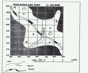
(i) Write grid references of the following points.
A…………………………………………………….
B……………………………………………………
C. ……………………………………………………
E……………………………………………………..
G…………………………………………………..
(ii) (a) Find the area of Kivu swamp in square kilometers
(iii) Express the given scale into Statement
(iv) Mention three (3) human activities found on the map.
(a) ……………………………………………………
(b)…………………………………………………….
(c) …………………………………………………..
SECTION C (15 Marks)
10. Analyze six problems facing small scale Agriculture in Tanzania
……………………………………………………………………………………………………………………………………………………………………………………………………………………………………………………………………………………………………………………………………
……………………………………………………………………………………………………………………………………………………………………………………………………………………………………………………………………………………………………………………………………
……………………………………………………………………………………………………………………………………………………………………………………………………………………………………………………………………………………………………………………………………
……………………………………………………………………………………………………………………………………………………………………………………………………………………………………………………………………………………………………………………………………
……………………………………………………………………………………………………………………………………………………………………………………………………………………………………………………………………………………………………………………………………
……………………………………………………………………………………………………………………………………………………………………………………………………………………………………………………………………………………………………………………………………
……………………………………………………………………………………………………………………………………………………………………………………………………………………………………………………………………………………………………………………………………
……………………………………………………………………………………………………………………………………………………………………………………………………………………………………………………………………………………………………………………………………
……………………………………………………………………………………………………………………………………………………………………………………………………………………………………………………………………………………………………………………………………
……………………………………………………………………………………………………………………………………………………………………………………………………………………………………………………………………………………………………………………………………
……………………………………………………………………………………………………………………………………………………………………………………………………………………………………………………………………………………………………………………………………
……………………………………………………………………………………………………………………………………………………………………………………………………………………………………………………………………………………………………………………………………
……………………………………………………………………………………………………………………………………………………………………………………………………………………………………………………………………………………………………………………………………
……………………………………………………………………………………………………………………………………………………………………………………………………………………………………………………………………………………………………………………………………
……………………………………………………………………………………………………………………………………………………………………………………………………………………………………………………………………………………………………………………………………
Page 1 of 10
FORM TWO GEOGRAPHY EXAM SERIES 204
FORM TWO GEOGRAPHY EXAM SERIES 204
OFFICE OF THE PRESIDENT, REGIONAL ADMINISTRATION AND LOCAL GOVERNMENT SECONDARY EXAMINATION SERIES
GEOGRAPHY FORM TWO-MID TERM-EXAMINATION
COMPETENCE BASED SECONDARY EXAMINATION SERIES
MARCH-APRIL-2025
INSTRUCTIONS
- This paper consists of three(3) sections A, B and C with a total of ten (10) questions
- Section A carries fifteen (15) marks, section B seventy (70) marks and section C fifteen (15) marks.
- Answer ALL questions in all sections
- Write your names and stream on the top center in every page of your examination
- ALL answers should appear in this question paper in the space provided.
SECTION A
1. For each of the items (i)-(x) choose the correct answer from among the given alternative and write its letter besides the item number in the answer booklet provided. (@1mark=10 marks)
i. Most of African societies are famous in moving with their livestock in search for water and pasture. Which among of the following are the examples of pastoralists’ societies in East Africa?
- Ngoni, Sukuma and Maasai
- Sangu, Kwavi and Hehe
- Sukuma, Gogo and Nyamwezi
- Maasai, Barbaig amajong
ii. The following below is the general term which refers to all things that attract tourists such as national parks, museums, good infrastructure and historical site?
- Tourism areas
- Tourism
- Tourists
- Tourism honey pot
iii. The keeping of livestock in Australia is mostly done in ranches where small pieces of land are prepared so as the livestock can be fed systematically to avoid overgrazing. These pieces of land prepared are commonly known as ..
- Paddocks
- Paddies
- Ranch
- Sheds
iv. Teaching is one of the examples of human activities that are performed in Tanzania by teachers. What kind of human activity performed by these people?
- Primary activity
- Tertiary activity
- Secondary activity
- Quaternary activity
v. The announcements about the trend of Covid 19 were announced in USA 56oW at 02:00p.m. At what longitude did Tanzanians supposed to listen the announcements if it was 08:24 p.m?
- 96oW
- 152oE
- 40oE
- 152oW
vi. Places in the East of Greenwich experience sun rise before places in the West because earth .
- Rotates from east to west
- Rotates from west to east
- Is very far from the sun
- Is very close to the sun
vii) The following are the measures to improve small scale agriculture in Tanzania except
- Establishing of cooperatives that can assist farmers
- Provision of soft loans for improved investment in agriculture
- Encouraging farmers to adopt plantation agriculture in rural areas
- Educating farmers on good farming techniques
viii. One of the form four students was wondering what causes the seasons of the year, you as a form one class who has been taught the causes of the seasons. What are the two causes would you explain to this student?
- Rotation and revolution
- Revolution and earth’s orbit of the earth’s axis
- Rotation and inclination of the earth’s axis
- Revolution and inclination
ix. Kigogo had a map which had lines on it joining various places with the same amount of clouds. The name of lines on Kigogo’s map are geographically called:
- Isonephs
- Isotherms
- Isokinetics
- Isobars.
x. The sun appears overhead at the equator twice a year 21st march and 21st June. These periods are commonly known as
- Summer and winter equinoxes
- Spring and summer equinoxes
- Spring and autumn equinoxes
- Winter and spring equinoxes
2. Match the following geographical events in LIST A with their corresponding dates in LIST B by writing the Letter of correspondence item in the box provided below (@1mark=5marks)
| LIST A | LIST B |
|
|
SECTION B 70 MARKS
Answer ALL questions in this section
3. Mr. Mabala had a farm, but he always used to cultivate maize. As time went on he wondered why the harvests were decreasing without knowing that monoculture was the problem. You as a form two student who knows different proper methods of farming, Piefly explain to him with five (5) of them so that he can continue having high production. (@2marks=10marks)
4. Carefully study the map extract of KILACHA HILL and answer the questions that follow
|
|
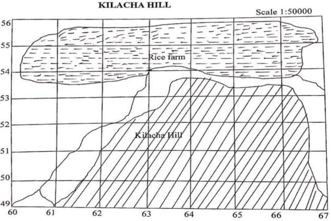
- Calculate the area covered by rice farm in KM2 given that the side of one is 2 centimeters ( 4marks)
- Mention two essentials that have been applied to draw that sketch map above (each 1 mark=2marks)
- Find the bearing and direction of grid reference 620500 from 650550 (2marks)
- Mention two (2) methods that can be used to locate position on the given sketch map. (2marks)
5. The process whereby water is transferred from the land to the air through plant roots and leaves vary from one place to another depends on the number of factors. You as an expert of this circumstance, briefly explain five (5) of them.
6. Always the oceanic floor is not uniform, it tends to vary from one place to another as it has different features. With this regard, draw a well labeled structure of the oceanic floor and indicate all eight (8) parts. (A good structure will weigh 2marks and well labeling, each 1mark=8marks)=10marks
7. (a) The establishment of an industry in a certain area depends on different issues. What makes different industries in Tanzania to be located where they are? Mention five (5) points.
(b) Minerals are useful in the growth of any country’s economy. List five (5) points to show how mining industries contribute to the economy of Tanzania.
8. (a) Convert the following scales according to the instructions given
- “One centimeter on the map represents two and half a kilometer on the ground”. Convert this scale into Representative fraction (R.F.) scale.
- 1:100000. Convert into statement scale.
- 1:50000. Convert into statement scale.
(b) State the compass direction for each of the following compass bearings.
- 280º ..
- 135º ..
- 45º ....
(c) How can the positions of objects be shown in any topographical map? Mention four(4) points.
9. Carefully study the data below and answer the questions that follow J
| Month | J | F | M | A | M | J | J | A | S | O | N | D |
| Temperature(oC) | 28 | 27 | 28 | 24 | 27 | 28 | 29 | 28 | 28 | 29 | 30 | 30 |
| Rainfall (mm) | 200 | 150 | 190 | 140 | 160 | 200 | 202 | 112 | 226 | 130 | 300 | 250 |
i. Calculate the total rainfall of the last six months of the given data (1 mark)
ii. Change the temperature range of the given data into degrees Fahrenheit (3 marks)
iii. Calculate the mean temperature of the given data (2 marks)
iv. With two reasons, identify the type of climate of the given data. (3marks)
Reasons
v. Mention two crops that may grow in the mentioned type of climate in 9(iv) above (each
SECTION C 15 MARKS
Answer the question given
10. The responsibility of fetching water in most Tanzanian societies is a cultural and gender-related activity in terms of who is responsible for fetching water and carrying it from the sources as it is for women and children especially girls. They travel a long distance to fetch water for domestic uses where they encountered with different problems. With six (6) points justify the truth of the statement.
FORM TWO GEOGRAPHY EXAM SERIES 200
FORM TWO GEOGRAPHY EXAM SERIES 200
OFFICE OF THE PRESIDENT, REGIONAL ADMINISTRATION AND LOCAL GOVERNMENT SECONDARY EXAMINATION SERIES
GEOGRAPHY FORM TWO-MID TERM-EXAMINATION
COMPETENCE BASED SECONDARY EXAMINATION SERIES
MARCH-APRIL-2025
INSTRUCTIONS
- This paper consists of three(3) sections A, B and C with a total of ten (10) questions
- Section A carries fifteen (15) marks, section B seventy (70) marks and section C fifteen (15) marks.
- Answer ALL questions in all sections
- Write your names and stream on the top center in every page of your examination
- ALL answers should appear in this question paper in the space provided.
SECTION A
1. For each of the items (i)-(x) choose the correct answer from among the given alternative and write its letter besides the item number in the answer booklet provided. (@1mark=10 marks)
i. Most of African societies are famous in moving with their livestock in search for water and pasture. Which among of the following are the examples of pastoralists’ societies in East Africa?
- Ngoni, Sukuma and Maasai
- Sangu, Kwavi and Hehe
- Sukuma, Gogo and Nyamwezi
- Maasai, Barbaig amajong
ii. The following below is the general term which refers to all things that attract tourists such as national parks, museums, good infrastructure and historical site?
- Tourism areas
- Tourism
- Tourists
- Tourism honey pot
iii. The keeping of livestock in Australia is mostly done in ranches where small pieces of land are prepared so as the livestock can be fed systematically to avoid overgrazing. These pieces of land prepared are commonly known as ..
- Paddocks
- Paddies
- Ranch
- Sheds
iv. Teaching is one of the examples of human activities that are performed in Tanzania by teachers. What kind of human activity performed by these people?
- Primary activity
- Tertiary activity
- Secondary activity
- Quaternary activity
v. The announcements about the trend of Covid 19 were announced in USA 56oW at 02:00p.m. At what longitude did Tanzanians supposed to listen the announcements if it was 08:24 p.m?
- 96oW
- 152oE
- 40oE
- 152oW
vi. Places in the East of Greenwich experience sun rise before places in the West because earth .
- Rotates from east to west
- Rotates from west to east
- Is very far from the sun
- Is very close to the sun
vii) The following are the measures to improve small scale agriculture in Tanzania except
- Establishing of cooperatives that can assist farmers
- Provision of soft loans for improved investment in agriculture
- Encouraging farmers to adopt plantation agriculture in rural areas
- Educating farmers on good farming techniques
viii. One of the form four students was wondering what causes the seasons of the year, you as a form one class who has been taught the causes of the seasons. What are the two causes would you explain to this student?
- Rotation and revolution
- Revolution and earth’s orbit of the earth’s axis
- Rotation and inclination of the earth’s axis
- Revolution and inclination
ix. Kigogo had a map which had lines on it joining various places with the same amount of clouds. The name of lines on Kigogo’s map are geographically called:
- Isonephs
- Isotherms
- Isokinetics
- Isobars.
x. The sun appears overhead at the equator twice a year 21st march and 21st June. These periods are commonly known as
- Summer and winter equinoxes
- Spring and summer equinoxes
- Spring and autumn equinoxes
- Winter and spring equinoxes
2. Match the following geographical events in LIST A with their corresponding dates in LIST B by writing the Letter of correspondence item in the box provided below (@1mark=5marks)
| LIST A | LIST B |
|
|
SECTION B 70 MARKS
Answer ALL questions in this section
3. Mr. Mabala had a farm, but he always used to cultivate maize. As time went on he wondered why the harvests were decreasing without knowing that monoculture was the problem. You as a form two student who knows different proper methods of farming, Piefly explain to him with five (5) of them so that he can continue having high production. (@2marks=10marks)
4. Carefully study the map extract of KILACHA HILL and answer the questions that follow
|
|

- Calculate the area covered by rice farm in KM2 given that the side of one is 2 centimeters ( 4marks)
- Mention two essentials that have been applied to draw that sketch map above (each 1 mark=2marks)
- Find the bearing and direction of grid reference 620500 from 650550 (2marks)
- Mention two (2) methods that can be used to locate position on the given sketch map. (2marks)
5. The process whereby water is transferred from the land to the air through plant roots and leaves vary from one place to another depends on the number of factors. You as an expert of this circumstance, briefly explain five (5) of them.
6. Always the oceanic floor is not uniform, it tends to vary from one place to another as it has different features. With this regard, draw a well labeled structure of the oceanic floor and indicate all eight (8) parts. (A good structure will weigh 2marks and well labeling, each 1mark=8marks)=10marks
7. (a) The establishment of an industry in a certain area depends on different issues. What makes different industries in Tanzania to be located where they are? Mention five (5) points.
(b) Minerals are useful in the growth of any country’s economy. List five (5) points to show how mining industries contribute to the economy of Tanzania.
8. (a) Convert the following scales according to the instructions given
- “One centimeter on the map represents two and half a kilometer on the ground”. Convert this scale into Representative fraction (R.F.) scale.
- 1:100000. Convert into statement scale.
- 1:50000. Convert into statement scale.
(b) State the compass direction for each of the following compass bearings.
- 280º ..
- 135º ..
- 45º ....
(c) How can the positions of objects be shown in any topographical map? Mention four(4) points.
9. Carefully study the data below and answer the questions that follow J
| Month | J | F | M | A | M | J | J | A | S | O | N | D |
| Temperature(oC) | 28 | 27 | 28 | 24 | 27 | 28 | 29 | 28 | 28 | 29 | 30 | 30 |
| Rainfall (mm) | 200 | 150 | 190 | 140 | 160 | 200 | 202 | 112 | 226 | 130 | 300 | 250 |
i. Calculate the total rainfall of the last six months of the given data (1 mark)
ii. Change the temperature range of the given data into degrees Fahrenheit (3 marks)
iii. Calculate the mean temperature of the given data (2 marks)
iv. With two reasons, identify the type of climate of the given data. (3marks)
Reasons
v. Mention two crops that may grow in the mentioned type of climate in 9(iv) above (each
SECTION C 15 MARKS
Answer the question given
10. The responsibility of fetching water in most Tanzanian societies is a cultural and gender-related activity in terms of who is responsible for fetching water and carrying it from the sources as it is for women and children especially girls. They travel a long distance to fetch water for domestic uses where they encountered with different problems. With six (6) points justify the truth of the statement.
FORM TWO GEOGRAPHY EXAM SERIES 197
FORM TWO GEOGRAPHY EXAM SERIES 197
THE PRESIDENT’S OFFICE
REGIONAL ADMINISTRATION AND LOCAL GOVERNMENT
GEOGRAPHY FORM TWO
MID TERM EXAMINION-AUG/SEPT-2024
CODE 012
TIME: 2:30 HOURS
INSTRUCTIONS.
- This paper consists of section A, B and C with the total number of ten(10) questions
- Answer all questions in each section
- Section A carries (15) marks, section B (70) marks and section C carries (15) marks
- All writing must be in blue/black ink except drawing which must be in pencil
- Cellular phones and any unauthorized materials are not allowed in the assessment room.
SECTION A (15 Marks)
Answer all questions in this section
i. The instrument at the weather station which is painted white and is used for storing other weather instruments is known as a
- Barometer
- Wind vane
- Stevenson screen
- Rain gauge.
ii. Lines of longitude measure distances:
(A) North and South from the Equator
(B) East and West from the Prime Meridian
(C) Around the Earth's circumference
(D) From the Earth's surface to its center
iii. A map showing important natural and human made feature is known as
- A topographical map
- A statistical map
- A distribution map
- An atlas map.
iv. Which type of mountains are formed when a movement in the earth’s crust forces the rocks to break and form faults?
- Block Mountains
- Fold Mountains
- Residual Mountains
- Volcanic Mountains.
v. Geography connects to other subjects, like science and history, because:
(A) Many things happen on Earth, which is related to lots of subjects
(B) It's the most important subject
(C) You need maps to study anything
(D) You don't need other subjects
vi. Which one of the following climatic elements is not influenced by temperature?
- Humidity
- Rainfall
- Pressure
- Condensation
vii. An agricultural activity which involves crop production in a small piece of land is called?
- Shift cultivation
- Arable farming
- Subsistence farming
- Sedentary farming
viii. What if timber as used in Geography?
- Is the wood materials derived from the forests.
- Collection of timber products
- Production of forest resources.
- Good management of forest resources.
ix. The production of bulk products like iron, steel, car assembly and ship building is referred to as:-
- Heavy industry
- Simple or light industry
- Secondary industry
- Primary industry
x. Major categories of minerals are:-
- Metals and non – metals
- Reactants and non – reactants.
- Chemicals and non – chemicals
- Organic and inorganic minerals
2. Match the following heavenly bodies in LIST A with their description in LIST B
| LIST A | LIST B |
|
|
3. (a) What is the difference between climate and weather?
(b) What is the importance of climate to human activities.
4. (a) Define the term transport
(b) Name the three major forms of transport
5. (a) List the advantage and disadvantages of sea transport
(b) Name two lakes used for transport purposes in East Africa
6. (a) Name four relief features of the ocean flow
- ………………………………………………………….
- ………………………………………………………….
- ………………………………………………………….
- ………………………………………………………….
(b). Identify two types of ocean Currents
- …………………………………………………………
- …………………………………………………………
7. Discuss problems facing large scale agriculture in Tanzania.
8. Which are the factors influencing mineral exploitation?
9. Point out disadvantages faced by women or girls who walk for a long distance looking for firewood.
SECTION C
10. Mr. Sagutinho is an investor from Brazil who wants to start a manufacturing industry in Tanzania. Which are the factors to consider where to locate his manufacturing industry?
FORM TWO GEOGRAPHY EXAM SERIES 187
FORM TWO GEOGRAPHY EXAM SERIES 187
THE PRESIDENT’S OFFICE
REGIONAL ADMINISTRATION AND LOCAL GOVERNMENT
GEOGRAPHY FORM TWO PRE- MOCK EXAMINATION
CODE 012
TIME: 2:30 HOURS
INSTRUCTIONS.
- This paper consists of section A, B and C with the total number of ten(10) questions
- Answer all questions in each section
- Section A carries (15) marks, section B (70) marks and section C carries (15) marks
- All writing must be in blue/black ink except drawing which must be in pencil
- Cellular phones and any unauthorized materials are not allowed in the assessment room.
SECTION A (15 Marks)
Answer all questions in this section
1. For each of the items (i) – (x) choose the correct answer from among the given alternatives and write its letter beside the item number in the answer sheet provided
(i) Geography is the study of:
- Animals and their habitats.
- Human societies in isolation.
- The Earth's surface and its relationship with humans.
- Only the physical features of the Earth.
(ii)The Earth's layers, starting from the innermost, are:
- Crust, mantle, core.
- Atmosphere, hydrosphere, lithosphere.
- Inner core, outer core, mantle.
- Troposphere, stratosphere, mesosphere.
(ii)The sun is classified as a:
- Gas giant planet.
- Dwarf planet.
- Star.
- Asteroid.
(iv) The way humans use and modify the land is called:
- Weather patterns.
- Landforms.
- Human geography.
- Climate change.
(v)The short-term condition of the atmosphere at a specific time and place is called:
- Climate.
- Weather.
- Air pressure.
- Humidity.
(vi)The average weather condition over a long period in a specific region is called:
- Weather.
- Climate.
- Precipitation.
- Temperature.
(vii)Lines of latitude run:
- East to West.
- North to South.
- Diagonally across the globe.
- They don't exist on maps.
(viii)Lines of longitude run:
- East to West.
- North to South.
- Diagonally across the globe.
- They don't exist on maps.
(ix)Deforestation can contribute to all of the following EXCEPT:
- Soil erosion.
- Increased flooding.
- Reduced biodiversity.
- Higher carbon dioxide levels in the atmosphere.
(x) Sustainable development aims to meet current needs without:
- Improving technology.
- Harming the environment.
- Increasing economic growth.
- Reducing social inequality.
2. Match the weather element with the corresponding instrument used for measurement.
| Column A | Column B |
|
|
SECTION B: 70 Marks
3. (a) Define the following terms
- Geography
- Environment
(b) Name two branches of geography.
(c) A part from planets, name two other heavenly bodies.
4. (a) What is longitude?
(b) The diagram below shows the structure of the earth. Use it to answer questions i. and ii.
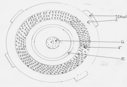
i) Name parts marked E, F and G.
E
F
G
ii) Name the minerals that make the crust.
(c) Give two dates in a year when the number of hours of daylight and darkness are equal.
5. (a) State two theories that have been put forward to explain the origin of the earth.
(b) The diagram below shows a set up of two thermometers use it to answer question (i) and (ii).
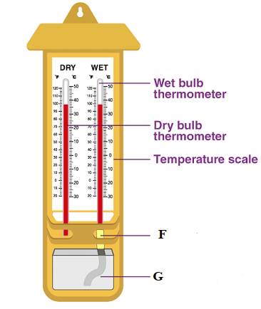
i) Which instrument is represented by the two thermometers?
ii) Name the parts labeled F and G
(c)The diagram below represents the structure of the atmosphere. Name parts labeled (3mks)
6. (a ) Identify three areas studied in human geography.
b) Explain four reasons why geography is studied in Tanzania schools.
(c) Name four subjects that relate with geography.
7. a) State three effects of earth’s rotation on its own axis
b) Use a well labeled diagram to show how a lunar eclipse occurs.
c) Explain three proofs that earth is spherical.
8. (a) Define weather
b) Name five elements of weather.
c) State three factors to consider when citing a weather station.
9. (a) Name three types of clouds’.
b) Name three instruments that are kept in the Stevenson’s screen.
c) The data below shows temperature of Arusha town recorded on 24/1/2014
Maximum Temperature 200C
Minimum Temperature 150C
- Calculate diurnal range of temperature for Arusha town.
- Calculate the mean daily temperature for Arusha town.
SECTION C: 15 MARKS
10. Discuss the main challenges facing livestock keeping in Australia
FORM TWO GEOGRAPHY EXAM SERIES 176
FORM TWO GEOGRAPHY EXAM SERIES 176
PRESIDENT’S OFFICE, REGIONAL ADMINISTRATION AND LOCAL GOVERNMENT
SECONDARY EXAMINATION SERIES,
MID TERM ONE – MARCH-2024
GEOGRAPHY FORM TWO
TIME 2HOURS
INSTRUCTIONS.
- This paper consists of section A, B and C with the total of ten (10) questions.
- Answer all questions in each section.
- Section A carries 15 marks, section B 70marks and section C carries 15marks
- All writing must be in blue or black ink.
- All answer must be written in the space provided to you.
- All communication devices, calculators and any unauthorized materials are NOT allowed in the examination room.
- Write your examination number on every page of your answer sheet(s)
SECTION A
- For each of the following items (i-x).Choose the best answer among the given alternatives given and writer it’s later beside the item number
- What is the position of earth from the sun?
- Second
- Third
- Fourth
- Last
- Last but one
- Seasons of the year are caused by
- The earth’s tilted axis and rotation
- The earth’s tilted axis and revolution
- Horizon of the earth
- Lunar eclipse
- When the earth’s shadow is cast over the moon’s surface , The phenomenon is known as ;
- Lunar eclipse
- Solar eclipse
- Summer solstice
- Equinoxes
- Which of the following is an example of Residual Mountain?
- Sekenke hills in Singida
- Kibo in Kilimanjaro
- Uluguru in Morogoro
- Usambara in Tanga
- Meru in Arusha
- The atmosphere is said to be most humidity only when
- Is saturated with water vapour
- Is unsaturated with water vapour
- Contains water vapour
- Does not contain water vapour
- Altitude influences ....................of a place
- Temperature
- Cloud and sunshine
- Humidity and precipitation
- Wind speed and direction
- The condition of the atmosphere over a short period is :
- Climate
- Meteorology
- Weather
- Precipitation
- The graph which shows both temperature and rainfall characteristic is called
- Bar graph
- Climograph
- Line graph
- Isograph
- Traditional livestock farming is practiced areas where there is :
- Very low rainfall
- Heavy rainfall
- No rainfall
- Dry land
- Large scale livestock farming is conducted in ;
- Ranches
- National parks
- Zero-grazing
- Urban areas
- Match the statement in list A with corresponding term in list B and write letter of correct answer on space provided
| LIST A | LIST B |
|
|
SECTION B
70 MARKS
Answer all questions
- King’oto village is surrounded by mountains. Most of its rainfall originated from those mountains.
- Name the possible type of rainfall in King’oto village
- Describe the type of rainfall named in (a)
- Illustrate the type of rainfall in King’oto village by using a well labeled diagram
- The local time of Tunis 100E is 3;00pm. What is the local time of Mombasa Kenya 400E?
- Define the following terms
- Plantation agriculture
- Mixed farming
- Nomadic pastoralism
- Ranching
- Zero-grazing
- There was heated exchange of words between Janet and John, on either the earth is flat or round. Help them solve conflicts by showing proof that earth is round
- Water is lie. No water no life.
- Justify the above statement by outlining four (4) points
- There are several human activities that affect sources of water. List at list three human activities that affect water sources.
- List down three ways of managing water resources.
- List down any five human activities that require geographical knowledge and skills
b) After studying geography we expect to obtain different job opportunities that can be obtained.
- Planet earth is composed of different land masses known as continents from which we can get different relief features , mention at least five of them
b) All land masses are surrounded by large body of salt water and ocean. Mention five of them.
SECTION C
15 MARKS
- You are invited by geography teacher of form one to explain to the class on importance of studying Geography. Use five points to do your task.
FORM TWO GEOGRAPHY EXAM SERIES 167
FORM TWO GEOGRAPHY EXAM SERIES 167
Student Assessment Number…………………………
PRESIDENT OFFICE REGIONAL ADMINISTRATION
AND LOCAL GOVERNMENT
SECONDARY EXAMINATION SERIES
COMPETENCE BASED ASSESSMENT
GEOGRAPHY FORM TWO
MID TERM EXAMS- 2023
013
Time 2.30 Hours AUG, 2023
INSTRUCTIONS
- This paper consists of section A,B and C with a total of ten (10) questions.
- Answer all questions
- Section A and C carry fifteen (15) marks each and section B caries seventy (70) marks
- All writings must be written in the space provided.
- Any unauthorized materials are not allowed in the assessment room
- Write your assessment number at the top right corner of every page.
SECTION A (15 MARKS)
Answer all questions
1. For each of the items (i) – (x), choose the correct answer from the given alternatives and write it’s letter in the box provided.
- In a group discussion, Mero told his fellow form two students that “ocean floor consists of numerous features”. Which one of the following groups of terms do you think mentioned by Mero as applicable to some parts of the ocean floor?
- Basin, deep, cirque, plateau
- Ocean ridge, ocean deep, deep sea plain, continental slope
- Sea trench, beach, basin, ridge
- Sea ridge, ocean deep, ocean basin, water falls
- The earth is constantly rotates and revolves while inclined on it’s axis. What does a permanent tilt of the earth axis and revolution of the earth in it’s orbit cause?
- Day and Night
- The deflection of winds
- Difference in time between places on different meridians
- Varying length of day and night at different times of the year
- Ms Kweka visited all tropical climatic regions. In her visits she observed great temperature variations among the regions. Which of the following tropical climate does Ms Kweka observed to have the largest diurnal temperature range?
- Equatorial climate
- Tropical monsoon
- Tropical savanna
- Hot desert
- The students of Nguvu Moja Secondary school visited the farmers at Mivinjeni village, at the village they observed the farmer cultivating using machines like tractors, what kind of agriculture was practiced by the farmer at Mivinjeni village?
- Bush fallowing
- Large scale agriculture
- Nomadic cultivation
- Small scale agriculture
- When the noon sun is directly overhead at the tropic of cancer (23.50N latitude) around 21 June in the northern hemisphere, the condition known as:
- Summer Solstice
- Spring Solstice
- Winter Solstice
- Autumn Solstice
- The temperature at Korogwe 950m is 24
 . What is the temperature of Kilimanjaro 5895m above the sea level?
- 5.670C
- 18.150C
- -5.670C
- 10.240C
- Suppose a meteorologist measured the temperature at Antananarivo 770F and convert it into degrees centigrade as 250 C. Which among the following formula a meteorologist used to convert from 0F to 0C?
- 0F = 9/5 (0C + 32)
- 0C = 9/5 (0F – 32)
- 0F = 5/9 ( 0C + 32)
- 0C = 5/9 (0F -32)
- A person may either gains or losses time when travels across international date line east or west respectively .Hence one gains in terms of time by 60 minutes for every 150 of longitude when travels from:
- North to South
- East to South
- West to East
- East to West
- There are so many imaginary lines drawn to explain the earth’s surface, some are vertical, horizontal and inclined. Which of the following statements best describes longitude?
- An imaginary line on the earth’s surface joining the north and south poles
- The angular distance east or west of the Greenwich meridian
- The distance of a place east or west of the Greenwich meridian
- The position of a place on the earth’s surface with reference of the prime meridian
- The tourists from Germany to Tanzania were interested to visit mountains formed by cooling and solidification of molten material. Which type of mountains will satisfy their interest?
- Residual Mountains.
- Block mountains
- Fold Mountains
- Volcanic mountains
2. Match the items in LIST A with the corresponding one in LIST B by writing the letter of the
correct response below the item number in the table provided.
| LIST A | LIST B |
|
|
| LIST A | i | ii | iii | iv | v |
| LIST B |
|
|
|
|
|
SECTION B (70marks)
Answer all questions
3. Dr .Katigile measured a bearing of Dodoma (NW) from Dar-es-salaam (SE) in Tanzania and read 3050NW of Tanzania at 11: 30 am
a) Out line four procedures used by Dr. Katigile to measure the bearing
i. ………………………………………………………………………………………………
ii. ………………………………………………………………………………………………
iii………………………………………………………………………………………………
iv. ………………………………………………………………………………………………
b) Name the type of bearing measured by Mr. Katigile
………………………………………………………………………………………
c) Show other possible ways that can be used to locate the position of a place
- ………………………………………………………………………………………………
- ………………………………………………………………………………………………
- ………………………………………………………………………………………………
- ………………………………………………………………………………………………
4. James family was watching TV at home; the program was a weather forecasting. James and his wife got angry with the program as they said weather forecasting is useless to them.
a) As a F II geography student helps James family to understand the importance of weather forecasting (Four points)
- ………………………………………………………………………………………………
- ………………………………………………………………………………………………
- ………………………………………………………………………………………………
- ……………………………………………………………………………………………
b) List at least two dangerous that a country will face when weather forecasting is not implemented
- ………………………………………………………………………………………………………………………………………………………………………………………………
- ………………………………………………………………………………………………………………………………………………………………………………………………
5 a) Draw a well labeled diagram to show the solar eclipse

b) Briefly describe on how the sun eclipse you have drawn above occurs
………………………………………………………………………………………………………
………………………………………………………………………………………………………
………………………………………………………………………………………………………
c) Give two impacts which may occur due to solar eclipse
- ………………………………………………………………………………………………………………………………………………………………………………………………
- ………………………………………………………………………………………………………………………………………………………………………………………………
6. A teacher at Ilulu Secondary School gave an assignment to FII students on identifying various energy resources both renewable and non – renewable energy resources. As one among Form II students
a) Mention any five (5) energy resources in the world.
- ………………………………………………………………………………………………
- ………………………………………………………………………………………………
- ………………………………………………………………………………………………
- ………………………………………………………………………………………………
- ………………………………………………………………………………………………
b) Give three (3) importance of renewable energy resources
- ………………………………………………………………………………………………………………………………………………………………………………………………
- ………………………………………………………………………………………………………………………………………………………………………………………………
- ………………………………………………………………………………………………………………………………………………………………………………………………
c) What are the two challenges facing the production and uses of non – renewable resources
- ………………………………………………………………………………………………
- ………………………………………………………………………………………………
7. In making a good map, scale is very important information to be considered. Without a scale map isincomplete:
a) With examples, outline three types of map scale
- ………………………………………………………………………………………………
- ………………………………………………………………………………………………
- ………………………………………………………………………………………………
b) In which ways the map scale can be expressed
- ………………………………………………………………………………………………
- ………………………………………………………………………………………………
- ………………………………………………………………………………………………
c) Give two importance of a map scale
- ................................................................................................................................................
- ………………………………………………………………………………………………
d) Suppose that one centimeter on the map represent a half Kilometer on the ground (1cm to ½ km), covert it into representative Fraction scale
………………………………………………………………………………………………………
………………………………………………………………………………………………………
………………………………………………………………………………………………………
………………………………………………………………………………………………………
………………………………………………………………………………………………………………………………………………………………………………………………………………………………………………………………………………………………………………………………………………………………………………………………………………………………………………………………………………………………………………………………………………………………………………………………………………………………………………………………………………………………………………………………………………………
8. A meteorologist gave the Form two students books to discuss about five climatic regions, In their reading and discussion they noted one among the five regions is located along 00 to 50 North and south of the equator.
a) What type of climatic region do the students noted being located from 00 to 50?
………………………………………………………………………………………………………
b) Where does the climatic region mentioned in (a) above distributed in the world?
………………………………………………………………………………………………………
……………………………………………………………………………………………………
………………………………………………………………………………………………………
c) Mention five climatic characteristics of the region mentioned in (a) above.
- ………………………………………………………………………………………………
- ………………………………………………………………………………………………
- ………………………………………………………………………………………………
- ………………………………………………………………………………………………
- ………………………………………………………………………………………………
d) What are the four dominant economic activities that are practiced in the climatic region mentioned (a) above
- ………………………………………………………………………………………………
- ………………………………………………………………………………………………
- ………………………………………………………………………………………………
- ………………………………………………………………………………………………
9. Mr Brown is an American investor, he just came from U.S.A and want to set up manufacturing industry in your country. He is now stress full since he don’t know where and how he will manage to establish industry. As a geographer
a) Out line five factors to assist Mr Brown to locate manufacturing industry in your country
- ………………………………………………………………………………………………
- ………………………………………………………………………………………………
- ………………………………………………………………………………………………
- ………………………………………………………………………………………………
- ………………………………………………………………………………………………
b) Give three (3) importance of manufacturing industry in the country
- ………………………………………………………………………………………………
- ………………………………………………………………………………………………
- ………………………………………………………………………………………………
c) List down two main challenges that hinder the development of manufacturing Industry
- ………………………………………………………………………………………………
- ………………………………………………………………………………………………
SECTION C (15marks)
Answer question ten (10)
10. “DAWASCO was the responsible medium for water supply and management in Dar-es –salaam. The sector helped the government acknowledging people on the importance and need for water management. Some people failed to understand. As an expert in the whole aspect of water, describe significances of water management for daily life
………………………………………………………………………………………………………………………………………………………………………………………………………………………………………………………………………………………………………………………………………………………………………………………………………………………………………………………………………………………………………………………………………………………………………………………………………………………………………………………………………………………………………………………………………………………………………………………………………………………………………………………………………………………………………………………………………………………………………………………………………………………………………………………………………………………………………………………………………………………………………………………………………………………………………………………………………………………………………………………………………………………………………………………………………………………………………………………………………………………………………………………………………………………………………………………………………………………………………………………………………………………………………………………………………………………………………………………………………………………………………………………………………………………………………………………………………………………………………………………………………………………………………………………………………………………………………………………………………………………………………………………………………………………………………………………………………………………………………………………………………………………………………………………………………………………………………………………………………………………………………………………………………………………………………………………………………………………………………………………………………………………………………………………………………………………………………………………………………………………………………………………………………………………………………………………………………………………………………………………………………………………………………………………………………………………………………………………………………………………………………………………………………………………………………………………………………………………………………………………………………………………………………………………………………………………………………………………………………………………………………………………………………………………………………………………………………………………………………………………………………………………………………………………………………………………………………………………………………………………………………………………………………………………………………………………………………………………………………………………………………………………………………………………………………………………………………………………………………………………………………………………………………………………………………………………………………………………………………………………………………………………………………………………………………………………………………………………………………………………………………………………………………………………………………………………………………………………………………………………………………………………………………………………………………………………………………………………………………………………………………………………………………………………………………………………………………………………………………………………………………………………………………………………………………………………
FORM TWO GEOGRAPHY EXAM SERIES 157
FORM TWO GEOGRAPHY EXAM SERIES 157
PRESIDENT OFFICE REGIONAL ADMNISTRATION
AND LOCAL GOVERNMENT
SECONDARY EXAMINATION SERIES
COMPETENCE BASED ASSEMENT
GEOGRAPHY FORM TWO
TERMINAL EXAMS-MAY – 2023
013
Time: 2:30 Hours
Instructions
- This paper consists of sections A, B and C with a total of ten (10) questions.
- Answer all questions.
- Section A and C carry fifteen (15) marks each and section B caries seventy (70) marks
- All writing must be in blue or black ink
- All writing must be written in the space provided.
- Cellular phones, calculators and any unauthorized materials are not allowed in the assessment room.
SECTION A (15 MARKS)
- For items (i) – (x) Choose the correct answer from alternative given and write its leer on spaces provided.
- Places on the east experience sunrise before the place of west because
- The earth rotates from west to east
- The earth rotates from east to west
- earth rotates from north to south
- The earth is closer to the sun
- Which type of mountains results of molten rocks from the earth interior?
- Volcanic mountain.
- Block mountain
- Residual mountain.
- Fold mountain
- What is the time at Lilongwe (40°w) when it is noon at Dodoma (33°E)
- 16:52pm
- 7:08am
- 7:08pm
- .10:52am
- The path used by the earth and other planet when going around the sun is called
- Axis
- Latitude
- galaxy
- Orbit
- Equal length of a day and night when the sun is overhead at the equator is known as
- Equinox
- Solstice
- Summer
- Perihelion
- Which scale is used to draw a map of large area? ( )
- large scale.
- small scale.
- Medium scale
- simple scale
- The nearest planet on the solar system from the sun .
- Mars
- Neptune
- Earth.
- Mercury
- Which water body contains salt water among the following water bodies.
- Lake Victoria.
- Lake Nyasa.
- .Indian Ocean
- Lake Tanganyika
- Which things important in map drawings
- Margin, Key,scale and R.F scale
- Key, scale,tilltle and date of publication
- Scale,frame, tilltle and linear scale
- linear scale,small scale, large scale and medium scale
- Why Stevenson screen is painted white color
- To prevent the sun's heat to reach inside
- To avoid from the dangerous animals. ( )
- To predict weather through observation
- To keep instruments which used measure elements of weather
- Match the items in List A with responses in List B by writing the letter of the correct response below the corresponding item number in the table provided:
| LIST A | LIST B |
|
|
| List A | i | ii | iii | iv | v |
| List B |
|
|
|
|
|
- The table below shows temperature readings at a weather station for one week. calculate the following
| Temp/day | Mo | Tue | Wed | Thu | Fri | Sat | Su |
| Max 0C | 28 | 27 | 28 | 26 | 29 | 29 | 26 |
| Min 0C | 18 | 18 | 20 | 16 | 22 | 21 | 19 |
- Calculate the diurnal range of temperature for Tuesday
- The Mean temperature for Saturday
- Outline five uses of solar energy.
- …………………………………………………………………………………………………………………………….
- …………………………………………………………………………………………………………………………….
- …………………………………………………………………………………………………………………………….
- ……………………………………………………………………………………………………………………………
- ……………………………………………………………………………………………………………………………
- (a) Mention three ways used to express scale of the map
(b)Why cartographer advised to use scale when they decided to draw a map. 3 points
(c) Juma is a lorry driver, he uses map when he travel across the boarders.
What is the importance of map apart from driving . 4 points
- Define the followings terms
- Subsistence farming ____________________________________________________________________________________________________________________________________________________________________________________________________________________________________________________________________________________
- Mixed farming ____________________________________________________________________________________________________________________________________________________________________________________________________________________________________________________________________________________
- Monoculture ____________________________________________________________________________________________________________________________________________________________________________________________________________________________________________________________________________________
- Primary activities ____________________________________________________________________________________________________________________________________________________________________________________________________________________________________________________________________________________
- Secondary activities ____________________________________________________________________________________________________________________________________________________________________________________________________________________________________________________________________________________
- Outline five (5) differences between weather and Climate
………………………………………………………………………………………………………………………………………………………………………………………………………………………………………………………………………………………………………………………………………………………………………………………………………………………………………………………………………………………………………………………………………………………………………………………………………………………………………………………………………………………………………………………………………………………………………………………………………………………………………………………………………………………………………………………………………………………………………………………………………………………………………………………………………………………………………………………………………………………………………………………………………………………………………………………………………………………………………………………………………………………………………………………………………………………………………………………………………………………………………………………………………………………………………………………………………………………………………………………………………………………………………………………………………………………………………………………………………………………………………………………………………………………………………………………………………………………………………………………………………………………………………………………
- List down five resources obtained from Forests
i ........................................................................................................................................................
ii. ......................................................................................................................................................
iii. .......................................................................................................................................................
iv. .......................................................................................................................................................
- ........................................................................................................................................................
- Define the following geographical terminologies
(a)Aphelion (b)Umbra (c)Great circle (d)Meteors
SECTION C (15 Marks)
Choose any one question.
- Explain how East African countries benefited from mining sector. Give six points
- About three quarters of households in sub-Saharan Africa get water from sources located away from their homes, with women and girls bearing the main task of collecting water for their respective households. Elaborate six effects of distance to water sources on the girl-child in Tanzania
FORM TWO GEOGRAPHY EXAM SERIES 146
FORM TWO GEOGRAPHY EXAM SERIES 146
PRESIDENT OFFICE REGIONAL ADMINISTRATION AND LOCAL GOVERNMENT
SECONDARY EXAMINATION SERIES
COMPETENCE BASED ASSESSMENT
013 GEOGRAPHY FORM TWO
MID-TERM EXAMS-MARCH – 2023
Time: 2:30 Hours
Instructions
- This paper consists of sections A, B and C with a total of ten (10) questions.
- Answer all questions.
- Section A and C carry fifteen (15) marks each and section B caries seventy (70) marks
- All writing must be in blue or black ink
- All writing must be written in the space provided.
- Cellular phones, calculators and any unauthorized materials are not allowed in the assessment room.
SECTION A
Answer all Questions
1. For each of the items (i) – (x). Choose the correct answer from given alternatives and write its letter in the box provided.
- Farmers may decide to move to new farm after experience decrease in crops, yield. What do we call this farming method?
- Bush following
- Crop rotation
- Shifting cultivation
- Trip method
- What type of rainfall occurs when warm moist wind from the ocean is forces to rise up by mountain?
- Orographic rainfall
- Conventional Rainfall
- Frontal rainfall
- Cyclonic Rainfall
- Joti and Jeki were required to calculate a distance of a road on a map provided. Which possible method could they use?
- Tracing method
- Strapping method
- A pair and divides
- Division method
- A list of Mountains in provided to students, it consists of Vosges, Black forest, and Sinai mountains. These mountains belong to which category?
- Horst mountain
- Volcanic mountain
- Fold mountain
- Residual mountain
- Assume that you have been assigned to draw a map showing areas experiencing the same amount of rainfall, which line would you choose to indicate those areas?
- Isobars
- Isohyets
- Isotherms
- Isohyt
- Quarrying, hunting fishing and lumbering is called
- Secondary activities
- Tertiary activities
- Quaternary activities
- Primary activities
- Which one is an economic importance of livestock keeping in Tanzania?
- Keeping small number of animal
- Source of government Revenue
- Keeping large number of animal in non-productive land
- Reducing animal diseases
- The difference in time between Accra in Ghana and Bujumbura in Burundi is 2hours. What is the longitudinal distance between the two towns
- 15°
- 08°
- 30°
- 60°
- Which set among the following shows the long term observation of a climate of a place?
- Precipitation, humidity, temperature, wind
- Wind, Air-mass, mist, flog, temperature
- Mist, dew point, wild speed, wind direction
- Wind direction, Precipitation, humidity, and air-mass
- What are basic components of a map?
- Title, key, compass, direction, margin, scale
- Conversion table, North direction, contour, key
- Topography, map scale, key, margin
- Grid north, True north, Magnetic North
2. Match the description of bodies of solar system in List A with correct solar system body in List B by writing the letter of correct response below corresponding item number in table provided.
| LIST A | LIST B |
|
|
SECTION B (70 marks)
Answer all questions
3. John was watching a match between Taifa stars and Morocco on a Television which Avan played in Rabat Morocco (10°) at 3:00p.m
- What will be a local time of John who is watching the match in Tanga at 40°E?
- Mention the name of the time when the match was watched
- Describe other possible time which might be recorded in the are
4. Suppose you have been invited by villagers in SONI village to teach them on how they can extract the mineral discovered in their village which in brownish black in colour, and is made of organic substances deposited for long time
- Identify possible mineral discovered in the village
- Outline three uses of mineral discovered in Sons village
- Describe three problems limiting exploitation of mineral which were discovered in Soni village.
5. Carefully study the climate data of station X then answer questions that follow.
| Month | J | F | M | A | M | J | J | A | S | O | N | D |
| Temp °C | 23 | 22 | 21 | 19 | 16 | 14 | 13 | 15 | 18 | 18 | 17 | 14 |
| Rainfall mm | 19 | 14 | 24 | 41 | 92 | 118 | 93 | 55 | 51 | 46 | 24 | 98 |
- Suggest type of Climate in station X. Give two strong endence to support your answer
- Give four characteristic of type of climate suggested above
- With examples, give three common activations undertaken under climate of station X
6. Kivalwa is a village where by villages work long distance to fetch water, how does distance to water point after girl child?
7. Differentiate between the following terms as used in Geography
- Small holder former and substance forming
- Connate water and Juvenile water
- Adit mining and panning method
- Footloose industries and industrial inertia
- Shooting star and meteorite
8. (a)Geography can be defined as the study of distribution and interrelationship of phenomena in relation to earth’s surface. Briefly explain how geography relates with
(i) Biology (ii) Commerce
(b) Explain the economic importance of studying geography
9. Explain four (4) importance of human activities
SECTION C (15 Marks)
Answer question ten (10)
10. A government is struggling is ensure that women are participating in small scale Agriculture the officers concerned do not know how to empower women so as they can participate fully, which ways will you suggest to accomplish a plan?
FORM TWO GEOGRAPHY EXAM SERIES 134
FORM TWO GEOGRAPHY EXAM SERIES 134
THE PRESIDENT’S OFFICE
REGIONAL ADMINISTRATION AND LOCAL GOVERNMENT
COMPETENCY BASED EXAMINATIONS
FORM TWO PRE-FTNA ASSESSMENTS
GEOGRAPHY
CODE: 013
TIME: 2:30 Hours October ,2022
INSTRUCTIONS
- This paper consist of section A, B and C
- Answer all question in section A.B and C
- Answer all questions in the space provided
- Cellular phoned, calculators and any computerized materials are not allowed in the examination room.
- All writing must be in blue /black ball pen except drawings which must be in pencil
- Write your examination number at the top right corner of every page
SECTION A (15 marks)
Answerallquestionfromthissection
- For each of the items (i) – (x), choose the correct answer from among the given alternatives and write its letter in the box provided.
- Each planet takes a different amount of time to take one orbit around the sun, because ;
- Their size vary from each other
- Their orbits are elliptical
- They are arranged in series
- Their distance from the sun vary
- The distance between two crest of water wave is referred tom
- Anticline
- Syncline
- Trough
- Wavelength
- Pastoralism where animal are given feeds in sheds without making them to go out in the field is known as;
- Zero grazing
- Nomadic pastoralism
- Mixed pastoralism
- Ranching
- The temperature at Moshi 950m is 24oC .What will be the temperature at Uhuru Peak 5895m above the sea level?
- 5.67oC
- −8oC
- −24oC
- 18oC
- Which one of the following instrument is not the component of a weather station?
- Rain gauge
- Wind vane
- Microscope
- Stevenson screen
- The time which is recorded along the same meridian is called?
- Local mean time
- Greenwich mean time
- Great mean time
- Standard time
- Which scale is the largest among the following;
A. 1:25,000
B. 1:1,1500,000
C. 1:50,000
D. 1:10,000
- A someone ascends in altitude ,the temperature tends to;
- Decrease and increase
in time
- Decrease at the rate of 0.6
FORM TWO GEOGRAPHY EXAM SERIES 130
FORM TWO GEOGRAPHY EXAM SERIES 130
Student's Assessment
THE PRESIDENT’S OFFICE
REGIONAL ADMINISTRATIVE AND LOCAL GOVERNMENT
FORM TWO EXAMINATIONS SEPTEMBER 2022
NEW NECTA FORMAT
GEOGRAPHY
TIME: 2:30 Hours
![]()
Instructions
- This paper consists of section A, B and C with a total often (10) questions.
- Answer all questions in section A and B and section C.
- All writing must be in blue of black ink.
- All answers must be written in the space provided.
- Cellular phones, calculator and any unauthorized materials are not allowed in the examination room.
- Write your examination number at the top right corner of every page.
SECTION A (15 MARKS)
Answer all questions in this section.
1. For each of the items (i) — (x), choose the correct answer from among the given alternative and write its letter in the box provided.
i.When the spring equinox does occurs?
- 3 rdJanuary
- 23 rdSeptember
- 21 st march
- 4th July ii.
- The stretch of land where standard time is accepted throughout a longitudinal zone 15 0 in width.
- Time zone
- Greenwich mean time
- Standard time
- Prime meridian time
- Deflection of wind and daily rising and falling of tides are among the
effects of?
A. Earth's movement B. Earth's rotation
- Earth's revolution
- Aphelion and perihelion
iv. Ocean water occupies about …... . Percent of the earth's surface,
A. 21
B. 29
C. 71
D .70
- The streams that join together to form main streams.
- Distributaries
- Drainage
- Tributaries
- River basin
- If the temperature at dare s salaam which is at sea level is 320c, what will be the temperature at a place where altitude is 1,500meters?
- 0.60c
- 230c
- 90c
- D. 41 0c
- Dormant volcanic mountains are those which
A. Have never experienced eruptions.
- Have erupted once but are no longer active
- Continue to erupt occasionally
- Erupt when there is an earth quake
- The region which found between 50 and 200 North and South of Equator
- Savanna grassland
- Equatorial region
- The hot deserts
- Mediterranean climate
- If the temperature of station X is 1040F, What is the temperature of the same station in 0C.
- 420C
- 360C
- 21 0C
- 400C
(x) Isohyets are the lines on a map which join all places with the same
- Height above the sea level
- Amount of rainfall
- Atmospheric pressure
- . Natural vegetation
- Match the items in List A with responses in List B by writing the letter of the correct response below the corresponding item number in the table provided.
| List Å | List B | ||||||
| i. Rocks which allows water to pass through ii. Water which originates from precipitation such as snowfall iii. Water from greater depths of earth's surface as a result of volcanic activity iv. The rocks which have pores through which water can filtrate v. Salt extraction, fishing, sand, seaweeds and decorative items such as corals and sea shells |
| ||||||
| List A | 1 | 11 | 111 | iv | v | ||
| List B | |||||||
SECTION B (70marks)
Answer all questions in this section
- In each of the following items (i-x ), write TRUE if the statement is correct or FALSE if the statement is not correct.
- The moon takes 31 days to make a complete revolution round the earth.
- The generation and distribution of electric power in Tanzania is done by DAWASCO.
- Isokinetic is the lines on the map joining places with the same wind movements..
- Altitude, latitude and ocean current are the factors that affect temperature..
- Topographical maps used to express descriptive information such as pressure, temperature and crops..
- The differences between weather and climate based on time and area covered..
- Always stream channel carries more water in Morogoro region during the dry seasons
- The planets are called wandering stars in Greek………………..
- Coal, petroleum, oil, natural gas and wind are examples of nonrenewable resources...
- Pipelines transport is suitable for carrying water, petroleum and gas.
- (a) List down five techniques used in land reclamation
(b) Briefly explain three major types of rainfall
(c) Give out four sources of water pollution.
(d)Naturally we believe that the earth rotates on its axis from west to east in an anticlockwise direction through 3600 with examples describe the evidences that prove that the earth rotates from west to east. Give three points.
5. (a) Define the term climate change.
(b) Give three human causes of climate change
(c) Briefly describe the impacts of climate change to physical and human environment. Give five
7. (a) What are the values of scale to the map users? Gives three
- Which methods can be used to locate position of a place on the map? Mention four.
- The distance of the road from Ifakara to Mang’ula is 38 cm. convert the distance in kilometer if the scale used is 1:50000.
- Why do you study maps? Give two reasons
- A large scale, medium scale and small scale maps all are the types of map scale.
With examples explain how they are distinguished by one to another. Give two reasons.
8. The Form Two students 'Were very happy to visit a place where a process of extracting valuable geological substance from the crust was taking place.
(a) How is the process taking place in the area called?
(b) List three possible types of valuable geological substance found in the area.
(c) Describe three main methods of extracting those valuable geological substances in the area.
(d) Outline five possible environmental hazards caused by the process taking place in the area
9. Elaborate five differences between heavy industries and light industries.
SECTION C (15 Marks)
10. Describe six consequences of water shortage to the communities.
FORM TWO GEOGRAPHY EXAM SERIES 117
FORM TWO GEOGRAPHY EXAM SERIES 117
THE PRESIDENT’S OFFICE
MINISTRY OF EDUCATION, REGIONAL ADMINISTRATION AND LOCAL GOVERNMENT
COMPETENCE BASED SECONDARY EXAMINATION SERIES
ANNUAL EXAMINATION
FORM TWO
GEOGRAPHY
013
TIME: 2:30 HOURS May , 2022
![]()
Instructions
1. This paper consists of sections A, B and C.
2. Answer all questions from sections A and B and any two (2) questions from section C.
3. Section A carries twenty five (25) marks, section B forty five (45) marks and section C carries thirty (30) marks.
4. All answers must be written in the spaces provided.
5. All writings must be in blue or black ink except for drawings which must be in pencil.
6. All communication devices, calculators and any unauthorized materials are not allowed in the Examination Room.
7. Write Your Examination Number on the top right of every page.
SECTION A (25 Marks)
Answer all questions in this section.
1. Each of the items (i) - (x), choose the correct answer from the given alternatives and write its letter in the space provided.
(i) What are the basic components of a map?
- Title, key, compass direction, margin and scale
- Conversion table, north direction, contour and key
- Topography, map scale, key and margin
- Grid north, true north and magnetic north
(ii) The following are the measures to improve small scale agriculture in Tanzania except;
- provision of soft loans for improved investment in agriculture.
- encouraging famers to adopt plantation agriculture in rural areas.
- educating farmers on good farming techniques.
- establishment of cooperatives that can assist farmers.
(iii) A scale of the map which is expressed as one centimeter on the map represents one kilometer on ground is called
- Representative fraction
- Linear scale
- Linear scale
- Small scale
(iv) Which set among the following shows the long-term observations of a climate of a place?
- Precipitation, humidity, temperature and wind
- Wind, air-mass, mist, fog and temperature
- Mist, dew point, wind speed and wind direction
- Wind direction, precipitation, humidity and air-mass
(v) Cultivation of cash crops based on application of advanced technology is called?
- Subsistence agriculture
- A large scale agriculture
- Mixed system agriculture
- A small scale agriculture
(vi) When does the summer solstice in the southern hemisphere occurs?
- 21st June
- 23rd September
- 21st September
- 22nd December.
(vii) Time increases by 4 minutes for every 1 ![]() of longitude when one travels from
of longitude when one travels from
- North to South
- East to South
- West to South
- West to East.
(viii)Which type of mountains results from the eruption of molten rocks from the earth interior?
- Volcanic mountains
- Block mountains
- Residual mountains
- Fold mountains
(ix)Which type of climate among the following is different from the other?
- Mediterranean
- Savanna
- Hot desert
- Equatorial
(x)Which one of the following features are correct set of the ocean floor?
- Ridge, basin, plateau and waterfall.
- Continental shelf, basin and waterfall.
- Trench, continental shelf and continental slope.
- Horst, plain and volcano.
2. Match the items in List A with responses in List B by writing the letter of the correct response below the corresponding item number in the table provided.
| LIST A | LIST B |
|
|
3 .In each of the following items (i) - (x), write TRUE if the statement is correct or FALSE if the statement is not correct.
(i)Ocean trenches are also known as submarine plateaus ....
(ii)Equator is not the Great Circle ...
(iii)An eclipse is described as partial when only a part of heavenly body is obscured .........
(iv)Maximum thermometer records both maximum temperature with a day........
(v)Grid reference and bearing are used to determine the position of a place on a map ....
(vi)A scale helps map interpreters to calculate distance, area and computation of other facts....
(vii)Ocean currents are set in motion by prevailing winds .........
(viii)Juvenile water is also referred as underground water .........
(ix)Circumnavigation of the earth is not among the evidence to prove that the earth is spherical......
(x)Uncontrolled deforestation does not expose soil to erosion and extinction of fauna and flora species ..„.
SECTION B (45 Marks)
Answer all questions in this section.
4. The students were watching a video program showing the earth's surface in Tanzania which was irregular. Difference in altitudes and slope give rise to different features and human activities observed in the video program.
(a) Outline five possible features observed by the students.
(b) By giving an example, mention major types of water bodies observed.
(c) Give an example of the main natural basin on the earth's surface observed by the students in the video program
(d) Name four possible types of a large and elevated part of the earth's surface that rise from greater height the students observed.
5. (a) Outline five economic resources which are obtained from water bodies
(i) ………… …………… ………………… ……………
(ii) …………… ……………… ……………… …………
(iii) ………… …………… …………… ……………
(iv) …………… …………… …………… …………… …
(b) Mention five ways of conserving water resources
(i) ………… …………… …………… …………… ……………
(ii) ………… …………… …………… …………… ……………
(iii) …………… …………… …………… …………… ……………
(iv) …………… ……………… ……………… ………………
(v) ……………… ……………… ……………… ………………
(c) List five major means of transport on land.
(i) …………… …………… …………… …………… ……………
(ii) ……………… ……………… ……………… ………………
(iii) ……………… ……………… ……………… ………………
(iv) ……… …… ……………… ………… ……………… …………
(v) …………… …………… …………… …………… ……………
5. Study the sketch map provided and answer the questions that follow:
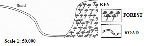
- Name the type of scale which has been used to represent this map.
- Mention three ways which can be used to measure the distance of the road in the sketch map.
- Briefly describe three important basic components of a map.
- Convert the given scale into a statement.
- Mention three methods which can be used to calculate the area of the forest shown on the sketched map.
SECTION C (30 Marks)
Answer two (2) questions from this section.
7. Elaborate five problems facing the development of mining industry in Tanzania.
8. Explain five measures which can be taken to ensure the sustainability of forests in Tanzania.
9. Write a short essay about problems which face the development of the transport sector in Tanzania.
10. What are the negative results of tourism in Tanzania?
FORM TWO GEOGRAPHY EXAM SERIES 98
FORM TWO GEOGRAPHY EXAM SERIES 98
PRESIDENT’S OFFICE
REGIONAL ADMINISTRATION AND LOCAL GOVERNMENT
MID TERM ONE EXAMINATIONS
GEOGRAPHY FORM TWO
013
TIME: 2:30 HOURS MARCH 2022
![]()
Instructions
1. This paper consists of sections A, B and C.
2. Answer all questions from sections A and B and any two (2) questions from section C.
3. Section A carries twenty five (25) marks, section B forty five (45) marks and section C carries thirty (30) marks.
4. All answers must be written in the spaces provided.
5. All writings must be in blue or black ink except for drawings which must be in pencil.
6. All communication devices, calculators and any unauthorized materials are not allowed in the Examination Room.
7. Write Your Examination Number on the top right of every page.
| FOR EXAMINER’S USE ONLY | ||
| QUESTION NUMBER | SCORE | EXAMINER’S INITIALS |
| 1 |
|
|
| 2 |
|
|
| 3 |
|
|
| 4 |
|
|
| 5 |
|
|
| 6 |
|
|
| 7 |
|
|
| 8 |
|
|
| 9 |
|
|
| 10 |
|
|
| TOTAL |
|
|
| CHECKER’S INITIALS |
| |
SECTION A: (25 Marks)Answer all questions in this section
1. Each of the items (i) - (x), choose the correct answer from the given alternatives and write its letter in the space provided.
(i) Branch of Geography dealing with field study, statistics, mapping and surveying is called:
A. Physical geography
B. Human and economic geography
C. Practical geography
D. Environmental geography.
(ii) When the Earth is at its aphelion in early July, the distance from the sun is about:
A. 500,000,000 km
B. 5,500,000 km
C. 4,800,00 km
D. 1,500,000 km.
(iii) The amount of humidity existed in air is measured by instrument called:
A. Barometer
B. Hygrometer
C. Hydrometer
D. Agrometer.
(iv) In temperature regions of the world life in mountain and plateau areas is difficult due to:
A. There is high temperature throughout the year
B. There is thin soils, cool climate and difficult and communication
C. There is heavy wild animals and high rainfall
D.There is no efficient power and water supply.
(v) The map of school compound or small village is drawn to:
A. Large scale
B. Small scale
C. Medium scale
D. Secondary section of the scale.
(vi) Quarrying, hunting, fishing and lumbering is referred to:
A. Secondary activities
B. Tertiary activities
C. Quaternary activities
D. Primary activities.
(vii) In Africa most farmers leave idle the exhausted piece of land for a certain period of time in order to regain its fertility, this agricultural technique is called:
A. Bush fallowing
B. Shifting cultivation
C. Sedentary farming
D. Aquaculture.
(viii) Africa has potential river development projects which are multipurpose schemes, since they provide irrigation schemes, flood control, water supply in both industries and domestic and Hydro Electrical power generation centres.The following are prominent H.E.P centres of East Africa, except:
A. Kihansi and Owen falls
B. Nyumba ya Mungu and Inga dams
C. Hale and Mtera dams
D. Kidatu and Seven forks in Tana river
(ix) Which sequence of the following processes is necessary for the formation of rainfall?
A. Condensation, cooling and evaporation
B. Evaporation, cooling and condensation
C. Evaporation, sedimentation and cooling
D. Evaporation, condensation and cooling.
(x) What is compass bearing of WNW?
A. 270o
B. 337o
C. 315o
D. 327o
2. Match each item in LIST A with responses in LIST B by writing the letter of the correct response below the corresponding item number in the table provided:
| LIST A | LIST B |
| (i) Are continuous stretches of comparatively flatland not rising much above sea level (ii) Is a major landmass rising from the ocean floor (iii) Extensive high altitude areas with more or less uniform summit levels (iv) Is a form of natural or artificial depression or hollow varying in size on the Earth’s surface. (v) Long narrow depression or trough in the central part formed between two parallel faults | A. Continent B. Mountain C. Basin D. Crater E. Plains F. Rift valley G. Plateau |
Answers:
| LIST A | (i) | (ii) | (iii) | (iv) | (v) |
| LIST B |
|
|
|
|
|
3. In each of the following items (i) – (x), write True if the statement is correct or False if the statement is not correct.
(i) All meridians and the equator form great circle. .............................................
(ii) Ranching is a practice of rearing livestock with the aim of not producing meat, milk, wool and hides for commercial purposes. _
(iii) The moon appears to rise in the East and set in the West because the earth spins from West to East.
(iv) Sea Breeze occurs during the day because sea water creates high pressure region in contrast to the land which develops low pressure during the day time.
(v) Large scale livestock farming is also known as zero grazing.
(vi) A map showing distribution of natural and manmade features is known as topographical map.
(vii) Exploitation of natural gases in Tanzania is only done by public companies.
(viii) The desert conditions are characterized by scanty vegetation and rainfall.
(ix) Air transport is not affected by adverse weather conditions.
(x) The flow of water over the ground is known as run-off.
SECTION B: (45 Marks)
Answer all questions in this section
4.(a) “Geography” can be defined as the study of the distribution and interrelationship of phenomena in relation to the earth’s surface. Briefly explain how geography relates with:
(i) Biology
4. (ii) Commerce
(b) Explain the economic importance of studying geography:
(i) ................................................................................................................................
(ii) ...............................................................................................................................
(iii) ............................................................................................................................
(iv) ............................................................................................................................
(v) ..............................................................................................................................
5. Carefully study the climatic characteristics of station X and answer the equations that follow:
Climatic characteristics:
• Annual range of temperature is very small about 2oC.
• Total rainfall ranges form 1500mm to 3,000mm per year with no distinct dry season.
• The type of rainfall is convectional rainfall accompanied by lightening and thunderstorms.
• High humidity through the year.
QUESTIONS:
(i) Identify the type of climate in station X. ____________________________ (ii) List any three (3) crops which can be grown in station X.
(a) ________________________________________________________
(b) ________________________________________________________
(c) ________________________________________________________
5. (iii) In which part of Africa this climate is found?
(a) ___________________________________________________________
(b) __________________________________________________________ (iv) Mention two (2) main economic activities taking place in this station:
(a) ______________________________________________________________
(b) ______________________________________________________________
6. Study carefully sketch map of MAFIGA provided and answer the questions that follow:

MAP OF MAFIGA:
6. (a) Calculate are covered by Lake Sutlej in kilometer square
_______________________________________________________________
_______________________________________________________________
_______________________________________________________________
_______________________________________________________________
(b) Measure the length of road from point A to point B. (Answer in km)
_______________________________________________________________
_______________________________________________________________
_______________________________________________________________ _______________________________________________________________
_______________________________________________________________
(c) Mention two (2) economic importance of the feature found eastern side of the map:
(i) ________________________________________________________
(ii) ______________________________________________________________
(d) Identify the feature found at grid reference 750130:
The feature is
_______________________________________________________________
_______________________________________________________________
(e) Name two (2) man made features shown on a map.
(i) ________________________________________________________
(ii) ________________________________________________________
SECTION C: (30 Marks)Answer two (2) questions in this section
7. The types of human activities are always related to the type of settlement. Elaborate four
(4) importance of human activities.
8. Explain why electricity is preferable source of power than fuel wood (Give five points)
9. Suggest any four (4) ways in which the tourism sector can be used to generate more income in Tanzania.
10. Outline five (5) ways of reducing industrial pollution in the world.
___________________________________________________________________________ ___________________________________________________________________________
___________________________________________________________________________
___________________________________________________________________________ ___________________________________________________________________________ ___________________________________________________________________________
___________________________________________________________________________ ___________________________________________________________________________ ___________________________________________________________________________ ___________________________________________________________________________ ___________________________________________________________________________ ___________________________________________________________________________
___________________________________________________________________________ ___________________________________________________________________________ ___________________________________________________________________________
___________________________________________________________________________
___________________________________________________________________________ ___________________________________________________________________________ ___________________________________________________________________________
___________________________________________________________________________ ___________________________________________________________________________ ___________________________________________________________________________
___________________________________________________________________________ ___________________________________________________________________________ ___________________________________________________________________________
___________________________________________________________________________
___________________________________________________________________________ ___________________________________________________________________________ ___________________________________________________________________________
___________________________________________________________________________ ___________________________________________________________________________ ___________________________________________________________________________
___________________________________________________________________________
___________________________________________________________________________ ___________________________________________________________________________ ___________________________________________________________________________ ___________________________________________________________________________ ___________________________________________________________________________
___________________________________________________________________________
___________________________________________________________________________ ___________________________________________________________________________ ___________________________________________________________________________
___________________________________________________________________________ ___________________________________________________________________________ ___________________________________________________________________________
___________________________________________________________________________
___________________________________________________________________________
___________________________________________________________________________
___________________________________________________________________________
___________________________________________________________________________ ___________________________________________________________________________ ___________________________________________________________________________
___________________________________________________________________________ ___________________________________________________________________________ ___________________________________________________________________________
___________________________________________________________________________
___________________________________________________________________________ ___________________________________________________________________________ ___________________________________________________________________________
___________________________________________________________________________ ___________________________________________________________________________
___________________________________________________________________________
___________________________________________________________________________ ___________________________________________________________________________ ___________________________________________________________________________
___________________________________________________________________________ ___________________________________________________________________________ ___________________________________________________________________________
___________________________________________________________________________
___________________________________________________________________________
___________________________________________________________________________
___________________________________________________________________________
___________________________________________________________________________ ___________________________________________________________________________ ___________________________________________________________________________
___________________________________________________________________________ ___________________________________________________________________________ ___________________________________________________________________________
___________________________________________________________________________
___________________________________________________________________________ ___________________________________________________________________________
___________________________________________________________________________
FORM TWO GEOGRAPHY EXAM SERIES 90
FORM TWO GEOGRAPHY EXAM SERIES 90
THE PRESIDENT�S OFFICE
MINISTRY OF EDUCATION, REGIONAL ADMINISTRATION AND LOCAL GOVERNMENT
COMPETENCE BASED �SECONDARY EXAMINATION SERIES
ANNUAL �EXAMINATION
FORM TWO
� � � � GEOGRAPHY
� � � �013 � � � � � � � � � � � � � � � � � � � � � � � �
TIME: 2:30 HOURS � � � � � � � � � � � � � � � � � � � � � � � � � � � � November, 2021
![]()
Instructions
1.This paper consists of sections A, B and C.
2.Answer all questions from sections A and B and any two (2) questions from section C.
3.Section A carries twenty five (25) marks, section B forty five (45) marks and section C carries thirty (30) marks.
4.All answers must be written in the spaces provided.
5.All writings must be in blue or black ink except for drawings which must be in pencil.
6.All communication devices, calculators and any unauthorized materials are not allowed in the Examination Room.�
7.Write Your Examination Number on the top right of every page.
| FOR EXAMINER�S USE ONLY | ||
| QUESTION NUMBER | SCORE | EXAMINER�S INITIALS |
| 1 | ||
| 2 | ||
| 3 | ||
| 4 | ||
| 5 | ||
| 6 | ||
| 7 | ||
| 8 | ||
| 9 | ||
| 10 | ||
| TOTAL� | ||
| CHECKER�S INITIALS | ||
SECTION A: (25 Marks)
Answer all questions in this section
1.Each of the items (i) - (x), choose the correct answer from the given alternatives and write its letter in the space provided.
(i)Branch of Geography dealing with field study, statistics, mapping and surveying is called:
A.Physical geography
B.Human and economic geography
C.Practical geography�
D. Environmental geography.
(ii)When the Earth is at its aphelion in early July, the distance from the sun is about:
A.500,000,000 km
B.5,500,000 km
C.4,800,00 km�
D. 1,500,000 km.
(iii)The amount of humidity existed in air is measured by instrument called:
A.Barometer
B.Hygrometer
C.Hydrometer
D.Agrometer.
(iv)In temperature regions of the world life in mountain and plateau areas is difficult due to:
A.There is high temperature throughout the year
B.There is thin soils, cool climate and difficult and communication
C.There is heavy wild animals and high rainfall D.There is no efficient power and water supply.
(v)The map of school compound or small village is drawn to:
A.Large scale
B.Small scale
C.Medium scale
D.Secondary section of the scale.
(vi)Quarrying, hunting, fishing and lumbering is referred to:
A.Secondary activities
B.Tertiary activities
C.Quaternary activities
D.Primary activities.
(vii)In Africa most farmers leave idle the exhausted piece of land for a certain period of time in order to regain its fertility, this agricultural technique is called:
A.Bush fallowing
B.Shifting cultivation�
C. Sedentary farming
D. Aquaculture.
(viii)Africa has potential river development projects which are multipurpose schemes, since they provide irrigation schemes, flood control, water supply in both industries and domestic and Hydro Electrical power generation centres.The following are prominent H.E.P centres of East Africa, except:
A.Kihansi and Owen falls
B.Nyumba ya Mungu and Inga dams
C.Hale and Mtera dams
D.Kidatu and Seven forks in Tana river
(ix)Which sequence of the following processes is necessary for the formation of rainfall?
A.Condensation, cooling and evaporation
B.Evaporation, cooling and condensation
C.Evaporation, sedimentation and cooling
D.Evaporation, condensation and cooling.
(x)What is compass bearing of WNW?
A.270o�
B. 337o�
C. 315o
D. 327o
2.Match each item in LIST A with responses in LIST B by writing the letter of the correct response below the corresponding item number in the table provided:
| LIST A | LIST B |
| (i)Are continuous stretches of comparatively flatland not rising much above sea level� (ii)Is a major landmass rising from the ocean floor (iii)Extensive high altitude areas with more or less uniform summit levels� (iv)Is a form of natural or artificial depression or hollow varying in size on the Earth�s surface. (v)Long narrow depression or trough in the central part formed between two parallel faults | A.Continent B.Mountain C.Basin D.Crater E.Plains F.Rift valley� G.Plateau |
Answers:
| LIST A | (i) | (ii) | (iii) | (iv) | (v) |
| LIST B |
3.In each of the following items (i) � (x), write True if the statement is correct or False if the statement is not correct.
(i)All meridians and the equator form great circle. ____________________________
(ii)Ranching is a practice of rearing livestock with the aim of not producing meat, milk, wool and hides for commercial purposes. �____________________________
(iii)The moon appears to rise in the East and set in the West because the earth spins from West to East. � � � � �_________________________
(iv)Sea Breeze occurs during the day because sea water creates high pressure region in contrast to the land which develops low pressure during the day time. � �_________
(v)Large scale livestock farming is also known as zero grazing. � _________________ � �
(vi)A map showing distribution of natural and manmade features is known as topographical map. � � � � � � � �________________
(vii)Exploitation of natural gases in Tanzania is only done by public companies. � � � � � �
�(viii) The desert conditions are characterized by scanty vegetation and rainfall. ��
� � _________________
(ix)Air transport is not affected by adverse weather conditions. � � _________________
(x)The flow of water over the ground is known as run-off. � � � � � _________________
SECTION B: (45 Marks)
Answer all questions in this section
4.(a) ��Geography� can be defined as the study of the distribution and interrelationship of �phenomena in relation to the earth�s surface. Briefly explain how geography relates � �with:
(i) �Biology
_____________________________________________________________________
_____________________________________________________________________ _____________________________________________________________________ _____________________________________________________________________
_____________________________________________________________________
_____________________________________________________________________
4.(ii) �Commerce
_____________________________________________________________________
_____________________________________________________________________
_____________________________________________________________________ _____________________________________________________________________
_____________________________________________________________________
� � (b) Explain the economic importance of studying geography:
(i)_______________________________________________________________
� � � � � � � � � � � � �_______________________________________________________________
(ii)_______________________________________________________________
� � � � � � � � � � � � �_______________________________________________________________
(iii)_______________________________________________________________
� � � � � � � � � � � � � �______________________________________________________________
(iv)______________________________________________________________
(v)______________________________________________________________
� � � � � � � � � � � � � �______________________________________________________________
5.Carefully study the climatic characteristics of station X and answer the equations that � � � follow:�
Climatic characteristics:
�Annual range of temperature is very small about 2oC.
�Total rainfall ranges form 1500mm to 3,000mm per year with no distinct dry season.
�The type of rainfall is convectional rainfall accompanied by lightening and thunderstorms.
�High humidity through the year.�
QUESTIONS:
(i) � Identify the type of climate in station X. ____________________________�
(ii) � List any three (3) crops which can be grown in station X.
(a)________________________________________________________
(b)________________________________________________________
(c)________________________________________________________
5.(iii) � � In which part of Africa this climate is found?
(a)___________________________________________________________
(b)__________________________________________________________ � � ��
�(iv) � � Mention two (2) main economic activities taking place in this station:
(a)______________________________________________________________
(b)______________________________________________________________
6.Study carefully sketch map of MAFIGA provided and answer the questions that follow: �
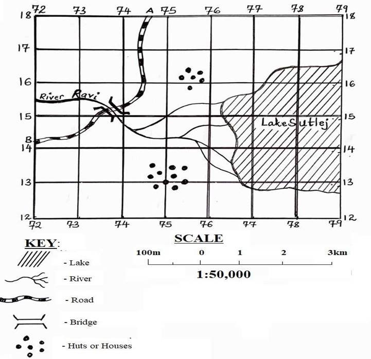
MAP OF MAFIGA:
6. � � � � �(a) � � � �Calculate are covered by Lake Sutlej in kilometer square
_______________________________________________________________
_______________________________________________________________
_______________________________________________________________
_______________________________________________________________
(b)Measure the length of road from point A to point B. (Answer in km)
_______________________________________________________________
_______________________________________________________________
_______________________________________________________________ _______________________________________________________________
_______________________________________________________________
(c)Mention two (2) economic importance of the feature found eastern side of the � � �map:
(i)________________________________________________________
(ii)______________________________________________________________
(d)Identify the feature found at grid reference 750130:
� � � � � � � � � � � � � � The feature is
_______________________________________________________________
_______________________________________________________________
(e)Name two (2) man made features shown on a map.
(i)________________________________________________________
(ii)________________________________________________________
SECTION C: (30 Marks)
Answer two (2) questions in this section
7.The types of human activities are always related to the type of settlement. Elaborate four
(4) importance of human activities.
8.Explain why electricity is preferable source of power than fuel wood (Give five points)
9.Suggest any four (4) ways in which the tourism sector can be used to generate more income in Tanzania.
10.Outline five (5) ways of reducing industrial pollution in the world.
___________________________________________________________________________ _16px;">___________________________________________________________________________
FORM TWO GEOGRAPHY EXAM SERIES 76
FORM TWO GEOGRAPHY EXAM SERIES 76
THE PRESIDENT’S OFFICE
MINISTRY OF EDUCATION, REGIONAL ADMINISTRATION AND LOCAL GOVERNMENT
SECONDARY EXAMINATION SERIES
GEOGRAPHY MID TERM EXAMINATION
FORM TWO-AUG/SEPT-2021
Time: 2:30Hours
Instructions.
- This paper consists of section A, B and C with a total of 10 questions
- Answer all questions in section A and B and TWO questions from section C.
- Section A carries 25 marks, section B 45 marks and section C 30 Marks
- All answers should be written in the spaces provided.
- All communication devices, calculators and any unauthorized material are not allowed in examination room.
- Write your number on every page of your answer booklet.
SECTION A (35 Marks)
Answer All questions in this section.
- For each of the items (i)-(x), choose the correct answer from the alternatives given.
(i)The planet which is known to support life is the:
- sun
- moon
- earth
- mercury
(ii)The grid reference of station X is 261582. What are the numbers of the Eastings and the Northings?
- 583 are Eastings and 261 are Northings
- 158 are Eastings and 262 are Northings
- 582 are Northings and 261 are Eastings
- 651 are Northings and 582 are Eastings
(iii)The structure of the earth is composed of:
- carbon and sodium
- crust, mantle and core
- silicon and alumina
- sima and sial
(iv)Which of the following tropical climates has the largest diurnal temperature range?
- Tropical monsoon
- Hot deserts
- Mediterranean
- Cold deserts
(v)A representative scale of can be represented by a statement scale of:
- 0.5 to 2.5 km
- 2cm to 25 km
- one cm to 2.5 km
- One cm to 250,000 cm
(vi)The time when the sun is overhead on latitude 23½0S or 3½0N is called:
- Solstice
- Aphelion
- Equinox
- Tropic of Cancer
(vii)Wind blows from:
- highlands to lowlands
- lowlands to highlands
- low pressure areas to high pressure areas
- high pressure areas to low pressure areas
(viii) The relative humidity of a region is low when:
- The wet and dry bulb thermometers read the same
- The difference between the readings of wet and dry bulb thermometers is large
- The temperatures are high
- The temperatures are low
(ix) Metallurgical industries deal with:
- machinery
- jewellery
- textile
- food products
(x) Hot deserts are characterized by:
- small range of temperature
- two peaks of annual rainfall
- large range of temperature
- high temperature during the day and night.
2. Match the items in List A with responses in List B by writing the letter of the correct response below the number of corresponding item in the table provided.
| LIST A | LIST B |
|
|
3.Write TRUE if the statement is correct or FALSE if the statement is not correct against each of the following statements.
(i)Agulhas is a good example of a warm current. .......
(ii)Pests and diseases are not common problems facing the farmers in Tanzania. .........
(iii)The Earth rotates from East to West......
(iv)Transportation involves the movement of goods, people and services from one place to another. .........
(v)The energy produced due to the movement of water is biogas. .........
(vi)A key acts as a dictionary of a map. .........
(vii)Salinity ofthe ocean water varies from place to place due to the different rates of evaporation. .........
(viii)Seasons are the result of earth rotation. .........
(ix)All latitudes are great circles. .........
(x)The main crop produced in Gezira irrigation scheme in Sudan is cotton.......
SECTION B (45 Marks)
Answer all questions in this section.
4.(a) Outline five importance of human activities
(b) Mention the characteristics of small scale Agriculture
5. (a) Define the following terms as used in Geography:
(i)Agriculture
(ii)Topographical map
(b) List two conditions necessary for establishing Hydro-Electric Power.
6. Explain the achievements that were brought by the Tennessee Valley Authority in North America.
SECTION C (30 Marks)
Answer two (2) questions from this section.
7. (a) Carefully study the climatic data given for station X and then answer the questions that follow:
| Month | J | F | M | A | M | J | J | A | S | O | N | D |
| Temp °C | 30 | 30 | 30 | 31 | 32 | 38 | 37 | 37 | 35 | 34 | 31 | 30 |
| RAINFALL (mm) | 10 | 20 | 26 | 15 | 8 | 0 | 0 | 0 | 12 | 18 | 15 | 10 |
(i) Calculate the annual range of temperature.
(ii) Determine the annual rainfall.
(iii) Calculate the mean annual temperature.
(iv) What type of climate does station X experience? Give reasons.
(v) Suggest the hemisphere in which station X is located.
(b)Study carefully the map provided below, then answer the questions that follow.
8.Describe five problems facing transportation industry in East Africa
9. Explain five problems that are facing the Rufiji basin project in Tanzania.
10. Explain how forests are endangered in Tanzania and suggest measures that can save them.
|
|
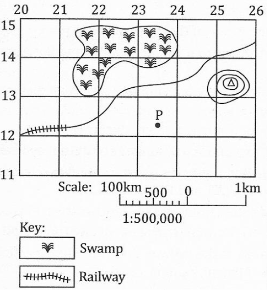
(i)List twoways used by this map to express the scale.
(ii)Give the indicators from the map which shows lowland and highland.
(iii)Why is the railway line not straight from grid reference 260144 to 200144?
(iv)Measure the length of the railway line from grid reference 260144 to 200120.
(v)Calculate the area covered by the swamp. Give your answer in square kilometres.
FORM TWO GEOGRAPHY EXAM SERIES 67
FORM TWO GEOGRAPHY EXAM SERIES 67
MINISTRY OF EDUCATION, REGIONAL ADMINISTRATION AND LOCAL GOVERNMENT
SECONDARY EXAMINATION SERIES
GEOGRAPHYTERMINALEXAMINATION
FORM TWO-2021
Time: 2:30Hours
Instructions.
- This paper consists of section A, B and C with a total of 10 questions
- Answer all questions in section A and B and TWO questions from section C.
- Section A carries 25 marks, section B 45 marks and section C 30 Marks
- All answers should be written in the spaces provided.
- All communication devices, calculators and any unauthorized material are not allowed in examination room.
- Write your number on every page of your answer booklet.
SECTION A (35 Marks)
Answer All questions in this section.
- For each of the items (i)-(x), choose the correct answer from the alternatives given.
(i) The direction to which compass needle points is called
- Magnetic north
- True north
- Grid north
- Compass bearing
(ii) The condition of the atmosphere recorded for a short period of time is known as
- Climate
- Rainfall
- Weather
- Temperature
(iii) The four seasons of the year are the result of
- Rotation of the earth
- Lunar eclipse
- Revolution of the earth
- Solar eclipse.
(iv) The winds which blow from the sea to land is called
- Wind breeze
- See breeze
- Land breeze
- Ocean current
(v)Which type of mountains results from the eruption of molten rocks from the earth interior?
- Volcanic mountains
- Block mountains
- Residual mountains
- Fold mountains
(vi)Which one of the following instrument is not the component of a weather station?
- Rain gauge
- Wind vane
- Microscope
- Stevenson screen
(vii)The height above the sea level is called:
- Altitude
- Contour
- Latitude
- Ocean
(viii)Which one of the following are block mountains?
- Usambara, Sinai and Himalaya.
- Andes, Atlas and Usambara.
- Usambara, Ruwenzori and Sinai.
- , Uluguru and Usambara.
(ix)A scale of a map is said to be enlarged when:
- its denominator is increased
- its denominator and numerator are the same
- its denominator is reduced
- its numerator is increased
(x)The process whereby water vapour is turned into water droplets is called:
- evaporation
- condensation
- saturation
- transpiration
2.Match the items in List A with responses in List B by writing the letter of the correct response below the corresponding item number in the table provided.
| LIST A | LIST |
|
|
3.
- The continent that is crossed by both tropics of Cancer and Capricorn is Africa .:........
- side of mountain that faces the direction of the wind is known as leeward side .......
- Steroids are solid heavenly bodies revolving around the sun mostly between Mars and Jupiter ......
- (iii)An eclipse is described as partial when only a part of heavenly body is obscured .........
- (iv)Maximum thermometer records both maximum temperature with a day........
- (v)Grid reference and bearing are used to determine the position of a place on a map ....
- A dormant volcano is one that still experiences periodical eruptions
- The rotation of the earth results into four seasons of a year .........
- Any circle which divides a globe into hemispheres is known as great circle ..........
- The Stevenson screen is painted white to reflect light from the moon.
SECTION B (45 Marks)
Answer all questions in this section.
4. (a) Giving one example, briefly explain four main categories of mountain.
(i) …………… …………… …………… ……………
(ii) ……………… ……………… ………………
(iii) …………… ……………… ……………… ………………
(iv) ……………… ……………… ……………… ………………
(b) Briefly explain the formation of rift valleys.
……………… …… ………… ………………
5. (a) Outline four features of Linear Scale
(i) …………… …………………… ……………………
(ii) …………………… …………………… ………………
(iii) …………………… …………………… ………………
(iv) …………………… ……………………… ……………
(b) Briefly describe five essentials of a map
(i) ……………… ………………… ………………………
(ii) ……………… ………………………… …………………
(iii) ……… …………… ……………………… …………
(iv) ……… ………………………… ………………… ……
(v) ……………… ………………… ………………… …
6. Study the sketch map provided and answer the questions that follow:

- Name the type of scale which has been used to represent this map.
- Mention three ways which can be used to measure the distance of the road in the sketch map.
- Briefly describe three important basic components of a map.
- Convert the given scale into a statement.
- Mention three methods which can be used to calculate the area of the forest shown on the sketched map.
SECTION C (30 Marks)
Answer two (2) questions from this section.
7.(a) Outline five evidences to verify that the Earth is spherical.
(b) Differentiate the following terms:
![]() (i) Meteors and satellites
(i) Meteors and satellites
(ii) Sea and lake
8.(a) Outline four ways of determining direction of a place on a map.
9. Describe five factors which enhance a conducive environment for generation of energy.
10.Describe five negative effects of crop cultivation to the environment.
(b) List four features of the Representative Fraction (RF) scale.
(c) Suggest two ways of measuring areas with irregular shapes.
FORM TWO GEOGRAPHY EXAM SERIES 60
FORM TWO GEOGRAPHY EXAM SERIES 60
Student’s Examination No._____________________________
THE PRESIDENT’S OFFICE
MINISTRY OF EDUCATION, REGIONAL ADMINISTRATION AND LOCAL GOVERNMENT
SECONDARY EXAMINATION SERIES
GEOGRAPHY MID TERM EXAMINATION-MARCH
FORM TWO-2021
Time: 2:30Hours
Instructions.
- This paper consists of section A, B and C with a total of 10 questions
- Answer all questions in section A and B and TWO questions from section C.
- Section A carries 25 marks, section B 45 marks and section C 30 Marks
- All answers should be written in the spaces provided.
- All communication devices, calculators and any unauthorized material are not allowed in examination room.
- Write your number on every page of your answer booklet.
SECTION A (35 Marks)
Answer All questions in this section.
For each of the items (i)-(x), choose the correct answer from the alternatives given.
- The Grid reference of station X is 612825. What are the numbers of Eastings and the Northings?
- 825 are Northings and 612 are Eastings
- 612 are Northings and 825 are Eastings
- 282 are Northings and 612 are Eastings
- 825 are Northings and 216 are Eastings
(ii) People living in Tanga see the sun earlier than in Kigoma. What does this fact indicate?
- People in Kigoma sleep longer
- The earth rotates from East to West
- The earth rotates from West to East
- There are many hills and mountains in Kigoma
(iii) If it is 3.00 p.m. at Bukoba 33oE in Tanzania. What will be the time at Tehran 50oE in Iran?
- 10:00 a.m.
- 4:08 p.m.
- 4:32 p.m.
- 10:00 p.m.
(iv) Morogoro at 800m above sea level has a temperature reading of 28oC. Determine the temperature of Karatu which is located at 1400 metres above sea level.
- 31.6oC.
- 3.6oC.
- 24oC.
- 24.4oC.
(v) The side of a mountain facing the direction of the wind is known as
- Leeward side.
- Fore side.
- Backward side.
- Windward side.
(vi) A ship moves to the West and crosses the International Date Line. What happens with regard to time gained or lost?
- No time is gained or lost.
- One whole day is lost.
- One whole day is gained.
- One whole day is repeated.
(vii) The four seasons which occur on the earth’s surface are the result of
- Rotation of the earth.
- Ferel’s law.
- The tilting of the earth on its own axis.
- Revolution of the earth.
(viii) Which of the following is the smallest scale?
- 1: 100,000
- 1: 10,000
- 1: 25,000
- 1: 50,000
(ix) Which of the following give the proof that the earth is spherical in shape?
- Circumnavigation of the earth, solar eclipse and lunar eclipse.
- Ship’s visibility, lunar eclipse and aerial photograph.
- Great circles, longitudes and small circles.
- Lunar eclipse, the planets and the earth’s orbit.
(x) What is the compass bearing of North North West (NNW)?
- 337½o B. 292½o C. 202½o D. 67½o
| i | ii | iii | iv | v | vi | vii | viii | ix | X |
2. Match the item in column A with the corresponding items in column B by writing the letter of the correct item in column B against its corresponding number in column A.
| COLUMN A | COLUMN B |
|
|
| COLUMN A | i | ii | iii | iv | V |
| COLUMN B |
3. Write “TRUE” against a correct statement or “FALSE” against an incorrect statement.
- Lines drawn on a map joining points with the same pressure are called Isotherm
- There is large land surface in the northern hemisphere than in the southern hemisphere
- The growing of fruits, vegetables and flowers is known as horticulture.
- Pests, diseases, price fluctuation and markets are serious problem in monoculture farming
- Wind blow from areas of low pressure to areas of high pressure.
- TAZAMA is the railway line running from Dar es Salaam, Tanzania to Kapiri Mposhi, Zambia.
- The only continent crossed by both tropics of Cancer and Capricorn is Europe
- Maximum thermometer filled with alcohol is used to determine the highest temperature reached in a day
- Afforestation process decrease global warming
- The wise use and control of water resources is known as water supply
| I | ii | iii | iv | v | vi | vii | viii | Ix | X |
SECTION B: (45 MARKS)
Answer all questions in this section
4. a) Briefly explain the following geographical terms
- Transhumance
__________________________________________________________________________________________________________________________________________________________________________________________________________________________________________
- Sedentary farming
__________________________________________________________________________________________________________________________________________________________________________________________________________________________________________
- Six’s thermometer
__________________________________________________________________________________________________________________________________________________________________________________________________________________________________________
- Atmospheric pressure
__________________________________________________________________________________________________________________________________________________________________________________________________________________________________________
- Bush fallowing
__________________________________________________________________________________________________________________________________________________________________________________________________________________________________________
b) Mention five merits of bush fallowing
- _______________________________________________________________________
- _______________________________________________________________________
- _______________________________________________________________________
- _______________________________________________________________________
- _______________________________________________________________________
c) With the aid of well diagram explain the formation of solstice
| Diagram | Explanation |
- List down five factors which make navigation difficult in most African rivers.
- __________________________________________________________________
- __________________________________________________________________
- __________________________________________________________________
- __________________________________________________________________
- __________________________________________________________________
e) Highlight five benefits of Tennessee Valley Authority (TVA)
- ________________________________________________________________________
- _______________________________________________________________________
- _______________________________________________________________________
- _______________________________________________________________________
- ________________________________________________________________________
f) Carefully study the climatic data given for station Q and answer the questions that follow:
| Month | J | F | M | A | M | J | J | A | S | O | N | D |
| Temp. in 0C | 13.3 | 16.1 | 20.0 | 25.0 | 28.9 | 35.0 | 36.7 | 35.8 | 32.8 | 26.7 | 19.1 | 14.4 |
| Rainfall in mm | 2.5 | 2.5 | 0 | 0 | 0 | 0 | 0 | 2.5 | 0 | 0 | 2.5 | 15.0 |
- Calculate the mean annual temperature.
- Calculate the total annual rainfall for the station.
- Give the annual range of temperature for the station.
- Suggest the type of climate for the station
5. a) If the map distance of Ruvu river is 29 centimeters, calculate the actual distance of Ruvu River in kilometers given that the map scale is 1:25,000.
- In station P on a map, an area covered by thick forest was found to be 12 full squares and 26 half squares. Calculate the area of the thick forest in square kilometers, given scale: 1:50,000 ____________________________________________________________________________________________________________________________________________________________________________________________________________________________________________________________________________________________________________________________________________________________________________________________________________________________________________________________________________________________________________________________________________________________________________________________________________________________________________________________________________________________________________________________________________________________________________________________________________________________________________________________________________________________________________________________________________________________________________________________________________________________________________________________________________________________________________________________________________________________________________________________________________________________________________________________________________________________________________________________________________________________________________________________________________________________________________________________
- Mention five uses of scale in the map
- __________________________________________________________________________
- ___________________________________________________________________________
- ___________________________________________________________________________
- ___________________________________________________________________________
- ___________________________________________________________________________
- List down five ways of locating features in the map
- _______________________________________________________________________________
- _______________________________________________________________________________
- _______________________________________________________________________________
- _______________________________________________________________________________
- ________________________________________________________________________________
SECTION C: (30 MARKS)
Answer only TWO questions in this section
6. Agriculture in Tanzania is affected with land conflicts. Describe six causes of land conflicts in our country.
7. Analyze six problems facing coffee production in East Africa
8. Explain seven advantages of growing cash crops in Tanzania
9. Discuss six factors affecting water supply in the Sub-Saharan countries
10. Describe the problems uncounted the development of Rufiji Basin Development Authority (RUBADA)
_____________________________________________________________________________________________________________________________________________________________________________________________________________________________________________________________________________________________________________________________________________________________________________________________________________________________________________________________________________________________________________________________________________________________________________________________________________________________________________________________________________________________________________________________________________________________________________________________________________________________________________________________________________________________________________________________________________________________________________________________________________________________________________________________________________________________________________________________________________________________________________________________________________________________________________________________________________________________________________________________________________________________________________________________________________________________________________________________________________________________________________________________________________________________________________________________________________________________________________________________________________________________________________________________________________________________________________________________________________________________________________________________________________________________________________________________________________________________________________________________________________________________________________________________________________________________________________________________________________________________________________________________________________________________________________________________________________________________________________________________________________________________________________________________________________________________________________________________________________________________________________________________________________________________________________________________________________________________________________________________________________________________________________________________________________________________________________________________________________________________________________________________________________________________________________________________________________________________________________________________________________________________________________________________________________________________________________________________________________________________________________________________________________________________________________________________________________________________________________________________________________________________________________________________________________________________________________________________________________________________________________________________________________________________________________________________________________________________________________________________________________________________________________________________________________________________________________________________________________________________________________________________________________________________________________________________________________________________________________________________________________________________________________________________________________________________________________________________________________________________________________________________________________________________________________________________________________________________________________________________________________________________________________________________________________________________________________________________________________________________________________________________________________________________________________________________________________________________________________________________________________________________________________________________________________________________________________________________________________________________________________________________________________________________________________________________________________________________________________________________________________________________________________________________________________________________________________________________________________________________________________________________________________________________________________________________________________________________________________________________________________________________________________________________________________________________________________________________________________________________________________________________________________________________________________________________________________________________________________________________________________________________________________________________________________________________________________________________________________________________________________________________________________________________________________________________________________________________________________________________________________________________________________________________________________________________________________________________________________________________________________________________________________________________________________________________________________________________________________________________________________________________________________________________________________________________________________________________________________________________________________________________________________________________________________
__________________________________________________________________________________________________________________________________________________________________________________________________________________________________________________________________________________________________________________________________________________________________________________________________________________________________________________________________________________________________________________________________________________________________________________________________________________________________________________________________________________________________________________________________________________________________________________________________________________________________________________________________________________________________________________________________________________________________________________________________________________________________________________________________________________________________________________________________________________________________________________________________________________________________________________________________________________________________________________________________________________________________________________________________________________________________________________________________________________________________________________________________________________________________________________________________________________________________________________________________________________________________________________________________________________________________________________________________________________________________________________________________________________________________________________________________________________________________________________________________________________________________________________________________________________________________________________________________________________________________________________________________________________________________________________________________________________________________________________________________________________________________________________________________________________________________________________________________________________________________________________
1
FORM TWO GEOGRAPHY EXAM SERIES 55
FORM TWO GEOGRAPHY EXAM SERIES 55
Student’s Examination No._____________________________
THE PRESIDENT’S OFFICE
MINISTRY OF EDUCATION, REGIONAL ADMINISTRATION AND LOCAL GOVERNMENT
SECONDARY EXAMINATION SERIES
GEOGRAPHY MID TERM EXAMINATION
FORM TWO-2021
Time: 2:30Hours
Instructions.
- This paper consists of section A, B and C with a total of 10 questions
- Answer all questions in section A and B and TWO questions from section C.
- Section A carries 25 marks, section B 45 marks and section C 30 Marks
- All answers should be written in the spaces provided.
- All communication devices, calculators and any unauthorized material are not allowed in examination room.
- Write your number on every page of your answer booklet.
SECTION A (25 Marks)
Answer All questions in this section.
For each of the items (i)-(x), choose the correct answer from the alternatives given.
- The Grid reference of station X is 612825. What are the numbers of Eastings and the Northings?
- 825 are Northings and 612 are Eastings
- 612 are Northings and 825 are Eastings
- 282 are Northings and 612 are Eastings
- 825 are Northings and 216 are Eastings
(ii) People living in Tanga see the sun earlier than in Kigoma. What does this fact indicate?
- People in Kigoma sleep longer
- The earth rotates from East to West
- The earth rotates from West to East
- There are many hills and mountains in Kigoma
(iii) If it is 3.00 p.m. at Bukoba 33oE in Tanzania. What will be the time at Tehran 50oE in Iran?
- 10:00 a.m.
- 4:08 p.m.
- 4:32 p.m.
- 10:00 p.m.
(iv) Morogoro at 800m above sea level has a temperature reading of 28oC. Determine the temperature of Karatu which is located at 1400 metres above sea level.
- 31.6oC.
- 3.6oC.
- 24oC.
- 24.4oC.
(v) The side of a mountain facing the direction of the wind is known as
- Leeward side.
- Fore side.
- Backward side.
- Windward side.
(vi) A ship moves to the West and crosses the International Date Line. What happens with regard to time gained or lost?
- No time is gained or lost.
- One whole day is lost.
- One whole day is gained.
- One whole day is repeated.
(vii) The four seasons which occur on the earth’s surface are the result of
- Rotation of the earth.
- Ferel’s law.
- The tilting of the earth on its own axis.
- Revolution of the earth.
(viii) Which of the following is the smallest scale?
- 1: 100,000
- 1: 10,000
- 1: 25,000
- 1: 50,000
(ix) Which of the following give the proof that the earth is spherical in shape?
- Circumnavigation of the earth, solar eclipse and lunar eclipse.
- Ship’s visibility, lunar eclipse and aerial photograph.
- Great circles, longitudes and small circles.
- Lunar eclipse, the planets and the earth’s orbit.
(x) What is the compass bearing of North North West (NNW)?
- 337½o B. 292½o C. 202½o D. 67½o
| i | ii | iii | iv | v | vi | vii | viii | ix | X |
2. Match the item in column A with the corresponding items in column B by writing the letter of the correct item in column B against its corresponding number in column A.
| COLUMN A | COLUMN B |
|
|
| COLUMN A | i | ii | iii | iv | V |
| COLUMN B |
3. Write “TRUE” against a correct statement or “FALSE” against an incorrect statement.
- Lines drawn on a map joining points with the same pressure are called Isotherm
- There is large land surface in the northern hemisphere than in the southern hemisphere
- The growing of fruits, vegetables and flowers is known as horticulture.
- Pests, diseases, price fluctuation and markets are serious problem in monoculture farming
- Wind blow from areas of low pressure to areas of high pressure.
- TAZAMA is the railway line running from Dar es Salaam, Tanzania to Kapiri Mposhi, Zambia.
- The only continent crossed by both tropics of Cancer and Capricorn is Europe
- Maximum thermometer filled with alcohol is used to determine the highest temperature reached in a day
- Afforestation process decrease global warming
- The wise use and control of water resources is known as water supply
| I | ii | iii | iv | v | vi | vii | viii | Ix | X |
SECTION B: (45 MARKS)
Answer all questions in this section
4. a) Briefly explain the following geographical terms
- Transhumance
__________________________________________________________________________________________________________________________________________________________________________________________________________________________________________
- Sedentary farming
__________________________________________________________________________________________________________________________________________________________________________________________________________________________________________
- Six’s thermometer
__________________________________________________________________________________________________________________________________________________________________________________________________________________________________________
- Atmospheric pressure
__________________________________________________________________________________________________________________________________________________________________________________________________________________________________________
- Bush fallowing
__________________________________________________________________________________________________________________________________________________________________________________________________________________________________________
b) Mention five merits of bush fallowing
- _______________________________________________________________________
- _______________________________________________________________________
- _______________________________________________________________________
- _______________________________________________________________________
- _______________________________________________________________________
c) With the aid of well diagram explain the formation of solstice
| Diagram | Explanation |
- List down five factors which make navigation difficult in most African rivers.
- __________________________________________________________________
- __________________________________________________________________
- __________________________________________________________________
- __________________________________________________________________
- __________________________________________________________________
e) Highlight five benefits of Tennessee Valley Authority (TVA)
- ________________________________________________________________________
- _______________________________________________________________________
- _______________________________________________________________________
- _______________________________________________________________________
- ________________________________________________________________________
f) Carefully study the climatic data given for station Q and answer the questions that follow:
| Month | J | F | M | A | M | J | J | A | S | O | N | D |
| Temp. in 0C | 13.3 | 16.1 | 20.0 | 25.0 | 28.9 | 35.0 | 36.7 | 35.8 | 32.8 | 26.7 | 19.1 | 14.4 |
| Rainfall in mm | 2.5 | 2.5 | 0 | 0 | 0 | 0 | 0 | 2.5 | 0 | 0 | 2.5 | 15.0 |
- Calculate the mean annual temperature.
- Calculate the total annual rainfall for the station.
- Give the annual range of temperature for the station.
- Suggest the type of climate for the station
5. a) If the map distance of Ruvu river is 29 centimeters, calculate the actual distance of Ruvu River in kilometers given that the map scale is 1:25,000.
- In station P on a map, an area covered by thick forest was found to be 12 full squares and 26 half squares. Calculate the area of the thick forest in square kilometers, given scale: 1:50,000 ____________________________________________________________________________________________________________________________________________________________________________________________________________________________________________________________________________________________________________________________________________________________________________________________________________________________________________________________________________________________________________________________________________________________________________________________________________________________________________________________________________________________________________________________________________________________________________________________________________________________________________________________________________________________________________________________________________________________________________________________________________________________________________________________________________________________________________________________________________________________________________________________________________________________________________________________________________________________________________________________________________________________________________________________________________________________________________________________
- Mention five uses of scale in the map
- __________________________________________________________________________
- ___________________________________________________________________________
- ___________________________________________________________________________
- ___________________________________________________________________________
- ___________________________________________________________________________
- List down five ways of locating features in the map
- _______________________________________________________________________________
- _______________________________________________________________________________
- _______________________________________________________________________________
- _______________________________________________________________________________
- ________________________________________________________________________________
6. Agriculture in Tanzania is affected with land conflicts. Describe six causes of land conflicts in our country.
SECTION C: (30 MARKS)
Answer only TWO questions in this section
7. Analyze six problems facing coffee production in East Africa
8. Explain seven advantages of growing cash crops in Tanzania
9. Discuss six factors affecting water supply in the Sub-Saharan countries
10. Describe the problems uncounted the development of Rufiji Basin Development Authority (RUBADA)
_____________________________________________________________________________________________________________________________________________________________________________________________________________________________________________________________________________________________________________________________________________________________________________________________________________________________________________________________________________________________________________________________________________________________________________________________________________________________________________________________________________________________________________________________________________________________________________________________________________________________________________________________________________________________________________________________________________________________________________________________________________________________________________________________________________________________________________________________________________________________________________________________________________________________________________________________________________________________________________________________________________________________________________________________________________________________________________________________________________________________________________________________________________________________________________________________________________________________________________________________________________________________________________________________________________________________________________________________________________________________________________________________________________________________________________________________________________________________________________________________________________________________________________________________________________________________________________________________________________________________________________________________________________________________________________________________________________________________________________________________________________________________________________________________________________________________________________________________________________________________________________________________________________________________________________________________________________________________________________________________________________________________________________________________________________________________________________________________________________________________________________________________________________________________________________________________________________________________________________________________________________________________________________________________________________________________________________________________________________________________________________________________________________________________________________________________________________________________________________________________________________________________________________________________________________________________________________________________________________________________________________________________________________________________________________________________________________________________________________________________________________________________________________________________________________________________________________________________________________________________________________________________________________________________________________________________________________________________________________________________________________________________________________________________________________________________________________________________________________________________________________________________________________________________________________________________________________________________________________________________________________________________________________________________________________________________________________________________________________________________________________________________________________________________________________________________________________________________________________________________________________________________________________________________________________________________________________________________________________________________________________________________________________________________________________________________________________________________________________________________________________________________________________________________________________________________________________________________________________________________________________________________________________________________________________________________________________________________________________________________________________________________________________________________________________________________________________________________________________________________________________________________________________________________________________________________________________________________________________________________________________________________________________________________________________________________________________________________________________________________________________________________________________________________________________________________________________________________________________________________________________________________________________________________________________________________________________________________________________________________________________________________________________________________________________________________________________________________________________________________________________________________________________________________________________________________________________________________________________________________________________________________________________________________________________
__________________________________________________________________________________________________________________________________________________________________________________________________________________________________________________________________________________________________________________________________________________________________________________________________________________________________________________________________________________________________________________________________________________________________________________________________________________________________________________________________________________________________________________________________________________________________________________________________________________________________________________________________________________________________________________________________________________________________________________________________________________________________________________________________________________________________________________________________________________________________________________________________________________________________________________________________________________________________________________________________________________________________________________________________________________________________________________________________________________________________________________________________________________________________________________________________________________________________________________________________________________________________________________________________________________________________________________________________________________________________________________________________________________________________________________________________________________________________________________________________________________________________________________________________________________________________________________________________________________________________________________________________________________________________________________________________________________________________________________________________________________________________________________________________________________________________________________________________________________________________________________
1
FORM TWO GEOGRAPHY EXAM SERIES 50
FORM TWO GEOGRAPHY EXAM SERIES 50
Student’s Examination No........................................................
THE PRESIDENT’S OFFICE
MINISTRY OF EDUCATION, REGIONAL ADMINISTRATION AND LOCAL GOVERNMENT
SECONDARY EXAMINATION SERIES
GEOGRAPHY MID TERM EXAMINATION-MARCH
FORM ONE-2021
Time: 2:30Hours
Instructions.
- This paper consists of section A, B and C with a total of 10 questions
- Answer all questions in section A and B and TWO questions from section C.
- Section A carries 25 marks, section B 45 marks and section C 30 Marks
- All answers should be written in the spaces provided.
- All communication devices, calculators and any unauthorized material are not allowed in examination room.
- Write your number on every page of your answer booklet.
SECTION A (35 Marks)
Answer All questions in this section.
- For each of the items (i)-(x), choose the correct answer from the alternatives given.
- Write down the letter of the most correct answer for each of the following questions;
- The large ball burning in the space is;
- Star b) milk way c) universe d) moon
- The four season which occurs on the earth’s surface are the result of;
- Circumnavigation of the earth c) Earth’s axis
- Rotation d) revolution
- The body of solar system is;
- The planet b) the sun c) the moon d) the Earth
- The spinning of the earth on its own axis known as;
- Revolution c) day and night
- Rotation of the Earth d) Solar system
- What will happen when ships moves to the West and cross the International date line (IDL);
- No day is gain or lost c) one whole day is gain
- One whole day is lost d) one whole day is repeated
- Which of the following is not aspect of Geography;
- Human right education c) Different land forms
- Map reading d) practical geography
- If it is 12.00pm in Kenya 45?E, what will be the time of Central Africa republic 30?E
- 11:00pm b) 06:00pm c) 11:00am d) 12:00pm
- The satellite of the Earth is;
- Asteroids b) comet c) moon d) sun
- The smallest planet in the solar system is;
- Jupiter b) Saturn c) Uranus d) Earth
- Which is the source of solar energy:
- Solar power b) the sun c) stars d) solar panel
ANSWERS
| i | ii | iii | iv | v | vi | vii | viii | ix | x |
- Match the terms in list A that responding with the response of list B and write its answer in the box provided below: (10 marks)
| LIST A | LIST B |
|
|
ANSWERS
| List A | i | ii | iii | iv | v | vi | vii | viii | ix | x |
| List B |
- The following statements are either correct or incorrect. Write “T” for correct F for incorrect (10 marks)
- The deepest lake in Africa is lake Tanganyika
- Human activities geography deals with soil, landforms and water bodies
- In leap year February has 28 days instead of 29 days
- Prime meridian is also called Greenwich Meridian
- Lunar eclipse occurs during the right
- All longitude and Latitude run from North to South
- There are four seasons of the year
- The Earth rotates from West to East
- Solar energy does not promote environment conservation
- Great circles divides the Earth equally
ANSWERS
| i | ii | iii | iv | v | vi | vii | viii | ix | x |
SECTION B (45 Marks)
Answer all questions in this section.
- Define the following terms (10 marks)
- Pangea
................................................................................................................................................................................................................................................................................................................................................................................................................................................................
- Longitude
................................................................................................................................................................................................................................................................................................................................................................................................................................................................
- Great circle
..............................................................................................................................................................................................................................................................................................................................................................................................................................................................
- Seasons
................................................................................................................................................................................................................................................................................................................................................................................................................................................................
- Geroid
................................................................................................................................................................................................................................................................................................................................................................................................................................................................
- Differentiate between the following geographical items; (10 marks)
- Umbra and Penumbra
................................................................................................................................................................................................................................................................................................................................................................................................................................................................................................................................................................................
- Apogee and Perigee
................................................................................................................................................................................................................................................................................................................................................................................................................................................................................................................................................................................
- Solar system and solar energy
................................................................................................................................................................................................................................................................................................................................................................................................................................................................................................................................................................................
- Rotation and revolution
................................................................................................................................................................................................................................................................................................................................................................................................................................................................................................................................................................................
- Aphelion and Perihelion
................................................................................................................................................................................................................................................................................................................................................................................................................................................................................................................................................................................
- (a) Mention and draw the arrangement of all planets (05 marks)
(b) With the help of diagram explain the occurrence of the Lunar eclipse. (05 marks)
SECTION C ( Marks)
Answer two Questions from this section
- Mention five evidence which prove the Earths is spherical shape (05 marks)
- ................................................................................................................................................................................................................................
- ................................................................................................................................................................................................................................
- ................................................................................................................................................................................................................................
- ................................................................................................................................................................................................................................
- ................................................................................................................................................................................................................................
- Explain how solar energy emancipation women
- Explain five points uses of solar energy
- Explain five points on how solar energy used as alternative way of conserving environment
........................................................................................................................................................................................................................................................................................................................................................................................................................................................................................................................................................................................................................................................................................
........................................................................................................................................................................................................................................................................................................................................................................................................................................................................................................................................................................................................................................................................................
........................................................................................................................................................................................................................................................................................................................................................................................................................................................................................................................................................................................................................................................................................
........................................................................................................................................................................................................................................................................................................................................................................................................................................................................................................................................................................................................................................................................................
........................................................................................................................................................................................................................................................................................................................................................................................................................................................................................................................................................................................................................................................................................
........................................................................................................................................................................................................................................................................................................................................................................................................................................................................................................................................................................................................................................................................................
........................................................................................................................................................................................................................................................................................................................................................................................................................................................................................................................................................................................................................................................................................
...............................................................................................................................................................................................................................................................................................................................................................................................................
........................................................................................................................................................................................................................................................................................................................................................................................................................................................................................................................................................................................................................................................................................
.....................................................................................................................................
1 | Page
FORM TWO GEOGRAPHY EXAM SERIES 49
FORM TWO GEOGRAPHY EXAM SERIES 49
THE PRESIDENT’S OFFICE
MINISTRY OF EDUCATION, REGIONAL ADMINISTRATION AND LOCAL GOVERNMENT
SECONDARY EXAMINATION SERIES
GEOGRAPHY MID TERM EXAMINATION
FORM TWO-2021
Time: 2:30Hours
Instructions.
- This paper consists of section A, B and C with a total of 10 questions
- Answer all questions in section A and B and TWO questions from section C.
- Section A carries 25 marks, section B 45 marks and section C 30 Marks
- All answers should be written in the spaces provided.
- All communication devices, calculators and any unauthorized material are not allowed in examination room.
- Write your number on every page of your answer booklet.
SECTION A (35 Marks)
Answer All questions in this section.
- For each of the items (i)-(x), choose the correct answer from the alternatives given.
(i). The most common and perhaps the most important of socio – economic activities include:-
- Pastoralism, cultivation and trading activities
- Agriculture, trade and cultural activities.
- Arts, crafts and ceramics
- Recreation, initiation and traditional healing
(ii). The coastal zone people are involved in which type of human activities?
- Fishing, trading and small scale agriculture
- Lumbering, trading and hand crafts
- Initiation, recreation and social activities.
- Lumbering, mining and small scale agriculture.
(iii). Cultural practice in economic activities includes the following activities.
- Initiation, arts and ceramics
- Agriculture, fishing and lumbering.
- Crafts, folklore and trading.
- Lumbering, initiation and ceramics
(iv). The main economic activity for Makonde people is:-
- Carving
- Agricultural activities.
- Lumbering
- Fishing
(v) Harvesting minerals such as copper from underground is called?
- Lumbering
- Quarrying
- Mining
- Extraction
(vi) Acts, functions or occupations executed lawfully by human beings for some purpose is called?
- Production.
- Human activities
- Human occupation
- Economic activity.
(vii) The backbone of Tanzania’s economy is?
- Agriculture
- Mining
- Fishing.
- Livestock keeping.
(viii) Which is not and advanced technique in fishing?
- Drifting
- Trawling
- Seining
- Barrier trap.
(ix). Striping method is used in finding area for
- Irregular shapes
- Regular shapes
- Both regular and irregular shapes
- Plantation farms.
(x). The term Map refers to:-
- Ratio between the distance on the map and the actual distance on the ground.
- Lines connecting all points of equal height above sea level
- A representation of the earth or part of the earth on a flat surface such as paper or chalk board.
- A direction of one point from another expressed in degree of an angle from north clock wise.
2. Match the items from list A with those in list B.
| LIST A | LIST B |
|
|
Write TRUE if the statement is correct and FALSE if the statement is incorrect.
a) When we say it is not, wet or cloudy we are referring to the weather
b) The temperature is measure by hydrometer
c) The three types of rainfall are convectional rainfall, relief rainfall and orographic rainfall
d) Precipitation is the deposition of moisture from the atmosphere on the earth’s surface
e) Relative humidity is the actual amount of water vapour present in a certain volume of air at a given temperature.
f) Altitude is one of the factors which cause rainfall variations
g) Clouds is air in motion from a high pressure area to a low pressure area.
h) Isotherms are lines drawn on a map to join or connect places with the same amount of rainfall
i) An aneroid barometer consists of a small metal box which contains very little air
j) Cirrus, Cirrocumulus and Cirrostratus are referred to as the high clouds which are found at 6,000 to 12,000 meters above sea level.
SECTION B (45 MARKS)
ANSWER ALL QUESTIONS IN THIS SECTION
4. Study the data below than answer the questions that follow.
STATION X.
| Months | J | F | M | A | M | J | J | A | S | O | N | D |
| Temp. | 25.5 | 25.5 | 26.1 | 26.7 | 27.2 | 26.7 | 26.7 | 26.1 | 26.7 | 26.7 | 26.1 | 25.6 |
| Rainfall (mm) | 246 | 180 | 185 | 198 | 65 | 178 | 170 | 198 | 175 | 201 | 256.5 | 264 |
a) Give the annual range of temperature for station X.
b) Calculate the mean temperature for station X.
c) Calculate the annual rainfall for station X.
d) Suggest the type of climate for station X.
e) Give two reasons for suggesting the type of climate for station X.
f) Mention any five types of vegetation found in station X.
g) What are the three major economic activities that can be carried out in station X?
5. Answer the following questions per the given instructions.
a) Mention three types of scales
(i) ………………………………………………………………..
(ii) ………………………………………………………………..
(iii) …………………………………………………………………
b) Name three types of maps
(i) ………………………………………………………………….
(ii) ………………………………………………………………….
(iii) ………………………………………………………………….
c) Identify three methods used to measure areas of irregular shapes in maps
(i) …………………………………………………………………….
(ii) …………………………………………………………………….
(iii) …………………………………………………………………….
d) List five essential of a good map
(i) …………………………………………………………………………………
(ii) …………………………………………………………………………………
(iii) …………………………………………………………………………………
(iv) …………………………………………………………………………………
(v) …………………………………………………………………………………
6. Give the meaning of the following geographical terms:-
a) Geography
b) Physical geography
c) Regional geography
d) Practical geography
SECTION C (30 Marks)
Answer two questions from this section.
7. (a) Briefly explain the meaning of tertiary activity
(b). With specific examples differentiate between the following terms.
i) Primary and secondary activities
ii) Tertiary and primary activities.
iii) Secondary and tertiary activities
8. (a) What is plantation agriculture?
(b) Outline advantages and disadvantages of plantation agriculture.
9. (a) What is Agriculture?
(b) Briefly explain factors that influence agriculture
10. Discuss five importance of human activities.
FORM TWO GEOGRAPHY EXAM SERIES 44
FORM TWO GEOGRAPHY EXAM SERIES 44
THE PRESIDENT'S OFFICE
MINISTRY OF REGIONAL GOVERNMENT AND LOCAL GOVERNMENT
AUGUST-SEPTEMBER EXAMINATION SERIES
GEOGRAPHY FORM-2
2020
TIME: 2:30 HRS
INSTRUCTIONS.
- This paper consists of sections A, B and C with a total of ten (10) questions.
- Answer all questions in section A and B and two (2) questions from section C
- All writing must be in blue or black ink.
- All answers must be written in the space provided.
- Calculators, cellular phones and any unauthorized materials are not allowed in the examination room.
- Write your Examination Number at the top right corner of every page.
SECTION A (25 Marks)
Answer all questions in this section.
1. For each of the items (i) – (ii), choose the correct answer from among the given alternatives and write its letter in the box provided.
(i) One characteristics of equatorial climate is:-
- Low rainfall
- Moderate temperature
- Low humidity
- Thick forest.
(ii) The direction to which compass needle points is called
- Magnetic north
- True north
- Grid north
- Compass bearing
(iii) Cultivation of cash crops based on application of advanced technology is called?
- Subsistence agriculture
- A large scale agriculture
- Mixed system agriculture
- A small scale agriculture
(iv) The condition of the atmosphere recorded for a short period of time is known as
- Climate
- Rainfall
- Weather
- Temperature
(v)Which type of climate among the following is different from the other?
- Mediterranean
- Savanna
- Hot desert
- Equatorial
(vi)Which scale is the largest among the following?
- 1:25,000
- 1:1,500,000
- 1:50,000
- 1: 10,000
(vii)Which one of the following features are correct set of the ocean floor?
- Ridge, basin, plateau and waterfall.
- Continental shelf, basin and waterfall.
- Trench, continental shelf and continental slope.
- Horst, plain and volcano.
(viii)A ship moves to the west and crosses the International Date Line. What happens in regard to time gained or lost?
- No time is gained or lost
- One whole days is lost
- One whole day is gained
- One whole day is repeated
(ix) Hot deserts are characterised by:
- small range of temperature
- two peaks of annual rainfall
- large range of temperature
- high temperature during the day and night.
(x) The land of East Africa is mainly characterized by:
- low lands valley
- highlands plateau and lowlands basin
- volcanic mountains and residue mountains
- highlands and fold mountains.
2.Match the items in List A with responses in List B by writing the letter of the correct response below the corresponding item number in the table provided.
| LIST A | LIST B |
|
|
3. Write True if the statement is correct or False if the statement is not correct in the space provided.
(i)Trans - Saharan Trade involved the exchange of goods between people of Northern and Eastern Africa ......
(ii)The development of Long Distance Trade in East Africa had a direct connection with the rise of Triangular Trade . ......
(iii)The Christian missionaries were against the abolition of slave trade.......
(iv)Industrial capitalism was characterized by open competition for markets and raw materials ...............
(v)The East African coast was known to Greeks and Romans as Azania ......
(vi) The most obvious result of the Mfecane was the depopulation of larger parts of southern Africa.....
(vii)Man learnt to keep animals during Early Stone Age . .......
(viii)The coming of Ngoni in East Africa led to shift from the small scale Ntemi system to weaker states ...............
(ix)The discovery of diamond turned South Africa from poor agricultural society to relatively rich industrial one ...............
(x)Written records refer to the study of our past as revealed by what has been handed down by word of mouth from one generation to another.
SECTION B (45 Marks)
Answer all questions in this section.
4.(a) Mention five features of the ocean floor.
(b) Name the five largest oceans in the world.
(c) Mention five largest lakes in the world.
(d) Differentiate the following terms:
(i)Temperature and humidity
(ii)Minimum and maximum thermometer
(iii) Pressure and wind
5. (a) Distinguish the following terms:
- Solar system and solar energy
- Raw materials and manufacturing industries
- Map and scale of a map
- Plateau and mountain
(b)
- Define lunar eclipse.
- Draw a well labelled diagram to show lunar eclipse.
6. Explain five measures which can be taken to ensure the sustainability of forests in Tanzania.
SECTION C (30 Marks)
Answer two (2) questions from this section.
7. Study the following climatic table and answer the questions that follow.
Station Y
| Months | Jan | Feb | March | Apr | May | June | July | Aug | Sep | Oct | Nov | Dec |
| Temp(0 C) | 22.5 | 25 | 25 | 25.5 | 25.5 | 25.5 | 25.5 | 25.5 | 26.1 | 26.1 | 26.1 | 26.6 |
| Rainfall(mm) | 198 | 340 | 431 | 350 | 280 | 230 | 160 | 71 | 15 | 12 | 15 | 66 |
- Suggest the type of climate of station Y.
- Calculate the daily mean temperature.
- Find the mean annual temperature.
- Find the annual rainfall for station Y.
- Mention any four crops that can be grown in station Y.
8. Describe five advantages of natural gas production in Tanzania
9. Describe six characteristics of small scale agriculture.
10.Using examples, explain five problems facing livestock farming in Africa.
FORM TWO GEOGRAPHY EXAM SERIES 33
FORM TWO GEOGRAPHY EXAM SERIES 33
THE PRESIDENT’S OFFICE MINISTRY OF EDUCATION, LOCAL ADMINISTRATION AND LOCAL GOVERNMENT
GEOGRAPHY- BACK TO SCHOOL EXAMINATION-JUNE
FORM TWO
Time 2:30 Hours JUNE 2020
INSTRUCTIONS.
- This paper consists of sections A, B and C with a total of ten (10) questions.
- Answer all questions in section A and B and two (2) questions from section C
- All writing must be in blue or black ink.
- All answers must be written in the space provided.
- Calculators, cellular phones and any unauthorized materials are not allowed in the examination room.
- Write your Examination Number at the top right corner of every page.
SECTION A (25 Marks)
Answer all questions in this section.
1. For each of the items (i) – (ii), choose the correct answer from among the given alternatives and write its letter in the box provided.
(i) One characteristics of equatorial climate is:-
- Low rainfall
- Moderate temperature
- Low humidity
- Thick forest.
(iii) Cultivation of cash crops based on application of advanced technology is called?
- Subsistence agriculture
- A large scale agriculture
- Mixed system agriculture
- A small scale agriculture
(vi) The seasonal movement of herdsmen between lowlands and highlands in search of water and pasture is known as
- Transhumance
- Hunting
- Pastoralism
- Agriculture
(viii) A feature formed as result of a long and fairly narrow stretch of land that extends through plains, hills or mountains is called
- Basin
- Plateau
- Valley
- Depression
(x) Time increases by 4 minutes for every 1 ![]() of longitude when one travels from
of longitude when one travels from
- North to South
- East to South
- West to South
- West to East.
(ii)Which type of mountains results from the eruption of molten rocks from the earth interior?
- Volcanic mountains
- Block mountains
- Residual mountains
- Fold mountains
(iv)The time which is recorded along the same meridian is called:
- Local Mean Time
- Greenwich Mean Time
- Great Mean time
- Standard Time
(vii)Which one of the following features are correct set of the ocean floor?
- Ridge, basin, plateau and waterfall.
- Continental shelf, basin and waterfall.
- Trench, continental shelf and continental slope.
- Horst, plain and volcano.
(ix)The height above the sea level is called:
- Altitude
- Contour
- Latitude
- Ocean
(x)Which one among of the following is not an importance of value of forest?
- Supports life of varied species.
- . Modifies climate.
- Accelerates soil erosion.
- Home for animals and birds.
2.Match the items in List A with responses in List B by writing the letter of the correct response below the corresponding item number in the table provided.
| LIST A | LIST B |
|
|
3. Write True if the statement is correct or False if the statement is not correct in the space provided.
(i)Trans - Saharan Trade involved the exchange of goods between people of Northern and Eastern Africa ......
(ii)The development of Long Distance Trade in East Africa had a direct connection with the rise of Triangular Trade . ......
(iii)The Christian missionaries were against the abolition of slave trade.......
(iv)Industrial capitalism was characterized by open competition for markets and raw materials ...............
(v)The East African coast was known to Greeks and Romans as Azania ......
(vi) The most obvious result of the Mfecane was the depopulation of larger parts of southern Africa.....
(vii)Man learnt to keep animals during Early Stone Age . .......
(viii)The coming of Ngoni in East Africa led to shift from the small scale Ntemi system to weaker states ...............
(ix)The discovery of diamond turned South Africa from poor agricultural society to relatively rich industrial one ...............
(x)Written records refer to the study of our past as revealed by what has been handed down by word of mouth from one generation to another.
SECTION B
4. (a) Five economic resources obtained from water bodies.
(b) Mention five ways of conserving water resources
(i) ………… …………… …………… …………… ……………
(ii) ………… …………… …………… …………… ……………
(iii) …………… …………… …………… …………… ……………
(iv) …………… ……………… ……………… ………………
(v) ……………… ……………… ……………… ………………
5. Study the sketch map provided and answer the questions that follow:
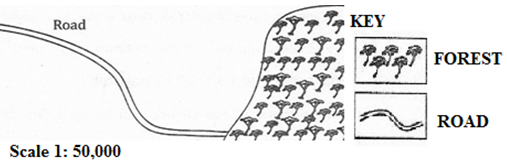
- Name the type of scale which has been used to represent this map.
- Mention three ways which can be used to measure the distance of the road in the sketch map.
- Briefly describe three important basic components of a map.
- Convert the given scale into a statement.
- Mention three methods which can be used to calculate the area of the forest shown on the sketched map.
6.(a) Outline four ways of determining direction of a place on a map.
(b) List four features of the Representative Fraction (RF) scale.
(c) Suggest two ways of measuring areas with irregular shapes.
SECTION C
7.Describe five problems that face tourism industry in Tanzania.
8. Explain five problems that are facing the Rufiji basin project in Tanzania.
9. Explain five disadvantages of air transport to a country like Tanzania.
10. Describe five negative effects of crop cultivation to the environment.
FORM TWO GEOGRAPHY EXAM SERIES 27
FORM TWO GEOGRAPHY EXAM SERIES 27
THE PRESIDENT’S OFFICE MINISTRY OF EDUCATION, LOCAL ADMINISTRATION AND LOCAL GOVERNMENT
GEOGRAPHY- TERMINAL EXAMINATION-MAY
FORM TWO
TIME: 2:30HRS 2020
NAME: _______________________________________________ CLASS: _________
INSTRUCTIONS
- This paper consists sections A , B and C
- Answer All questions in section A and B and two(2) from section C
- All answers should be written in black or blue ink
SECTION A
Answer ALL questions in this section
MULTIPLE CHOICES QUESTIONS
1. For each of the following questions write the letter of the correct answer in the boxes provided below:
(i) An angular distance measured in degrees East and West of the Prime Meridian:-
- Equator
- Latitude
- Longitude
- Tropic of cancer
(ii) One of the common characteristics between nomadic pastoralism and shifting cultivation is that people have:
- Advanced in technology
- Good standard of living
- High crop production
- No permanent settlement
(iii) The wise use and control of water resources is known as water:
- Controlling
- Development
- Management
- Resources
(iv) Although the earth is in motion all the time we don’t feel its motion. This is due to the reason that we are:
- In the earth
- Moving against the motion
- Moving with it
- On the earth
(v) The major features rising above the surface of ocean water and important for tourism are called:
- Continental shelf
- Continental slope
- Ocean island
- Ocean plain
(vi) The solar eclipse occurs when:
- One body passes between the two bodies
- The earth passes between the moon and the sun
- The earth passes between the sun and the moon
- The moon passes between the earth and the sun
(vii) The farthest position of the earth from the sun is known as:
- Aphelion
- Equinox
- Perihelion
- Solstice
(viii) The occurance of summer, winter, autumn and spring is a result of:
- Ferrel’s law
- Revolution of the earth
- Tilting of the earth on its axis
(ix) The height above sea level is called
- Altitude
- Contours
- Latitudes
- Ocean
(x) Which one of the following was the smallest planet in the solar system?
- Earth
- Mercury
- Pluto
- Venus
2. Matching items. Select an item from group B and match it with the corresponding item in group A
| LIST A | LIST B |
| (i) Tourism (ii) Mining (iii) Trade and commerce (iv) Sedentary livestock (v) Physical landscape, atmosphere, natural vegetations
|
|
3. The following statements are either correct or incorrect. Write TRUE if the statement is correct or FALSE if the statement is not correct:
- Circumnavigation of the earth is not the evidence to prove that the earth is spherical ________________
- Crossing the international date line causes the gauzing or losing a day _______________
- Forests are sources of medicine ____________
- Geography deals with the earth’s features only ___________
- Light industries involve manufacturing of heavy and bulky products ___________
- The time within a particular area is termed as local mean Time (L.M.T) ___________
- Good railways and road networks stimulate economic development ___________
- Industrial activities have no negative impacts on environment _____________
- Lake Victoria is within the Rift Valley _____________
- Trenches and ocean deeps are the same relief features of the river basin ____________
4. (a)Define the term “temperature”
(b) Study carefully the climatic data given for station Y and then answer the questions that follow:
| Months | J | F | M | A | M | J | J | A | S | O | N | D |
| Temp(oC) | 28 | 27 | 27 | 27 | 28 | 28 | 26 | 25 | 24 | 26 | 27 | 28 |
| Rainfall(mm) | 2400 | 2100 | 2050 | 1750 | 1700 | 1750 | 1660 | 1500 | 1700 | 1805 | 2100 | 2300 |
- Calculate the annual mean temperature
- Calculate the amount of annual rainfall
- Determine the annual range of temperature
- Suggest the type of climate at station Y
SECTION B
Answer ALL questions in this section
5. (a) Briefly explain the concept of human activities.
(b) Name four types of primary human activities.
(c) Giving two examples, differentiate between primary and secondary human activities.
6. (a)Explain the term map
(b) With examples explain the following types of maps:
- Topographical maps
- Statistical maps
(c) Examine five (5) characteristics of a good map:
SECTION C
Attempt two questions
7. Discuss the significance of atmospheric pressure in life (5 points)
8. How walking long distance to the water sources affect the girl child? Explain (5 points)
9. Describe ways of improving subsistence small scale agriculture. (5 points)
10.(a) What is river basin development project?
(b) Examine the importance of river basin development projects in Africa (4 points)
FORM TWO GEOGRAPHY EXAM SERIES 17
FORM TWO GEOGRAPHY EXAM SERIES 17
PRESIDENT’S OFFICE MINISTRY OF EDUCATION AND REGIONAL GOVERNMENT
MID TERM EXAMINATION-APRIL-2020
TIME: 2:30HRS
NAME: _____________________________________CLASS: _________
INSTRUCTIONS
- This paper consists sections A , B and C
- Answer All questions in section A and B and two(2) from section C
- All answers should be written in black or blue ink
SECTION A
Answer ALL questions in this section
MULTIPLE CHOICES QUESTIONS
- For each of the following questions write the letter of the correct answer in the boxes provided below:
i) An angular distance measured in degrees East and West of the Prime Meridian:-
- Equator
- Latitude
- Longitude
- Tropic of cancer
ii) One of the common characteristics between nomadic pastoralism and shifting cultivation is that people have:
- Advanced in technology
- Good standard of living
- High crop production
- No permanent settlement
iii) The wise use and control of water resources is known as water:
- Controlling
- Development
- Management
- Resources
iv) Although the earth is in motion all the time we don’t feel its motion. This is due to the reason that we are:
- In the earth
- Moving against the motion
- Moving with it
- On the earth
v) The major features rising above the surface of ocean water and important for tourism are called:
- Continental shelf
- Continental slope
- Ocean island
- Ocean plain
vi) The solar eclipse occurs when:
- One body passes between the two bodies
- The earth passes between the moon and the sun
- The earth passes between the sun and the moon
- The moon passes between the earth and the sun
vii) The farthest position of the earth from the sun is known as:
- Aphelion
- Equinox
- Perihelion
- Solstice
viii) The occurance of summer, winter, autumn and spring is a result of:
- Ferrel’s law
- Revolution of the earth
- Tilting of the earth on its axis
ix) The height above sea level is called
- Altitude
- Contours
- Latitudes
- Ocean
x) Which one of the following was the smallest planet in the solar system?
- Earth
- Mercury
- Pluto
- Venus
- Matching items:
Select an item from group B and match it with the corresponding item in group A
GROUP A
i) Agriculture
ii) Tourism
iii) Mining
iv) Trade and commerce
v) Monoculture
vi) Sedentary livestock
vii) Water resource extraction
viii) Water resource conservation
ix) Mercuric Barometer
x) Physical landscape, atmosphere, natural vegetations
GROUP B
- Plantation agriculture
- Subsistence agriculture
- Travelling on business or leisure
- Just travelling
- Movement of people and goods
- Extraction of valuable minerals
- Buying and selling of goods
- Book-keeping and commerce
- Cultivation and livestock keeping
- Farming
- Fish and sea weeds
- Avoiding water wastage
- Atmospheric pressure
- Physical geography
- The following statements are either correct or incorrect. Write TRUE if the statement is correct or FALSE if the statement is not correct:
i) Circumnavigation of the earth is not the evidence to prove that the earth is spherical ________________________
ii) Crossing the international date line causes the gauzing or losing a day_______________
iii) Forests are sources of medicine____________
iv) Geography deals with the earth’s features only___________________
v) Light industries involve manufacturing of heavy and bulky products_________________
vi) The time within a particular area is termed as local mean Time (L.M.T)______________
vii) Good railways and road networks stimulate economic development_________________
viii) Industrial activities have no negative impacts on environment____________________
ix) Lake Victoria is within the Rift Valley_______________________
x) Trenches and ocean deeps are the same relief features of the river basin______________
- a)Define the term “temperature”
b) Study carefully the climatic data given for station Y and then answer the questions that follow:
| Months | J | F | M | A | M | J | J | A | S | O | N | D |
| Temp(oC) | 28 | 27 | 27 | 27 | 28 | 28 | 26 | 25 | 24 | 26 | 27 | 28 |
| Rainfall(mm) | 2400 | 2100 | 2050 | 1750 | 1700 | 1750 | 1660 | 1500 | 1700 | 1805 | 2100 | 2300 |
i) Calculate the annual mean temperature
ii) Calculate the amount of annual rainfall
iii) Determine the annual range of temperature
iv) Suggest the type of climate at station Y
SECTION B
Answer ALL questions in this section
- a)Define the term SEA BREESES
__________________________________________________________________________________________________________________________________
b) Study the diagram below then answer the questions that follows:-
i) The type of breeze shown on the diagram above is________________________
ii) A stands for_______________________
B stands for_______________________
C stands for_______________________
D stands for_______________________
E stands for_______________________
- a)Explain the term map
___________________________________________________________________________________________________________________________________________________________________________________________________
b) With examples explain the following types of maps:
i) Topographical maps
___________________________________________________________________________________________________________________________________________________________________________________________________
ii) Statistical maps
________________________________________________________________________________________________________________________________________________________________________________________________________________________________________________________________________________________________
c) Examine five (5) characteristics of a good map:
i) __________________________________________________________________________________________________________________________________
ii) __________________________________________________________________________________________________________________________________
iii) __________________________________________________________________________________________________________________________________
iv) __________________________________________________________________________________________________________________________________
v) __________________________________________________________________________________________________________________________________
SECTION C
Attempt two questions
- Discuss the significance of atmospheric pressure in life (5 points)
- How walking long distance to the water sources affect the girl child? Explain (5 points)
- Describe ways of improving subsistence small scale agriculture. (5 points)
- a) What is river basin development project?
b) Examine the importance of river basin development projects in Africa (4 points)
BEST WISHES
FORM TWO GEOGRAPHY EXAM SERIES 9
FORM TWO GEOGRAPHY EXAM SERIES 9
THE MINISTRY OF EDUCATIO AND VOCATIONAL TRAINING
FORM TWO MID TERM EXAMINATIONS- MARCH 2020
013 GEOGRAPHY
Duration: 2:30 Hours
INSTRUCTIONS.
- This paper consists of sections A, B and C with a total of ten (10) questions.
- Answer all questions in section A and B and two (2) questions from section C
- All writing must be in blue or black ink.
- All answers must be written in the space provided.
- Calculators, cellular phones and any unauthorized materials are not allowed in the examination room.
- Write your Examination Number at the top right corner of every page.
SECTION A (25 Marks)
Answer all questions in this section.
1. For each of the items (i) � (ii), choose the correct answer from among the given alternatives and write its letter in the box provided.
i. Which of the following is not an aspect of geography?
- Map reading and photography
- Different land forms
- Human and economic activities
- Human rights.
ii. Major natural regions of the world can also be called?
- Ocean current regions
- Weather regions
- Mountainous regions
- Climatic regions.
iii. Which one of the following is not a factor to consider while deciding the climate of a place?
- Prevailing winds
- Annual rainfall
- Distance from the ocean
- Annual range of temperature.
iv. The direction to which compass needle points is called
- Magnetic north
- True north
- Grid north
- Compass bearing
v. Cultivation of cash crops based on application of advanced technology is called?
- Subsistence agriculture
- A large scale agriculture
- Mixed system agriculture
- A small scale agriculture
vi. The condition of the atmosphere recorded for a short period of time is known as
- Climate
- Rainfall
- Weather
- Temperature
vii. Intensive farming means:-
- Large amount of capital or labour are applied in a small piece of land
- Large amount of capital is not used for a very large piece of land.
- Very small piece of land is cultivated locally.
- Subsistence farming basically for food supply in the family.
viii. Extensive farming can be defined as:-
- Horticulture production in a small piece of land
- Large area of land are worked by a small labour force.
- Commercial farming where production is intended for sale and food.
- Farming whereby people move from one place to another seasonally.
ix. The most common and perhaps the most important of socio � economic activities include:-
- Pastoralism, cultivation and trading activities
- Agriculture, trade and cultural activities.
- Arts, crafts and ceramics
- Recreation, initiation and traditional healing
x. The coastal zone people are involved in which type of human activities?
- Fishing, trading and small scale agriculture
- Lumbering, trading and hand crafts
- Initiation, recreation and social activities.
- Lumbering, mining and small scale agriculture.
2. Match the items in column A with those in column B by writing the letter of the correct answer against its corresponding item number in column A.
FORM TWO GEOGRAPHY EXAM SERIES 5
FORM TWO GEOGRAPHY EXAM SERIES 5

DOWNLOAD LEARNING HUB APP NOW

SORRY, YOU CAN'T VIEW THIS MARKING SCHEME PLEASE DOWNLOAD LEARNING HUB APP FROM PLAYSTORE TO GET FULL ACCESS TO ALL MARKING SCHEME!!
Click Here To Download Learning Hub Tanzania App
SAMAHANI, HUWEZI KUFUNGUA MAJIBU YA MTIHANI, TAFADHALI PAKUA APP YA LEARNING HUB TANZANIA ILI KUWEZA KUFUNGUA MAJIBU YA MITIHANI KATIKA TOVUTI HII!!
Bofya Hapa Kupakua App Ya Learning Hub Tanzania
Hub App
 For Call,Sms&WhatsApp: 255769929722 / 255754805256
For Call,Sms&WhatsApp: 255769929722 / 255754805256  Matokeo Darasa VII 2025
Matokeo KIDATO CHA II 2024
Matokeo Darasa IV 2024
SECONDARY REGIONAL EXAMS
PRIMARY REGIONAL EXAMS
FORM VI NECTA REVIEWS
FORM IV NECTA REVIEWS
FORM II NECTA REVIEWS
STD VII NECTA REVIEWS
STD IV NECTA REVIEWS
SECONDARY EXAMS SERIES
PRIMARY EXAMS SERIES
PRIMARY SUBJECT NOTES
SECONDARY SUBJECT NOTES
SECONDARY TOPICAL EXAMS
SECONDARY TOPICAL QUESTIONS
PRIMARY TOPICAL QUESTIONS
PRACTICAL EXAMS & NOTES
SECONDARY REGIONAL EXAMS
DOWNLOAD SUBJECT NOTES
SCHEMES OF WORK (PRIMARY & SECONDARY)
LESSON PLAN
SECONDARY LOG BOOKS
PRIMARY LOG BOOKS
LITERARY WORKS / UCHAMBUZI VITABU
METHALI ZOTE ZA KISWAHILI
Vitendawili Vya Kiswahili
FORM VI RESULTS 2024
FORM FIVE SELECTION 2024
MATOKEO KIDATO CHA IV 2023
FORM ONE SELECTION 2024
FORM VI RESULTS 2023
Matokeo Darasa IV 2022
Matokeo Darasa VII 2025
Matokeo KIDATO CHA II 2024
Matokeo Darasa IV 2024
SECONDARY REGIONAL EXAMS
PRIMARY REGIONAL EXAMS
FORM VI NECTA REVIEWS
FORM IV NECTA REVIEWS
FORM II NECTA REVIEWS
STD VII NECTA REVIEWS
STD IV NECTA REVIEWS
SECONDARY EXAMS SERIES
PRIMARY EXAMS SERIES
PRIMARY SUBJECT NOTES
SECONDARY SUBJECT NOTES
SECONDARY TOPICAL EXAMS
SECONDARY TOPICAL QUESTIONS
PRIMARY TOPICAL QUESTIONS
PRACTICAL EXAMS & NOTES
SECONDARY REGIONAL EXAMS
DOWNLOAD SUBJECT NOTES
SCHEMES OF WORK (PRIMARY & SECONDARY)
LESSON PLAN
SECONDARY LOG BOOKS
PRIMARY LOG BOOKS
LITERARY WORKS / UCHAMBUZI VITABU
METHALI ZOTE ZA KISWAHILI
Vitendawili Vya Kiswahili
FORM VI RESULTS 2024
FORM FIVE SELECTION 2024
MATOKEO KIDATO CHA IV 2023
FORM ONE SELECTION 2024
FORM VI RESULTS 2023
Matokeo Darasa IV 2022


