THE UNITED REPUBLIC OF TANZANIA PRESIDENT'S OFFICE REGIONAL ADMINISTRATION AND LOCAL GOVERNMENT KIGOMA DISTRICT COUNCIL
FORM TWO MOCK EXAMINATION
013. GEOGRAPHY
TIME: 2: 30 HRS 19.05.2025
Instructions
- This paper consists of sections A,B and C with total of ten (10) questions
- Answer all questions
- Section A and C carries fifteen (15) marks each and section B carry seventy (70) marks
- All writing must be in blue or black ink ink except for drawing must be in pencil.
- Cellular phones, calculators and any an authorized materials are not allowed in the examination room
- Write your examination number on every page.
SECTION A (15 marks)
1. For each of the following items choose the correct answer from the given alternatives and write its letter in table provided
i. A mountaineer was climbing up the kilimanjaro mountain he felt colder as he moved up. What geographical term used describe the situation.
- Temperature invasion
- Temperature change
- Temperature lapse rate
- temperature increase
ii. What types of rainfall occur when the warm moist wind from the ocean is forced to rise up by the mountain?
- Orographic rainfall
- conventional rainfall
- Frontal rainfall
- Cyclonic rainfall
iii. Malagarasi river is located at North East from Kasulu town . Identify the correct bearing of that river from Kasulu town.
- 22.5°
- 225°
- 45°
- 135°
iv. In Western Europe , forests shed their leaves during Autumn season. Which type of forest is found in that area ?
- coniferous forests
- Tropical forests
- Mangroves forests
- Deciduous forests
v. If the temperature at Karatu 800m is 28â—¦C. What will be the temperature at Morogoro 1400m above the sea level.
- 40.0°C
- 31.6°C
- 24.4°C
- 24.3°C
vi. Which set of elements of weather are mainly used to classify climate of an area?
- Humidity and precipitation
- Temperature and rainfall
- Temperature and sunshine
- Temperature and Humidity
vii. Mr. Nchabilonda prefers mostly to cultivate vegetables, maize and beans in his farm. What type of farming is he practicing
- Bush fallowing
- Shifting Cultivation .
- Crop rotation
- Intercropping
viii. What is the longitude of Dakar ( Senegal ) whose local time is 9:00 am, when the local time at Accra ( Ghana ) is noon?
- 30°E
- 30°W
- 45°E
- 45°W
ix. In Africa most farmers leave idle the exahausted piece of land for a certain period of time in order to gain its fertility, this agriculture technique is called
- bush fallowing
- Shift cultivation
- Sedentary farming
- Aquaculture
x) Mr. Masalakulangwa is a good farmer who likes much to practice only crop cultivation .What system does he undergo ?
- Transhumance farming
- Pastoral farming
- Arable farming
- Agricultural system
2. Match the description of categories of human activities in List A with their corresponding meaning in List B by writing the letter of the correct response below the item number in the table provided.
| LIST A | LIST B |
|
|
SECTION B (70 Marks)
3. The planet Earth is made up of land surface and water with different Land forms on both land and water found on continent and ocean
a)Identify five major features of the continents
b) Mention and explain three types of volcanoes as they form volcanic mountains
4. Study carefully the climatic data given for station X then answer the questions that follows
| Months | J | F | M | A | M | J | J | A | S | O | N | D |
| Temperature (0C) | 21.7 | 21 | 20.6 | 18.9 | 16 | 13.9 | 13.9 | 16 | 20 | 22.2 | 22.2 | 22.2 |
| Rainfall (mm) | 149.7 | 101.6 | 78.7 | 17.8 | 7.6 | 0 | 0 | 0 | 2.5 | 22.9 | 83.8 | 132 |
- Calculate the mean annual temperature for station x
- Calculate the annual total rainfall for station x.
- Give the annual range of temperature for station x.
- With two reasons suggest the type of climate for the station x. .
- Mention two the economic activities taking place
5. Our Geography teacher says that in Tanzania Meteorological Agency (TMA) weather station is very important matter, mention five factors considered when establishing weather station:
6. Large number of Tanzanians engage in small scale crops cultivation, they spend much of time in cropping but they get low yield. As an agriculturalist. List five ways which could advice them to use in order to improve their production.
7." Despite the fact that , Hydro-Electric Power (HEP) is an environmental friendly , but still it has damaging effects on the environment " . With five points justify this statement.
8. Amina is as good map marker one day she drew a good map of East Africa.
(a)Mention five major components that Amina indicated on that map.
(b) A good map must have a scale.
(i) Mention two uses of the scale on a map
(ii) With Example, show three ways of expressing the scale on a map.
9. Our president Hon. Dr. Samia S. Hassan emphasize Tanzanians in planting trees for the betterments of our animals as well as human beings also introduce different ministries for keeping and managing forest resources. Briefly explain five (5) social and economic importance of forest to human beings.
SECTION C (15 Mark)
10. The form two students visited at UJAMAA VILLAGE to see how the villagers conduct small scale farming system and found out many problems facing them in that activity . Explain five ways on how you will help them to solve the problems facing small scale farming system in their daily life.
FORM TWO GEOGRAPHY EXAM SERIES 119
FORM TWO GEOGRAPHY EXAM SERIES 119
Student's Assessment Number. . . . . . . . . . . . . . . . . . . . . . . . . .
THE UNITED REPUBLIC OF TANZANIA, REGIONAL ADMINISTRATION AND LOCAL GOVERNMENT

MADABA DISTRICT COUNCIL
MOCK EXAMINATIONS – 2025
FORM II
013 – GEOGRAPHY
TIME : 2:30 Hours July 17th 2025 p.m
INSTRUCTIONS
- This paper consists of sections A, B and C with a total of ten (10) questions.
- All answers must be written in the spaces provided.
- All writing should be in blue or black ink EXCEPT diagrams that should be drawn in pencil
- Write your number on every page of your paper
- All communication devices, Bibles and any unauthorized materials are not allowed in the examination room
| FOR ASSESSOR’S USE ONLY | ||
| QN. NUMBER | SCORE | ASSESSOR'S INITIAL |
| 1. | ||
| 2. | ||
| 3. | ||
| 4. | ||
| 5. | ||
| 6. | ||
| 7. | ||
| 8. | ||
| 9. | ||
| 10. | ||
| TOTAL | ||
| CHECKER’S INITIALS | | |
SECTION A (15 MARKS)
Answer all questions in this section
1. For each of the item (i-x), choose the most correct answer from the given alternatives and write its letter in the box provided below.
i. The students of form one were debating on overhead sun date at the tropic of cancer, they didn’t have conclusion about it. As a form two student which will be your correct answer among these?
- 22nd December
- 21st June
- 23rd march
- 22nd November
ii. Mwanaisha was making a geographical survey in different parts of Tanzania landforms. She was very much interested in a large – lying area of land that was surrounded by high grounds. Which landform does that person interested with?
- Plains
- Valley
- Mountain
- Basin
iii. Taifa stars scored first goal against Algeria at 7:10pm at Mkapa stadium in Dar –es-salaam (150E).At what time the goal observed in Algeria (450W) where some Tanzanians were watching the same game?
- 11:10pm
- 11:10am
- 10:00am
- 03:10pm
iv. Mr.Bakari was working at Motisun Group manufacturing in Dar-es-salaam dealing with production of iron and steel and yet he faces with serious loss of hearing, mental illness even heart failure. What kind of pollution does Mr.Bakari made him to suffer like that?
- Land pollution
- Air pollution
- Solid pollution
- Noise pollution
v. Which natural forest type consists of deciduous trees that shed their leaves during the dry season and located beyond the equatorial regions between 100 to 250 north and south of equator?
- Tropical rain forest
- Deciduous forest
- Tropical monsoon forest
- Coniferous forest
vi. The environmentalists’ emphasis the people on the use of the heat energy generated and stored in the earth that involves pumping cold water into hot rocks boreholes and extracting the steam through other borehole. Which is the best energy source to explain this statement?
- Natural gas
- Hydro-electric water
- Nuclear energy
- Geothermal energy
vii. Mwamvita is living in a zone lying between latitudes 100 north and 100 south of the equator and she always experiences distinct atmospheric circulation system of high and low pressure. Which global pressure belt belongs to that area?
- Polar high pressure belt
- Sub-polar low pressure belt
- Inter-tropical convergence belt
- Sub- tropical high pressure belt
viii. Form two students get confused about the activities that involve provision of intelligent services and information. Which level of human activity is this?
- Quaternary activities
- Primary activities
- Tertiary activities
- Quinary activities
ix. Majimoto is a village named after the river developed as a result of hot water flowing violently out of the ground into the atmosphere before falling on the earth surface. What is the suitable term that explain this scenario?
- Hot springs
- Geyser
- Juvenile water
- Connate
x. Amina and Asha were required to calculate a distance of road from their homestead to school in kilometers provided that, the map scale 1:50,000 and the distance measured on the map was 10cm.what will be the actual ground distance presented by them?
- 20km
- 10km
- 5km
- 15km
| i | ii | iii | iv | v | vi | vii | viii | ix | x |
| . |
2. Match the concept in LIST A with the response in LIST B by writing the letter of the correct response beside the item number in the space provided below.
| LIST A | LIST B |
| (i) The great circle around the middle of the globe dividing the earth into two equal parts (ii) The position of a point on the earth’s surface in relation to the equator, expressed as it’s angular distance north and south from the equator (iii) Either half of the earth’s sphere which has been divided by an equatorial plane through its Centre (iv) The standard line of the earth located at 00 longitude dividing the earth east and west into two equal parts (v) The angular distance of a given point measured in degrees east or west of Greenwich meridian |
|
Answers
| List A | i | ii | iii | iv | v |
| List B |
SECTION B (70 MARKS)
Answer all questions in this section
3. People from Lushoto hamlet in Tanga village always attend to the markets to get their basic needs by walking along the road. As a form two student;
(a) Name the type of transport predominantly used in that area
(b) What mode of transport do they use?
(c) Point out any four advantages of the mode of transport identified in (b) above.
(d) Identify any four (4) limitations of the mode of transport identified in (b) above.
4. Sir Kapinga is teaching for one student about ocean as large water body that surrounds the land mass
(a) List down five major oceans in the world.
(b) Mentioned three factors that affect the salinity of ocean water.
(c) . List down two features of ocean floor .
5. Mr.Mkujani is a famous in rearing animals for purpose of selling their products such as meat, milk, wool and hides. As competent form two student;
(a) What is the system of livestock keeping exercised by him?
(b) What are three possible characteristics of the identified type of livestock keeping in (a)
(c) What are three challenges encountered by Mr.Mkujani under this type of livestock keeping?
(d) Suppose you are selected by your class teacher to educate Mr.Mkujani basing on the challenges facing him so as to get best yields from his animals. What will be your arguments? Use three points.
6. (a) Suppose you are given a map extracted from MWANZA so as to identify various methods used to show nature of landscape or relief of an area. Name any four (4) Methods that could be used
(b) Use the knowledge acquired in the class to teach your fellow form one student to convert 1:750,000 into statement scale.
(c) Always information on a map is represented using symbols and signs with no ability of reading and interpreting them are meaningless. Use the knowledge acquired in the class to draw the following items.
| SIGN | SYMBOL |
| (a) Church | (b) Power Line |
| (c) Mountain | (d) Railway |
| (e) School | (f) River |
7. Carefully study the data below and answer the questions that follows.
| Months | J | F | M | A | M | J | J | A | S | O | N | D |
| Temp (0C) | 28 | 27 | 28 | 24 | 27 | 28 | 29 | 28 | 28 | 29 | 30 | 30 |
| Rainfall (mm) | 200 | 150 | 190 | 140 | 160 | 200 | 202 | 112 | 226 | 130 | 300 | 250 |
Questions:
(i) Calculate the total rainfall of the last six months from the given data .
(ii) Find the temperature range of the given data .
(iii) Calculate the mean temperature of the given data .
(iv) With two reasons identify the type of climate of the given data.
8. Priska is a form two student in Mbinga district, she got confused after being heard news on the radio that now days the degree of hotness and coldness is highly affected by number of factors
(a) Name the phenomenon that confused Priska
(b) List down four (4) factors that affect the phenomenon that you have mentioned above
9. Some terms used in major features of the earth looks like twins but differ. As a form two student, demonstrate your level of understanding to distinguish them with any two clear examples.
(a) Isthmus and Strait
(b) Block mountain and Fold mountain
(c) Plains and Plateaus
(d) Grabens and Basins
SECTION C (15 MARKS)
Answer the following question.
10. River basin is established for multipurpose project focusing on sustainable utilization of the area within the basin. Justify this statement with six (6) points.
FORM TWO GEOGRAPHY EXAM SERIES 112
FORM TWO GEOGRAPHY EXAM SERIES 112
 | THE UNITED REPUBLIC OF TANZANIA PRESIDENT’S OFFICE, REGIONAL ADMINISTRATION AND LOCAL GOVERNMENT KALIUA DISTRICT COUNCIL FORM TWO PRE – MOCK DISTRICT JOINT EXAMINATION - MAY 2024 |  |
GEOGRAPHY
TIME: 2:30HRS
INSTRUCTIONS
- This paper consists of three(3) sections A, B and C with a total of ten (10) questions
- Section A carries fifteen (15) marks, section B seventy (70) marks and section C fifteen (15) marks.
- Answer ALL questions in all sections
- Write your names and stream on the top center in every page of your examination
- ALL answers should appear in this question paper in the space provided.
SECTION A
1. For each of the items (i)-(x) choose the correct answer from among the given alternative and write its letter besides the item number in the answer booklet provided. (@1mark=10 marks)
i. Most of African societies are famous in moving with their livestock in search for water and pasture. Which among of the following are the examples of pastoralists’ societies in East Africa?
- Ngoni, Sukuma and Maasai
- Sangu, Kwavi and Hehe
- Sukuma, Gogo and Nyamwezi
- Maasai, Barbaig amajong
ii. The following below is the general term which refers to all things that attract tourists such as national parks, museums, good infrastructure and historical site?
- Tourism areas
- Tourism
- Tourists
- Tourism honey pot
iii. The keeping of livestock in Australia is mostly done in ranches where small pieces of land are prepared so as the livestock can be fed systematically to avoid overgrazing. These pieces of land prepared are commonly known as ..
- Paddocks
- Paddies
- Ranch
- Sheds
iv. Teaching is one of the examples of human activities that are performed in Tanzania by teachers. What kind of human activity performed by these people?
- Primary activity
- Tertiaryactivity
- Secondary activity
- Quaternary activity
v. The announcements about the trend of Covid 19 were announced in USA 56oW at 02:00p.m. At what longitude did Tanzanians supposed to listen the announcements if it was 08:24 p.m?
- 96oW
- 152oE
- 40oE
- 152oW
vi. Places in the East of Greenwich experience sun rise before places in the West because earth .
- Rotates from east to west
- Rotates from west to east
- Is very far from the sun
- Is very close to the sun
vii) The following are the measures to improve small scale agriculture in Tanzania except
- Establishing of cooperatives that can assist farmers
- Provision of soft loans for improved investment in agriculture
- Encouraging farmers to adopt plantation agriculture in rural areas
- Educating farmers on good farming techniques
viii. One of the form four students was wondering what causes the seasons of the year, you as a form one class who has been taught the causes of the seasons. What are the two causes would you explain to this student?
- Rotation and revolution
- Revolution and earth’s orbit of the earth’s axis
- Rotation and inclination of the earth’s axis
- Revolution and inclination
ix. Kigogo had a map which had lines on it joining various places with the same amount of clouds. The name of lines on Kigogo’s map are geographically called:
- Isonephs
- Isotherms
- Isokinetics
- Isobars.
x. The sun appears overhead at the equator twice a year 21st march and 21st June. These periods are commonly known as
- Summer and winter equinoxes
- Spring and summer equinoxes
- Spring and autumn equinoxes
- Winter and spring equinoxes
2. Match the following geographical events in LIST A with their corresponding dates in LIST B by writing the Letter of correspondence item in the box provided below (@1mark=5marks)
| LIST A | LIST B |
|
|
SECTION B 70 MARKS
Answer ALL questions in this section
3. Mr. Mabala had a farm, but he always used to cultivate maize. As time went on he wondered why the harvests were decreasing without knowing that monoculture was the problem. You as a form two student who knows different proper methods of farming, Piefly explain to him with five (5) of them so that he can continue having high production. (@2marks=10marks)
4. Carefully study the map extract of KILACHA HILL and answer the questions that follow
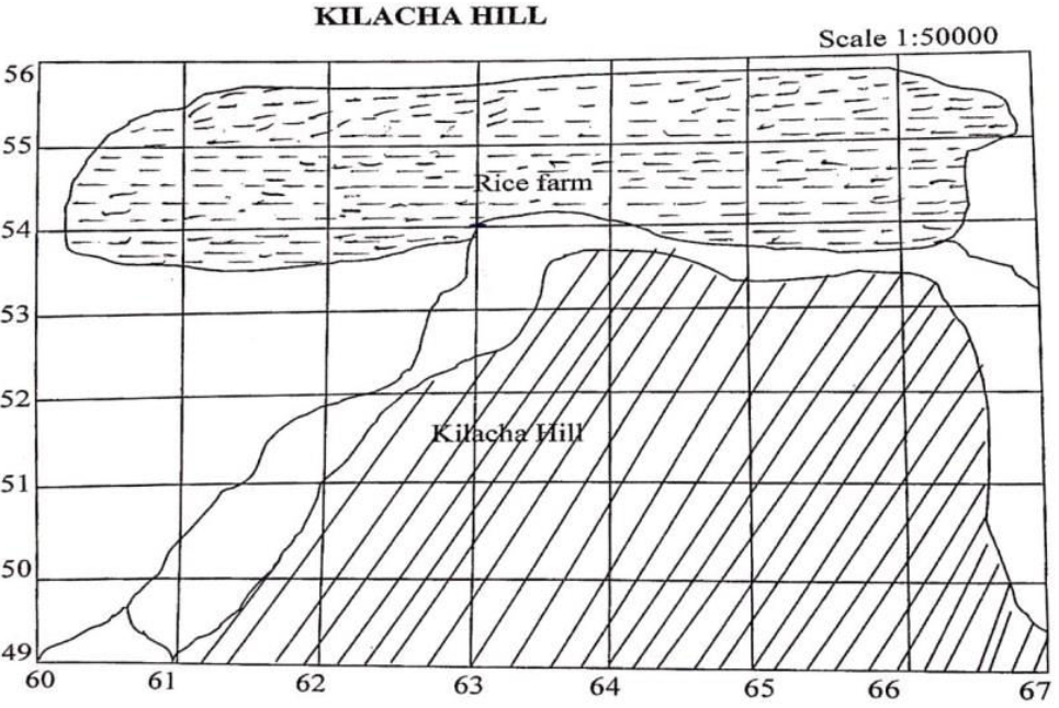 |
- Calculate the area covered by rice farm in KM2 given that the side of one is 2 centimeters ( 4marks)
- Mention two essentials that have been applied to draw that sketch map above (each 1 mark=2marks)
- Find the bearing and direction of grid reference 620500 from 650550 (2marks)
- Mention two (2) methods that can be used to locate position on the given sketch map. (2marks)
5. The process whereby water is transferred from the land to the air through plant roots and leaves vary from one place to another depends on the number of factors. You as an expert of this circumstance, briefly explain five (5) of them.
6. Always the oceanic floor is not uniform, it tends to vary from one place to another as it has different features. With this regard, draw a well labeled structure of the oceanic floor and indicate all eight (8) parts. (A good structure will weigh 2marks and well labeling, each 1mark=8marks)=10marks
7. (a) The establishment of an industry in a certain area depends on different issues. What makes different industries in Tanzania to be located where they are? Mention five (5) points.
(b) Minerals are useful in the growth of any country’s economy. List five (5) points to show how mining industries contribute to the economy of Tanzania.
8. (a) Convert the following scales according to the instructions given
- “One centimeter on the map represents two and half a kilometer on the ground”. Convert this scale into Representative fraction (R.F.) scale.
- 1:100000. Convert into statement scale.
- 1:50000. Convert into statement scale.
(b) State the compass direction for each of the following compass bearings.
- 280º ..
- 135º ..
- 45º ....
(c) How can the positions of objects be shown in any topographical map? Mention four(4) points.
9. Carefully study the data below and answer the questions that follow J
| Month | J | F | M | A | M | J | J | A | S | O | N | D |
| Temperature(oC) | 28 | 27 | 28 | 24 | 27 | 28 | 29 | 28 | 28 | 29 | 30 | 30 |
| Rainfall (mm) | 200 | 150 | 190 | 140 | 160 | 200 | 202 | 112 | 226 | 130 | 300 | 250 |
i. Calculate the total rainfall of the last six months of the given data (1 mark)
ii. Change the temperature range of the given data into degrees Fahrenheit (3 marks)
iii. Calculate the mean temperature of the given data (2 marks)
iv. With two reasons, identify the type of climate of the given data. (3marks)
Reasons
v. Mention two crops that may grow in the mentioned type of climate in 9(iv) above (each
SECTION C 15 MARKS
Answer the question given
10. The responsibility of fetching water in most Tanzanian societies is a cultural and gender-related activity in terms of who is responsible for fetching water and carrying it from the sources as it is for women and children especially girls. They travel a long distance to fetch water for domestic uses where they encountered with different problems. With six (6) points justify the truth of the statement.
FORM TWO GEOGRAPHY EXAM SERIES 106
FORM TWO GEOGRAPHY EXAM SERIES 106
Candidate’s number . . . . . . . . . . . . . . . . . . . . . .
 | PRESIDENT-OFFICE REGIONAL ADMINISTRATION AND LOCAL GOVERNMENT TANGANYIKA DISTRICT COUNCIL FORM TWO COUNCIL ASSESSMENTS – SERIES 1 |  |
013 GEOGRAPHY
TIME: 2:30 Hrs MARCH 2024
INSTRUCTIONS:
- This paper consists of section A, B and C with a total of Ten (10) questions.
- Answer all questions
- .Section A Carries 15 marks, section B 70 marks and section C carries 15 marks.
- All answer should be written in the answer sheet(s) provided.
- Any unauthorized materials are not allowed in the assessment room.
- Write your Assessment number at the top right corner of every page.
SECTION A (16 Marks)
Answer all questions from this section
1. For each of the items (i)-(x), choose the correct answer from the given alternatives and write its letters in the box provided
i. The angular distance measured in degree North and South of the equator is known as:
- Longitude
- Great circle
- Altitude
- Latitude
ii. If the temperature at Arusha 800m is 28 0C, what will be the temperature at Tanga 1400m above the sea level?
- 31.6 0C
- 24.5 0C
- 24.4 0C
- 40.0 0C
iii. The grid reference of station Y is 105190. What are the number of Eastings and Northing?
- 105 are Northings and 190 are Eastings
- 190 are Northings and 105 are Eastings
- 101 are Northings and 590 are Eastings
- 901 are Northings and 051 are Eastings
iv. The tourist from England to Tanzania were interested to visit mountains formed by prolonged denudation. Which types of mountains will satisfy their interest?
- Fold mountains
- Residual mountains
- Volcanic mountains
- Block mountains
v. Jane told her fellow students that, at their home place they are no longer moving with cattle for searching pasture and water but they now days keep small number of animals in permanent place. Which type of keeping are they practicing?
- Transhumance
- sedentary livestock keeping
- Nomadic pastoralism
- semi-nomadism
vi. A guest came to your school and ask for the location of headmaster’s house. One of the student said it found at east north east. The bearing of headmaster’s house is
- 270◦
- 112.5◦
- 67.5◦
- 337.5◦
vii. Mr. Jumbe was teaching his form one students about bodies that revolve around the planets. Name of these bodies are…
- Planets
- satellites
- comets
- asteroids
viii. The condition of the atmosphere recorded for a long period of time is known as;__
- Weather
- Rainfall
- Climate
- Temperature
ix. One of the following groups are features of the ocean floor.
- Ridge, basin, plateau and water falls
- Host, plain, basin and volcano
- Continental shelf, basin and waterfalls
- Trench, continental shelf and continental slope.
x. Identify the incorrect association in the following pairs
- Hygrometer and pressure.
- Wind speed and anemometer
- Isohyets and rainfall
- Rain gauge and rainfall
Match the items in list A with the corresponding one in list B by writing the letter of the correct response below the item number in the table provided.
| LIST A | LIST B |
|
|
SECTION B (70 MARKS)
Answer all questions in this section
3. You’re a form two student at Dakawa high school who does know the different meaning of geographical terms. Help form one student to explain the following concept
- Water management
- Crop rotation
- Eco- tourism
- Renewable energy resources
- Secondary activities
4. Carefully study the climatic data given for station Butiama village and then answer the question that follows
| Months | J | F | M | A | M | J | J | A | S | O | N | D |
| Temperature °C | 25 | 25 | 26 | 26 | 24 | 24 | 25 | 26 | 26 | 24 | 24 | 26 |
| Rainfall (mm) | 170 | 175 | 160 | 180 | 184 | 179 | 177 | 138 | 100 | 97 | 100 | 125 |
- Calculate the annual range of temperature
- Calculate the total amount rainfall
- Give the mean annual temperature
- Name the type of climate
- Suggest two (2) crops that can be grown
5. Most societies in different countries they do like to visit different of interest like (National Park, Historical sites, museums, beaches). Why Tourism has increased now days? Mention at least five points.
6. Assume you want to visit a certain place to learn different sources of water for different purposes or activities.
- List down five sources of water in your country
- Examine five uses of water sources
7. A Chinese investor is planning to invest in crop cultivation at your village, he wants to cultivate about 150 hectors.
- Name the type of crop cultivation that the investor is planning to do
- Mention three (3) characteristics of the kind of crop cultivation named in (a) above
- Mention four (4) advantages of the type of crop cultivation mentioned in (a) above
- Mention two (2) possible challenges that he might face in his investment
8. Manufacturing industry at your village are in a very scarcity for processing raw materials in order to make new products.
- Point out three factors influencing the location of this industry.
- Outline three effects of manufacturing industry in the environment
- How to improve these industries, mention at least four measures taken.
9. Imagine you are given a sketch map with the scale of 1:50,000, in the map there is Mtera dam which is irregular in shape, the dam has 5 complete squares, 13 incomplete squares, the side of one square is 2cm, the length of road from place A to place B is 15cm.
- Calculate the length of the road from place A to place B in kilometers
- Calculate the area of Mtera dam in Km2.
- Where could convectional signs and symbols used on the map get interpreted?
- Mention three ways that are suitable to use to calculate the area of Mtera dam.
SECTION C (15 Marks)
Answer question ten (10).
10. Transportation differs from communication but all in all are very important world widely. As a form two students explain types of land transport with vivid examples. (Five points).
FORM TWO GEOGRAPHY EXAM SERIES 90
FORM TWO GEOGRAPHY EXAM SERIES 90
Student’s Assessment Number . . . . . . . . . . . . . . . . . . . . . . . .
 | PRESIDENT’S OFFICE - RALG ROMBO DISTRICT EXAMINATION SYNDICATE (RODES) FORM TWO MOCK ASSESSMENT EXAMINATION |  |
013 GEOGRAPHY
Time 2.30 Hours August, 2024
- This paper consists of sections A, B and C with a total of ten (10) questions.
- Answer all questions.
- Section A and C carry fifteen (15) marks each and section B carry seventy (70) marks.
- All answers must be written in blue or black ink.
- Cellular phones, calculators and any unauthorized materials are not allowed in the examination room.
- Write your Examination Number at the top right corner of every page.
| FOR ASSESSORS’ USE ONLY | ||
| QUESTION NUMBER | SCORE | ASSESSORS' INITIALS |
| 1. | ||
| 2. | ||
| 3. | ||
| 4. | ||
| 5. | ||
| 6. | ||
| 7. | ||
| 8. | ||
| 9. | ||
| 10. | ||
| TOTAL | ||
| CHECKERS' INITIAL | ||
SECTION A (15 Marks)
Answer all questions in this section
1. For each of the items (i)–(x) choose the correct answer from among the given alternatives and write its letter beside the item number in the answer table provided.
(i) Geography has two major branches. These are:
- Geo and graphien
- Physical and human
- Primary and secondary
- Real and imaginary
(ii) The main source of energy on the earth is:
- Sun
- Solar energy
- Solar system
- Meteors
(iii) Long narrow deep and steep-sided depressions between parallel faults on the earth’s surface are called:
- Volcano
- Rift valleys
- River
- Ocean deep
(iv) The instrument used to measure the highest temperature between the readings is:
- Maximum thermometer
- Minimum thermometer
- Six’s thermometer
- Thermometer
(v) Which of the following is essential in measuring distance on maps?
- Scale
- Key
- Compass
- Frame
(vi) If temperature of Mpanda 1500m above the sea level is 20°C, what will be the temperature of Tumbatu Island which found on the sea level?
- 11°C
- 29°C
- 19.1°C
- 20.9°C
(vii) Which place will experience sunrise earliest on any day?
- Kasese (10°,30°E)
- Tanga (5°S,39°E)
- Kitale (1°N,35°E)
- Iringa (8°S,35°E)
(viii) A scale of 4cm representing 18km on the ground will be represented by representative fraction(R.F) scale as:
- 1:450,000
- 2:900,000
- 1:900,000
- 1:800,000
(ix) Given that the local time at Greenwich Meridianis12:00noon,what will be the local time at Mikindani which is 10°S40°E?
- 2.40a.m.
- 2.20 p.m.
- 2.40 p.m.
- 2.20a.m.
(x) The time increases by 4 minutes for every 1° of longitude when one travels from:
- North to South
- East to South
- West to South
- West to East
ANSWERS
| S/N | (i) | (ii) | (iii) | (iv) | (v) | (vi) | (vii) | (viii) | (ix) | (x) |
| ANS |
2. Match each item in List A with the correct response in List B by writing its letter below the number of the corresponding item in the answer table provided.
| LIST A | LIST B |
| (i) Occurs when the atmosphere becomes heated more than its surroundings leading to upward motion, rain falls from convective clouds like cumulonimbus clouds (ii) Occurs when masses of air with different density(moisture and temperature) meet, warmer air rises over cold air which produces precipitation (rain) (iii) It is caused when masses of air pushed by wind are forced up the side of elevated land formations like mountains (iv) Occur at night due to the fact that land temperatures drop faster than water (v) During the day the breeze comes from the sea because the land is warmer and air travels from areas of high pressure to areas of low pressure |
|
ANSWERS
| S/N | (i) | (ii) | (iii) | (iv) | (v) |
| ANSWERS |
SECTION B (70 Marks)
Answer all questions in this section
3 (a)There is enough evidence to show that the earth is not straight. As a future geographer list five evidences that indicates that the earth is not straight is spherical
(i) . . . . . . . . . . . . . . . . . . . . . . . . . . . . . . . . . . ...
(ii) . . . . . . . . . . . . . . . . . . . . . . . . . . . . . . . . . . ...
(iii) . . . . . . . . . . . . . . . . . . . . . . . . . . . . . . . . . . ...
(iv) . . . . . . . . . . . . . . . . . . . . . . . . . . . . . . . . . . ...
(v) . . . . . . . . . . . . . . . . . . . . . . . . . . . . . . . . . . ...
(b) The form one student at Mkuu secondary school debates on the ability to be allowed by the headmaster to drop Geography subject because they think it is useless. As form two student tell the form one the benefit of studying Geography
(i) . . . . . . . . . . . . . . . . . . . . . . . . . . . . . . . . . . ...
(ii) . . . . . . . . . . . . . . . . . . . . . . . . . . . . . . . . . . ...
(iii) . . . . . . . . . . . . . . . . . . . . . . . . . . . . . . . . . . ...
(iv) . . . . . . . . . . . . . . . . . . . . . . . . . . . . . . . . . . ...
(v) . . . . . . . . . . . . . . . . . . . . . . . . . . . . . . . . . . ...
4. Define the following terminologies:
(a) Bush following
. . . . . . . . . . . . . . . . . . . . . . . . . . . . . . . ....
. . . . . . . . . . . . . . . . . . . . . . . . . . . . . . . . . . . . . .
(B)Land reclamation
. . . . . . . . . . . . . . . . . . . . . . . . . . . . . . . . . . . . . . .
. . . . . . . . . . . . . . . . . . . . . . . . . . . . . . . . . . . . . .
. . . . . . . . . . . . . . . . . . . . . . . . . . . . . . . . . . . . . .
(c)Hydrological cycle . . . . . . . . . . . . . . . . . . . . . . . . . . . ..
. . . . . . . . . . . . . . . . . . . . . . . . . . . . . . . . . . . . . .
. . . . . . . . . . . . . . . . . . . . . . . . . . . . . . . . . . ...
. . . . . . . . . . . . . . . . . . . . . . . . . . . . . . . . . . . . . .
(d)Water pollution . . . . . . . . . . . . . . . . . . . . . . . . . . . . .
. . . . . . . . . . . . . . . . . . . . . . . . . . . . . . . .. . . . . .
(e)Tourism . . . . . . . . . . . . . . . . . . . . . . . . . . . . . . . .
. . . . . . . . . . . . . . . . . . . . . . . . . . . . . . . . . . . . . .
5. Despite the fact that; tourism sector in Tanzania has been very advantageous but it has been facing many challenges. Mention five (05) challenges.
i. . . . . . . . . . . . . . . . . . . . . . . . . . . . . . . . . . . . . . . .
ii . . . . . . . . . . . . . . . . . . . . . . . . . . . . . . . . . . . . . . . . . . . . . .
iii................. . . . . . . . . . . . . . . . . . . . . . . . . . . . . . . . . . . . . . . . . .
iv . . . . . . . . . . . . . . . . . . . . . . . . . . . . . . . . . . . . . . . . . . . . .
v . . . . . . . . . . . . . . . . . . . . . . . . . . . . . . . . . . . . . . . . . . . . . .
5. Carefully study the data below and answer the question that follow
| Month | J | F | M | A | M | J | J | A | S | O | N | D |
| Temperature (°C) | 28 | 27 | 28 | 24 | 27 | 28 | 29 | 28 | 28 | 29 | 30 | 30 |
| Rainfall (mm) | 200 | 150 | 190 | 140 | 160 | 200 | 202 | 112 | 226 | 130 | 300 | 250 |
(i) Calculate the total rainfall of the last six months of the given data
. . . . . . . . . . . . . . . . . . . . . . . . . . . . . . . . . . . . . . . . . . . . . . . . . . . . . . . . . . . . . . . . . . . . . . . . . . . . . . . . . . . . . . . . . . . .
(ii) Find the temperature range of the given data
. . . . . . . . . . . . . . . . . . . . . . . . . . . . . . . . . . . . . . . . . . . . . . . . . . . . . . . . . . . . . . . . . . . . . . . . . . . . . . . . . . . . . . . . . . . .
(iii) Calculate the mean temperature of the given data
. . . . . . . . . . . . . . . . . . . . . . . . . . . . . . . . . . . . . . . . . . . . . . . . . . . . . . . . . . . . . . . . . . . . . . . . . . . . . . . . . . . . . . . . . . . .
(iv)With two reasons identify the type of climate of the given data
- Type of climate . . . . . . . . . . . . . . . . . . . . . . . . . . . . . . . . . . . . . . . . . . . . . .
- Reasons . . . . . . . . . . . . . . . . . . . . . . . . . . . . . . . . . . . . . . . . . . . . . .
(v). Mention two crops that may grow in the mentioned type of climate in 6(iv)
- . . . . . . . . . . . . . . . . . . . . . . . . . . . . . . . . . . . . . . . . . . . . . .
- . . . . . . . . . . . . . . . . . . . . . . . . . . . . . . . . . . . . . . . . . . . . . .
7. Study the sketch map of KINCHWEMPYA provided below and answer the questions follow:
 |
(a) From the map provided, identify any four (4) essentials of map that can be seen.
(i) . . . . . . . . . . . . . . . . . . . . . . . . . . . . . . . . . . ...
(ii) . . . . . . . . . . . . . . . . . . . . . . . . . . . . . . . . . . ...
(iii) . . . . . . . . . . . . . . . . . . . . . . . . . . . . . . . . . . ...
(iv) . . . . . . . . . . . . . . . . . . . . . . . . . . . . . . . . . . ...
(b) Write the grid references of points A, B, C and D as located on the map.
A . . . . . . . . . . . . . . . . . . . . . . . . . . . . . . . . . . ...
B . . . . . . . . . . . . . . . . . . . . . . . . . . . . . . . . . . ...
C . . . . . . . . . . . . . . . . . . . . . . . . . . . . . . . . . . ...
D . . . . . . . . . . . . . . . . . . . . . . . . . . . . . . . . . . ...
(c) (i) Identify the type of scale shown on the map. . . . . . . . . . . . . . . . . ...
(ii) Name the method /ways used to provide the scale identified above
. . . . . . . . . . . . . . . . . . . . . . . . . . . . . . . . .
(iii) Change the scale given into the statement scale. . . . . . . . . . . . . . . . ..
. . . . . . . . . . . . . . . . . . . . . . . . . . . . . . . . . . ...
. . . . . . . . . . . . . . . . . . . . . . . . . . . . . . . . . . ...
8. Chausiku is form two students in Lindi region, she get confused after being heard News on the radio that now days the degree of hotness and coldness is highly affected by number of factors.
- Name the phenomenon that confused Chausiku . . . . . . . . . . . . . . . . . . . . . .
- List down four (04) factors that affect the phenomenon that you have mentioned above.
i. . . . . . . . . . . . . . . . . . . . . . . . . . . . . . . . . . . . .
ii. . . . . . . . . . . . . . . . . . . . . . . . . . . . . . . . . . . . .
iii. . . . . . . . . . . . . . . . . . . . . . . . . . . . . . . . . . . . .
iv. . . . . . . . . . . . . . . . . . . . . . . . . . . . . . . . . . . . .
9. As a geography we know that there are different instruments that used to measure the element of weather. Mention one function of the following instruments
| INSTRUMENT | USED TO MEASURE |
| (i) Barometer | |
| (ii) Anemometer | |
| (iii) Hydrometer | |
| (iv) Thermometer | |
| (v) Sunshine recorder |
SECTION C (15 Marks)
Answer the question ten (10) below
10. Anna's grandmother used to cultivate many crops in a small area using local seeds, hand hoe, and manure. She is now blaming that in five years the harvest are poor. She is complaining that her neighbors are the ones causing it. With five points explain to her how she can improve her farming system
FORM TWO GEOGRAPHY EXAM SERIES 85
FORM TWO GEOGRAPHY EXAM SERIES 85
CHRISTIAN SOCIAL SERVICES COMMISSION- (CSSC)

WESTERN ZONE
FORM TWO JOINT EXAMINATION
CODE: 013 GEOGRAPHY
TIME2:30HRS Date: 28th August, 2023
INSTRUCTIONS
- This paper consists of sections A, B and C with a total of ten (10) questions.
- Answer all questions.
- Section A and C carry fifteen (15) marks each and section B carries seventy (70) marks.
- All writing must be in blue or black ink.
- All writing must be written in the space provided.
- Cellular phones, calculators and any unauthorized materials are not allowed in the assessment room.
- Write your Assessment Number at the top right corner of every page.
| FOR ASSESSOR’S USE ONLY | ||
| QUESTION NUMBER | SCORES | ASSESSOR’S INITIALS |
| 1 | ||
| 2 | ||
| 3 | ||
| 4 | ||
| 5 | ||
| 6 | ||
| 7 | ||
| 8 | ||
| 9 | ||
| 10 | ||
| TOTAL | ||
| CHECKER’S INITIALS | ||
SECTION A (15 Marks)
Answer all questions.
1. For each of the items (i-x), choose the correct answer from the given alternatives and write its letter in the box provided.
i. What type of rainfall occurs when the warm moist wind from the Indian ocean comes into contact with the cold air mass from the land mass?
- Orographic rainfall
- Convectional rainfall
- Frontal rainfall
- Cyclonic rainfall
ii. Mr. Mandongais a farmer who prefers to cultivate one out of his ten hectares which are located in place leaving the nine hectares uncultivated in order to regain back soil fertility. Which farming method is Mr. Mandonga practicing?
- Bush following
- Crop Rotation
- Advection rainfall
- Strip cropping
iii. John was told by his teacher that the earth makes one complete rotation every twenty four hours. From which direction does it rotate?
- West to East
- South to North
- North to South
- East to West
iv. Mpoki is a form one student at Mungukanipa Secondary school. During holiday, he went to Dar es Salaam to visit his aunt. While in journey he was surprised to experience uneven change of temperature from warm to cold. What do you think was happening at that moment?
- Weather Change
- Climatic Change
- Weather Forecasting
- Seasons of the year
v. It is believed that the NMB bank is the bank of all Tanzanians since it is available mostly of the places in Tanzania, under which category of human activities the services provided by this bank rely
- Primary Activities
- Secondary Activities
- Tertiary Activities
- Quaternary Activities
vi. Anna and Asha were required to calculate a distance of a road on map in Kilometers provided that; the map scale was 1: 50,000 and the distance measured on the map was 10cm. Which among the following was the actual distance presented by them?
- 10km
- 5km
- 15km
- 20km.
vii. If the temperature for Dar es Salaam at the sea level is 300 C, what is the temperature
- 31.20 C
- 28.20 C
- 30.20 C
- 32.20 C
viii. The grid reference X is 126169. What are the Eastings and Northings?
- 169are Northings and 126 are Eastings
- 126 are Northings and 169 are Eastings
- 621 are Eastings and 961 are Northings
- 619 are Eastings and 9612 are Northings
ix. What is the longitudinal location of Mogadishu whose local time is 4: 40 pm when the local time at Tunis 100 E is 2:20 pm?
- 35W
- 45E
- 60W
- 90E
x. Which of the following is an example of Residual Mountain in Tanzania?
- Mount Sekenke
- Mount Kilimanjaro
- Mount Ruwenzori
- Mount Meru
| Question | i | ii | iii | iv | v | vi | vii | viii | ix | x |
| Answer |
2. Match the items in LIST A with the correct response in LIST B by writing the letter of the correct response beside the item number.
| COLUMN A | COLUMN B |
|
|
Answers
| LIST A | i | ii | iii | iv | v |
| LIST B |
SECTION B (70 Marks)
Answer all questions.
3. (a) Amani was wondering to see the rain raining along the eastern slope of Mount Kilimanjaro leaving the west with rain shadow effect.
(i) Which type of rainfall was raining in the area?_____________________________________
(ii) With the aid of diagram show the type of rainfall experienced by Amani
(b) Ndimugwango is a new employee at Mtakuja Secondary School found in Tabora rural, he is in need of establishing his house in a swampy area but the ministry of land has advised him to transform the area into a very useful manner in order to ensure smooth construction process.
a. What is the general term to be used in the area likely to be transformed?
________________________________________________________________________
b. Identify four appropriate ways to be used in transforming the area
i. _________________________________________________________________
ii. __________________________________________________________________
iii. __________________________________________________________________
iv. __________________________________________________________________
4. (a) A form one student who believed that the earth is a sphere like structure was debating with a form two student who believed that the earth is in fact flat like a table, while debating their friend Marry proved to them that the earth is in fact sphere like structure. Using five points and relevant drawings comprehend to Mary’s belief in the sphericity nature of the planet earth.
(i) . . . . . . . . . . . . . . . . . . . . . . . . . . . . . . . . .
(ii) . . . . . . . . . . . . . . . . . . . . . . . . . . . . . . . . .
(iii) . . . . . . . . . . . . . . . . . . . . . . . . . . . . . . . . . .
(iv) . . . . . . . . . . . . . . . . . . . . . . . . . . . . . . . . . ...
(iv)
(v) . . . . . . . . . . . . . . . . . . . . . . . . . . . . . . . . . . .
4 (b) The National tourism board in Tanzania encourages much environmentally friendly tourism in order to conserve vulnerable natural eco-system for the betterments of Tanzanians.
i. What is the general name for the statement above?
________________________________________________________________________
ii. What are the four benefits that Tanzania is likely to get from the stated in (i) above?
a. __________________________________________________________________
b. ___________________________________________________________________
c. _____________________________________________________________________
d. _____________________________________________________________________
5. (a) Suppose you have been asked to calculate the area of the swamp of Tabora map extract having 10 complete squares, 8 incomplete squares and the map scale of 1:50,000 of which 1square is equal to 2cm.
(i) Change the map scale into statement scale
(ii) Calculate the total area of the swamp in Km2
5 (b) Apart from the map scale, list any four essentials of any good map
i. ___________________________________________________________________
ii. ___________________________________________________________________
iii. _____________________________________________________________________
(c) Point out four methods which may be used to determine relief of the mapped area:
i. __________________________________________________________________
ii. ____________________________________________________________________
iii. ____________________________________________________________________
iv. _____________________________________________________________________
6. During the holiday students of Mtakuja Secondary school had a field study tour to Ruaha river basin where they observed a power generating center at the base of water falls as a result of water rapids and water falls.
(a) Name the kind of energy and power generated in the area_____________________________
(b) Examine four conditions necessary for the generation of the energy and power named in (a) above.
i. ________________________________________________________________________
ii. ________________________________________________________________________
iii. ________________________________________________________________________
iv. ________________________________________________________________________
7. John’s family is engaging in forestry for their socio-economic benefits.
(a) Outline four benefits of which the family enjoys.
i. ___________________________________________________________________
ii. ___________________________________________________________________
iii. ______________________________________________________________________
iv. _______________________________________________________________________
(b) What is likely to happen if the existing forests in Tanzania are cleared away?
i. ________________________________________________________________
ii. __________________________________________________________________
iii. ___________________________________________________________________
iv. ____________________________________________________________________
8. Dear form two student, what will happen if
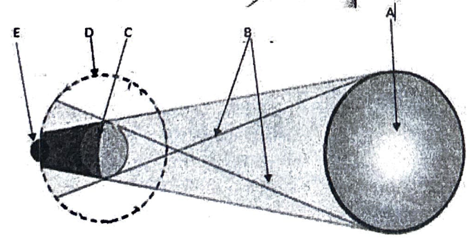
(i) The earth passes between the moon and the sun? ___________________________________
Support the given answer using a relevant diagram
(ii) If the moon passes between the sun and the moon?..............................................................
(ii) If the moon passes between the sun and the earth?..............................................................
Support using a diagram.
(b) What do you think are the four resultant effects of the earth’s rotation?
i. ____________________________________________________________________
ii. _____________________________________________________________________
iii. _____________________________________________________________________
iv. ______________________________________________________________________
9. (a) Point out five ways to which Tanzanians benefits from solar energy.
i. ____________________________________________________________________
ii. _______________________________________________________________________
iii. ________________________________________________________________________
iv. ________________________________________________________________________
(b) In which ways the Tanzania society benefits from weather forecasting?
Give five points
i. ____________________________________________________________________
ii. _____________________________________________________________________
iii. _____________________________________________________________________
iv. _____________________________________________________________________
v. _____________________________________________________________________
SECTION C (15 Marks)
10. Tanzania is one of the famous countries in the development of green tourism but this sector is blamed by the natives for resulting into several negative impacts by the foreigners. Using the knowledge, you have acquired in this topic, what are the six negative consequences of this sector?
FORM TWO GEOGRAPHY EXAM SERIES 70
FORM TWO GEOGRAPHY EXAM SERIES 70
THE UNITED REPUBLIC OF TANZANIA PRESIDENT'S OFFICE
REGIONAL ADMINISTRATION AND LOCAL GOVERNMENT
MOROGORO FORM TWO REGIONAL ASSESSMENT
GEOGRAPHY
CODE: 013
TIME: 2.30 HOURS YEAR: 2023
Instructions
- This paper consists of sections A, B and C with a total of ten (10) questions
- Answer all questions 3. Section A and C carry fifteen (15) marks each and section B carries seventy (70) marks
- All writing must be in blue or black ink
- All writing must be written in the space provided
- Cellular phones, calculators and any unauthorized materials are not allowed in the examination room
- Write your examination number at the top right corner of every page.
SECTION A (15 Marks)
1. For each of the items (i) - (x), choose the correct answer from the given alternatives and write its letter in the box provided.
i) Planets differ in distance from the sun, the following are the outer planets
- Mercury and Mars
- Mercury and Venus
- Earth and Jupiter
- Uranus and Neptune
ii) Suppose you planned to transport clean water from Ruaha river to Iringa city Centre, which means of transport will be suitable
- Road transport
- Railway transport
- Pipeline transport
- Water transport
iii) Traditional livestock keeping farming is practiced in areas where there is
- Very low rainfall
- Heavy rainfall
- No rainfall
- Low population
iv) The major source of energy which supports life and environment friendly is
- Electricity
- Candle wax
- Sun
- Coal
v) The grid reference of station X is 612825 what are number of Eastings and Northings
- 285 are Eastings and 612 are Northings
- 2285 are Northings and 6128 are Eastings
- 612 are Eastings and 825 are Northings
- 612 are Northings and 825 are Eastings
vi). A good example of Quaternary activities
- Fishing
- Teaching
- Scientific research
- Decision making
vii). Mayasa and Kasimu were assigned to draw the map of the school, which suitable type of scale they are supposed to use
- Large scale
- Small scale
- Medium scale
- Both scales
viii). The main elements of weather which are used to determine climate includes
- Rainfall and temperature
- Cloud and wind
- Temperature and humidity
- Humidity and wind
ix) In Mgagama village people have discovered the presence of minerals in area with water, as a form two student with adequate knowledge of mining which method would you advise people of Mgagama to use as mining method
- Underground method
- Shaft method
- Alluvial method
- Open cast method
x) The President of the United Republic of Tanzania came with idea of promoting tourism in Tanzania using Royal tour, as a form two student with awareness of tourism activities and how to protect our environment and values which approach would you advise our President and Minister to be used
- Domestic tourism
- International tourism
- Green tourism
- Socio-economic tourism
2. Match the diagram in list A with corresponding names in LIST B by writing the number of the correct response below the item number in the table provided
| List A | List B |
 |
|
Answers
| i | ii | iii | iv | v |
SECTION B (79 marks)
3. Study carefully the data recorded from Major weather station from 4 January 2023 to 11 January 2023 and answers the questions below:
| Day | Monday | Tuesday | Wednesday | Thursday | Friday | Saturday | Sunday |
| Temp C | 19 | 20 | 20 | 21 | 19 | 21 | 20 |
| Rain(mm) | 35 | 47 | 40 | 43 | 27 | 41 | 39 |
a) Calculate the weekly average temperatures in centigrade.
b) Compute the weekly rainfall in millimetres
c) Find temperature range with the week.
d) Which is the wettest day in a week? Why?
e) What were the coldest days in a Week? Why?
4. If the map has 14 complete square and 22 incomplete squares and the map scale given is 1:50000
a) Calculate the area
b) Mention three characteristics of a representative fractional scale
c) Kaombwe's grandfather is one of the Elders who owns large unusable areas of land in Dodoma, as a grandson of Kaombwe educate him on land reclamation methods so that he can turn his land to useful. (Give five points)
5. Kamwene and his friend were watching News on Television on weather fore casting, that tomorrow Morogoro region will experience high temperature;
a) As a form two student help Kamwene and his friend why situation did not change as it was expected (give three points)
b) Shortlist four elements of weather
6. During holiday Mkatakona travelled from Dar es salaam to Mbeya, but when she reached at Iringa she experienced different climate which differ from that of Dar es salaam and Morogoro,
a) as a form two student with knowledge on climate help Mkatakona to identify five causes of climate variation.
(b) Give five differences between climate and weather
7. You have given chance in village meeting to propose a location to build an industry, use the know edge you have gained while studying manufacturing industries t guide people in your village the right location to build an industry
a) Mention five points
b) In five past years the government of Tanzania has been motivating every region to build industries, these Industries have boosted the economy but also led to a lot of pollutants and waste, use the knowledge you have to advise the government on how to reduce pollutants (mention five points)
8. Mention five sources of renewable energy
9. John, a form two student from Mgudeni Secondary School was unable to differentiate some geographical terms; he decided to seek advice from his fellow students. As among of form two students, help John him to differentiate the following geographical terms,![]()
i) Plains and plateaus
ii) Umbra and penumbra
iii) Secondary and tertiary activities
iv) Natural forest and artificial forest
v) Solar energy and solar system
SECTION C (15 Marks)
Answer question ten
10. Shakira got a map of Tanzania showing forests, while studying it she was surprised to see some areas have dense forests, some have few forests and others have no forests. By giving examples explain to Shakira the causes of uneven distribution of forests in Tanzania.
FORM TWO GEOGRAPHY EXAM SERIES 62
FORM TWO GEOGRAPHY EXAM SERIES 62
Student’s Assessment Number…………………………………

 PRESIDENT’S OFFICE
REGIONAL ADMINISTRATION AND LOCAL GOVERNMENT
MVOMERO DISTRICT COUNCIL
FORM TWO MOCK EXAMINATION
CODE: 013 GEOGRAPHY
Time: 2:30 Hours May 2023
- This paper consists of sections A, B and C with a total of ten (10) questions.
- Answer all questions.
- Section A, C carry fifteen (15) marks each, and section B carries seventy (70) marks.
- All writing must be in blue or black ink.
- All writing must be written in the space provided.
- Cellular phones, calculators and any unauthorized materials are not allowed in the assessment room.
- Write your Assessment Number at the top right corner of every page.
| FOR ASSESSOR’S USE ONLY | ||
| QUESTION NUMBER | SCORE | ASSESSOR’S INITIALS |
| 1 |
|
|
| 2 |
|
|
| 3 |
|
|
| 4 |
|
|
| 5 |
|
|
| 6 |
|
|
| 7 |
|
|
| 8 |
|
|
| 9 |
|
|
| 10 |
|
|
| TOTAL |
|
|
| CHECKER’S INITIALS |
| |
SECTION A (15 Marks)
Answer all questions
- For each of the items (i-x), choose the correct answer from the given alternatives and write its letter in the box provided.
- John and Hamisi developed a strong debate on the shape of the earth. Hamisi argued that the shape of the earth is flat while John argued that the shape of earth is not flat. How can you help John to educate Hamisi?
- Round
- Flattened sphere
- Flat
- Sphere
- The local time at Greenwich Meridian is 10:30am on Thursday. What will be the time at longitude 180°E?
- 10:30am on Thursday
- 12:00pm on Thursday
- 12:30am on Wednesday
- 10:30 pm on Thursday
- Mpoki is a form student at Mtakuja Secondary School. During holiday, he went to Dar es Salaam to visit his uncle whom he took him to the beach. Mpoki supprissed when he saw a raised part of the ocean floor. How can you describe the feature that supprissed Mpoki?
- Mid-ocean ridge
- Ocean trench
- Continental shelf
- Continental slope
- The Grid reference Y is 364 595. What are the numbers of the Eastings and Northings?
- 595 are eastings and 364 are northings
- 364 are Eastings without Northings
- 364 are Eastings and 595 are Northings
- 955 are Northings and 463 are Eastings
- Suppose you are living in urban centre and you are interested in keeping livestock. What type of livestock keeping would be suitable for you?
- Transhumance
- Ranching
- Nomadism
- Sedentary
- Lilian who is astudent in form two class draw a map of Tanzania which her teacher complemented that its acomplete map which had all the qualities of being a map. What do you think that are the things lilian as aform two class student included or regarded while drawing that map?
- Key, small scale, title, margin and North direction
- Key, scale, margin, title and north direction
- Key, large scale, small scale, margin and title
- Key, scale, physical features and north direction
- The following diagram shows the sun, the earth and the orbit of the moon around the earth. Study it carefully and then answer the question that follow;
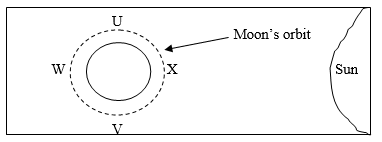
At which position of the moon is lunar eclipse likely to occur?
- w
- x
- u
- v
- The line from North Pole to South Pole through the centre of the earth is called……
- International Date Line
- Longitude
- Axis
- Horizon
- The vertical movement of the ocean water is known as……….
- Ocean currents
- Tide
- Tidal range
- Wave
- If the temperature for Dar es Salaam at the sea level is 30°c, what is the temperature for Moshi at 300m above the sea level?
- 31.2°C
- 28.2°C
- 30.2°C
- 32.2°C
- Match the description of weather concepts in List A with the correct response in List B by writing a letter of the correct response in the table provided.
| List A | List B |
|
|
Answers
| List A | i | ii | iii | iv | v |
| List B |
|
|
|
|
|
SECTION B (70 Marks)
Answer all questions
- a) What do you understand by the following geographical terms:
- Solar system……………………………………………………………………
……………………………………………………………………………………………………………………………………………………………………
- A map…………………………………………………………………………
……………………………………………………………………………………………………………………………………………………………………..
- Aphelion……………………………………………………………………………………………………………………………………………………………………………………………………………………………………………..
- Eclipse………………………………………………………………………………………………………………………………………………………………………………………………………………………………………………..
- Geographical phenomena……………………………………………………….
……………………………………………………………………………………………………………………………………………………………………
- When the earth rotates we do experience the changes.What are the result of those changes?( five (5) effects )
- …………………………………………………………………………………
- …………………………………………………………………………………
- …………………………………………………………………………………
- ………………………………………………………………………………
- …………………………………………………………………………………
- Complete the following sentences.
- Among the eight planets………………is the fifth planet in size.
- The branch of geography which deals with man-made features found on the earth’s surface is called……………………………………………………………………….
- John’s brother deals with map making as his work, what is his work?……………………………………..
- Angular distance measured East or West of Greenwich is known as…………………..
- A farming practice which involve cultivation of different types of crops in a farm year after year is called……………………………………………………………..
- a) List down any five (5) human activities that require geographical knowledge and skills.
- …………………………………………………………………………………..
- ………………………………………………………………………………….
- ………………………………………………………………………………….
- ……………………………………………………………………………..……
- …………………………………………………………………………….…….
- After studying geography we expect to obtain different job opportunities,Mention five (5) job opportunities that can be obtained .
- …………………………………………………………………………………
- …………………………………………………………………………………
- …………………………………………………………………………………
- …………………………………………………………………………………
- …………………………………………………………………………………
- The students were watching a video program showing people in a certain geographical area who cultivate a piece of land by using crude tools.
- Outline four (4) characteristics of such type of agriculture.
- …………………………………………………………………………………
- …………………………………………………………………………………
- …………………………………………………………………………………
- …………………………………………………………………………………..
- List down three (3) advantages of such type of agriculture
- …………………………………………………………………………………
- …………………………………………………………………………………
- …………………………………………………………………………………..
- Name three (3) disadvantages of such type of agriculture
- …………………………………………………………………………………
- …………………………………………………………………………………
- …………………………………………………………………………………
- “Water is life, no water no life”
- Justify the above statement by outlining four (4) points.
- …………………………………………………………………………………
- …………………………………………………………………………………
- …………………………………………………………………………………
- …………………………………………………………………………………
- There are several human activities that affect sources of water,list atleast three (3) human activities that affect water resource
- …………………………………………………………………………………
- …………………………………………………………………………………
- …………………………………………………………………………………
- List down three (3) ways of managing water resource
- …………………………………………………………………………………
- …………………………………………………………………………………
- …………………………………………………………………………………..
- Chausiku is form two student in Lindi Region, she get confused after being herd news on the radio that nowadays the degree of hotness and coldness is highly affected by a number of factors.
- Name the phenomenon that confused chausiku……………………………….
- List down eight (8) factors that affect the phenomenon you have mentioned above.
- ………..…………………………………………………………………………
- …………………………………………………………………………………
- …………………………………………………………………………………
- …………………………………………………………………………………
- …………………………………………………………………………………
- …………………………………………………………………………………
- …………………………………………………………………………………
- …………………………………………………………………………………
- …………………………………………………………………………………
- Study the sketch map provided and then answers the questions that follow.
![]()
![]()
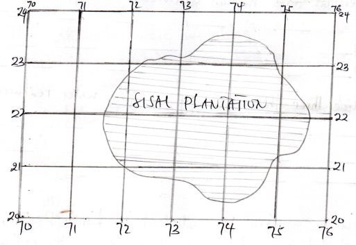
- Calculate the area covered by sisal plantation by using square method.
……………………………………………………………………………………………………………………………………………………………………………………………………………………………………………………………………………………………………………………………………………………………………………………………………………………………………………………………………..
………………………………………………………………………………………….
……………………………………………………………………………………………………………………………………………………………………………………
…………………………………………………………………………………………
………………………………………………………………………………………………………………………………………………………………………………………………………………………………………………………………………………………………………………………………………………………………………………………………………………………………………………………………………………………………………………………………………………………………………………………………………………………………………………………………………………………………………………………………………………………………………………………………………………………………………………………………………………………………………………………………………………………………………………………………………………………………………………………………………………………………………………………………..
…………………………………………………………………………………………………………………………………………………………………………………………………………………………………………………………………………………………………………………………………………………………………………………………………………………………………………………………………………………………………………………………………………………………………………………………………………………………………………………………………………………………………………………………………………………………………………………………………………………………………………………………………………………………………………………………………………………………………………………………………………………………………………………………………………………………………………………………………………………………………………………………………………………………………………………………………………………………………………………………………………………………………………………………………………………………………………………………………………………………………………………………………………………………………………………………………………………………………………………………………………………………………………………………………………………………………………………………………………………………………………………………………………………
- Map scale is expressed in different ways, list down two methods of expressing map scale apart from that is shown on the map.
- …………………………………………………………………………………
- …………………………………………………………………………………
- Convert the given map scale into statement scale.
………………………………………………………………………………………………………………………………………………………………………………………………………………………………………………………………………………………………………………………………………………………………………………………………………………………………………………………………………………………………………………………………………………………………………………………………………………………………………………………………………………………………………………………………………………………………………………………………………………………………………………………………………………………………………………………………………………………………………………………………………………………………………………………………………………………………………………………………………………………………………………………………………………………………………………………………………………………………………………………………………………………………………………………………………………………………………………………………………………………………………………………………………………………………………………………………………………………………………………………………………………………………..
SECTION C (15 Marks)
Answer question ten (10)
- Suppose you have given a chance to educate form one students in your school during orientation course about the significance of studying Geography. What will be your arguments? Give five (5) points.
……………………………………………………………………………………………………………………………………………………………………………………………………………………………………………………………………………………………………………………………………………………………………………………………………………………………………………………………………………………………………………………………………………………………………………………………………………………………………………………………………………………………………………………………………………………..……………………………………………………………………………………………………………………………………………………………………………………………………………………………………………………………………………………………………………………………………………………………………………………………………………………………………………………………………………………………………………………………………………………………………………………………………………………………………………………………………………………………………………………………………………………..……………………………………………………………………………………………………………………………………………………………………………………………………………………………………………………………………………………………………………………………………………………………………………………………………………………………………………………………………………………………………………………………………………………………………………………………………………………………………………………………………………………………………………………………………………………..……………………………………………………………………………………………………………………………………………………………………………………………………………………………………………………………………………………………………………………………………………………………………………………………………………………………………………………………………………………………………………………………………………………………………………………………………………………………………………………………………………………………………………………………………………………..……………………………………………………………………………………………………………………………………………………………………………………………………………………………………………………………………………………………………………………………………………………………………………………………………………………………………………………………………………………………………………………………………………………………………………………………………………………………………………………………………………………………………………………………………………………..……………………………………………………………………………………………………………………………………………………………………………………………………………………………………………………………………………………………………………………………………………………………………………………………………………………………………………………………………………………………………………………………………………………………………………………………………………………………………………………………………………………………………………………………………………………………………………………………………………………………………………………………………………………………………………………………………………………………………………………………………………………………………………………………………………………………………………………………………………………………………………………………………………………………………………………………………………………………………………………………………………………………………………………………………………………………………………………………………………………………………………………………………………………………………………………………………
Page 1 of 12
FORM TWO GEOGRAPHY EXAM SERIES 52
FORM TWO GEOGRAPHY EXAM SERIES 52
PRESIDENT'S OFFICE REGIONAL ADMINISTRATION AND LOCAL GOVERNMENT
KILIMANJARO REGION MOCK FORM TWO EXAMINATION
CODE:013 GEOGRAPHY
TIME: 2 1/2 HOURS MAY 2023
INSTRUCTIONS
- This paper consist of section A,B and C with a total of 10 questions.
- Answer ALL questions in section A and B, and choose TWO questions in section C.
- All answers should be written in the space provided, use blue or black ink
- Cellular phones and unauthorized materials are not allowed in examination room
- Write your examination number on every page of your answer sheet.
SECTION A ( 25 marks)
1.Choose the most Correct answer and write it's letter beside the item number.
i. Mr. Mbando and Shemdoe are responsible for land planning in Rombo District. As a geographer, which branch of geography do they belong?
- Human geography
- Practical geography.
- Physical geography
- Land geography
ii. Fisherman at Indian ocean always see the wind blowing from the sea to the land during the day by observing the movement of trees.What is the name given to that kind of wind?
- Sea breeze
- Planetary wind
- Land breeze
- Polar wind
iii. How can 1 : 50000 be written as a statement ?
- lcm to 50km
- lcm represents 5km
- lcm represents 0.5km
- lcm to 50,000 cm
iv. Students from Kilwa needed to identify the areas on their map with equal amount of pressure.What type of lines will they observe?
- Isokinetics
- Isolines
- Isobars
- Isohyets
v. While Musa was climbing Mount Kilimanjaro experienced decrease in temperature as he goes up. This means temperature decrease with increasing altitude at what rate?
- 1.6 0C for every 100 metres
- 0.6 0C for every100 metres
- 6 0C for every 100 metres
- 16 0C for every 100 metres
A football malch played at Manchester City Stadium on Tuesday 7:30pm located at 800 E 15 0N.What is the time and day if the match played at Malawi 400 W 300 S ?
- 5:30 am Tuesday
- 11:30 am Tuesday
- 3:30pm Wednesday
- 9:30am Wednesday
vii. Pangani town at the sea level has a temperature of 320 C.What is the temperature of Ruaha 1500 metres above the sea level?
- 0.6 0C
- 90C
- 21 0C
- 23 0C
viii. Maasai people are daily moving with their herds of animals looking for animal food and water.What kind of livestock keeping are they practicing?
- Bush fallowing
- Sedentary livestock keeping
- Zero grazing
- Nomadic pastoralism
ix. Kazumbe dived to the ocean and met the ocean floor.As a geographer student, what are the features he found there?
- Waterfall,basin and plateaus
- Continental slope,Ridges and plain
- Basin,Plateaus and hills
- Trench,mountain and dune
x. The farmers mostly depend on the arrangement of the season of the year. What causes these variation •to occur?
- Earth's rotation
- Winter and summer
- Earth's revolution
- Springs
| i | ii | iii | iv | v. | vii. | vii | viii | ix | x |
| | | | | | | | | | |
2. Match the items in LIST A with responses in LIST B by writing the letter of the correct response below the corresponding item number in the table provided.
| LIST A | LIST B |
|
|
ANSWERS
| i | ii | iii | iv | v. |
| | | | . | |
3. In each of the items (i)-(x),write TRUE if the statement is correct or FALSE if the statement is not correct in the space provided.
- The side of the mountain facing the direction of the wind is known as leeward side . . . . . . . . . . . . . . . . . . . . . . . . .
- Capital is the only solution to improve small scale agriculture . . . . . . . . . . . . . . . . . . . . . . . . .
- Map scale can be expressed as statement,linear,and representative fraction . . . . . . . . . . . . . . . . . . . . . . . . .
- Natural gas is non- renewable energy resource . . . . . . . . . . . . . . . . . . . . . . . . .
- All longitude lines are great circles . . . . . . . . . . . . . . . . . . . . . . . . .
- Tertiary activities are responsible with extraction of raw materials . . . . . . . . . . . . . . . . . . . . . . . . .
- The process of extracting minerals from the ground is called . . . . . . . . . . . . . . . . . . . . . . . . .
- Wind blows from the areas of low pressure to that of high pressure . . . . . . . . . . . . . . . . . . . . . . . . .
- The latitude 00 is known as equator . . . . . . . . . . . . . . . . . . . . . . . . .
- Solar energy is the arrangement of the planets and solid objects in relation to the position from the sun . . . . . . . . . . . . . . . . . . . . . . . . .
| i. | ii. | iii. | iv. | v. | vi. | vii. | viii. | ix. | x. |
| | | | | | | | | | |
SECTION B ( 45 marks)
4. The Kilimanjaro weather station recorded temperature reading for one week from 17th April to 23rd April 2023 and observed maximum and minimum temperature as follows:
| Temp/Days | Mon | Tue | Wed | Thu | Fri | Sat | Sun |
| Max.temp. 0C | 28 | 27 | 28 | 26 | 29 | 29 | 26 |
| Min temp. 0C | 18 | 18 | 20 | 16 | 22 | 21 | 19 |
From the observation above ,calculate
(a)Diurnal range of temperature for Tuesday.
(b)The mean temperature for Saturday.
(c)The sun produces heat and light as the energy. What are the uses of that energy? (give five points)
5. (a)A surveyor measured the area of Lake Manyara and observed that it has 21km square as calculated from topographical map.What methods do you think surveyor used to obtain that area?
(b)Give the bearings of the following directions:
- NNE
- SE
- WNW
- SW
- SSW
(c) Geographers can locate positions on topographical maps. With examples show at least five ways.
6.(a) Planet Earth is composed of different land masses known as continents from which we can get different relief features . Mention at least five (5) of them.
(b) All land masses are surrounded by large body of salt water as Oceans.Mention five of them.
SECTION ( 30marks )
Answer only TWO questions from this section.
7. President Hon. Samia S.Hassan made a Royal Tour film to uphold Tourism sector across the Nation. What are the benefits of that sector to you as a Tanzanian? ( Six points)
8.Cash crops productions in Tanzania faces a lot of challenge. Describe six of them.
9. With reference to Rufiji River Basin Project and TVA, explain how community surrounding these project can benefit from them.(Six points)
10. Mr.Kazimoto and his students went to Kilimanjaro Mountain and observed artificial and natural vegetations. The teacher explained to students on the importance of that vegetation. With six points explain those importances he told the students.
FORM TWO GEOGRAPHY EXAM SERIES 35
FORM TWO GEOGRAPHY EXAM SERIES 35
STUDENT’S ASSESSMENT NUMBER ……………………………………………
THE UNITED REPUBLIC OF TANZANIA PRESIDENT’S OFFICE, REGIONAL ADMINISTRATION AND LOCAL GOVERNMENT
LUDEWA DISTRICT COUNCIL FORM TWO MOCK EXAMINATIONS 2022
013 GEOGRAPHY
TIME2:30hrs 6TH JUNE 2022
INSTRUCTIONS
1. This paper consists of section A, B, and C with a total of ten (10) questions
2. Answer all questions from section A , B and C
3. All writing should be in blue or black ink EXCEPT diagrams that should be drawn in pencil
4. An unauthorized materials are not allowed in the examination room
5. Write your number on every page of your paper
SECTION A (15 MARKS)
Answer all questions from this section
1. For each of three item (i-x), choose the correct answer from the given alternatives and write its letter in the box provided below
i. A form one student was studying about continents, he read that one of the continent was crossed by both tropics, tropic of cancer and tropic of Capricorn. Which continent was that?
- Africa
- North America
- Europe
- Asia
ii. Some people were transporting water melon from Luana to ludewa town. An activity undertaken by those people may be studied well in which branch of geography?
- Physical geography
- Practical geography
- Human geography
- Trans-human geography
iii. Form one students were watching video. They saw asteroids orbiting the sun, but most of them seemed to between mars and Jupiter. What is the name of the section in which those objects found?
- Planetoids
- Kuiper belt
- Bollides
- Asteroid belt
iv. One of the teacher was assigned by the head of school to counsel his students because of peer influence. What level of human activities may task in which a teacher was assigned falls?
- Tertiary
- Quinary
- Quaternary
- Guidance and counseling
v. Assume that you have been assigned to draw a map showing areas experiencing the same amount of rainfall. Which line would choose to indicate those areas?
- Isobars
- Isohyets
- Isotherms
- Isohyts
vi. A list of mountains is provided to students, a list consisted of Vosges, black forest and Sinai Mountains. These mountains belongs to which type?
- Horst mountain
- Volcanic mountain
- Fold mountain
- Residual mountain
vii. Justin was a pastoralist but he kept moving constantly with his cattle from place to place. Such system of Mr. Justin may be grouped in which system among the given alternatives?
- Nomadism
- Transhumance
- Shifting pastoralism
- Semi-sedentary farming
viii. You are provided with several examples of industries, which one among the following is an example of fabrication industry?
- Chemical industry
- Metallurgical industries
- Textile industries
- Ship building
ix. A discipline teacher drew a map and indicated grid reference of point B, whereby only northing reading provided as 786, the exact position of point B is represented by what?
- 7and 8
- 8
- 6
- 8 and 6
x. During a short holiday, Form two students visited Marimba and Majabimu in Muheza, the areas visited are popular in which project?
- Tourist projects
- Biogas project
- Artificial fishing project
- HEP station
ANSWERS
| i | ii | iii | iv | v | vi | vii | viii | ix | x |
2. Match the items in List A with the responses in List B by writing the letter of the correct response besides the item number in the space provided.
| List A | List B |
| i. Water inlet to the land ii. Example of the Narrow water path which separates two landmass iii. A piece of land jutting into the sea iv. A tract of land entering into the body of water v. Example of narrow land stretch that joins two major land mass |
|
ANSWERS
| i | ii | iii | iv | v |
SECTION B (70 MARKS)
Answer all questions from this section
3. Most of the students usually get confusion when they are trying to differentiate some terms. As a form two student how can help those students to attempt for the following?
a) Small holder farmers and subsistence farming
b) Connate water and juvenile water
c) Adit mining and panning method
d) Footloose industries and industrial inertia
e) Shooting star and meteorite
4. a ) Ludewa district commissioner wants to establish a meteorological station, do you think what are the factors he should consider for such establishment? Give five points
b) Travelling by air is comfortable and fast compared to other types of transport, but the form of transport has got its disadvantages, what are they? Give five points
5. Carefully study the climate data of station “x” and then answer the questions that follow.
| Month | J | F | M | A | M | J | J | A | S | O | N | D |
| Temp C' | 23 | 22 | 21 | 19 | 16 | 14 | 13 | 15 | 18 | 18 | 17 | 14 |
| Rainfall mm | 19 | 14 | 24 | 41 | 92 | 118 | 93 | SS | 51 | 46 | 24 | 98 |
a) Suggest the type of climate of station x
Give two strong evidences to support your suggestion
b) Give four characteristics of the type of climate suggested in a) above
c) With examples, give three common activities undertaken under climate of station x
6. One of the student was reading a book, a topic named ‘map work’ in his reading he found a map of Njombe with some information such as ,BM 2678, 1: 50000,
 |
QUESTIONS
a) A scale found by a student as one of the information fall into which type of scale according to size? Give reason
b) Convert the scale identified into statement scale.
c) From the information found by a student, give one example of sign and one example of symbol and tell what they represent
d) With evidences, identify two methods used to show relief features of the mapped area.
e) Give three features of the scale seen from those information found by a student
7. a) In one of the discussion, one of the participant argued that ‘in Tanzania there are so many tourist honeypots’ assume that you heard that argument how you would have supported him? With examples Give five points
b) Because of those tourist honeypots, countries owing those attractions will receive more tourists and boost economy, but in which way do you think tourism may affect negatively the host country? give five points
8. a) An announcement from the ministry concerning with industries directed that, government police may play a great role in determining the location of industries, hence the minister argued that, ‘we discourage the concentration of industries in one place” what are the reasons led a minister to argue so? Four points
b) East Africa is struggling to establish several industries so as to fasten the growth of economy. Thus different types of manufacturing industries have been introduced, as an expert in manufacturing, industries identify groups of manufacturing industries in the region concern. Give six groups with vivid examples
9. Mdilidili is a village whereby villagers are walking over long distance to fetch water, how distance to water source from household affect a girl child? Briefly Explain ( five points)
SECTION C (15 MARKS)
Answer one question from this section
10. A government is struggling to ensure that, women are participating in small scale agriculture, the officers concern do not know how to empower women so as they can participate fully, which ways will you suggest to officers to accomplish a plan?
FORM TWO GEOGRAPHY EXAM SERIES 23
FORM TWO GEOGRAPHY EXAM SERIES 23
TANZANIA HEADS OF ISLAMIC SCHOOLS COUNCIL
FORM TWO INTER ISLAMIC MOCK EXAMINATION
013 GEOGRAPHY
TIME: 2:30 HOURS Monday, 27th September 2021 a.m.
Instructions
1. This paper consists of sections A, B and C.
2. Answer all questions from sections A and B and any two (2) questions from section C.
3. Section A carries twenty five (25) marks, section B forty five (45) marks and section C carries thirty (30) marks.
4. All answers must be written in the spaces provided.
5. All writings must be in blue or black ink except for drawings which must be in pencil.
6. All communication devices, calculators and any unauthorized materials are not allowed in the Examination Room.
7. Write Your Examination Number on the top right of every page.
| FOR EXAMINER’S USE ONLY | ||
| QUESTION NUMBER | SCORE | EXAMINER’S INITIALS |
| 1 | | |
| 2 | | |
| 3 | | |
| 4 | | |
| 5 | | |
| 6 | | |
| 7 | | |
| 8 | | |
| 9 | | |
| 10 | | |
| TOTAL | | |
| CHECKER’S INITIALS | | |
SECTION A: (25 Marks)
Answer all questions in this section
1. Each of the items (i) - (x), choose the correct answer from the given alternatives and write its letter in the space provided.
(i) Branch of Geography dealing with field study, statistics, mapping and surveying is called:
- Physical geography
- Human and economic geography
- Practical geography
- Environmental geography.
(ii) When the Earth is at its aphelion in early July, the distance from the sun is about:
- 500,000,000 km
- 5,500,000 km
- 4,800,00 km
- 1,500,000 km.
(iii) The amount of humidity existed in air is measured by instrument called:
- Barometer
- Hygrometer
- Hydrometer
- Agrometer.
(iv) In temperature regions of the world life in mountain and plateau areas is difficult due to:
- There is high temperature throughout the year
- There is thin soils, cool climate and difficult and communication
- There is heavy wild animals and high rainfall
- There is no efficient power and water supply.
(v) The map of school compound or small village is drawn to:
- Large scale
- Small scale
- Medium scale
- Secondary section of the scale.
(vi) Quarrying, hunting, fishing and lumbering is referred to:
- Secondary activities
- Tertiary activities
- Quaternary activities
- Primary activities.
(vii) In Africa most farmers leave idle the exhausted piece of land for a certain period of time in order to regain its fertility, this agricultural technique is called:
- Bush fallowing
- Shifting cultivation
- Sedentary farming
- Aquaculture.
(viii) Africa has potential river development projects which are multipurpose schemes, since they provide irrigation schemes, flood control, water supply in both industries and domestic and Hydro Electrical power generation centres. The following are prominent H.E.P centres of East Africa, except:
- Kihansi and Owen falls
- Nyumba ya Mungu and Inga dams
- Hale and Mtera dams
- Kidatu and Seven forks in Tana river
(ix) Which sequence of the following processes is necessary for the formation of rainfall?
- Condensation, cooling and evaporation
- Evaporation, cooling and condensation
- Evaporation, sedimentation and cooling
- Evaporation, condensation and cooling.
(x) What is compass bearing of WNW?
- 2700
- 3370
- 3150
- 3270
2. Match each item in LIST A with responses in LIST B by writing the letter of the correct response below the corresponding item number in the table provided:
| LIST A | LIST B |
| (i) Are continuous stretches of comparatively flatland not rising much above sea level (ii) Is a major landmass rising from the ocean floor (iii) Extensive high altitude areas with more or less uniform summit levels (iv) Is a form of natural or artificial depression or hollow varying in size on the Earth’s surface. (v) Long narrow depression or trough in the central part formed between two parallel faults |
|
Answers:
| LIST A | (i) | (ii) | (iii) | (iv) | (v) |
| LIST B |
3. In each of the following items (i) – (x), write True if the statement is correct or False if the statement is not correct.
(i) All meridians and the equator form great circle. ____________________________
(ii) Ranching is a practice of rearing livestock with the aim of not producing meat, milk, wool and hides for commercial purposes. ____________________________
(iii) The moon appears to rise in the East and set in the West because the earth spins from West to East. _________________________
(iv) Sea Breeze occurs during the day because sea water creates high pressure region in contrast to the land which develops low pressure during the day time. _________
(v) Large scale livestock farming is also known as zero grazing. _________________
(vi) A map showing distribution of natural and man made features is known as topographical map. ________________
(vii) Exploitation of natural gases in Tanzania is only done by public companies. _________________
(viii) The desert conditions are characterized by scanty vegetation and rainfall.
_________________
(ix) Air transport is not affected by adverse weather conditions. _________________
(x) The flow of water over the ground is known as run-off. _________________
SECTION B: (45 Marks)
Answer all questions in this section
4.(a) “Geography” can be defined as the study of the distribution and interrelationship of phenomena in relation to the earth’s surface. Briefly explain how geography relates with:
(i) Biology
(ii) Commerce
(b) Explain the economic importance of studying geography:
5. Carefully study the climatic characteristics of station X and answer the equations that follow:
Climatic characteristics:
- Annual range of temperature is very small about 2oC.
- Total rainfall ranges form 1500mm to 3,000mm per year with no distinct dry season.
- The type of rainfall is convectional rainfall accompanied by lightening and thunderstorms.
- High humidity through the year.
QUESTIONS:
(i) Identify the type of climate in station X. ____________________________
(ii) List any three (3) crops which can be grown in station X.
(iii) In which part of Africa this climate is found?
(iv) Mention two (2) main economic activities taking place in this station:
6. Study carefully sketch map of MAFIGA provided and answer the questions that follow:
 |
 |
MAP OF MAFIGA:
(a) Calculate are covered by Lake Sutlej in kilometer square
(b) Measure the length of road from point A to point B. (Answer in km)
(c) Mention two (2) economic importance of the feature found eastern side of the map:
(d) Identify the feature found at grid reference 750130:
The feature is
(e) Name two (2) man made features shown on a map.
SECTION C: (30 Marks)
Answer two (2) questions in this section
7. The types of human activities are always related to the type of settlement. Elaborate four (4) importance of human activities.
8. Explain why electricity is preferable source of power than fuel wood (Give five points)
9. Suggest any four (4) ways in which the tourism sector can be used to generate more income in Tanzania.
10. Outline five (5) ways of reducing industrial pollution in the world.
FORM TWO GEOGRAPHY EXAM SERIES 8
FORM TWO GEOGRAPHY EXAM SERIES 8

DOWNLOAD LEARNING HUB APP NOW

SORRY, YOU CAN'T VIEW THIS MARKING SCHEME PLEASE DOWNLOAD LEARNING HUB APP FROM PLAYSTORE TO GET FULL ACCESS TO ALL MARKING SCHEME!!
Click Here To Download Learning Hub Tanzania App
SAMAHANI, HUWEZI KUFUNGUA MAJIBU YA MTIHANI, TAFADHALI PAKUA APP YA LEARNING HUB TANZANIA ILI KUWEZA KUFUNGUA MAJIBU YA MITIHANI KATIKA TOVUTI HII!!
Bofya Hapa Kupakua App Ya Learning Hub Tanzania
Hub App
 For Call,Sms&WhatsApp: 255769929722 / 255754805256
For Call,Sms&WhatsApp: 255769929722 / 255754805256  MATOKEO YA KIDATO CHA VI 2026
SECONDARY REGIONAL EXAMS
PRIMARY REGIONAL EXAMS
FORM VI NECTA REVIEWS
FORM IV NECTA REVIEWS
FORM II NECTA REVIEWS
STD VII NECTA REVIEWS
STD IV NECTA REVIEWS
SECONDARY EXAMS SERIES
PRIMARY EXAMS SERIES
PRIMARY SUBJECT NOTES
SECONDARY SUBJECT NOTES
SECONDARY TOPICAL EXAMS
SECONDARY TOPICAL QUESTIONS
PRIMARY TOPICAL QUESTIONS
PRACTICAL EXAMS & NOTES
SECONDARY REGIONAL EXAMS
DOWNLOAD SUBJECT NOTES
SCHEMES OF WORK (PRIMARY & SECONDARY)
LESSON PLAN
SECONDARY LOG BOOKS
PRIMARY LOG BOOKS
LITERARY WORKS / UCHAMBUZI VITABU
METHALI ZOTE ZA KISWAHILI
Vitendawili Vya Kiswahili
FORM VI RESULTS 2024
FORM FIVE SELECTION 2024
Matokeo KIDATO CHA II 2024
Matokeo Darasa IV 2024
MATOKEO KIDATO CHA IV 2023
FORM ONE SELECTION 2024
FORM VI RESULTS 2023
Matokeo Darasa IV 2022
MATOKEO YA KIDATO CHA VI 2026
SECONDARY REGIONAL EXAMS
PRIMARY REGIONAL EXAMS
FORM VI NECTA REVIEWS
FORM IV NECTA REVIEWS
FORM II NECTA REVIEWS
STD VII NECTA REVIEWS
STD IV NECTA REVIEWS
SECONDARY EXAMS SERIES
PRIMARY EXAMS SERIES
PRIMARY SUBJECT NOTES
SECONDARY SUBJECT NOTES
SECONDARY TOPICAL EXAMS
SECONDARY TOPICAL QUESTIONS
PRIMARY TOPICAL QUESTIONS
PRACTICAL EXAMS & NOTES
SECONDARY REGIONAL EXAMS
DOWNLOAD SUBJECT NOTES
SCHEMES OF WORK (PRIMARY & SECONDARY)
LESSON PLAN
SECONDARY LOG BOOKS
PRIMARY LOG BOOKS
LITERARY WORKS / UCHAMBUZI VITABU
METHALI ZOTE ZA KISWAHILI
Vitendawili Vya Kiswahili
FORM VI RESULTS 2024
FORM FIVE SELECTION 2024
Matokeo KIDATO CHA II 2024
Matokeo Darasa IV 2024
MATOKEO KIDATO CHA IV 2023
FORM ONE SELECTION 2024
FORM VI RESULTS 2023
Matokeo Darasa IV 2022


