THE UNITED REPUBLIC OF TANZANIA, PRIME MINISTER'S OFFICE REGIONAL ADMINISTRATION AND LOCAL GOVERNMENT
FORM THREE TERMINAL EXAMINATIONS
013 GEOGRAPHY
Time: 3:00 Hours MAY 2026
INSTRUCTIONS
- This paper consist of section A,B, and C with total of eleven 11 questions.
- Answer all questions in section A and B and two questions from section C.
- Cellular phones and any unauthorized materials are not allowed in the examination room.
- Non programmable calculator can be used.
- Write your examination number and name on every page of your answer sheet you have used.
SECTION A:(16 marks)
Answer all questions in this section.
1. For each of the items [l] - [x] choose the most correct answer from the given alternative and then write it's letter beside the number in the answer booklet provided.
i. You have been visited the coastal area of Kilwa and you find the forest with deep roots and project above the mud and water to absorb oxygen. What kind of forest is that?
- Tropical forest
- Mangrove forest
- Coniferous forest
- Deciduous forest
- Temperate forest
ii. If the time at Kampala Uganda in 15Ëš E is 12:00 noon .What could be the longitude of Bujumbura if is 8:00 am ?
- 15ËšW
- 30ËšW
- 30ËšE
- 45ËšW
- 45ËšE
iii. Grandfather observed the tilting of the electrical poles and fences on a slope but he was not aware about the process which took place before. Do you think which process could be responsible ?
- Disintegration
- Weathering
- Mass wasting
- Erosion
- Exfoliation
iv. Chakubanga is university student who conducted his research in the societies where the area is occupied by water that resulted to the lack of land for agriculture and settlements. Which methods should be advised the societies to use to overcome the problem?
- Land reclamation
- Land conservation
- Land policy methods
- Plantation methods
- Agro-forest method
v. Due to the elliptical shape of the earth’s orbit, the sun is closer to the earth at one point of the year than at another. How could you term the phenomena ?
- Perihelion
- Aphelion
- Equinox
- solstice
- Eclipse
vi. Stevenson's screen is painted by white color in order to
- Decorate it
- Be seen clearly
- Reflect solar radiation
- Allow thermometer to be placed
- Allow air movement
Vll. Chalinze at sea level has a temperature of 32' C what is the temperature of Babati 1500M above the sea level
- 19ËšC
- 9ËšC
- 0.6ËšC
- 17ËšC
- 23ËšC
Vlll. Joan wondered to see the objects with heads and bright tails in the sky which were made up of ball ice dusts and gases . According to your understanding what do you think were those objects?
- Asteroids
- Comets
- Meteors
- Satellites
- Planets
ix. Amina cultivates a piece of land and she leaves it for some years regain to its fertility. She is now expecting to go back for cultivation next year. What is the type of cultivation Amina practicing?
- Mixed farming
- Shifting cultivation
- Modern cultivation
- Mono-cultivation
- Bush fallowing
x . Forces that affect the earth's crust leading into formation of anticlines and synclines are called.
- Tectonic force
- Tensional force
- Compressional force
- Gravitational force
- Pulling Force
2. Match the items in list A with the correct response in list B by writing the letter of the correct response beside the item number in the answer booklet provided.
| LIST A | LIST B |
| i.Is the arrangement of soil on the slope from the top to the bottom. ii. Are the spaces between particles of the soil materials especially which is undistributed. iii.The vertical sections from the surface to the parent rock characterized by distinct layer. iv. Is the arrangement of soil particles into aggregate compound particles. v. The process of washing down nutrients in the solution from top soil to sub soil layer. vi. The mineral of silica or magnesium used to determine the amount of hydrogen ions in the soil. |
|
SECTION B [54 marks]
Answer All questions in this section.
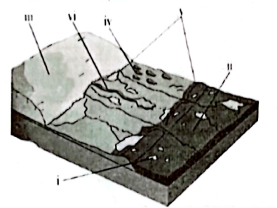
3.The molten material called magma can solidify either inside or outside of the earth's crust. By help of diagrams describe any three intrusive volcanic features associated with cooling of magma.
4.Maua's mother used to cultivate many crops in small area using local seeds and hand hoe and now she is blaming that she harvests nothing in three years and she is complaining that her neighbors are the one who cause that problem. Explain to her five ways on how she can improve her farming system instead of complaining to her neighbors.
5. Form Three students at Muungano Secondary school were assigned to conduct chain survey around their School farm as they were measuring they observed that the line of traverse was not properly stretched.
- What do you think was the type of errors.
- Mention three sources of those errors and explain them.
- Briefly explain four ways of avoiding errors in chain survey.
6. Zamoyoni was talking with his grandfather who believes that the earth’s shape is flat like a table. By using four evidences describe how Zamoyoni will prove to his grandfather that the earth is spherical.
7. You have met with your friend who doesn’t believe on potential use of Geological time scale. By the use of three points, convince him/her to understand its potential.
8. (a) Most of geographers have various perspectives toward classification of rocks, as a form three student who studied geomorphologic process, through the use of diagram classify types of rock according to the mode of formation.
(b) Explain how rocks are important for both social and economic development in our country. Give only five points
SECTION C [30 marks]
Answer only two (2) questions from this section.
9.Mwajuma and Rose are form three students who prefer to study about mass wasting that said to be the movement of weathered materials down the slope due to the gravitational force. As a form three student who studies mass wasting, use examples to explain five(5) factors affecting the rate of mass wasting.
10.Jane’s grandfather believes that studying geography in the current globalized world is just a wastage of time since each and every thing can be accessed through social network, television and internets. As a geography student assist Jane’s grandfather by proving that studying geography is significance in our daily life. Give five (5) points.
11. Jovan was inside the house when he observed a house shaking due to vibration of Earth's surface caused by natural forces operating beneath the Earth's crust. With examples, explain five effects of that hazard.
FORM THREE GEOGRAPHY EXAM SERIES 259
FORM THREE GEOGRAPHY EXAM SERIES 259
PRESIDENT'S OFFICE REGIONAL ADMINISTRATION AND LOCAL GOVERNMENT
FORM THREE ANNUAL EXAMINATION
013 GEOGRAPHY
TIME: 3:00 Hours November, 2025
INSTRUCTIONS
- This paper consists of sections A, B and C with a total of eleven (11) questions.
- Answer all questions in section A, B and two (2) questions from section C.
- Section A carries sixteen (16) marks, section B fifty-four (54) marks and section C thirty (30) Marks.
- Map extract of LIWALE sheet 280/4 is provided.
- All working must be in blue or black ink, except for diagrams that must be drawn in pencil.
- All communication devices, and any unauthorized materials are not allowed in the examination room.
- Write your name on every page of your answer sheet (s)
SECTION A (16 Marks)
Answer all questions in this section
1. For each of the item (i) – (x), choose the correct answer from among the given alternatives and write its letter in the answer sheet (s) provided
(i) All the following are famous tourist attraction sites in Tanzania except;
- Mikumi wildlife, Tarangire and Ruaha reserve.
- Serengeti national park, Mount Kilimanjaro and Mikumi
- Selous reserve, Tarangire and Mikumi Park
- Tsavo, Turkana and Oldonyo Lengai
- Tarangire, Ruaha reserve and Serengeti national park
(ii) SIMA and SIAL are separated by the zone called;
- Sialic
- Mohorovic discontinuity
- Mesosphere
- Conrad discontinuity
- Gutenberg discontinuity
(iii) Chemical weathering is most dominant in areas of;
- High temperature and high humidity
- Low temperature and low humidity
- High temperature and low humidity
- Low temperature and high Humidity
- Only high temperature
(iv) The prediction of the state of atmosphere in a region for 24 to 48 hours is known as;
- Weather elements
- Weather report
- Weather instruments
- Weather station
- Weather forecasting
(iv) The temperature of Dodoma at 1200 meters above the sea level is 20℃. What will be the temperature of Mbeya at 2000 meters above sea level?
- 16℃
- 18℃
- 15.2℃
- 14.8℃
- 30.4℃
(v) A channel diverging from the main river and flowing into the sea or lake by a separate mouth is known as;
- Watershed
- Distributary
- Tributary
- Ox – bow lake,
- A stream
(vi) Suppose the local time at Greenwich meridian is 12:00 noon, what is the local time at Msepe which is 10°S 40°E?
- 12:20 AM
- 2:00PM
- 2:20 PM
- 2:40 PM
- 2:40 AM
(vii) Suppose you are living in urban center and you are interested in keeping livestock. What type of livestock keeping would be suitable for you?
- Nomadism
- Ranching
- Transhumance
- Pastoralism
- Sedentary
(viii) If the location of a point on a map is given by grid reference 365490, then;
- 490 are northings
- 490 are Eastings
- 365 are degrees
- 365 are northings
- 365 are longitudes
(x) Soil is among factors which determines economic activities together with;
- Climate
- Type of zone
- Nature of people
- Agricultural activities
- Equatorial zones
2. Match the descriptions of River rejuvenation features in Column A with the corresponding features in Column B by writing the letter of the correct response beside the item number in the answer sheet (s) or booklet(s) provided.
| COLUMN A | COLUMN B |
|
|
|

SECTION B (54 MARKS)
Answer all questions in this section.
3. Carefully Study the map extracts of Liwale sheet 280/4 provided, then answer the questions that follow
- With supporting evidence from the map, describe settlement pattern of the mapped area.
- By giving the evidence from the map, name four socio-economic activities carried out in the area
- Calculate the area covered by forest using square method. Give your answer in Km2.
- Change the scale of the map into a statement scale
- By giving evidence from the map, describe two main types of transport found in the mapped area.
4. Study the table below showing production of coffee in Tanzania in“000”tons 1990 to 1996.
| Year | 1990 | 1991 | 1992 | 1993 | 1994 | 1995 | 1996 |
| Coffee | 400 | 250 | 200 | 100 | 150 | 80 | 80 |
- Construct a divergent line graph to represent the data above
- Give an alternative method that can be used to show the above data.
- What are the two merits and two demerits of the method used?
5. Carefully study the following statistical data and then answer the questions that follow;
a. What do you understand by the following statistical terms?
- Mode
- Median
- Mean
(b) What are the uses of statistical graphs and diagrams? Give four (4) points.
6. (a) After learning different types of simple land survey students were asked to explain fruits of studying chain survey but only Yoweri failed to explain. Assume you are a student who understood the lesson, how will you help him to explain fruits of chain survey? (Any five points)
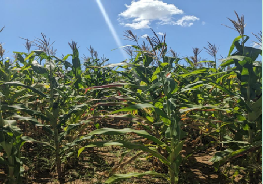
7. Study the following photograph below then answer the questions that follow:

- With two reasons, name the type of photograph shown above
- State the title of the photograph
- Mention four famous regions in Tanzania where this crop is grown
- Mention two condition necessary for the growth of crop you have mentioned in (a) above e. State the scale of photograph
- With evidence show two contribution of crop shown to the economy of Tanzania
8. Juma and Baraka conduct a dialogue about the shape of the earth, Juma said that ‘the shape of the earth is flatted sphere’ but Baraka argue that ‘the shape of the earth is spherical’ with six (6) points, justify the Juma’s argument
SECTION C (30 MARKS)
Answer two (2) questions from this section
9. Construction of Nyerere dam helps Tanzanians to earn advantageous than disadvantageous, as a student who studied regional focal studies in form two what you think Tanzanians will enjoy for that project.
10. Plantation is the most common form of agriculture practiced in tropical region of Africa, Asia and South America. Justify six (6) characteristics of plantation agriculture practiced these areas.
11. The Minister of national resources and Tourism in Tanzania has been so much active in promoting tourism sector. “Despite the economic significance of the sector, there are negative impacts to our country”. Elaborate this statement by giving six (6) points.
FORM THREE GEOGRAPHY EXAM SERIES 247
FORM THREE GEOGRAPHY EXAM SERIES 247
THE UNITED REPUBLIC OF TANZANIA PRESIDENT’S OFFICE – REGIONAL ADMINISTRATION AND LOCAL GOVERNMENT
FORM THREE ANNUAL EXAMINATION – 2025
GEOGRAPHY
TIME: 3 HOURS
INSTRUCTIONS
- This paper consists of three sections A, B and C.
- Answer all questions in sections A and B and two (2) questions from section C.
- Cellular phones and unauthorized materials are not allowed in the examination room.
- Write your answers in the spaces provided.
- All drawings should be neat and well-labeled.
SECTION A (16 Marks)
Answer all questions in this section.
1. Multiple Choice Questions (10 marks)
- Choose the correct answer from the given alternatives and write its letter in the answer booklet.
(i) Which of the following instruments is used to measure wind direction?
- Thermometer
- Anemometer
- Wind vane
- Barometer
(ii) Rift valleys are mainly formed due to:
- Erosional activities
- Compressional forces
- Tensional forces
- Denudation
(iii) Which type of climate is characterized by rainfall throughout the year and high humidity?
- Mediterranean climate
- Equatorial climate
- Desert climate
- Tundra climate
(iv) Which of the following is a secondary source of geographic information?
- Aerial photographs
- Topographic maps
- Field observation
- Textbooks
(v) The line that joins all places of equal rainfall on a map is called:
- Contour
- Isobar
- Isohyet
- Isotherm
(vi) Which of the following minerals is non-metallic?
- Gold
- Iron
- Limestone
- Copper
(vii) The process through which sand and pebbles grind against the riverbed and banks is known as:
- Attrition
- Abrasion
- Solution
- Hydraulic action
(viii) Which one of the following is a human factor influencing population distribution?
- Fertility of soils
- Climate
- Political stability
- Relief
(ix) The boundary between the Earth’s crust and the mantle is called:
- Asthenosphere
- MohoroviÄić discontinuity
- Core-mantle boundary
- Lithosphere
(x) Which of the following renewable energy sources is mostly developed in Tanzania?
- Wind power
- Solar power
- Hydroelectric power
- Geothermal power
2. Matching Items (6 marks)
Match the descriptions in List A with the correct terms in List B by writing the letter of the correct response. Each choice may be used once only.
| LIST A | LIST B |
| (i) The angular distance north or south of the equator. (ii) A map that shows natural and man-made features of an area. (iii) The process of determining the relative height of points on the earth's surface. (iv) The ratio between the distance on a map and the corresponding distance on the ground. (v) A drawing representing the earth's surface on a flat sheet. (vi) The point where latitude is measured from. |
|
SECTION B (54 Marks)
Answer all questions in this section. Each question carries 9 marks .
3. Carefully study the map extract of Kigoma sheet (92/3) and answer the questions that follow
(a) Calculate the length of Uvinza road in kilometers from grid reference 020635 to grid reference 950648
(b) Describe with evidence two methods used to show relief features from the map
(c) Citing evidence from the map, suggest three economic activities and two social activities that are taking place on the mapped area
(d) With evidence from the map describe any three functions of Kigoma town
(e) With evidence outline three types of settlement patterns from the map
(f) State three factors that might affect the content of a topographical map given.
4. Survey
During a school fieldwork exercise, students were assigned to carry out a chain survey around the school compound. (a) Explain three reasons why chain survey is suitable for such a task.
(b) Mention two challenges the students might encounter while using the chain survey method. (c) Describe two precautions to be taken when booking field data.
5. Photography
Study the photograph below and answer questions that follows;
 |
(a) Differentiate between ground photographs and aerial photographs. (b) Suggest three human activities taking place in the area shown. (c) Explain two advantages of using photographs in geographical studies.
6. Statistics
The table below shows the production of maize in a certain district (in tonnes) from 2020 to 2024.
| Year | 2020 | 2021 | 2022 | 2023 | 2024 |
| Maize Production | 450 | 500 | 600 | 550 | 700 |
(a) Draw a simple line graph to represent the data.
(b) Describe the trend of maize production from 2020 to 2024. (c) State two advantages of presenting data using graphs.
7. Forces Affecting the Earth
(a) Distinguish between endogenic and exogenic forces.
(b) With examples, explain two effects of volcanic activities on human environment. (c) Describe one advantage and one disadvantage of earthquakes.
8. Structure of the Earth
(a) Outline three characteristics of the earth’s core. (b) Explain two roles of the atmosphere in supporting life. (c) Suggest two ways in which the biosphere interacts with the lithosphere.
SECTION C (30 Marks)
Answer two (2) questions from this section. Each question carries 15 marks .
9. Sustainable Mining Activities
Mining is one of the major economic activities in Tanzania but has led to several environmental problems. With reference to specific examples, discuss six sustainable mining practices that can promote both economic development and environmental conservation.
10. Sustainable Forestry
Deforestation is a serious environmental challenge in many parts of Africa. Using case studies from Tanzania , analyze the causes of deforestation and propose five strategies for promoting sustainable forestry .
11. Sustainable Use of Power and Energy Sources
Energy is vital for economic development, but unsustainable use of power sources contributes to global warming. With relevant examples, evaluate the importance of sustainable use of power and energy resources in Tanzania and suggest five measures to ensure their sustainability.
FORM THREE GEOGRAPHY EXAM SERIES 236
FORM THREE GEOGRAPHY EXAM SERIES 236


FORM THREE GEOGRAPHY EXAM SERIES 210
FORM THREE GEOGRAPHY EXAM SERIES 210
FORM THREE GEOGRAPHY EXAM SERIES 209
FORM THREE GEOGRAPHY EXAM SERIES 209
THE OFFICE OF THE PRESIDENT, REGIONAL ADMINISTRATION AND LOCAL GOVERNMENT.
SECONDARY EXAMINATION SERIES
MARCH 2025
GEOGRAPHY FORM THREE
TIME: 2:30HRS
INSTRUCTIONS
- This paper consists of three(3) sections A, B and C with a total of ten (10) questions
- Section A carries fifteen (15) marks, section B seventy (70) marks and section C fifteen (15) marks.
- Answer ALL questions in all sections
- Write your names and stream on the top center in every page of your examination
- ALL answers should appear in this question paper in the space provided.
SECTION A
1. For each of the items (i)-(x) choose the correct answer from among the given alternative and write its letter besides the item number in the answer booklet provided. (@1mark=10 marks)
(iii) Tanzania is expecting to benefit a lot from the current Standard Gauge Railway (SGR) project. The following are some of the importance of this project except;
- A It will cause civil war
- B It will improve trade relations with neighboring countries.
- It will create employment opportunities
- It will encourage industrial development
- It will save time for transportation.
(iv) If you are living in urban center and you are interested in keeping livestock. What type of livestock keeping would be suitable for you?
- Nomadism
- Ranching
- Transhumance
- Pastoralism
- Sedentary
(v) Form four students at Pengo village (75°W, 78° N) were watching the football on TV at 7.30 pm on Tuesday. At what time and day people in Keira village (45° E, 06° S) will be watching the same match?
- 3:30 am Wednesday
- 12:30 pm Tuesday
- 11:30 am Wednesday
- 3:30 pm Wednesday
- 09:30 am Tuesday
i. The solar system is made-up of the sun, planet and other heavenly bodies which revolve around the sun, which planet has the shortest orbit?
- Pluto
- Mercury
- Mars
- Earth
- Venus
(ii) Suppose you want to carry out a field study on factors which used to classify the climate of a place, what are the best components of weather you are going to consider?
- Temperature and rainfall
- Temperature and cloud cover
- Rainfall and sunshine
- Cloud cover and humidity
- Sunshine and humidity
(iii) The tourist reported enjoying the temperature of Ihefu wetland in Mbeya at 1500 meters above sea level, which is 32C. They also planned to travel from Ihefu to Unguja in Zanzibar which is at sea level. What might be the temperature experienced by the tourist in Zanzibar?
- 23°C
- 0.6 °C
- 9 °C
- 41 °C
- 19 °C
(iv)The name given to a boundary that demarcates solid materials from the molten mantle is known as:
- Asthenosphere
- Gutenberg
- Mohorovic
- Mesosphere
- Core
(v) All the following are famous tourist attraction sites in Tanzania except?
- Mikumi wildlife, Tarangire and Ruaha
- Serengeti national park, Mount Kilimanjaro and Mikumi
- Selous reserve, Tarangire and Mikumi Park
- Tsaro, Turkana and Oldonyo Lengai
- Tarangire, Ruaha reserve and Serengeti national park
(vi) Dormant volcanic mountains are those which:
- Have never experience eruption
- Have erupted once but are no longer active
- Continue to erupt occasionally
- Erupt only when there is an earthquake
- Erupt every
ix. The people of Utengule Village are served by electricity from TANESCO and sometimes they use energy that they produce from Organic materials after being broken down by bacteria in an oxygen free environment. What is the name of such energy source?
- Hydroelectric power
- Biogas
- Solar energy
- Wind energy
- Solar energy
2. Match the items in List A with response in List B by writing the letter of the correct response below the corresponding item number in the table provided.
| List A | List B |
|
|
SECTION B. 70 MARKS
3. (a) Classify three pollutants from manufacturing industries.
(b) Explain three effects of these pollutants to the people and environment.
4. (a) Convert the following scales according to the instructions given
- “One centimeter on the map represents two and half a kilometer on the ground”. Convert this scale into Representative fraction (R.F.) scale.
- 1:100000. Convert into statement scale.
- 1:50000. Convert into statement scale.
(b) State the compass direction for each of the following compass bearings.
- 280º ..
- 135º ..
- 45º ....
(c) How can the positions of objects be shown in any topographical map? Mention four(4) points.
5. Define the following terminologies:
(a) Bush following
. . . . . . . . . . . . . . . . . . . . . . . . . . . . . . . ....
. . . . . . . . . . . . . . . . . . . . . . . . . . . . . . . . . . . . . .
(B)Land reclamation
. . . . . . . . . . . . . . . . . . . . . . . . . . . . . . . . . . . . . . .
. . . . . . . . . . . . . . . . . . . . . . . . . . . . . . . . . . . . . .
. . . . . . . . . . . . . . . . . . . . . . . . . . . . . . . . . . . . . .
(c)Hydrological cycle . . . . . . . . . . . . . . . . . . . . . . . . . . . ..
. . . . . . . . . . . . . . . . . . . . . . . . . . . . . . . . . . . . . .
. . . . . . . . . . . . . . . . . . . . . . . . . . . . . . . . . . ...
. . . . . . . . . . . . . . . . . . . . . . . . . . . . . . . . . . . . . .
(d)Water pollution . . . . . . . . . . . . . . . . . . . . . . . . . . . . .
. . . . . . . . . . . . . . . . . . . . . . . . . . . . . . . .. . . . . .
(e)Tourism . . . . . . . . . . . . . . . . . . . . . . . . . . . . . . . .
. . . . . . . . . . . . . . . . . . . . . . . . . . . . . . . . . . . . . .
6. (a) Point out five ways to which Tanzanians benefits from solar energy.
i. ____________________________________________________________________
ii. _______________________________________________________________________
iii. ________________________________________________________________________
iv. ________________________________________________________________________
(b) In which ways the Tanzania society benefits from weather forecasting?
Give five points
i. ____________________________________________________________________
ii. _____________________________________________________________________
iii. _____________________________________________________________________
iv. _____________________________________________________________________
v. _____________________________________________________________________
7. John, a form two student from Mgudeni Secondary School was unable to differentiate some geographical terms; he decided to seek advice from his fellow students. As among of form two students, help John him to differentiate the following geographical terms,![]()
i) Plains and plateaus
ii) Umbra and penumbra
iii) Secondary and tertiary activities
iv) Natural forest and artificial forest
v) Solar energy and solar system
8. Mr. Kasheko was watching the video program showing the ejection of molten materials with in the earth`s crust or onto the earth `s exterior. This process accompanied with the outbreak of ashes,gases and smokes. This molten materials sometimes cool solidify within the earth’s crust to form both hypabyssal and plutonic rocks. And sometimes other materials reach the surface to form volcanoes.
- What is the genetic process observed by Mr. Kasheko from the video program?
- With examples explain the types of features produced by the process named in (a) above?
- Outline five (5) environmental impact resulted from the process in (a) above.
- 8. (a) What is a river capture?
- (b) With a well labeled diagram, show features formed in (a) above.
9. (a) What is a river capture?
(b) With a well labeled diagram, show features formed in (a) above.
10.(a) Planet Earth is composed of different land masses known as continents from which we can get different relief features . Mention at least five (5) of them.
(b) All land masses are surrounded by large body of salt water as Oceans.Mention five of them.
SECTION C. 15 MARKS
11. With reference to Rufiji River Basin Project and TVA, explain how community surrounding these project can benefit from them. (Six points)
FORM THREE GEOGRAPHY EXAM SERIES 199
FORM THREE GEOGRAPHY EXAM SERIES 199
THE PRESIDENT’S OFFICE
REGIONAL ADMINISTRATION AND LOCAL GOVERNMENT
FORM THREE ANNUAL EXAMINATION
GEOGRAPHY
TIME: 3 HOURS NOVEMBER 2024
Instructions
1. This paper consists of three sections A, B and C with a total of eleven (11) questions.
2. Answer all questions in sections A and B and two (2) questions from section C.
3. Section A carries sixteen (16) marks, section B carries fifty-four (54) marks and section C carries thirty (30) marks.
4. Map extract of LIWALE (Sheet 280/4) is provided.
5. Cellular phones and any unauthorized materials are not allowed in the examination room.
6. All writings should be in blue or black ink while drawings should be in pencil.
7. Write your Examination Number on every page of your answer booklet(s)
SECTION A (16 MARKS)
Answer all questions in this sections
1. For each of the item (i)-(x); choose the correct answer from the among the given alternatives and write its letter in the box provided
(i) Why does the sun appear larger than other stars that are seen at night?
A. The capacity of our eyes does not view far during the night
B. Starlight bends as it passes planets
C. The earth’s atmosphere filters out light from other stars
D. Day light brightens the sun making it appear larger
E. The sun is closer to the earth than other stars
(ii) If the temperature of Dar es Salaam at 100m above the sea level is 30oC, identify the temperature of Moshi at 3200m above the sea level.
A. 30oC
B. 29oC
C. 10.8oC
D. 11.4oC
E. 19.2oC
(iii) Ngotho and Kamau observed the rain water which penetrate in the ground during the rain season. Which term describes that process?
A. Evaporation
B. Evapotranspiration
C. Infiltration
D. Condensation
E. Precipitation
(iv) Form six students at Maliangumu Secondary School were taught that the Southern Tourist circuit or centre in Tanzania promotes ecotourism. Which of the following is not encouraged in the promotion of ecotourism in the area?
A. Discouraging forest fire
B. Environmental conservation
C. Afforestation
D. Coastal attraction
E. Protecting endangered species
(v) Msemo is working in soaps and toothpastes manufacturing industry as a machine operator. In which type of industry does he work among the following?
A. Food processing industry
B. Metallurgical industry
C. Chemical industry
D. Craft industry
E. Beverage industry
(vi) Tourists from Katoro Kagera visited Amboni Cave. They were excited to see mass of limestone deposits that hang from the roof of the cave. Which features did they see?
A. Stalagmites
B. Stalactites
C. Polje
D. Natural pillar
E. Uvala
(vii) When agricultural officer visited in our farm said that “This soil has high ability to support plant growth and produce high yield.” Which term relates with that statement?
A. Soil pH
B. Soil porosity
C. Soil fertility
D. Soil shape
E. Soil water
(viii) My uncle travelled from Dar es Salaam to Mtwara by using “Buti la Zungu” luxury bus. Which element of weather can easily affect that means of transport?
A. Wind
B. Humidity
C. Precipitation
D. Temperature
E. Pressure
(ix) “The deadly Mudslide claimed 65 lives and left 115 others injured in Hanang.” Daily news reported. Which term describes that event?
A. Weathering
B. Earthquake
C. Floods
D. Mass wasting
E. Volcanic eruption
(x) Despite its importance, airport activities are contributing to the environmental pollution. Which type of pollution it generates?
A. Soil and water pollution
B. Air and soil pollution
C. Noise and air pollution
D. Radiation and noise pollution
E. Air and radiation pollution
2. Match the description of features formed by wind erosion in Column A with corresponding features in column B by writing the letter of correct answer beside item number in answer booklet provided.
| Column A | Column B |
|
|
|
SECTION B (54 Marks)
Answer all questions in this section
3. Carefully study the extract map of Liwale sheet 280/4 then answer the following questions:
(a) Find the area covered by forest in km2 north of 200.
(b) With evidences from mapped area, state the direction of river Liwale.
(c) Describe two (2) methods used to show the relief on the mapped area.
(d) With two (2) reasons to what extent settlement and transport affect vegetation of the mapped area?
4. Olabisi constructed a pie chart showing a favourite soft drinks used by 72 customers on her shop. The angles of the pie chart used are given below:
| Soft drinks | Coca Cola | Pepsi Cola | Fanta | Mirinda | 7-up |
| Angles | 100o | 90o | 60o | 40o | 70o |
(a) Calculate actual number of customers who liked soft drinks shown on the table above.
(b) Use the simplest method by means of bar to show the actual value of the soft drinks liked by customers obtained in (a) above.
(c) Describe two (2) demerits of the method used by Olabisi to show the favourite soft drinks.
5. The Municipal survey team in Tanga City is expecting to measure the length of the street roads that have been affected by heavy rainfall for improvement.
(a) What is the first step to be carried out before actual measurements?
(b) Why that step is important? (Two (2) points)
(c) Apart from measuring devices, point out five (5) equipment with their uses.
6. The villagers from Oldonyo Lengai observed an eruption of molten rocks (magma/lava) that flows outside the earth’s crust. After sometime the molten rock cooled and solidified.
(a) Name the type of rocks found in that village.
(b) Describe three (3) characteristics of the rocks named in (a) above.
(c) Highlight three (3) economic importance of the rocks found in that area.
7. Carefully study the following photograph and answer the questions that follow:
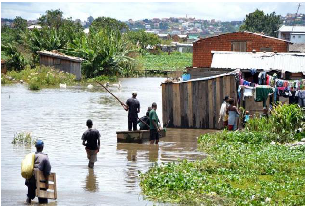
(a) With one reason identify the type of photograph.
(b) Give the name of the phenomenon which has taken place in the photograph.
(c) With two (2) points explain how urbanization influences the above phenomenon.
(d) Describe two (2) possible solutions would be taken to overcome that problem.
8. Form three students visited the river mouth of Rufiji River and they found the river pours in water into the Indian ocean by spreading many small channels called distributaries covering a wide flat land with alluvium deposit forming a triangular shaped feature
(a) Identify feature observed by form three students
(b) Describe four (4) condition necessary for the formation of a feature named above in (a) above
(c) Briefly explain four importance of a feature in (a) above
SECTION C (30 Marks)
Answer only two (2) questions in this section
9. Despite the challenges the mining sector faces, it has advantages to our economy. With six (6) points support the statement.
10. Form four students of Maji ya Chai secondary school visited three different places and identified different types of soil with variation of physical and chemical properties. Explain six(6) Physical properties of soil they observed.
11. Propose ways of conserving and preserving natural forest for sustainable development
FORM THREE GEOGRAPHY EXAM SERIES 185
FORM THREE GEOGRAPHY EXAM SERIES 185
OFISI YA RAIS, TAWALA ZA MIKOA
NA SERIKALI ZA MITAA
JAMUHURI YA MUUNGANO YA TANZANIA
MTIHANI WA NUSU MUHULA
KIDATO CHA TATU
KISWAHILI 2024-AUG/SEPT
- Maelekezo
- 1. Karatasi hii ina sehemu A, B na C zenye jumla ya maswali kumi (10).
- 2. Jibu maswali yote kwenye nafasi ulizopewa.
- 3. Sehemu A na C zina alama kumi na tano (15) kila moja na sehemu B ina alama sabini (70).
- 4. Zingatia maelekezo ya kila sehemu na ya kila swali.
- 5. Majibu yote yaandikwe kwa kalamu yenye wino wa bluu au mweusi.
- 6. Vifaa vyote vya mawasiliano visivyoruhusiwa havitakiwi katika chumba cha upimaji.
- 7. Andika Namba yako ya Upimaji katika kila ukurasa sehemu ya juu upande wa kulia.
SEHEHU A
Jibu maswali yote katika sehemu hii.
1. Chagua Chagua herufi ya jibu sahihi katika vipengele (i) hadi (x), kisha andika herufi ya jibu hilo kwenye kijitabu chako cha kujibia.
(i) Sentensi ipi kati ya hizi zifuatazo HAINA maana Zaidi ya moja?
- Kaka amefua nguo
- Nipe sahani ya kulia
- Suedi amenunua mbuzi
- Eva amenunua kanga
- Joni amempigia mpira
(ii) Kiimbo hutafsiriwaje katika mazungumzo?
- Kupanda na kushuka kwa mawimbi ya sauti
- Kuzungumza na kuongea kwa sauti
- Kuzungumza kwa kupandisha mawimbi ya sauti
- Kuzungumza kwa kushusha mawimbi ya sauti
- Kuzungumza na kushuka kwa mawimbi ya sauti
(iii) Mkisi ameenda Dodoma. Neno Dodoma limetumika kama aina gani ya neno?
- Kielezi
- Nomino
- Kivumishi
- Kiwakilishi
- kihisishi
(iv) “Changa bia” nahau hii katika lugha ya Kiswahili ina maana ipi?
- Kuepuka matatizo kwa ujanja
- Fika mwisho
- Kula kwa ushirika
- Chombo kipo hatarini
- Kumaliza kikao
(v) Mawazo makuu ya mtunzi wa kazi za fasihi humfikia mlengwa kwa njia ipi kati ya hizi zifuatazo?
- Fani
- Maudhui
- Dhamira
- Falsafa
- Migogoro
(vi) Ipi ni tofauti ya msingi kati ya mashairi na ngonjera?
- Mpangilio wa vina na mizani
- Idadi ya mizani na mishororo
- Majibizano baina ya watu wawili au Zaidi
- Mpangilio maalumu wa silabi na lugha ya mkato
- Mapigo ya kimuziki na ridhimu
(vii) Jambo gani muhimu huzingatiwa na mtunzi wa insha ya hoja?
- Lugha yenye ukinzani
- Lugha ya kisanaa
- Lugha isiyo na mvuto
- Lugha ya kufikirisha
- Lugha inayosifia
(viii) Uwasilishaji wa kazi za fasihi unatofautiana kati ya mtunzi mmoja na mwingine huitwaje?
- Muundo
- Mtindo
- Maudhui
- Falsafa
- Fani
(ix) Unyambulishaji katika lugha ya Kiswahili huhusisha upachikaji wa viambishi___
- Kabla ya mzizi
- Katikati ya mzizi
- Baada ya mzizi
- Kabla na baada ya mzizi
- Kabla, katikati na baada ya mzizi
(x) Ili kuepuka utata katika tungo, ni muhimu
- Kuepuka matumizi ya maneno yenye maana Zaidi ya moja
- Kutumia nahau
- Kutumia aina zote za maneno katika tungo
- Kutumia alama za uandishi
- Kutumia mofu ya kauli ya kutendea
2. Oanisha dhana za nyimbo zilizopo katika ORODHA A na aina ya nyimbo katika ORODHA B Kisha andika herufi ya jibu sahihi katika kijedwali hapo chini.
| ORODHA A | ORODHA B |
|
|
SEHEMU B.
Jibu maswali yote katika sehemu hii.
3. (a) Eleza dhima za mofimu “li” kama ilivyotumika katika sentensi zifuaatazo:-
- Shamba letu li kubwa sana.
- Walichelewa kurudi.
- Tunalifuatilia
- Limeharibika
- Shikilia
(b) Andika sentensi zifuatazo katika hali ya ukanushi.
- Ameshiba sana
- Watoto wengi wanaogelea
- Mvua ilinyesha kwa wingi sana
- Kijana anakula chakula kingi sana
4. (a) Utata katika mawasiliano husababishwa na mambo mengi.Taja sababu Tano (5) zinazosababisha Utata katika lugha.
(b) "Tabibu mzuri ni yule anayejua njia za kutibu ugonjwa"ukitumia msemo huu onesha njia nne (4) zinazoweza kuondoa Utata katika lugha.
5. "Mwalimu wa kidato Cha nne aliwaambia wanafunzi wake waunde maneno mapya."Bainisha njia Tisa (9) walizozitumia kuunda maneno hayo na Kwa Kila njia toa mfano mmoja.
6. Malimusi na Wasakatonge walikuwa wanajadili kuhusu tenzi na mashairi , Malimusi anasema tenzi na mashairi zote ni tungo za kishairi hivyo zinafanana lakini Wasakatonge alikinzana na Malimusi kwa hoja kuntu. Jadili upande wa Wasakatonge kwa hoja sita (6) huku ukitolea mifano hoja zako.
7. Asasi mbalimbali zilizoanzishwa kabla na baada ya Uhuru,mfano UKUTA (1959) na TATAKI(2009) Kwa lengo la kukuza na kuendeleza kiswahili.Onesha changamoto SITA sinazozikumba asasi hizo katika ukuzaji wa kiswahili.
8. Soma kifungu cha habari kisha jibu maswali yafuatayo.
Ndugu wazazi,kumbe safari yenu inahusu harusi ya Zaituni? Mkuu wa shule aliwauliza wazazi “ndiyo” wazazi walijibu kwa Pamoja bila aibu. “inategemewa kufungwa lini”? mkuu aliendelea kuhoji. Harusi hii ilikuwa ifanyike wakati zaituni anapofika kidato cha nne,lakini zainabu huyu ametufanyia uhuni na vituko visivyoelezeka . nasi sasa tunachukiwa na Kijiji kizima na kudharauliwa na kila mtu.
Hii imetuudhi sana, tumetungiwa nyimbo na kufanyiwa kila shutuma. Hatuna raha; hivyo tumeonelea bora tuje kukuomba umfukuze shule ili kiburi kimwishe.
Nasi tupo tayari kukulipa kiasi chochote cha fedha ukitimiza haja yetu hii, “mzee Abdallah alieleza”. Muda wote mkuu wa shule alikuwa akimtazama mzee kwa chata sana.Kisha akauliza swali la kuchochea Zaidi, “zaituni ana kiburi kumbe”
Mama Zaituni hakutaka hilo limpite himahima akatoa maelezo yake. “Mama wewe, zaituni usimuone hivi”. Zaituni mwanangu hataki kufuata utamaduni wetu wa kuolewa. Zaituni ati achague mchumba mwenyewe, ati mahari haioni kama ni kitu cha msingi. Kiburi hicho kinatokana na elimu mliyompa. Mtoto sasa ameharibika. Anafanya apendavyo, elimu gani isiyojali adabu, wala utii?” mama zaituni alimaliza huku jasho na machozi yanamtoka.
Hapa mkuu wa shule aliona kwanza awaelimishe kabla hajawatolea kauli ya mwisho. Alikwishatambua kwamba wazazi wa zaituni walikuwa wameachwa nyuma na wakati. Kila upya wa mawazo waliuita kiburi.
MASWALI
- Wazazi wa Zaituni walikwenda shuleni kufanya nini?
- Wazazi walisema kuwa Zaituni amefanya kosa gani?
- Eleza mgogoro mkuu uliopo kati ya Zaituni na wazazi wake.
- Fupisha Habari hiyo kwa maneno yasiyopungua hamsini( 50) na yasiyozidi sitini(60).
SEHEMU C.
Jibu maswali mawili (2) kutoka katika sehemu hii, Swali la kumi ni lalazima.
ORODHA YA VITABU
USHAIRI
- Wasatonge – M. S Khatibu (DUP)
- Malenga wapya - TAKILUKI (DUP)
- Mashairi ya chekacheka - T. A. Mvungi (EP& D. LTD)
RIWAYA
- Takadini - Ben. J. Hanson (MBS)
- WAtoto wa mama N’tilie - E. Mbogo(H.P)
- Joka la mdimu - A. J. Safari (H.P)
TAMTHILIYA
- Orodha - Steve Reynolds (M)
- Ngoswe penzi kitovu cha uzembe - E. Semzaba(ESC)
- Kilio Chetu - Medical Aid Foundation (TPH)
9. Msanii yeyote wa kazi ya fasihi anafananishwa na mwavuli kwa jamii yake, kwa kuwa anatumia macho yake kuona maovu yaliyomo katika jamii na hutumia kalamu yake kuishauri na kuikinga jamii yake isipatwe na mabaya. Thibitisha kauli hii kwa kudadavua maovu yaliyoibuliwa na waandishi wa riwaya mbili ulizosoma. Hoja tatu kwa kila riwaya.
10. Waandishi wengi wa fasihi hupenda kutumia jazanda mbalimbali katika kuelimisha jamii katika maswala kadha wa kadha.Hivyo tumia jazanda mbalimbali kutoka diwani mbili ulizosoma kuonesha walivyosaidia kuelimisha jamii.Toa hoja tati(3)wa Kila kitabu.
11. "Uibushaji WA migongano katika tamthiliya ni nyenzo muhimu katika ufanikishaji wa tamthiliya "Kwa kutumia vitabu viwili(2)kati yavile ulivyosoma,Jadili kauli hii Kwa kutoka hoja tati (3) Kwa Kila kitabu.
FORM THREE GEOGRAPHY EXAM SERIES 181
FORM THREE GEOGRAPHY EXAM SERIES 181
THE PRESIDENT’S OFFICE
REGIONAL ADMINISTRATION AND LOCAL GOVERNMENT
SECONDARY EXAMINATION SERIES
MID TERM ONE EXAMINATION, AUG/SEPT -2024
FORM THREE
GEOGRAPHY
INTRUCTIONS TIME:2:30
- This Paper Consist Two Section A & B With A Total Of Twelve (12) Questions.
- Answer All Questions In Section ‘’A ‘’ And Two Question From Section ‘’B’’
- Section “A” Caries Seventy (15) Marks , Section B’’ Thirty (30) Marks.
- Programmable Calculator , Cellular Phones And Any Unauthorized Materials Are Not Allowed In The Examination Room.
- Write Your Name On Every Page Of Your Answer Sheet.
SECTION A (70-MARKS)
ANSWER ALL QUESTIONS FROM THIS SECTION.
i. A city located very close to the Equator is likely to experience:
- Short days and long nights all year
- Very cold winters and hot summers
- Hot temperatures and roughly equal day/night length all year
- Four distinct seasons
ii. Which of the following is not an element of weather?
- Humidity
- Precipitation
- Sunshine
- Climate
iii. Mountains which are formed by the process of denudation are referred to as:-
- Fold mountains
- Residual mountains
- Block mountains
- Volcanic Moutains
iv. Understanding how different cultures interact with their environment is important because:
- It can help us build maps
- We can learn how people used to live
- It helps us make choices that protect the planet
- It tells us who the best explorers were
v. Which one of the following is not a factor to consider while deciding the climate of a place?
- Prevailing winds
- Annual rainfall
- Distance from the ocean
- Annual range of temperature.
vi. Among the following is the only problem associated with over exploitation of forest resources.
- Desertification
- Low technology
- Poor transport and communication
- Poor capital to be used.
vii. The production of bulk products like iron, steel, car assembly and ship building is referred to as:-
- Heavy industry
- Simple or light industry
- Secondary industry
- Primary industry
viii. Solar energy coming from the sun is referred to as:-
- Renewable energy resource
- Non – renewable energy resource
- Tidal power source
- Hydroelectric power.
ix. Water transport is also referred to as:-
- Marine transport
- Sea transport
- River transport
- Lake transport
x. Total volume of pores or empty spaces between soil particles is termed as;
- Soil texture
- Soil porosity
- Soil structure
- Soil profile
2. Match the items from LIST A with the correct response in LIST B by writing a letter of the correct answer.
| LIST A | LIST B |
|
|
SECTION B
3. Explain how the following factors determine soil formation?
i) Parent rock material
ii) Climate
iii) Living organisms
iv) Relief
v) Topography.
4. (a) What do you understand by:-
- Nominal scale
- Ordinal scale
- Interval scale
- Ration scale
(b) Differentiate parametric and non – parametric data
5. Explain the importance of glacial erosional and depositional features.
6. Explain the differences between mechanical, chemical, and biological weathering, providing examples of each.
7. What are the factors that have influenced the development of car manufacturing industry in Japan?
8. (i) Classify rocks according to mode of formation.
(ii) Identify three minerals that are found in igneous rocks.
9. Carefully study the photograph provided below and then answer the questions that follow
- Name the crop shown in the photograph
- Mention three necessary physical conditions for the growth of the
- With two reasons determine the type of photograph
- Mention two contributions of economic activity taking
10. List the advantages and disadvantages of air transport.
SECTION C-ANSWER QUESTION 11
11. What are the factors that favour the development of Hydro electric power (H.E.P)?
FORM THREE GEOGRAPHY EXAM SERIES 180
FORM THREE GEOGRAPHY EXAM SERIES 180
PRESIDENT’S OFFICE, REGIONAL ADMINISTRATION AND LOCAL GOVERNMENT
SECONDARY EXAMINATION SERIES,
TERMINAL EXAMINATION-MAY
GEOGRAPHY FORM THREE.
Time: 3Hours
Instructions
- This paper consists of sections A, B, and C with a total eleven (11) questions.
- Answer all question in the sections A, B and two (2) questions from section C.
- Section A carries sixteen (16) marks, section B fifty four (54) marks and section C carries thirty (30) marks.
- All writing should be in blue or black pen, except for diagrams that must be drawn in pencil.
- Communication devices and any unauthorized materials are not allowed in the examination room.
- Write your Examination Number on every page of your answer booklet (s
SECTON A (16 MARKS)
- Choose the correct answer from among the alternative given.
i. The prediction of the state of the atmosphere can be done through both modern and traditional methods. Which among the following does not fit among the traditional methods used to predict weather.
- By looking at the position of the moon
- By hearing the voices of frogs
- By practicing female circumcision
- By hearing the voices of birds
- By experiencing the change of wind direction
ii. Form four students at Ngomanight secondary school were making the revision on the concept of land forms formed by vulcanicity. What do you think was the correct classification of volcanic landforms?
- Many parts according to Lava.
- Sills, dykes, valleys and earthquakes only
- Volcanic mountains and sills only
- Extrusive and intrusive features
- Batholiths, dykes and volcano only
v. Form two students at a certain school in Tanzania were taught that tourism can be done by observing minimum negative impact to the environment. Which type of tourism falls into this kind of practice?
- International tourism
- Domestic tourism
- Eco- tourism
- International tourism and domestic tourism
- Economic tourism
vi. During December holiday Caren and Kellyne decided to visit Azam company Limited in Dar es salaam where different products are made.They could see Mangoes being changes into juice and milk into Azam ice-cream. In what type of human activity does the Azam Company Limited activities falls?
- Primary human activities
- Tertiary human activities
- Quinary human activities
- Secondary human activities
- Quaternary human activities
(i) Which among the following layers of the atmosphere is characterized by 16 kilometers -thick at the equator and its temperature decreases with an increase in altitude?
- Troposphere
- Thermosphere
- Stratosphere
- Mesosphere
- Exosphere
(ii) Suppose you are living in urban center and you are interested in keeping livestock. What type of livestock keeping would be suitable for you?
- Nomadism
- Ranching
- Transhumance
- Pastoralism
- Sedentary
(v) Robert is living near the mountain within the time he noticed the bending of truck of trees and fences downward the slope. Identify the type of process occurred
- Land slide
- Mudflow
- Soil creep
- Rock fall
- Soil erosion
(vi) Kadege and Anna were debating on the section of a river characterized by a sharp V-shaped valley and interlocking spurs. As you are familiar with those phenomena, select the correct answer to educate them.
- The old stage
- The middle stage
- The youth stage
- The mature stage
- The young and middle stage
(iii) Manchester United team scored a goal at 5:00 pm in England (150 W). At what at Dar es Salaam (450E) the goal was scored?
- 1:00 pm
- 7:00 pm
- 9:45 pm
- 9:00 pm
- 6:30 am
(iv) Recently in Chile, the land with vegetation was sliding down a slope and people were busy taking photographs and wondering to the situation. Tell them what type of geological process was taking place
- Erosion and deposition
- Denudation and transportation
- Land slide and erosion
- Mass wasting and transportation
- Landslide and deposition
2. Match the description of desert land forms in list A with the corresponding names in list B by writing the letter of the correct response beside the item number in the answer booklet(s)
| LIST A | LIST B |
|
|
SECTION B: 54 MARKS
ANSWER ALL QUESTIONS
3.(a) Differentiate between longitudes and latitudes
(b) Give the importance of longitudes and latitudes
4. Describe the following features found on the ocean floor
- Continental shelf
- Continental islands
- Corals islands
- Ocean trench
- Abyssal hill
5. (a) Explain the relationship between weather and climate
(b) Explain four impacts of climate change on human activities
6. (a) Explain the formation of orographic rainfall
(b) List five factors affecting the climate of a place
7. (a) State and explain three types of rocks according to their mode of formation
(b) Briefly explain economic importance of rocks
8.(a) Using a diagram explain the following features;
- Ash and cider cones
- Shield volcano
- Acid lava cone
(b) Explain four importance of volcanic activities
SECTION B: 30 MARKS
Answer any two questions.
9.(a) Define mass wasting
(b) Explain the factors that affect the speed and nature of mass wasting.
10. Discuss the benefits of Rufiji Basin water Board
11. Describe four positive and four negative impacts of tourism in the world.
FORM THREE GEOGRAPHY EXAM SERIES 170
FORM THREE GEOGRAPHY EXAM SERIES 170
PRESIDENT’S OFFICE, REGIONAL ADMINISTRATION AND LOCAL GOVERNMENT
SECONDARY EXAMINATION SERIES,
MID TERM ONE – MARCH-2024
GEOGRAPHY FORM THREE
Time: 3Hours
Instructions
- This paper consists of sections A, B, and C with a total eleven (11) questions.
- Answer all question in the sections A, B and two (2) questions from section C.
- Section A carries sixteen (16) marks, section B fifty four (54) marks and section C carries thirty (30) marks.
- All writing should be in blue or black pen, except for diagrams that must be drawn in pencil.
- Communication devices and any unauthorized materials are not allowed in the examination room.
- Write your Examination Number on every page of your answer booklet (s)
SECTION A (16 MARKS)
Answer all questions in this section
- For each of the following items (i-x).Choose the best answer among the given alternatives given and writer it’s later beside the item number in answer booklet provided
- What will be happened when the orbit of heavenly body is nearest to the sun.
- Perihelion
- Aphelion
- Sunrise
- Equinox
- Sunset
- Masawe prefer to transfer his car from Japan to Tanzania. Which mode of transport would be best to use
- Water
- Pipeline
- Cable
- Animal
- Road
- Alex prefers to cultivate vegetables, maize and beans in his farm. What type of farming is he practicing
- Mixed farming
- Bush farming
- Large scale farming
- Crop rotation
- Shifting cultivation
- Sometimes people living central Tanzania experience sudden vibration of the earth surface cause by movement of the molten rocks below or within the crust. Identify the instrument to be measure the magnitude of such vibration
- Hygrometer
- Thermometer
- Wind vane
- Richer scale
- Barometer
- It is noon in Addis Ababa (390 E). What will be the time in Dar-Es Salaam which is located along the same longitude
- 12.00pm
- 12:00 am
- 06:00pm
- 11:00 am
- 6:00 am
- The prediction of the state of the atmosphere can be done through both modern and traditional methods. Which among the following does not fit among the Traditional method used to predict weather?
- By looking at the position of the moon
- By hearing the voices of frogs
- By practicing female circumcision
- By hearing the voices of the birds
- By experiencing the change of wind direction
- Form two students at Mwenzi Secondary School were discussing Tourism in Tanzania. The observed that minimum impact to environment form of tourism fails in this category?
- International tourism
- Domestic tourism
- Eco- tourism
- Economic tourism
- International Tourism and domestic tourism
- You are living in Urban centre and you are interested in keeping livestock. What type of livestock keeping wpuld be suitable for you?
- Normadism
- Ranching
- Transhumance
- Pastoralism
- Sedentary
- The rock which do not allow water to pass through them are said to be
- Water table
- Sand stone
- Porous
- Impermeable
- Rock debris
- During dry season, most plants shade their leaves on a way to reduce the amount of water released. The correct term for this process is
- Evaporation
- Precipitation
- Transpiration
- Condensation
- Infiltration
- Match the term on list A with correct phrase in list B by writing the correct letter on table given
| LIST A | LIST B |
|
|
SECTION B
54 MARKS
Answer all questions in this section.
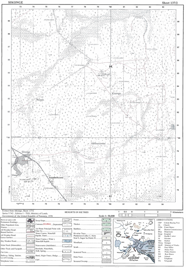
- Study the map extract of SIKONGE ( SHEET 137/2) and answer the following questions
- Using the given RF scale, determine the length of the road in Kilometers from grid reference 740829 to grid reference 760881
- Determine the areas at right hand side of northing 800 in Km2
- With examples name 2 ways used to show height of the land on mapped area
- Under what climate region is the given mapped area found?
- (a)Differentiate between meteorites and asteroids
b) List four domestic uses of solar energy
- Differentiate between the following terms
- Lake and river
- Plains and plateau
- Continental shelf and continental slope
(b) Give three examples of Fold Mountains in the world
- Describe the formation of cyclonic rainfall
- Carefully study the climatic data in table below and answer question that follow
| MONTH | TEMP 0C | RAINFALL (MM) |
| J F M A M J J A S O N D | 9 10 11 2 16 20 23 24 21 18 14 11 | 102 66 84 51 42 18 3 3 31 86 104 112 |
- Calculate the annual range of temperature for the station
- Calculate the mean annual temperature
- Calculate the total annual rainfall
- Draw a climograph to present the data and comment on nature of climate
- Mention four vegetable types found in station
- What are the major economic activities conducted in the stations
- Earth quakes are common phenomenon with examples, explain five effects of earth quakes
SECTION C
30MARKS
Answer two questions from this section
- What are main challenges facing livestock keeping in Tanzania?
- Describe six sources of renewable energy found in Tanzania.
- Outline the challenges facing Natural gas extraction in Tanzania.
FORM THREE GEOGRAPHY EXAM SERIES 162
FORM THREE GEOGRAPHY EXAM SERIES 162
THE PRESIDENT’S OFFICE REGIONAL ADMINISTRATION AND LOCAL GOVERNMENT
SECONDARY EXAMINATION SERIES
ANNUAL EXAMINATION, NOV -2023
FORM THREE GEOGRAPHY
INSTRUCTIONS TIME:2: 30
- This Paper Consist Two Section A & B With A Total Of Twelve (12) Questions.
- Answer All Questions In Section ‘’A ‘’ And Two Question From Section ‘’B’’
- Section “A” Caries Seventy (15) Marks, Section B’’ Thirty (30) Marks.
- Programmable Calculator, Cellular Phones And Any Unauthorized Materials Are Not Allowed In The Examination Room.
- Write Your Name On Every Page Of Your Answer Sheet.
SECTION A (16-MARKS)
1. For each of items (i) – (ix), choose the most correct answer from among given alternatives given and write its letter on your answer sheet beside item number
- One of the following is a set of factors affecters climate
- Ocean Current, altitude sleet and Barometer
- Distance from sees rainfall, cloud cover, latitude
- Prevailing wind, latitude, rainfall, hygrometer aspect
- Altitude, Temperature, and Earth notation
- Humidity, dew point, atmosphere pressure raingauge
- Soil has physical, chemical and Biological properties which of the following are physical properties of soil
- Colour, clay, texture, structure and porosity
- Porosity, colour, texture, density and structure
- Texture, silt, structure, porosity and sand
- Porosity, profile, structure, Texture and fertility
- Fertility, structure, texture, porosity and colour
- Which statement is true regarding air transport
- It facilitates integration of global economy
- It is the fastest means of transport in the world
- It is the most appropriate means of transport for perishable goods
- It is categorized into local and domestic
- It is one of the most expensive means of Trans sport
- If the minimum temperature recorded in a day to 12°C and maximum temperature recorded in C day is 38°C. Find daily range temperature.
- 50°C
- 26°C
- 50°C
- 26°C
- 55°C
- The following are aspects of physical geography except
- Natural features of the earth
- Structure of the earth
- Distribution of plants and animal
- Population growth and distribution
- Formation and Distribution of land forms
- Suppose you want to invest and engage in commercial livestock-keeping. Which three categories of Commercial livestock-keeping will you consider?
- Pastoralism, sedentary, nomadism
- Traditional, modem and pure livestock keeping
- Traditional livestock keeping, cattle keeping, diary keeping
- Beef livestock; Dairy livestock keeping and sheep keeping
- Pastoralism, cattle keeping, and sedentary animal keeping
- Which of the following is an example of residual mountain
- Sekenke hills in Singida
- Kibo in Kilimanjaro
- Uluguru in Morogoro
- Usambara in Tanga
- Meru in Arusha
- What is the best name of a form of energy that is created by force of flowing water from mountains or high land form?
- Geothermal energy
- Non-renewable energy
- Hydro-electric power
- Waterfalls energy
- Wind energy
- A physical feature in which a piece of land enters the ocean is called
- Cape
- Peninsula
- Gulf
- Straight
- Tributary
- Which of the following is not a component of the solar system
- Sun
- Planet
- Plateau
- Meteoroid
- Asteroid
2. Match the description of features formed by wind in LIST A with corresponding feature in LIST B by writing the letter of correct answer beside item number in answer booklet provide.
| LIST A | LIST B |
|
|
3. Form four students from Anwarite girls secondary school were conducting a land Survey in order to determine linear measurement to establish vegetable gardens and determine bounder of the school land for different uses. In light of this statement answer questions below
- Identify the survey techniques used by students
- Give two importance of survey technique used above
- Explain why survey technique identified above is referred to as simplest method of surveying give 2 reasons
- What was the first step employed in the survey technique you have identified above and why do you think the step is important to survey team?
- Suppose in process of surveying in survey technique. You have identified above, the survey team encountered a river as an obstacle, with aid of well labeled diagram, suggest a suitable method they used to overcome the obstacle.
4. Study the following photograph and answer a question that follows.
- With two (2) evidence, name the type of photograph
- What is the name of dominant vegetation shown on photographed area?
- With one evidence from the photograph, suggest the climate of photographed area
- In three (3) points show how vegetations depicted on the photograph adapt to climatic condition of the area
- Name the feature appearing on the back ground of the photograph and describe the geomorphic process responsible for its formation.
5. Study the following table which indicates Electricity generation in giga watts per hour at Kinyerezi power plant in Tanzania from 2016 to 2020
| Source/Year | 2016 | 2017 | 2018 | 2019 | 2020 |
| Hydro-electric power | 1992 | 1769 | 1721 | 2613 | 2124 |
| Gas | 2265 | 2664 | 2872 | 2624 | 2873 |
| Heavy fuel oil | 781 | 1083 | 1133 | 784 | 1188 |
- Draw a multiple bar graph and precisely comment on the graph
- Give two (2) advantage and two (2) disadvantages of using multiple bar graph
- Identify two (2) alternative method which may be used to present statistical information from given table
6. Study the map extract of SIKONGE (Sheet 13712) and then answer the questions
- Using the given RF scale, determine the length of the road in Kilometers from grid reference 740829 to grid reference 760881
- Determine the area at the right hand side of northing 800 in km2
- With examples, name two (2) ways used to show height of the land on the mapped area
- Under what climatic region is mapped area found?
- Draw and label eight features of ocean floor
- Explain six (6) challenges facing green tourism
SECTION C. (30 MARKS)
Answer any two (2) questions
9. Solar energy is the friendliest source to environment. However it is not harnessed in large quantities on other sources. What might be reasons for the problem and possible solutions give six points
10. Tanzania is known to have a conducive and prospective geological environment with abundant potential of mineral deposits. In six (6) points explain the importance of mining sector to economy of Tanzania
11. In six points, explain factors affecting soil formation in Ngara District.
 |
FORM THREE GEOGRAPHY EXAM SERIES 154
FORM THREE GEOGRAPHY EXAM SERIES 154
THE PRESIDENT’S OFFICE
REGIONAL ADMINISTRATION AND LOCAL GOVERNMENT
SECONDARY EXAMINATION SERIES
MID TERM ONE EXAMINATION, AUG -2023
FORM THREE
GEOGRAPHY
INSTRUCTIONS TIME:2:30
- This Paper Consist Two Section A & B With A Total Of Twelve (12) Questions.
- Answer All Questions In Section ‘’A ‘’ And Two Question From Section ‘’B’’
- Section “A” Caries Seventy (15) Marks , Section B’’ Thirty (30) Marks.
- Programmable Calculator , Cellular Phones And Any Unauthorized Materials Are Not Allowed In The Examination Room.
- Write Your Name On Every Page Of Your Answer Sheet.
SECTION A (16-MARKS)
ANSWER ALL QUESTIONS FROM THIS SECTION.
- For each of the items(i-x) choose the correct answer from among the given alternatives and write its letter in the answer sheet.
- Why does the sun appear large than other stars that are seen at night?
- The capacity of our eyes does not view far during the night.
- The sun is closer to the earth than other stars.
- The earth’s atmosphere filters out light from other stars.
- Daylight brightness the sun making it appear large.
- Which layer of the earth forms the ocean floor?
- Mantle
- Sial
- Sima
- Crust
- In the field study students were told that , soil has a certain biological, chemical and physical characteristics. what is the general term for these characteristics?
- Soil profile
- Soil particle
- Soil properties
- Soil formation
- A girl was crossing a river and accidentally dropped her school bag in the river the girl cried as she observed her beg being pulled by river water toward the river mouth . what could the bag named in relation to the river action?
- River erosion
- River transportation
- River load
- River bed
- Husna and his young brother Hamid like to play with wet soil around their home . they enjoy observing quick percolation of water in the soil . what type of soil were they playing with?
- Clay
- Silt
- Sand
- loam
- which among the following is an extrusive volcanic features?
- Dykes
- crater
- Sills
- Batholiths
- One of the factors for soil formation is
- Organic matter
- Mineral matter
- Water
- Air
- The layer of atmosphere which is nearer to the earth’s surface is called.
- Troposphere
- Stratosphere
- Mesosphere
- Thermosphere
- Which of the following is not a process for chemical weathering
- Carbonation
- Saltation
- Hydration
- Oxidation
- Which among the following features are produced by wave erosion.
- Geo, wave cut platform and stack
- Blow hole, sea arch and levee.
- Tombolo , meander and cliff.
- Match the process involved in the formation of rocks in list A with the type of rock in list B by wring the letter of the corresponding response beside the item number in the answer booklet provided.
| LIST A | LIST B |
|
|
- A. define the following terms.
- Distributaries
- Lagoon
- Levee
- Delta is formed under different conditions. Outline three conditions necessary for its formation
- Explain the function of the following survey tools
- Arrow
- Pegs
- Ranging rod
- Beacon
- Tape measure
- Explain why temperature in the stratosphere increases with the increase in height while the mesosphere experiences a decrease in temperature as height increase.
- Describe the importance of water in the soil.
- What would you do to overcome obstacles such as pond in a chain survey?
- A. Define the term soil
- Briefly explain four importance of soil to human life.
- Mention three sources of soil nutrients.
SECTION ‘’ B’’ 30-MARKS
ANSWER ANY TWO QUESTIONS FROM THIS SECTION .
- (a) Describe discordant drainage system
(b) Explain the process of river transport and describe four ways in which a river transports its load.
10. (a) Explain two major forms of measurements in land surveying.
(b) (i) Define leveling
(ii) Explain four significances of leveling.
- With the aid of diagram show the layer of atmosphere and describe the characteristics of each layer.
- Show how human population growth relate with the rate of soil erosion.
FORM THREE GEOGRAPHY EXAM SERIES 143
FORM THREE GEOGRAPHY EXAM SERIES 143
PRESIDENT’S OFFICE
REGIONAL ADMINISTRATION AND LOCAL GOVERNMENT
SECONDARY EXAMINATION SERIES
FORM THREE TERMINAL EXAMINATION
GEOGRAPHY
TIME:3 HRS MAY, 2023
INSTRUCTIONS
- This paper consists of section A, B, and C with a total of ten (10) questions.
- Answer all questions in section A and B and two questions from section C
- Map extract of HANANG (84/4) is provided
- Programmable calculators, cellular phones and other unauthorized materials are not allowed in the examination room.
- Write your examination number on every page of your answer booklet
SECTION A (15 marks)
- For each of the items (i-x) choose the correct answer from among the given alternatives and write its letter beside the item number in the answer booklet provided.
- Why does the sun appears larger than other stars that are seen at night?
- Star light bends as it passes planets
- The sun is closer to the earth than other stars
- The earth’s atmosphere filters out light from other stars
- Day light brightens the sun making it appear large
- The capacity of our eyes does not view far during the night
- Mike and Jose went for swimming at Ruaha River, while swimming, Jose reached a point at the center of the river where there was a round depression which is deeper than the rest parts of the river. What was this
- Plunge pole
- River capture
- Pot hole
- Meander
- Knick point
- One of the condition for the formation of delta is that, there must be …..
- Enough load deposited in the middle course
- Active erosion in the upper and middle course
- A coast characterized by heavy tides especially where the river enters the sea
- Enough load deposited in the upper and lower course
- Active erosion in the upper course
- Erosion by wind takes place through the process of …..
- Abrasion, attrition and deflation
- Abrasion, collision and blowing
- Collision, abrasion and attrition
- Deflation, blowing and dust
- Deflection and blowing wind
- The Amazon and Congo Basins are regions characterized with the same geographical background to human activities, climate , vegetation and relief. What could be the general term for those regions?
- Natural regions
- Natural resources
- Natural vegetation
- Natural landscapes
- Natural climate
- During dry seasons most plants shade their leaves as a way to reduce the amount of water release. The correct term for this process is …..
- Evaporation
- Precipitation
- Transpiration
- Condensation
- Infiltration
- Amina wants to carry out a field study on the atmospheric conditions suitable for growth of maize on a farm village. What are the best weather components to be considered
- Rainfall and wind
- Rainfall and cloud cover
- Moisture and sunshine
- Rainfall and temperature
- Pressure and humidity
- The Maasai around Oldonyo Lengai mountain were wondering the way the mountain was ejecting fire and smoke. They believed that the mountain was possessed by bad evils. Tell them what geological process that was taking place
- Volcanic eruption
- Tectonic movements
- Mass wasting
- Fire from God
- Faulting
- For a person who is storing, supplying and distributing plastic bags in Tanzania, the fine is between.
- TZs5,000,000 up to TZs 2,000,000 or up to 2 years of imprisonment or both.
- TZs 5,000,000 up to TZs 50,000,000 or up to 2 years of imprisonment or both
- TZs 20,000,000 up to TZs 1billion or up to 2 years of imprisonment or both
- TZs 100,000 up to TZs 500,000 or up to 3 months of imprisonment or both
- TZs 30,000 up to TZs 200,000 or up to 7 days of imprisonment or both
- Mr. ILIMRADI SHIBE is a peasant at Chita village in Mlimba District who applies proper methods of farming. Identify some proper methods of farming MR. ILIMRADI SHIBE uses which suit them
- Terracing, overgrazing and contour ploughing
- Contour ploughing, crop rotation and mulching
- Recycling, bush fallowing and terracing
- Terracing, overgrazing and crop rotation
- Shifting cultivation, terracing and overstocking
- Match the item in list A with the response in list B by writing the letter of the correct response in the answer sheet provided.
| LIST A | LIST B |
|
|
SECTION B (55 marks)
Answer all questions
- Carefully study the map extract of HANANG sheet provided (84/4) and then answer the questions that follows
- Name any four indicators that shows the presence of the following economic activities on the map.
- Tourism
- Agriculture
- Mining
- Calculate area of lake Barangida in km2
- A farmer was at grid reference 680160. He saw a fire in the North East 5kms.
- Find/write the grid reference position of the fire
- Find the direction from the fire to the origin point
- Name the physical obstacles which the farmer will face if he walks in strait line to the position of the fire.
- a) Name and explain how is formed the features found at grid reference 680160….,
b) What are the economic importance of the features you have mentioned in 3(iv) above at least two (02)
- With evidence from the map name two physical features as depicted on the mapped area.
4. Cash crops production in Tanzania 2013-2019.
| Years | sisal | cotton | coffee | Tea |
| 2013 | 113 | 42 | 53 | 14 |
| 2014 | 105 | 67 | 45 | 17 |
| 2015 | 92 | 50 | 53 | 17 |
| 2016 | 81 | 56 | 49 | 18 |
| 2017 | 86 | 60 | 48 | 17 |
| 2018 | 74 | 59 | 67 | 16 |
| 2019 | 10 | 12 | 11 | 13 |
(a)Name the two simplest way of presenting the data.
(b)Explain the three advantages and two disadvantages of presenting the data by simple methods mentioned in (a).
(c)Present the given data by using the compound bar graph.
5. a) Explain the meaning of chain surveying.
b) Describes five (5) principles of conducting chain surveying.
6. (a) (i) By using diagram show the three main parts of ground photographs.
(ii) Describe main distinctive features of oblique photographs.
(b) Mr. Msemakweli is a professional photographer at your school, he wanted to produce form four photo-entry form and identification cards for all form four students at your school.
(i) Identify the type of photograph that Mr. Msemakweli was likely to take.
(ii) Describe three advantages and disadvantages of the photograph named in (b) (i) above.
- Carefully study the following photograph and answer the questions that follows.

- What is the name of dominant trees?
- Suggest three possible regions in Tanzania what the photograph have been taken.
- Suggest climatic condition that favor such type of dominant trees.
- Name three relief features shown on the photograph
- Name two land uses that might be taking place in the area.
SECTION C (30 Marks)
Answer any two questions from this section.
- Identify any six setbacks of large-scale agriculture in Tanzania.
- Kichachani was talking with her child who believes that the temperature was affected worldwide. By using six evidences, describe how Kichachani will prove to her child that temperature can be affected by several factors
- Most of the East African Rivers are not suitable for navigation purpose. Justify this statement by six points.
FORM THREE GEOGRAPHY EXAM SERIES 126
FORM THREE GEOGRAPHY EXAM SERIES 126
PRESIDENT OFFICE REGIONAL ADMINISTRATION AND LOCAL GOVERNMENT
SECONDARY EXAMINATION SERIES
COMPETENCE BASED ASSESSMENT
GEOGRAPHY FORM THREE
MID-TERM EXAMS MARCH – 2023
SECTION A (15 Marks)
Answer all questions
1. For each of items (i) – (x), Choose the correct answer from among the given alternative beside item number in answer booklet provided
- Which set of elements of weather are mainly used to classify climate of an area?
- Humidity and precipitation
- Temperature and rainfall
- Temperature and sun shin
- Temperature and humidity
- Wind and temperature
- Which one is a major environmental problem facing most of African cities
- Loss of Biodiversity
- Soil erosion
- Deforestation
- Air pollution
- Overgrazing
- Suppose you ware walking along river Rufiji and you had a chance to observe the drainage with uniform rock structure and ruck resistance, suggest the name of that dranage Pattern
- Dendritic
- Trellis
- Redial
- Parallel
- Centripetal
- Suppose you are living in an urban center and you are interested in keeping livestock which type of livestock keeping would be suitable for you?
- Sedentary
- Transhumana
- Ranching
- Pastoralism
- Nomadism
- Which ears crust procession caused the formation of Ulugum Mountains
- Prolonged denudation
- Wrinkling of the earth crust
- Sinking of Earth crust
- Faceting of earth’s crust
- Earthquake and volcanoes have clearly identifiable pattern over the Earth’s surface which area is not phone to earth quires and volcanoes?
- Coast of Alaska
- East Africa Rift valley
- Andes mountain
- Himalayan belf
- Sahara desert
- Rambo used to see a group of herdmers moning periodically with their cattle between Lowland and highland in search of water and pocture. Which term refers to such movement?
- Pastoralism
- Zero grazing
- Transhumance
- Nomadism
- Destocking
- It was a wonderful event after several years when a river becomes yours again in its valley. Identify the process that took place
- Regina
- Delta
- Capture
- Abrasion
- Rejuvenation
- What is the social economic importance of reserved forests to the society?
- Tourism
- Mining
- Lumbering
- Forestry
- Agro forestry
- When the moon’s shadow casts over the earth’s surface the phenomenon is known as
- Lunar Eclipse
- Solar Eclipse
- Equinoxes
- Summer solstice
- Winter solstice
2. Match the items in LIST A with responses in List B by writing the letter of correct response beside item number in answer booklet provided.
| LIST A | LIST B |
|
|
Answer all questions in this section
3. Study carefully the map extract of Ilonga (Sheet 265/2) and then answer the following questions
- Citing evidence from the map, saddest three possible economic activities carried out in the mapped area?
- Describe the vegetation distribution in the area
- Describe Drainage Patten found in the map.
- Give the name of the main made Linear physical feature found in the map
- Calculate the area of the whole map in km2
4. Study carefully the data below that show the environment of form six students at Bagamoyo secondary school from 1980 – 1985 then answer questions that follow.
| Year | No. of Students |
| 1980 1981 1982 1983 1984 1985 | 100 150 175 200 225 300 |
- Present the data above by pie chart
- Comment on the trend of the pie chart (a) above
- What are the merits of using this method a part from method used in (a) above give (3) points.
- What are alternative methods that can be used to present the data above? Give two (2) points
5. (a)Mary is a good cartographer. She intends to produces a contoured map of Morogoro. What type of survey method would You advise her to apply
(b)a part from producing contoured map, what is the other significance of the survey you mentioned in (a) above
(c)Mention and Explain uses of any three instrument which are used in method mentioned above.
6. Suppose you want to conduct research about millet production in your district 2008 is 2018 and your interest is to know whether the production has increased or decreased. You plan is to consult famer who were directly involved in the mane production for the said period and visit the District Agriculture office for more information.
- What will be best research approach for your study
- Name the main source of data for your study
- Identify two (2) individual who will be respondents for your study
- Mention other six (6) possible sources of research problem for the smiler study
7. Carefully study the photograph below and answer questions that follows
- Name the activity taxing place in photograph
- Give three (3) importance of the activity you have
- With two (2) reason suggest the type of photograph showed above
- What are the three (3) negative impacts of the activity to the environment?
- What is the scale of the activity you have named in (a) above
SECTION C (30 Marks)
Answer two questions from this section
8. a)A group of students were sitting at a high steep face of a ruck a long the sea coast of the Indians ocean. They observed the breaking movement of ocean waves in which ocean water is through up the beach and returned under gravity down the shore
- What are two wave processes the student observed
- Mention four erosion processes involved in that ocean wave
(b)Identify three factors that affect wave erosion
(c)Draw a well labeled diagram to show the following features resulting from wave erosion
(i) Blow hole (ii) Cave
9. Mr Saguti wants to establish a plastic processing industry in Visitu Town. Analyse six factors he should consider before locating the industry
10. “Tanzania has realized that improving transport is inheritable for sustainable socio-economic development”. Justify this quotation by giving seven points.
FORM THREE GEOGRAPHY EXAM SERIES 115
FORM THREE GEOGRAPHY EXAM SERIES 115
THE PRESIDENT’S OFFICE MINISTRY OF EDUCATION, REGIONAL ADMINISTRATION AND LOCAL GOVERNMENT
COMPETENCY BASED SECONDARY EXAMINATION SERIES
GEOGRAPHY FORM THREE
TIME: 2 HOURS NOVEMBER 2022
Instructions
- This paper consists of section A, B, and C
- Answer all questions in Section A and B and two (02) questions from section C
- Section A carries fifteen (15) marks, Section B carries fifty five (55) marks and Section C carries thirty (30) marks
- Map extract of Babati (Sheet 85/1) is provided
- Programmable Calculator and Cellular phones are not allowed in Examination room.
- Write your Examination number on every page of your answer sheet.
SECTION A (15 Marks)
Answerallquestionsinthissection
- For each of the items (i) – (x) choose the correct answer from among the given alternatives and write its letter besides the item number in the answer booklet provided below.
- Ally put an iron nail in the soil, a year later he came to find his iron nail nearly to be like the soil itself, what process had taken place over the iron nail?
- Hydrolysis C. Carbonation
- Solution D. Oxidation E. Hydration
- The greenhouse gases can deplete the Ozone layer among other effects of Ozone layer depletion can also cause.
- Good visibility C. Skin cancer
- Clouds formation D. Environmental lapse rate E. Glaciations
- The maximum and minimum bulb thermometers are likely to give the same readings, when the air
- Is saturated C. Is wet
- Is not saturated D. is dry E. Is very hot
- Patrick noticed the pressure of 760mb at sea level. At the same time, what will be the pressure of Dodoma 1500m above sea level?
- Ally put an iron nail in the soil, a year later he came to find his iron nail nearly to be like the soil itself, what process had taken place over the iron nail?
A. 150mb B. 910mb C. 610mb D. 15mb E. 760mb.
- You are asked to select the type of soil that is both, permeable and impermeable depending on the extent of saturation. What will be your selection among the following?
- Loamy B. Silty C. Sandy D. Sedimentary E. Clay
- Dowasa manager wants to construct a well that will serve water supply permanently to the society of Dodoma city. Which layer would you advice to be reached by the pipes to tape the underground water?
- The intermitted zone C. The zone of non-saturation
- The aquifer D. The acquiclude E. The water table.
- Akilimali grows flowers, vegetable and other plants that cause aesthetic environment what kind of agriculture is that?
- Aquaculture B. Horticulture C. Garden D. Port culture E. Botanism
- What would be the name of the sand bar that might join the Dar Es salaam and the Zanzibar shores, being constructed by wave action?
- Mudflat B. Spit C. Beach D. Tombolo E. Cuspate foreland
- Your Geography teacher has planned to take you as his Geography students to visit European countries during summer season which month would you advise him to go?
- January B. September C. December D. March E. June
- A feature you do not to see in Tanga, Tanzania in the Amboni cavern.
- Stalagmites B. Stalactites C. Levees D. Natural pillars E. Underground rivers
- Match the description of desert landforms in listA with the corresponding names in listBby writing the letter of the correct response beside the item number in the answer booklet (s)
| LISTA | LISTB |
|
|
SECTION B (55 MARKS)
Answerallquestionsinthissection
- Study the map extract of Babati (Sheet 85/1) and answer the following questions;
- With an evidence suggest two drainage patterns found in the mapped area
- Suggest the hemisphere from which mapped area is found. (give one evidence)
- Describe the vegetation distribution in the mapped area.
- Find the area of Lake Babati (Answer in km²)
- Identify any two (2) economic activities which might take place in the mapped area. And give two importance for each activity
- Mjuni is selling school bags. He always records data of his retailing in a note book. His friend John is working in a super market as a shopkeeper and he told him about the simplest way of presenting data for single variable against time. John showed his friend the following table showing data of school bags received from 2011 to2017.
| Year | 2011 | 2012 | 2013 | 2014 | 2015 | 2016 | 2017 |
| School/Bagsreceived | 90 | 100 | 40 | 50 | 20 | 70 | 120 |
- Name the two (2) simplest methods to present the data above.
- Explain three (3) cons and pros of presenting the data by the simple methods listed in (a) above.
- Present the given statistical information by using simple bar graph
5. There was a serious conflict between farmers whose plots was nearby each other. They tried to resettle the conflict but they failed and later on they decided to consult the Village Executive Officer to seek the resolution. The Village Executive Officer decided to send the village land resolution team to the field. The team decided to use the method of linear measurement.
- Identify the method of taking measurement used
- List down any four instruments that were used
- If the team consisted of three personnel’s in taking linear measurement. Who are those?
- Describe any four significances of using the method identified in ( a) above
- The villagers at Matombo village in Morogoro District were told to measure the distance of Msalabani secondary school compound. But they come up with wrong linear measurement. By using the knowledge of simple land survey describe;
- The method used by the villagers and why?
- The five (5) instruments that were supposed to be used during the surveying process.
- Three (3) sources of the wrong linear measurement.
- Carefully study the photography provided and answer the questions that follow;
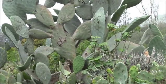
- What is the name of feature seen on the photograph?
- Suggest the type of climate of the area where this photograph was taken.
- List three (3) characteristics of climate suggested in (b) above.
- Suggest two areas in Tanzania where this photography might have been taken.
- With evidences comment on the type of the photograph shown.
- Comment on two (2) uses of feature shown in this photo.
SECTION C (30marks)
Answertwo(02)questions fromthissection
8. a) An announcement from the ministry concerning with industries directed that, government police may play a great role in determining the location of industries, hence the minister argued that, ‘we discourage the concentration of industries in one place” what are the reasons led a minister to argue so? Four points
b) East Africa is struggling to establish several industries so as to fasten the growth of economy. Thus different types of manufacturing industries have been introduced, as an expert in manufacturing, industries identify groups of manufacturing industries in the region concern. Give six groups with vivid examples
9. Mdilidili is a village whereby villagers are walking over long distance to fetch water, how distance to water source from household affect a girl child? Briefly Explain (five points)
10. A Geography teacher at Maji Marefu Secondary school taught his students that “Soil has physical, chemical and biological properties”. With facts and vivid example, you as an expert in Geography clarify six (6) properties of soil which were taught by Geography teacher at Maji Marefu Secondary School to his students.
FORM THREE GEOGRAPHY EXAM SERIES 107
FORM THREE GEOGRAPHY EXAM SERIES 107
THE PRESIDENT’S OFFICE MINISTRY OF EDUCATION, REGIONAL ADMINISTRATION AND LOCAL GOVERNMENT
COMPETENCY BASED SECONDARY EXAMINATION SERIES
GEOGRAPHY-SEPT 2022
FORM THREE
INSTRUCTIONS
- This paper consists of sections A, B and C with a total of ten (10) question.
- Answer All questions in sections A and B and any two (2) questions from section C.
- Map extract of LINDI is provided
- Cellular phones are NOT allowed in the examination room.
- Write your Examination number on every page of your answer booklet (s)
SECTION A (15 MARKS)
PHYSICAL AND MATHEMATICAL GEOGRAPHY
- For each of the items (i) – (x) choose the correct answer from the given alternatives and write its letter besides the item number.
- Which of the following planets is closest to the sun?
- Earth
- Jupiter
- mars
- Mercury
- Neptune
- Overgrazing in Tanzania can lead to environmental problems. Identify the regions might have been affected by the problem;
- Dodoma, Arusha and Shinyanga
- Morogoro, Dar es salaam and Tanga
- Pwani, Mbeya and Rukwa
- Mwanza , Singida and Tabora
- Manyara , Iringa and Dodoma
- when the moon’s shadow casts over the earth’s surface the phenomenon is known as
- Lunar eclipse
- Solar eclipse
- Equinoxes
- Summer solstice
- Winter solstice
- What are the four types of statistical data basing on their nature?
- Individual data, discrete data, raw data and secondary data
- Individual data, discrete data , grouped data and continuous data
- Primary data, secondary data, grouped data and collective data
- Individual data, grouped data, statistical data and discrete data
- Raw data, continuous data , primary data and array data
- The Earth have different evidences that proves that the Earth is spherical. What do you think that this is one among those evidences?
- The four seasons
- The lunar eclipse
- The revolution of the Earth
- The Earth rotation
- The eclipse of the sun
- A drainage pattern which works like a tree with its branches is called
- Radial
- Dendritic
- Centripetal
- Annual
- Trells
- The following arc the element of weather
- Soils, clouds, dew, humidity, rainfall
- Pressure, clouds, sunshine, humidity, winds
- Fog, barometer, humidity, pressure, air mass
- Pressure, humidity, soil, fog, rainfall
- Clouds, sunshine, pressure, humidity, thermometer
- The process of peeling off of rock mass is called
- Disintegration
- Weathering
- Mass wasting
- Erosion
- Exfoliation
- A vertical feature formed out of the solidification of magma within the Earths crust is called
- Localita
- sill
- lopolith
- Dykc
- Phacolith
- Mrs Kilua was wondering how fragments are worn out during collision against each other at Kondoa river during rainy season, her daughter tells her that process is known as ……
- Hydraulic action
- Attrition
- Abrasion
- Corrosion
- Hydrolysis
- Match the items in List A with responses in List B by writing the letter of the correct response beside the item number in the answer booklet provided.
| LIST A | LIST B |
|
|
SECTION B 55 MARKS
Answer all questions in this section
3. Carefully study the map extract of Kigoma (sheet 92/3) provided and answer the following questions;
(a) Identity the features that found in the following grid references
- 923617
- 945599
- 910596
(b) Calculate the area of lake Tanganyika from 570 Southward. Give your answer in Km2
(c) What is the length of the railway line from grid reference 944633 Eastward. Give your answer in Km.
(d) With evidence suggest the type of settlement patterns depicted in the map.
(e) By providing evidences, explain three (3) human economic activities andtwo (2) social activities that might be taking place in the area.
4. Study carefully the data below that show the enrollment of form six students at Bagamoyo secondary school from 1980-1985 the answer the questions that follows;
| YEAR | NUMBER |
| 1980 1981 1982 1983 1984 1985 | 100 150 175 200 225 300 |
a) Present the data above by pie chart
b) Comment on the trend of the pie chart in (a) above
c) What are the merits of using this method Apart from that method use in (a) above. Give three (3) points
d) What are alternative methods that can be used to present the data above? Give two (2) points.
5 (a) Mary is a good cartographer; she intends to produce a contoured map of Morogoro. What type of survey method would you advise her to apply?
(b) Apart from producing contour maps, what is the other significance of the survey you have mentioned in (a) above
(c) Mention and explain uses of any three instruments which are used in method you mentioned in (a) above
6. Most of the students usually get confusion when they are trying to differentiate some terms. As a form three student how can help those students to attempt for the following?
a) Small holder farmers and subsistence farming
b) Connate water and juvenile water
c) Adit mining and panning method
d) Footloose industries and industrial inertia
e) Shooting star and meteorite
7. Study carefully the given photograph below then answer the questions that follow
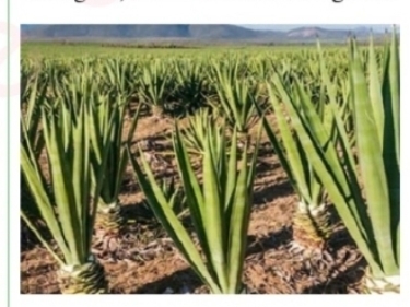
- What is the type of the photograph?
- State the scale of the production
- Outline any four regions in Tanzania where the photograph might have been taken
- What are the three necessary conditions that favour the growth of the crop shown on the photograph above?
- List down any four uses of the crop shown on the photograph
SECTION C (30 MARKS)
Answerany two questions in this section
8. a) An announcement from the ministry concerning with industries directed that, government police may play a great role in determining the location of industries, hence the minister argued that, ‘we discourage the concentration of industries in one place” what are the reasons led a minister to argue so? Four points
b) East Africa is struggling to establish several industries so as to fasten the growth of economy. Thus different types of manufacturing industries have been introduced, as an expert in manufacturing, industries identify groups of manufacturing industries in the region concern. Give six groups with vivid examples
9. Plantation is the most form of agriculture practiced in tropical region of Africa, Asia and South America. Justify six (6) characteristics of plantation practiced in these areas.
10. Explain any six objectives of constructing the striglers gorge of hydro-electric power in Tanzania.
FORM THREE GEOGRAPHY EXAM SERIES 97
FORM THREE GEOGRAPHY EXAM SERIES 97
THE PRESIDENT’S OFFICE
MINISTRY OF EDUCATION, REGIONAL ADMINISTRATION AND LOCAL GOVERNMENT
COMPETENCE BASED SECONDARY EXAMINATION SERIES
GEOGRAPHY TERMINAL EXAMINATION
FORM THREE-2022
INSTRUCTIONS
- This paper consists of sections A, B and C with a total of ten (10) questions.
- Answer all questions in sections A and B and any two (2) questions from section C.
- Map extract of Mkomazi (Sheet 109/1) is provided.
- Programmable calculators, cellular phones and unauthorised materials are not allowed in the examination room.
- Write your Examination Number on every page of your answer booklet(s).
SECTION A (15 Marks)
Answer all questions in this section.
1. For each of the items (i) — (x), choose the correct answer from among the given alternatives and write its letter besides the item number in the answer booklet provided.
(i)If Ronaldo scores a goal for his team playing in Colombo (80°E) at 4:00pm local time, what will be the best time at Mtwara (45°E) Tanzania?
- 1:40pm
- 1:40am
- 1:20pm
- 1:20am
- 6:20am
(ii)The intensity of an earthquake is measured by an instrument called
- Epicenter
- Chronometer
- Seismography
- Ritcher scale
- Hygrometer
(iii)Michewen at sea level has a temperature of 32°C. What is the temperature at Karatu 1500m above sea level?
- 19°C
- 9°C
- 0.6°C
- 17°C
- 23°C
(iv)Which of the following feature is formed by wind erosion?
- Delta
- Lagoon
- Rock Pedestal
- Barchan
- Seif dune
(v)Which of the following has a limestone surface feature?
- Stalagmite
- Underground stream
- Tombolo
- Polje
- Loess
(vi)The sun is overhead at the equator every year on
- 21st June
- 21st March
- 24th March
- 22nd December
- 25th December
(vii)A type of river erosion which increases the length of the river channel is called.
- Headward erosion
- Vertical erosion
- Lateral erosion
- Sheet erosion
- Deep erosion
(viii)Most building materials in Tanzania originated in which type of rock?
- Metamorphic rock
- Sedimentary rock
- Igneous rock
- Plutonic rock
- Conglomerates rock
(ix)Exfoliation is the type of weathering which mostly occurs:
- At higher altitudes
- In chalk and limestone area
- In arid and semi-arid areas
- In humid climates
- In arid and equatorial regions
(x)Why do two different countries located in different latitudes or hemispheres experience a similar type of natural vegetation? It is because of
- Their position which are very far
- Similar traditions of the people living in those areas
- The same type of climate
- Same onshore prevailing wind
- Fertile soil, good cloud cover and rains
2. Match the descriptions of vulcanism in Column A with the corresponding items in Column B by writing the letter of the corresponding answer beside the item number in the answer booklet provided.
| COLUMN A | COLUMN B |
|
|
3. With the aid of a well labelled diagram, describe the underground karts region features.
4.Carefully study the table below which show the use of soft drinks in creates at Chapamaji village then answer the questions that follows
| Types of Soft drink | Coca Cola | Fanta | Pepsi | Mirinda | Novida |
| Number of Crates | 300 | 150 | 250 | 100 | 200 |
- Draw a pie chart to present the data above
- Give three (3) merits and three (3) demerits of the method used above
5. Mr Kazimoto as a chairman of Bajado village conducted a simple chain survey in order to get right measurement of the village farm.
- Show three (3) merits and three (3) demerits of simple chain survey
- Describe five (5) instruments used in surveying the farm.
6.Carefully study the weather data for a station in Australia and answer the questions that follow
| Month | J | F | M | A | M | J | J | A | S | O | N | D |
| Temp(°C) | 28.3 | 27.5 | 28.5 | 29 | 26.7 | 26 | 26 | 25 | 24 | 26 | 27 | 28 |
| Rainfall (mm) | 380 | 330 | 240 | 175 | 170 | 5 | 2.5 | 2.2 | 17 | 50 | 210 | 230 |
- Calculate the annual mean temperature for the station
- Determine the rainfall range
- Find the temperature mode and median
- Comment on the relationship between temperature and rainfall for the station
- Giving two examples, show the application of data in the daily life.
7. Carefully study the photograph below and answer the questions that follow
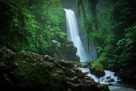
- With two (2) reasons suggest on the types of climates
- Name the type of photograph shown above
- Describe two (2) main physical features found on the photograph
- Examine four (4) economic importance of the features shown on the photograph
SECTION C (30 marks)
Answer two (2) questions from this section
8.Explain six (6) problems facing peasantry agriculture in Tanzania
9.Explain six (6) limitations and six adverse effects of mining industry in African countries
10. It is known that; the earth rotates on its axis while revolving around the sun. Describe the significance of the Earth’s revolution. (Four (4) points)
FORM THREE GEOGRAPHY EXAM SERIES 86
FORM THREE GEOGRAPHY EXAM SERIES 86
THE PRESIDENT’S OFFICE
MINISTRY OF EDUCATION, REGIONAL ADMINISTRATION AND LOCAL GOVERNMENT
SECONDARY EXAMINATION SERIES
GEOGRAPHY MID TERM EXAMINATION
FORM THREE- AUG/SEPT -2021
Time: 3Hours
Instructions.
- This paper consists of section A, B and C with a total of 10 questions
- Answer all questions in section A and B and two questions from section C.
- Section A carries 15 marks, section B 55 marks and section C 30 MARKS
- Map extract sheet for Pangani is provided.
- Programmable calculators, cellular phones and any other unauthorized materials are not allowed in examination room.
- Write your number on every page of your answer booklet.
SECTION A (15 Marks)
Answer All questions in this section.
(i) In the field study, students were told that, soil has certain biological, chemical and physical characteristics. What is the general term for these characteristics?
- soil profile
- soil particles
- soil properties
- soil fertility
- soil formation.
(ii)A girl was crossing a river and accidentally dropped her school bag in the river. The girl cried as she observed her bag being pulled by the river water toward the river mouth. What could the bag named in relation to the river action?
- River erosion
- River transportation
- River load
- River meander
- River bed
(iii) Which of the following layers of the earths interior is made up of sima and sial?
- Biosphere
- Hydrosphere
- Asthenosphere
- Lithosphere
- Barysphere
(iv) Suppose you want to carry out a field study on atmospheric conditions suitable for growth of crops cultivated on a farm within your village. What are the best components of weather to be considered?
- Rainfall and soil
- Moisture and sunshine
- Rainfall and clouds cover
- Temperature and rainfall
- Humidity and rainfall
(v)Prediction of the state of atmosphere in a region for 24 to 48 hours is known as
- weather elements
- weather report
- weather instrument
- weather station
- weather forecasting
(vi) The process of changing granite to gneiss rock is known as
- sedimentation
- vulcanism
- denudation
- metamophism
- exfoliation.
(vii)Which of the following are features of ocean floor?
- Basin, Ocean deep and Cliff.
- Trench, Continental shelf and Stump
- Trench, Ridge and Ocean deep.
- Ocean deep, Continental shelf and Drumlin.
- Basin, Continental shelf and Tombolo.
(viii) Liverpool team scored a goal at 5.00 pm in England (15° W). At what time the goal was scored in Dar es Salaam (45° E)?
- 1.00 p.m
- 7.00 p.m
- 9.45 p.m
- 9.00 p.m
- 6.30 a.m.
(ix) Which of the following planets have small celestial bodies in orbit a round them?
- Mercury, Jupiter and Uranus
- Pluto, Earth a nd Mars
- Earth, Jupiter and Saturn
- Mercury, Venus and Earth
- Venus, Earth and Saturn.
(x) Which of the following is associated with magnitude of an earthquake?
- Richter scale
- Seismography
- Focus
- Epicenter
- Tsunami.
2. Match the items in List A with the responses in List B by writing the letter of the correct response beside the item number in the answer booklet provided.
| LIST A | LIST B |
| (i) Residues that have decomposed and mixed with soil mass. (ii) Status of soil with respect to amount of elements necessary for plants growth. (iii) Removal of materials from surface of land. (iv) Vertical section of the soil to the underlying rocks. (v) Fineness and coarseness of soil particles. |
|
SECTION B (55 Marks)
Answer all questions in this section.
3. Study the map extract of Mkomazi (Sheet 109/1) and then answer the following questions:
- By using the given RF scale, measure the distance of river Pangani in kilometres from grid reference 910771 to 910826.
- Describe relief of the area.
- With reasons, identify two types of rocks found in the map.
- Name the major way used to show the height of the land in the mapped area.
- Using a vertical scale of lcm to represent 50m, draw an annotated cross section from grid reference 960820 to 910880 and mark Ruvu river basin and the main trucks.
4. Read carefully the climatic data for station A presented in the Table and answer the questions that follow:
| Month | J | F | M | A | M | J | J | A | S | O | N | D |
| Temp. in °C | 26.6 | 26.6 | 26.6 | 26.6 | 26.6 | 26.6 | 27.2 | 27.7 | 28.3 | 28.3 | 27.7 | 27.7 |
| Rainfall mm | 233 | 228 | 244 | 215 | 118 | 91 | 36 | 36 | 51 | 104 | 140 | 196 |
(i) Describe the climatic conditions of station A.
(ii) Name any two countries in the Great Lakes of East Africa which experience this type of climatic conditions.
(iii) Present the data graphically.
5. (a) Show the features formed by intrusive land forms
(b) With vivid examples, explain what is lava plateau
6. Study carefully the photograph provided, then answer the questions that follow:
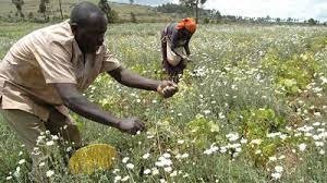
(a) Name the type of photograph provided.
(b) Name the crop shown in the foreground of the photograph.
(c) State the characteristics which favour the growth of the crop in (b) above.
(d) Comment on the stage which might have been reached by the crop mentioned in (b) above.
7. Study the following data showing the age of the Primary School pupils at Tumaini Primary School and answer the questions that follow: 15, 8, 7, 6, 12, 5, 14 and 13.
(i) Determine the range and median of the age of the pupils.
(ii) Calculate the standard deviation.
SECTION C (30 Marks)
Answer two (2) questions from this section.
8. Analyze six potentials of the Rufiji river basin.
9. Elaborate eight reasons indicating why the transportation sector is important to the economy of Tanzania.
10. Explain the main characteristics of nomadic pastoralism in East Africa and suggest the main ways of improving pastoralism in the region.
FORM THREE GEOGRAPHY EXAM SERIES 60
FORM THREE GEOGRAPHY EXAM SERIES 60
THE PRESIDENT’S OFFICE
MINISTRY OF EDUCATION, REGIONAL ADMINISTRATION AND LOCAL GOVERNMENT
SECONDARY EXAMINATION SERIES
GEOGRAPHYTERMINALEXAMINATION
FORM THREE-2021
Time: 3Hours
Instructions.
- This paper consists of section A, B and C with a total of 10 questions
- Answer all questions in section A and B and two questions from section C.
- Section A carries 15 marks, section B 55 marks and section C 30 MARKS
- Map extract sheet for Hanang (Sheet 84/4) is provided.
- Programmable calculators, cellular phones and any other unauthorized materials are not allowed in examination room.
- Write your number on every page of your answer booklet.
SECTION A (15 Marks)
Answer All questions in this section.
1. For each of the items (i) — (x), choose the correct answer from among the given alternatives and write its letter besides the item number in the answer booklet provided.
- The tourists enjoyed the temperature of Zanzibar which was at sea level. They also planned to travel from Zanzibar to Manyara which is 1500m above sea level. What will be the temperature experienced by the tourists in Manyara?
- 230C
- 90C
- 190C
- 0.60C
- 170C
- Which of the following occurs when the moon's shadow cast over the earth?
- Solar eclipse
- Lunar eclipse
- Aphelion
- Summer solstice
- Equinoxes
- Which of the following layers of the earths interior is made up of sima and sial?
- Biosphere
- Hydrosphere
- Asthenosphere
- Lithosphere
- Barysphere
- Mitomingi was wondering the way large amount of soil and rock materials were sliding downward towards the steep slope. What geological processes were occurring in that area?
- Weathering and erosion
- Deposition and transportation
- Weathering and denudation
- Mass wasting and transportation
- Erosion and transportation
- You are asked to help a Form Two student who failed to identify the types of forests found in the area with low temperatures. What type of forest will you suggest among the following?
- Tropical rain forest
- Coniferous forest
- Equatorial forest
- Deciduous forest
- Mediterranean forest
- What is the social-economic advantage of reserved forests to societies?
- Tourism
- Lumbering
- Mining
- Forestry
- Agriculture

- After learning different types of soil texture, students were asked to identify the best type of soil which can be mixed with cement for building a house. What type of soil will be picked by the students who understood the lesson?
- Sandy
- Silt
- Alkaline soil
- Loam
- Clay
- Which among the following is a heavenly body that possesses and transmits its own light?
- Moon
- Sun
- Earth
- Astreroid
- Planet.
- A region which consists of thick forests, tree dwellers and people who engage in cultivation of rubber, cocoa, bananas and oil palms is known as
- Tropical savanna
- Tropical monsoon
- Polar climate
- Mediterranean
- Equatorial.
- Which among the following features are produced by wave erosion?
- Geo, wave cut platform and stack
- Blow hole, sea arch and levee
- Sea arch, beach and stump
- Beach, spit and bars.
- Tombolo, meander and cliff.
2.Match the items in list A with the correct description in list B and write the answer in the space provided.
| LIST A | LIST B |
|
|
SECTION B (55 Marks)
Answer all questions in this section.
3. Carefully study the map extract of Hanang (Sheet 84/4) provided and answer the following questions:
(a) Express the map scale as a statement.
(b) Find the bearing of grid reference 720220 to 680180.
(c) Giving three evidences from the map, suggest the climate of the mapped area.
(d) Suggest with evidence, five major economic activities which might take place in the area.
(e) Give four supportive contents of a topographical map provided.
(f) Mention three factors which affected the contents of the map given.
4. Study the following data showing the production of Irish Potatoes in a thousand (“000”) tones in three villages in Tanzania from 2000 to 2002, then answer the questions that follow:
|
|
Potato production (“000”) | ||
| Sunga | Mwaligulu | Mpera | |
| 2000 | 20 | 15 | 5 |
| 2001 | 40 | 15 | 10 |
| 2002 | 50 | 20 | 10 |
(a) Construct a compound bar graph to show the production of Irish potatoes in the three villages.
(b) Give three advantages and two disadvantages of the compound bar graph.
(c) Suggest any other methods which could be used to present the data provided in the table.
5. (a) (i) Define chain survey.
(ii) Give four principles of chain survey.
(b) Give one reason for each of the following:
(i) Ranging pole has a pointed metal end.
(ii) Note book is important during field study.
(iii) Back bearings are taken during compass survey.
(iv) During surveying, measurements are called back by the booker.
6.Study the following photograph and answer the questions that follow:
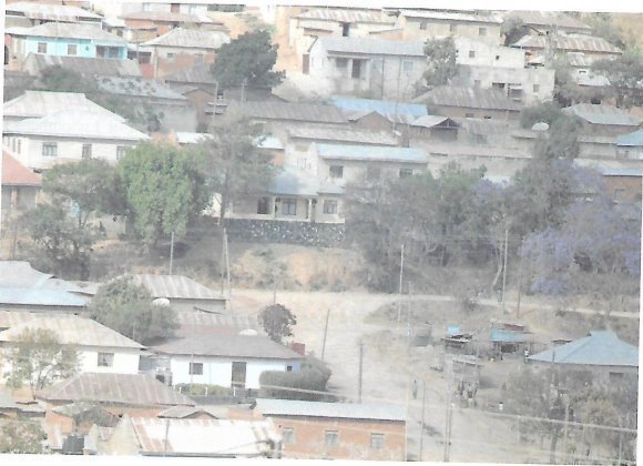
- Giving two reasons, name the type of photograph.
- Suggest the type of settlement pattern and give one factor that has influenced it.
- Suggest two economic activities that might be taking place in the area.
- Provide three advantages of photographs over maps.
7. (a) What is an earthquake?
(b) Briefly explain five effects of earthquakes.
(c) Describe four ways of reducing the risks of earthquakes.
SECTION C (30 Marks)
Answer two (2) questions from this section.
8. Elaborate eight reasons indicating why the transportation sector is important to the economy of Tanzania.
9. By using concrete examples, explain five negative effects of tourism in East Africa.
10. Examine the best ways which can ensure a sustainable use of forestry resources.
FORM THREE GEOGRAPHY EXAM SERIES 53
FORM THREE GEOGRAPHY EXAM SERIES 53
THE PRESIDENT’S OFFICE
MINISTRY OF EDUCATION, REGIONAL ADMINISTRATION AND LOCAL GOVERNMENT
SECONDARY EXAMINATION SERIES
GEOGRAPHY MID TERM EXAMINATION
FORM THREE-2021
Time: 3Hours
Instructions.
- This paper consists of section A, B and C with a total of 10 questions
- Answer all questions in section A and B and two questions from section C.
- Section A carries 15 marks, section B 55 marks and section C 30 MARKS
- Map extract sheet for Sikonge(sheet 137/2) is provided.
- Programmable calculators, cellular phones and any other unauthorized materials are not allowed in examination room.
- Write your number on every page of your answer booklet.
SECTION A (15 Marks)
Answer All questions in this section.
(i). Which of the following is the correct factor for growth in the mining industry?
- Availability of capital
- Absence of labour
- Presence of cities like Dar es Salaam
- Political instability
(ii) Quarts is a compound element of:
- Aluminium and granite
- Reldspar and carbon dioxide
- Manganese and iron
- Iron, granite, carbon dioxide.
(iii) The intensity of an earth quake is measured by an instrument called?
- Epicenter
- Chronometer
- Seismograph
- Ritcher scale.
(iv) The magnitude of the earth quake refers to:
- Effects produced by the earth quake.
- Large amplitude waves known as I- waves.
- Point at which earth shake.
- Total amount of energy released.
(v). Nomadic farming in agricultural activities refers to:-
- Animal keeping through moving from one place to another.
- Permanent cultivation of cash crops
- Keeping animals by zero grazing.
- Crop cultivation of food stuff crops only.
(vi). Which among the following is not a characteristic of shifting cultivation?
- Sites are selected in the virgin forest
- Simple tools are used like hand hoes.
- Few crops are grown, mostly starchy crops
- Keeping animals and crops cultivation
(vii). Plantation in agricultural system is referred to as:-
- Small scale agriculture
- Intensive subsistence farming
- Large scale agriculture.
- Sedentary shifting method.
(viii). A major problem facing river basin development project is:-
- Silting
- Flood
- Diseases
- Land Fragmentation.
(ix) Which among the alternatives is a problem facing Tennessee River valley Authority (T.R.A) scheme?
- Labour shortage
- Siltation
- Diseases
- Environmental degradation.
(x). The following are the hard wood species except?
- Oak, Ash and Beach
- Pines, Far and Spruce
- Oak, Ash and Pines
- Ash, Pines and Cyprus.
2. Match the items from list A with the correct response in List B by writing a letter of the correct answer.
| LIST A | LIST B |
|
|
3. (a) Define the term Climate.
(b).What is the difference between climate and weather?
(c). what is the importance of climate to human activities.
4. (a) Give five factors which control the distribution of temperature
(i) ………………………………………………………………………
(ii) ………………………………………………………………………
(iii) ………………………………………………………………………
(iv) ……………………………………………………………………….
(v) ………………………………………………………………………..
(b) State four types of clouds
(i) ………………………………………………………………………
(ii) ………………………………………………………………………
(iii) ………………………………………………………………………
(iv) ……………………………………………………………………….
(c) Mention four importance of weather forecasting
(i) ………………………………………………………………………
(ii) ………………………………………………………………………
(iii) ………………………………………………………………………
(iv) ……………………………………………………………………….
5. (a) Give three methods used to measure the distance of maps
(i) ……………………………………………………………………………
(ii) ……………………………………………………………………………
(iii) ……………………………………………………………………………
(b) Mention three ways on how map scale can be expressed
(i) ………………………………………………………………………
(ii) ………………………………………………………………………
(iii) ………………………………………………………………………
(c) If a statement scale is 1cm to 0.5km, calculate how many meters will be represented by 1cm.
(d). Change the following scales into the required formats.
a) 150cm to Kilometres if the map scale is 1:25,000
b) The distance of 800cm if the scale is 1:20,000
c) Change 1:100,000 into statement scale.
d) Draw a linear scale to read 1:50,000 if the ground distance is 20km
6. (a) Distinguish between volcanism and volcano.
(b) Classify rocks according to mode of formation.
(c) Identify three minerals that are found in igneous rocks.
7. (a) Briefly explain the following process involved in weathering;i) freeze-thaw, solution and exfoliation.
(b) Outline three factors that influence the rate of chemical weathering
SECTION C. (30 Marks)
Answer two (02) questions from this section.
8. (a) Explain the effects of rapid population growth on small scale farming.
(b) What are the advantages of small scale agriculture? (Give five (5) points)
9. Briefly explain measures taken by the government of Tanzania in alleviating problems facing livestock keeping.
10. Discuss the main problems facing mining industry in Tanzania.
FORM THREE GEOGRAPHY EXAM SERIES 44
FORM THREE GEOGRAPHY EXAM SERIES 44
PRESIDENT’S OFFICE
REGIONAL ADMINISTRATION AND LOCAL GOVERNMENT
FORM THREE ANNUAL EXAMINATIONS
013GEOGRAPHY
(For Both School and Private Candidates)
Time: 3:00 HoursDecember 2020 p.m.
Instructions
- This paper consists of sections A, B and C, with total of ten (10) questions
- Answer ALL questions in section A and B and two (2) questions from section C
- Map extract of (265/2) Ilonga Sheet is provided
- Credit will be given for the use of recreant diagrams
- Write your examination number on each answer sheet you have used.
SECTION A (15 Marks)
Answer all questionsin this section
1. For each of the items (i) – (x), choose the correct answer from among the given alternatives and write its letter besides the item number in the answer booklet provided.
(i)What is a proper name for the study of the description of the earth?
Asolar system
BAstronomy
CGeography
DEnvironment
EMetrology
(ii)You have been visited the coastal area of Bagamoyo and you find the forests with deep roots and roots project above the mud and water to absorb oxygen, what kind of forest is that?
ATropical forest
BMangrove forest
CConiferous forest
DDeciduous forest
ETemperate forest
(iii)If the time at town X is 150E is 12:00 noon what could be the longitude town Y if it is 8:00 am?
A150E
B300W
C300E
D450W
E450E
(iv)Mrs Kilua was wondering how fragments are worn out during collision against each other at Kondoa river during rainy season, her daughter tells her that process is known as ……
AHydraulic action
BAttrition
CAbrasion
DCorrosion
EHydrolysis
(v)The Maasai around Oldonyo Lengai mountain were wondering the way mountain vomiting fire and smoke, they believe that the mountain was possessed by bad evils, tell them is not evils but is …………..
AVolcanic eruptions
BTectonic movements
CMass wasting
DFire from God
EFaulting
(vi)Suppose you want to carry out a field study on the atmospheric conditions suitable for growth of maize on a farm village. What are the best weather components to be considered…?
ARainfall and wind
BRainfall and could cover
CMoisture and sunshine
DRainfall and temperature
EPressure and humidity
(vii)Last year people of Bukoba District experience shaking of crustal rocks which lead to destruction of properties and death of people. Where this shaking does originated inside the earth’s crust?
AAt the focus
BAt the epicentre
CAt the fault
DAt the Lake Victoria
(viii)The process of peeling off and falling of rock mass is called
ADisintegration
BWeathering
CMass wasting
DErosion
EExfoliation
(ix)Workers who were working at Government offices in Dar es salaam are now moving to Dodoma as their new offices. Identify the type of that movement
AMigrants
BEmigrants
CEmigration
DImmigration
EImmigrants
(x)Recently in Rwanda the land with their vegetation was sliding down a slope and people were busy in taking photos and wondering to that situation, tell them what type of geological process was taking place
AErosion and deposition
BDenudation and transportation
CLand slide and erosion
DMass wasting and transportation
ELandslide and deposition
2.Match the letter of the correct response beside the item number in the answer sheet provided.
| LIST A | LIST B | |
| i | Fineness and coarseness of soilparticles | A. Soil type B. Soil profile C. loam soil D. soil texture E. Soil structure F. Soil fertility G. Soil organic matters H. Soil chemistry I. Soil erosion J. Soil water K. Soil air |
| ii | Removal of materials from surface of land | |
| iii | Vertical section of the soil to the underlying rocks | |
| iv | Status of soil with respect to amount of elements necessary for plants growth | |
| v | Residues that have decomposed and mixed with soil mass | |
SECTION B (55 Marks)
Answer all questions from this section
3Study the map extract of Ilonga (sheet 265/2) and answer the following questions.
- Measure the distance covered by the river in kilometre from grid reference 630000 to 600979
- Use the square methods to calculate the area covered by Namihondo pond.
- With evidence, mention three (3) economic activities which may be conducted on a mapped area
- Describe the nature of relief of the area
- With one reason, suggest the type of climate
- Identify any three (3) factors which have influenced the population distribution of Ilonga town.
4.Carefully study the data below which shows the exports of tea from Kilimanjaro in tones.
| YEAR | TEA PRODUCTION (In Tonnes) |
| 1981 | 7,000 |
| 1982 | 3,000 |
| 1983 | 10,000 |
| 1984 | 5,000 |
| 1985 | 2,000 |
| 1986 | 12,000 |
| 1987 | 16,000 |
| 1988 | 6,000 |
| 1989 | 15,000 |
| 1990 | 3,500 |
a)Name the two simplest methods of presenting the data
b)Outline two values of presenting the data by simple methods mentioned in (a) above
c)Present the given statistical data by using divergent bar graph.
5. (a)What is meant by Moraine erosion?
(b) Describe four (4) processes which are involved in Moraine erosion.
6.(a) Distinguish fold mountains from volcanic mountains
(b) Briefly explain how the rift valley is formed
7.Study carefully the photograph below then answers the questions that follow: -
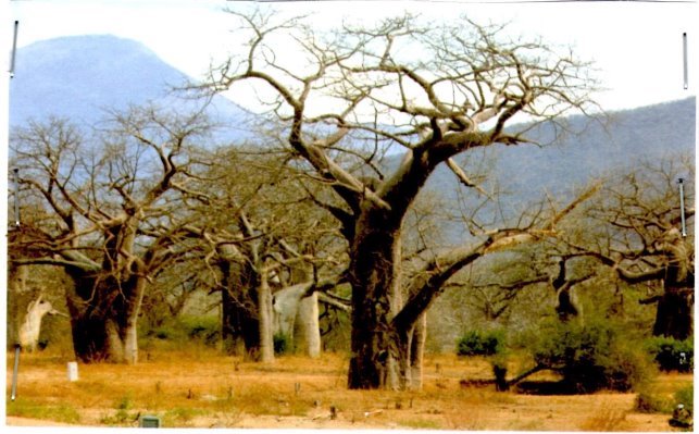
- Name the type of photograph
- Describe the possible climate of the area
- Suggest four economic activities that might be taking place in the area
- Suggest three possible regions in Tanzania where the photograph might have been taken
SECTION C. (30 Marks)
Answer two (2) questions from this section.
8.Explain any six objectives of constructing the Stigler’s gorge hydro- electric power in Tanzania.
9.Mage’s grandmother used to cultivate many crops in small area, using local seeds and hand hoe and now she is blaming that she harvests nothing in five years and she is complaining that her neighbours are the one who cause this problem. Explain to her six ways on how she can improve her farming system instead of complaining to her neighbours.
10.Explain six human factors which influences population distribution and density in Tanzania
FORM THREE GEOGRAPHY EXAM SERIES 38
FORM THREE GEOGRAPHY EXAM SERIES 38
THE PRESIDENT'S OFFICE
MINISTRY OF REGIONAL GOVERNMENT AND LOCAL GOVERNMENT
AUGUST-SEPTEMBER EXAMINATION SERIES
GEOGRAPHY FORM-3
2020
TIME: 2:30 HRS
Instructions
- This paper consists of sections A, B and C with a total of ten (10) questions.
- Answer all questions in sections A and B and any two (2) questions from section C.
- Map extract of Mkomazi (Sheet 109/1) is provided.
- Programmable calculators, cellular phones and unauthorised materials are not allowed in the examination room.
- Write your Examination Number on every page of your answer booklet(s).
SECTION A (15 Marks)
Answer all questions in this section.
1. For each of the items (i) — (x), choose the correct answer from among the given alternatives and write its letter besides the item number in the answer booklet provided.
(i) Which of the following layers of the earths interior is made up of sima and sial?
- Biosphere
- Hydrosphere
- Asthenosphere
- Lithosphere
- Barysphere
(ii) You are asked to help a Form Two student who failed to identify the types of forests found in the area with low temperatures. What type of forest will you suggest among the following?
- Tropical rain forest
- Coniferous forest
- Equatorial forest
- Deciduous forest
- Mediterranean forest
(iii) What is the social-economic advantage of reserved forests to societies?
- Tourism
- Lumbering
- Mining
- Forestry
- Agriculture
(iv) Which of the following instrument is used to measure maximum and minimum temperature?
- Barometer
- Thermometer
- Anemometer
- Sixs thermometer
- Hydrometer.
(v) Which among the following is an extrusive volcanic feature?
- Crater
- Laccolith
- Batholith
- Sills
- Dykes.
(vi) A region which consists of thick forests, tree dwellers and people who engage in cultivation of rubber, cocoa, bananas and oil palms is known as
- Tropical savanna
- Tropical monsoon
- Polar climate
- Mediterranean
- Equatorial.
(vii)Which of the following is not a process for chemical weathering?
- Carbonation
- Saltation
- Hydrolysis
- Hydration
- Oxidation.
(vii) Which among the following features are produced by wave erosion?
- A Geo, wave cut platform and stack
- Blow hole, sea arch and levee
- Sea arch, beach and stump
- Beach, spit and bars.
- Tombolo, meander and cliff.
(ix) The process through which rain water enters the ground is called
- Evaporation
- Infiltration
- Transpiration
- Condensation
- Percolation.
(x)The process of peeling off and falling of rock mass is called
- disintegration
- weathering
- mass wasting
- erosion
- exfoliation.
2. Match the process involved in the formation of rocks in with the type of rock in List B by writing the letter of the correct response beside the item number in the answer booklet provided.
| LIST A | LIST B |
|
|
SECTION B (55 Marks)
Answer all questions in this section.
4. Carefully study the map extract of Arusha (Sheet 55/3) provided then answers the questions that follow.
- Describe the relief of the mapped area.
(b) Giving evidences, mention the major means of transport shown in a map.
(c) Change the scale of the map into a statement scale.
(d) Measure the length of the road from grid reference 378314 to grid reference 480276 in kilometres.
(e) With evidence from the map, identify three social services which are found in this area.
 |
5. (a) Define compound bar graph.
(b) Study carefully the table below on hypothetical data about cash crops production (in ‘000 tonnes) in East Africa in the year 2000, then answer the questions that follow. Find this
| Country | Crops |
| |
| Coffee | Tea | Cotton | |
| Kenya | 2200 | 2000 | 1800 |
| Uganda | 1700 | 700 | 800 |
| Tanzania | 1300 | 1900 | 2300 |
(i) Draw compound bar graphs to represent the data provided.
(ii) Outline four merits of using compound bar graph.
5. (a) Explain two major forms of measurements in land surveying.
(b) (i) Define leveling.
(ii) Explain four significances of leveling.
6. (a) What is an earthquake?
(b) Briefly explain five effects of earthquakes.
7. Carefully study the photograph given below then answer the questions that follow:
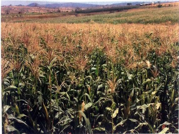
(a) Name the type of photograph.
(b) Describe the relief of the area.
(c) Giving two reasons, describe the scale of production of the crop in the photograph.
(d) Explain two uses of the crop in the photograph.
(e) Describe three conditions necessary for the production of the crop.
SECTION C (30 Marks)
Answer two (2) questions from this section.
8. Give five reasons for decreasing death rates in many parts of the world.
9. Explain eight characteristics of shifting cultivation.
10. Describe six problems facing railway transportation in East Africa.
FORM THREE GEOGRAPHY EXAM SERIES 26
FORM THREE GEOGRAPHY EXAM SERIES 26
THE PRESIDENT’S OFFICE MINISTRY OF EDUCATION, LOCAL ADMINISTRATION AND LOCAL GOVERNMENT
GEOGRAPHY- TERMINAL EXAMINATION-MAY
FORM THREE
TIME: 3:00HRS 2020
NAME:_______________________________________________ CLASS:___________
INSTRUCTIONS
- This paper consists of sections A,B,C and D
- Answer All questions in section A,B and C and ONE (1) question from each part in section D
- Map extract of ENGARUKA BASIN sheet 54/1 is provided
- Credits will be awarded for the use of relevant diagrams and examples
- All writings must be done in BLUE or Black ink except for the diagrams which must be done by pencil
- Remember to write your name and class in the spaces provided above.
SECTION A (25 MARKS)
1. For each of the items (i-x), choose the correct answer among the given alternatives and write its letter beside the item number in the box provided.
(i) Great circle refers to:-
- A line of longitude
- Greenwich meridian only
- A line of the globe
- The shortest distance between the two points
- A circle in the surface whose plane passes through the centre of the globe.
(ii) Pangani at sea level has a temperature of 32C, what is the temperature of Arusha 1500M above the sea level?
- 230c
- 170c
- 90c
- 190c
- 0.60c
(iii) Plants with long roots, thorny stems, needle shaped leaves, wax or hair are found in:-
- The monsoon region
- Tropical grasslands
- Hot deserts
- The Mediterranean region
- The equatorial region
(iv) The slow movement of soil particles which can be recognized by bending of trees and fences is referred to as:-
- Soil erosion
- Mud flow
- Land slide
- Rock fall
- Soil creep
(v) The secretary general of the U.N addressed the world from New York (75w 42N) at 7:30p.m Tuesday. At what time and day will the people in Dar es Salaam (45E 06S) hear the same speech?
- 3:30p.m Wednesday
- 12:30p.m Tuesday
- 3:30a.m Wednesday
- 8:30p.m Tuesday
- 11:30p.m Wednesday
(vi) The barysphere of the earth is made up of:
- Silica and magnesia
- Iron and aluminia
- Silica and aluminia
- Iron and nickel
- Iron and Zinc
(vii) The name given to the boundary that demarcates solid materials from the molten mantle is:
- Mohorovicic
- Mesosphere
- Core
- Astheriosphere
- Gutenberg
(viii) _____________is a point where cold air from the polar regions meet warmer air from lower latitudes
- Pressure gradient
- Humidity
- Tropical maritime
- Polar front
- Cyclone
(ix) Which one of the following combinations form chemical weathering?
- Organic acid and temperature change
- Exfoliation and carbonation
- Organic acid and weak carbonic acid
- Mud flow and land slides
- Temperature change and frost action
(x) The earth is said to be oblate spherical because it is:
- A flattened sphere
- Spherical in shape
- Has a flattened surface
- Round
- A planet
2. Match the items in list A with the response in list B by writing the letter of the correct response beside the item number.
| LIST A | LIST B |
| (i) The earth’s zone which is made up of nickel and iron (ii) Magma which reaches the earth’s surface and solidifies to form extrusive features (iii) A sheet of magma which lies along the bedding plane (iv) A wall like feature formed when a mass of magma cuts across the bedding plane (v) The uppermost layer of the earth |
|
SECTION B (27 MARKS)
3. a) What do you understand by “Earthquake”?
b) Briefly explain five effects of earthquakes
c) Describe four ways of reducing the risks of earthquakes
4. (a) What is data in statistics?
(b) Explain with examples the following terms
- Individual data
- Discrete data
- Continuous data
- Grouped data
5. There are a number of researches conducted from different areas across the world. Suggest four advantages of research findings to Tanzania as a developing country after giving the definition of the word research”
6. a) Define surveying.
b) When someone wants to conduct a survey he/she has to prepare himself/herself before. Explain four (4) important things a surveyor has to prepare before deciding to conduct a chain survey.
7. Study carefully the map extract of ENGARUKA BASIN sheet 54/1 and then answer the questions that follow:
- Calculate the area covered by seasonal swamp in square kilometer (km2)
- With evidence from the map suggest two economic activities which might take place in the mapped area
- Name the features found at the following grid reference 875658 and 840580
- Describe the relief features found in a mapped area
- Change the map scale into statement scale
8. Study carefully the photograph provided below then answer the questions that follow:
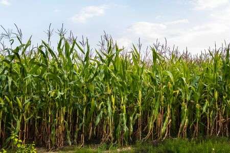
- With reasons suggest the type of photograph above
- Name the crop shown in the photograph
- Mention the natural conditions which favor the growth of the crop above
- Tanzania is very famous in growing the crop mentioned (b) above. Name three regions of Tanzania which grow the crop at commercial level
- With concrete evidence, explain the scale of production as shown on the photograph
SECTION C 30 MARKS
9. Explain the factors that influence the exploitation of mineral resources.
10. With vivid examples explain the factors which contribute to the drastic movement of people from rural to urban areas.
11. How does rapid population explosion affect small scale agriculture?
FORM THREE GEOGRAPHY EXAM SERIES 17
FORM THREE GEOGRAPHY EXAM SERIES 17
THE PRESIDENT’S OFFICE
REGIONAL GOVERNMENT AND LOCAL GOVERNMENT
MID TERM EXAMINATIONS- MARCH 2020
033/1 GEOGRAPHY FORM THREE
Time: 3Hours
Instructions:
- This paper consists of sections A, B and C with a total of TEN (10) questions.
- Answer all questions in sections A and B and two (2) questions from section C
- All writing should be in blue or black pen, except for diagrams that must be drawn in pencil.
- Cellular phones and any unauthorized materials are not allowed in the examination room.
- Write your Examination Number on every page of your answer booklet(s)
SECTION A: 25 marks
Answer all questions in this section.
1. For each of the items i-x choose the correct answer from among the given alternatives and write its letter behind the item number.
(i) Autumn, winter, spring and summer are the result of:-
(a) Monsoon
(b) Lunar eclipse
(c) Rotation
(d) Revolution
(e) Tides
(ii) Which of the following is not a factor influencing temperature of a place?
(a) Aspect
(b) Ocean current
(c) Altitude
(d) Eclipse
(e) Length of a day
(iii) Which among the following features is the impact of water action in the desert?
(a) Yardang
(b) Gullies
(c) Bad lands
(d) Sinkholes
(e) Rock pedestals
(iv) What is the direction of 22![]() ?
?
(a) SES
(b) NEN
(c) NWN
(d) SWS
(e) None of the above
(v) Which of the following is formed due to depositional features of the river?
(a) Water fall
(b) Delta
(c) Hanging Valley
(d) Tombolo
(e) Cirque
(vi) The maximum and minimum temperature are obtained from an instrument called?
(a) A barometer
(b) A Six’s thermometer
(c) An anemometer
(d) Kilometer
(vii) The solar system is made up of:-
(a) Sun, planets and interplanetary gases
(b) Atmosphere and hydrosphere
(c) Planets, clouds and gases
(d) Hydrosphere, atmosphere and clouds
(viii) A delta which is formed in a lake is called ………delta
(a) Moraine
(b) Laustrine
(c) Alluvial
(d) Acute
(e) Cuspate
(ix) What is the compass bearing of WNW?
(a) 27![]()
(b) 33![]()
(c) 31![]()
(d) 32![]()
(e) 292.![]()
(x) Destruction, wastage and removal of parts of the earth’s surface;
(a) Denudation
(b) Frost action
(c) Exfoliation
(d) Deposition
2. Match the items in LIST “A” with the responses in LIST B by writing the letter of the correct response below the corresponding item number in the table provided.
| List A | List B |
|
|
3. (a) What is meant by Moraine erosion?
(b) Describe four (4) processes which are involved in Moraine erosion.
4. Study the data in the following table and answer the questions that follow.
Environmental Workers In Ten Streets Of Arusha City.
| STEET | A | B | C | D | E | F | G | H | I | J |
| NUMBER OF WORKERS | 12 | 06 | 20 | 03 | 12 | 02 | 12 | 03 | 18 | 09 |
(a) Find the range of workers in this city.
(b) Calculate the (i) Mean (ii) Median (iii) Mode of these workers.
(c) Calculate variance and standard deviation of the workers.
5. (a) Describe the following terms;
- distributaries
- lagoon
- levee
(b) Delta is formed under different conditions. Outline three conditions necessary for its formation.
6. Study carefully photograph provided then answer the questions that follows.

(a) Suggest the title of photograph
(b) (i) Name the type of forest seen in the photograph
(ii) Give two characteristics of the forest named in (i)
(c) Outline three ways of interpreting the photograph given
(d) (i) Identify the product in the middle ground of the photograph
(ii) Give two uses of the product in the middle ground of the photograph.
SECTION C:
Answer only one question in this part.
7. Explain seven ways of improving tourism Industry in Tanzania.
8. Elaborate the problems hindering development of agriculture sector in Tanzania.
9. Analyze five ways of promoting textile industry in Tanzania.
10. Explain the significance of Natural gas production in Tanzani
FORM THREE GEOGRAPHY EXAM SERIES 5
FORM THREE GEOGRAPHY EXAM SERIES 5

DOWNLOAD LEARNING HUB APP NOW

SORRY, YOU CAN'T VIEW THIS MARKING SCHEME PLEASE DOWNLOAD LEARNING HUB APP FROM PLAYSTORE TO GET FULL ACCESS TO ALL MARKING SCHEME!!
Click Here To Download Learning Hub Tanzania App
SAMAHANI, HUWEZI KUFUNGUA MAJIBU YA MTIHANI, TAFADHALI PAKUA APP YA LEARNING HUB TANZANIA ILI KUWEZA KUFUNGUA MAJIBU YA MITIHANI KATIKA TOVUTI HII!!
Bofya Hapa Kupakua App Ya Learning Hub Tanzania
Hub App
 For Call,Sms&WhatsApp: 255769929722 / 255754805256
For Call,Sms&WhatsApp: 255769929722 / 255754805256  MATOKEO YA KIDATO CHA VI 2026
SECONDARY REGIONAL EXAMS
PRIMARY REGIONAL EXAMS
FORM VI NECTA REVIEWS
FORM IV NECTA REVIEWS
FORM II NECTA REVIEWS
STD VII NECTA REVIEWS
STD IV NECTA REVIEWS
SECONDARY EXAMS SERIES
PRIMARY EXAMS SERIES
PRIMARY SUBJECT NOTES
SECONDARY SUBJECT NOTES
SECONDARY TOPICAL EXAMS
SECONDARY TOPICAL QUESTIONS
PRIMARY TOPICAL QUESTIONS
PRACTICAL EXAMS & NOTES
SECONDARY REGIONAL EXAMS
DOWNLOAD SUBJECT NOTES
SCHEMES OF WORK (PRIMARY & SECONDARY)
LESSON PLAN
SECONDARY LOG BOOKS
PRIMARY LOG BOOKS
LITERARY WORKS / UCHAMBUZI VITABU
METHALI ZOTE ZA KISWAHILI
Vitendawili Vya Kiswahili
FORM VI RESULTS 2024
FORM FIVE SELECTION 2024
Matokeo KIDATO CHA II 2024
Matokeo Darasa IV 2024
MATOKEO KIDATO CHA IV 2023
FORM ONE SELECTION 2024
FORM VI RESULTS 2023
Matokeo Darasa IV 2022
MATOKEO YA KIDATO CHA VI 2026
SECONDARY REGIONAL EXAMS
PRIMARY REGIONAL EXAMS
FORM VI NECTA REVIEWS
FORM IV NECTA REVIEWS
FORM II NECTA REVIEWS
STD VII NECTA REVIEWS
STD IV NECTA REVIEWS
SECONDARY EXAMS SERIES
PRIMARY EXAMS SERIES
PRIMARY SUBJECT NOTES
SECONDARY SUBJECT NOTES
SECONDARY TOPICAL EXAMS
SECONDARY TOPICAL QUESTIONS
PRIMARY TOPICAL QUESTIONS
PRACTICAL EXAMS & NOTES
SECONDARY REGIONAL EXAMS
DOWNLOAD SUBJECT NOTES
SCHEMES OF WORK (PRIMARY & SECONDARY)
LESSON PLAN
SECONDARY LOG BOOKS
PRIMARY LOG BOOKS
LITERARY WORKS / UCHAMBUZI VITABU
METHALI ZOTE ZA KISWAHILI
Vitendawili Vya Kiswahili
FORM VI RESULTS 2024
FORM FIVE SELECTION 2024
Matokeo KIDATO CHA II 2024
Matokeo Darasa IV 2024
MATOKEO KIDATO CHA IV 2023
FORM ONE SELECTION 2024
FORM VI RESULTS 2023
Matokeo Darasa IV 2022


