STUDENT’S NAME: _____________________
PRIME MINISTER'S OFFICE REGIONAL ADMINISTRATION AND LOCAL GOVERNMENT
FORM ONE TERMINAL JOINT EXAMINATION
CODE: 013 GEOGRAPHY
TIME: 2:30 HRS MAY, 2026
INSTRUCTIONS:
- This examination comprises 10 questions in total.
- Read all questions and attempt them carefully in SECTION A, B and C.
- All writings must be in blue/black ink and drawings in pencilS
| FOR EXAMINER’S USE ONLY | ||
| Question No | SCORE | EXAMINER’S INITIALS |
| 1 | ||
| 2 | ||
| 3 | ||
| 4 | ||
| 5 | ||
| 6 | ||
| 7 | ||
| 8 | ||
| 9 | ||
| 10 | ||
| TOTAL | ||
| CHECKER’S INITIALS | ||
SECTION A: 16%
1. For each of the items (i-x) choose the correct answer from among the given alternatives and write the answers in the table given below
i. Mr Benard is well known in his community as mountain climber, one day he climbed a side of a mountain facing the direction of the wind. What is the name given to that direction?
- Foreside
- Leeward side.
- Backward
- Mountain side
ii. Marry is a form one geography teacher, during the lesson she said that the earth is not upright but is inclined in its orbit at a angle.
- 20°
- 22.5°
- 23.5°
- 21.5°
iii. Our earth is always in motion, it rotates from to .
- East to West
- West to South
- East to North
- West to East
iv. What's the geographical name given to the part of the eart faces the sun?
- Equinox
- Night
- Day
- Overnight
v. Mr Julius lives in West side of the International Date Line(IDL) while mr Amani lives in East side of it. What will happen if mr Julius will decided to move to mr Amani side?
- He will loose 24 hours.
- He will loose 30 minutes
- He will gain 45 minutes
- He will gain 24 hours
vi. The world experiences seasons with distinct features in temperature and rainfall. The following are the seasons the world experiences, except
- Winter
- Sponge
- Autumn
- Summer
vii. The imaginary line that separates the earth into two sides-the Northern hemisphere and southern hemisphere. That line is called?
- Greenwhich
- International Date Line
- Equator
- Meridians
viii. As a form one student, identify the geographical word that given when the earth is located approximately 152 millions kilometres away from the sun?
- Equinox
- Aphelion
- Solstice
- Perihelion
ix. According to the Geographers beliefs, in the eclipse of the sun, one heavely body passes through two heavenly bodies. What is that body passes between the two?
- Earth
- Sun
- Moon
- Asteroid
x. Geomorphologist suggested that the earth is composed of both landmass and water bodies. To what exactly percentages at each comprised on earth?
- Landmass 75% and water bodies 25%.
- Water 70% and land mass 30%
- Water bodies 29% and landmass 71%
- Water bodies 71% and land mass 29%
Answers
| i | ii | iii | iv | v | vi | vii | viii | ix | x |
| . |
2. Read the items in column A and match with the correlating item in column B
| COLUMN A | COLUMN B |
|
|
Answers
| List A | i | ii | iii | iv | v | vi |
| List B |
SECTION B: 54%
3. Sam is a form one student in a certain secondary school in Morogoro district, he was given a task to prepare a short notes on continent existed in the earth.
- List seven continents
- What is the name given to the unhabitable continent in the world?
4. Our precious earth distinguishes itself from other planets in the solar system, by its ability to support life of living things (flora and Fauna). List four reasons how earth sustain it?
5. The Austronomous and Geophysist suggest that solar system comprises certain things. List four components of the solar system
6. Through studying geography students expects to reach their carriers, as they consider it as a tap root. List five carriers that the students wish to be
7. As a young geographer, how do you explain the branches of geography?
8. The scientists categorized planets as the outer planets and the inner ones. With the help of a well labelled diagram, draw the solar system and show the position of the planets accordingly.
SECTION C: 30%
Answer all questions
9. Mwanahamis got grade D in geography, this makes her to dislike the subject. As a form one student, advices her to like the subject by explaining five importance of studying Geography in to days world.
10. Two students were in argument on the shape of the earth, one said the earth is flat and the another said the earth is spherical. Assume they come to you, what are you going to educate them with reasons? With the aid of diagrams, explain five points.
FORM ONE GEOGRAPHY EXAM SERIES 267
FORM ONE GEOGRAPHY EXAM SERIES 267
Candidate’s NAMES: _____________________
PRIME MINISTER’S OFFICE REGIONAL ADMINISTRATION AND LOCAL GOVERNMENT
FORM ONE TERMINAL EXAMINATION
013 SUBJECT: GEOGRAPHY
FORM ONE
Time: 2:30 Hours MAY 2026
Instructions
- This paper consists of sections A, B and C with a total of ten (10) questions.
- Answer all questions in section A, B and section C.
- Section A carries fifteen (15) marks, section B seventy (70) marks and section C carries fifteen (15) marks.
- All writing must be written in space provided.
SECTION A (15 Marks)
Answer all questions in this section.
1. For each of the items (i) - (x), choose the correct answer from among the given alternatives and write its letter in the box provided.
(i) The solar system is made up of the sun, planets and other heavenly bodies which revolve around the sun. Which planet is called dwarf planet .
- Mars
- Pluto
- Earth
- Jupiter
(ii) Day and night are caused by :
- Earth ‘s rotation
- Earth ‘s revolution
- distance of the earth from moon
- eclipse of the moon
(iii) Which planet has a shape which is different from the others?
- Earth
- Jupiter
- Saturn
- Mars
(iv) Which of the following bodies does not move in space?
- The sun
- The earth
- The moon
- The planet
(v) Which of the following is true regarding satellites?
- All satellites are bigger than the earth.
- All planets have satellites
- The moon is a satellite which produces its own light
- There are planets with more than one moon
(vi) A form one teacher taught that the earth is said to be Oblate spheroid because its
- Spherical in shape
- a flattened sphere
- Has a flattened surface
- Round
(vii) Form two students at Salala Secondary School wanted to measure wind speed of their Surroundings, which instrument they will use:
- Wind vane
- Barometer
- Hygrometer
- Anemometer
(viii) How many planets are there in the solar system ?
- A. seven
- B. Eight
- C. Nine
- D. Not known
(ix) Which of the following is true regarding the earth?
- It is the third largest planet in the solar system
- It is the only planet which support life
- It has average temperature of 100 centigrade
- It revolves to an orbit of others planet
(x) The occurrence of Summer, spring, winter, and autumn is the result of:
- Earth revolution
- Earth rotation
- Ferrell’s law
- Tilting of the earth.
2. Match the descriptions of the solar system in List A with their corresponding term in List B by writing the letter of the correct response below the corresponding item number in the table provided.
| List A | List B |
| (i) It is a planet which has a ring around it. (ii) Piece of hard matter falling from other spaces . (iii) The sun together with all the planets and other bodies that revolves around it. (iv) Made up of hot gases mainly hydrogen and helium. (v) Objects with leading heads and bright tails in the sky. |
|
SECTION B (70 Marks)
Answer all questions in this section
3. (a) Describe two branches of Geography.
(b).(i) Explain the original term geography
(ii)Explain the meaning of geography
4. Define the term solar system and draw a well diagram of our solar system.
5. Geography is the subject which is so helpers to the users, briefly explain the five importance of studying geography?
6. a)With examples explain the meaning of solar energy.
b) What are the uses of solar energy in our daily life?
7. Differentiate between meteors and meteorites?
8.Briefly provides some explanation on the following terms?
- Comets
- Asteroids
- Satellites
9. Chengula and Samofi were taught by their Geography teacher that Geography has good relationship with other subjects. By using six subjects briefly explain the relationship between Geography and those subjects.
SECTION C (15 Marks)
10.With the aid of diagram, explain the five evidence to prove that the earth was spherical in shape.
FORM ONE GEOGRAPHY EXAM SERIES 257
FORM ONE GEOGRAPHY EXAM SERIES 257
PRIME MINISTER’S OFFICE REGIONAL ADMINISTRATION AND LOCAL GOVERNMENT
FORM ONE MIDTERM EXAMINATION MARCH 2026
013 GEOGRAPHY
Time: 2:30 Hours
Instructions
- This paper consists of sections A, B and C with a total of ten(10) questions.
- Answer all questions in the space provided.
- Section A carries fifteen(15) marks, section B carries seventy(70)marks and section C carries fifteen(15)marks.
- All writing must be in blue or black ink, except drawings which must be in pencil
SECTION A (15Marks)
Answer all questions in this section.
1.For each of the items (i) -(x) choose the correct answer from the given alternatives and write its letter in the box provided.
(i) The earth is the only planet in the solar system that support life.Its surface is made up of
- land and water
- rocks and gases
- Interplanetary dust and gases
- dark matter
(ii) The theory that explain the complex problems of the origin and characteristics of the solar system and the earth
- The creation theory
- The Inter stellar dust hypothesis
- The big bang theory
- Nebular hypothesis
(iii) Form one student was arguing about the shape of the earth.As knowledgeable student the shape of the earth is
- Perfect sphere
- Cycle
- Flattened sphere
- Oblate
(iv) Some people were transporting watermelons from Tanga to Arusha.The activities undertaken by these people may be studied in the branch of geography known as
- Human geography
- Physical geography
- Practical geography
- Chemical geography
(v) The seasons of the year are caused by
- Rotation of the earth
- Revolution of the earth
- Lunar eclipse
- Solar eclipse
(vi) The theory that explain the origin of the universe is known as
- The big bang theory
- The continental drift theory
- The Nebular hypothesis
- The plate tectonic theory
(vii) The main source of energy on the earth is
- Wind
- Water
- The sun
- Natural gas
(viii) Branches of geography includes
- Human,economic and regional
- Physical,regional and practical
- Practical, human and regional
- Practical,environmental and regional
(ix) Identify the correct arrangement of the planets
- Mercury,Venus,Mars and Earth
- Venus,Mercury,Mars and Earth
- Mercury,Venus,Earth and Mars
- Mars,Mercury,Venus and Earth
x) Big Bang theory was proposed by Lemaitre Georges and Edwin Hubble in 1920s who explain about
- Gravitational force
- Great explosion occurred
- Planet small
- Asteroids
ANSWERS
| i | ii | iii | iv | v | vi | vii | viii | ix | x |
2. Match the item in List A with the correct response in List B by writing the letter below the number of the corresponding item in the answer table provided.
| List A | List B |
| (i) Evidence to prove that the shape of the earth is a slightly flattened sphere. (ii) The fifth largest planet in the solar system. (iii) It generates heat and light that are essential for life. (iv) Jupiter,Saturn,Uranus and Neptune. (v) Mercury,Venus,Earth and Mars. |
|
ANSWERS
| List A | i | ii | iii | iv | v |
| List B |
SECTION B (70 marks)
Answer all questions in this section
3.Keshomshara is a geography teacher at green star secondary school,one day he met a new form one student who wanted to get more clarification on the concept concerning to solar system. A teacher assigned to make this concept clear to your fellow form one through the following guidelines a) Provide the meaning of solar system
b) Mention eight planets in the solar system in a sequence form
4.Most of the students gets confusion when trying to explain some geographical terms.As a form one student how can you help those students to attempt such task for each of the following
- Milk way
- Galaxy
- Planets
- Solar energy
- Equinox
5. Differentiate the following concepts used in geography
- Inter stellar dust hypothesis and Nebular hypothesis
- Orbit and axis
- Big bang theory and creation theory
- Rotation and revolution
- Aphelion and perihelion
6. Some people having a notion that students whose geography subject is priority to have nothing to gain in their daily life. mention five points to tell these people how geography is important.
7.Our earth is not static it is constantly in motion since it has several movements including rotation, outline five evidence that shows that the earth is rotating
8. Tanzania government insist her people on the use of solar energy, as a form one student describe to them on the general merits of solar energy in our daily life mention five points
9. Outline five human activities which need geographical knowledge.
SECTION C (15 marks )
Answer question ten (10)
10. Form one students learn about shape of the earth in the topic “the planet earth” in this topic taught that the earth is not flat surface but sphere, help them to describe at least five pieces of evidence to justify the spherical shape of the earth.
FORM ONE GEOGRAPHY EXAM SERIES 244
FORM ONE GEOGRAPHY EXAM SERIES 244
PRESIDENT’S OFFICE, REGIONAL ADMINISTRATION AND LOCAL GOVERNMENT
SECONDARY EXAMINATION SERIES
FORM ONE GEOGRAPHY EXAMINATION
Time: 2:30 Hours
INSTRUCTIONS
- This paper consists of three sections A, B and C .
- Answer all questions in Sections A and B and one question in Section C .
- Write your answers in the spaces provided.
- Cellular phones and unauthorized materials are not allowed in the examination room.
- All drawings should be neat, clear and well-labelled.
SECTION A (15 Marks)
1. Multiple Choice Questions (10 marks)
Choose the correct answer and write its letter in the answer sheet provided.
(i) A subject which studies the Earth and human relationship with the environment is called:
- History
- Biology
- Geography
- Economics
(ii) Which of the following is a branch of Physical Geography?
- Climatology
- Demography
- Commerce
- Political Science
(iii) One importance of studying Geography is:
- A. To learn computer programming
- To understand Earth’s environment and how to use resources wisely
- To increase physical body fitness
- To manufacture industrial machines
(iv) When you use Geography knowledge to plan farming seasons, you are applying Geography in relation with:
- Literature
- Agriculture
- Music
- Law
(v) The Earth is considered to have originated about:
- 4.6 million years ago
- 4.6 billion years ago
- 460 years ago
- 46 billion years ago
(vi) The shape of the Earth is best described as:
- Perfectly round
- Flat
- Spherical but flattened at the poles
- Cube-like
(vii) Which of the following lines divides the Earth into Eastern and Western hemispheres?
- The Equator
- Tropic of Cancer
- Greenwich Meridian
- Tropic of Capricorn
(viii) If Tanzania is found to the south of the Equator, this means it is located in:
- Northern Hemisphere
- Eastern Hemisphere
- Southern Hemisphere
- Western Hemisphere
(ix) Which of the following is NOT a continent?
- Africa
- Australia
- Asia
- Pacific
(x) A vegetation zone characterized by tall trees forming a continuous canopy is called:
- Desert vegetation
- Tropical rainforest
- Savanna grassland
- Tundra
2. Matching Items (5 Marks). Match the items in List A with the correct responses in List B . Write the letter of the correct answer beside the item number.
| List A | List B |
|
|
SECTION B (60 Marks)
3. Explain four reasons why the study of Geography is important in the daily life of a student. (10 Marks)
4. You are a tour guide in Tanzania. A group of tourists ask you to describe the position of the Earth in the solar system. Explain five points you would give them. (10 Marks)
5. Identify and explain four differences between Parallels of latitude and Meridians of longitude. (10 Marks)
6. The Earth rotates on its axis once every 24 hours. Explain four effects of the Earth’s rotation on human activities. (10 Marks)
7. Imagine you are a farmer in Kilimanjaro region. Explain how the shape and size of the Earth influence climate and farming activities in your area. (10 Marks)
8. With the help of a well-labelled diagram, describe four major features of the ocean floor. (10 Marks)
9. Study the sketch map below and then answer the questions that follow:
- Name the two Lines labeled A and B. (2 marks)
- Identify the line marked with letter C. (2 marks)
- What type of line is shown by D on the map? (2 marks)
- Mention two uses of such lines to human beings. (4 marks)
SECTION C (15 Marks)
10. Essay Question
"Geography is both a science and an art of understanding the Earth." Write an essay to explain this statement by discussing:
- The concept and scope of Geography
- Its major branches
- The relationship of Geography with other disciplines
- The relevance of Geography in solving community problems
(15 Marks)

FORM ONE GEOGRAPHY EXAM SERIES 234
FORM ONE GEOGRAPHY EXAM SERIES 234


FORM ONE GEOGRAPHY EXAM SERIES 221
FORM ONE GEOGRAPHY EXAM SERIES 221


iv

FORM ONE GEOGRAPHY EXAM SERIES 211
FORM ONE GEOGRAPHY EXAM SERIES 211
OFFICE OF THE PRESIDENT, REGIONAL ADMINISTRATION AND LOCAL GOVERNMENT
GEOGRAPHY FORM ONE-MID TERM-EXAMINATION
COMPETENCE BASED SECONDARY EXAMINATION SERIES
MARCH-APRIL-2025
TIME: 2HRS 30 MIN
INSTRUCTIONS.
1. This paper consist of section A, B, and C with total of 10 questions.
2. Answer all questions
3. Section A carry fifteen 15 marks, section B seventy 70 marks and fifteen 15 marks in section C.
4. All answers must be written in the spaces provided.
5. Write your Assessment number / Name at the top right hand corner of every page
SECTION A: 15 MARKS
- For each of the items numbered (i)-(x), choose the correct answer from alternatives given.
- Which of the following theories explains that the solar system was formed from cold spinning clouds of gases?
A) Big Bang theory
B) Nebular hypothesis
C) Inter-stellar dust hypothesis
D) Creation theory
(ii) The Big Bang theory was proposed in:
A) 1950s
B) 1930s
C) 1920s
D) 1940s
(iii) What is the approximate distance of the Earth from the sun?
A) 100 million kilometers
B) 120 million kilometers
C) 150 million kilometers
D) 180 million kilometers
(iv) The shape of the Earth is:
A) A perfect sphere
B) Oblate spheroid
C) Flat
D) Triangular
(v) What is the equatorial circumference of the Earth?
A) 40076 kilometers
B) 39955 kilometers
C) 12713 kilometers
D) 12757 kilometers
(vi) Who proposed the Inter-Stellar dust hypothesis?
A) Lemaitre Georges
B) Edwin Hubble
C) Otto Schmidt
D) Immanuel Kant
(vii) The word 'geography' is derived from Greek words meaning:
A) Studying the sky
B) Writing about the Earth
C) Measuring the land
D) Exploring the oceans
(viii) Who is known as the father of geography?
A) Aristotle
B) Ptolemy
C) Eratosthenes
D) Socrates
(ix) Which of the following is a major branch of geography?
A) Astronomy
B) Geology
C) Physical geography
D) Biology
(x) Human geography is concerned with the study of:
A) Natural features of the Earth
B) Man-made features on the Earth’s surface
C) Atmospheric processes
D) Distribution of plants and animals
- Match the items in Column A with the corresponding responses in Column B:
| Column A
| Column B
|
| (i) Evidence to prove that the shape of the Earth is a slightly flattened sphere (ii) The fifth largest planet in the solar system (iii) It generates heat and light that are essential for life (iv) Jupiter, Saturn, Uranus, and Neptune (v) Mercury, Venus, Earth, and Mars
| (A) Earth (B) Orbit (C) Sun (D) Circumnavigation (E) Solar eclipse (F) Gas giant planets (G) Rocky planets
|
SECTION B: 70 MARKS-ANSWER ALL QUESTIONS
3. (a)Describe the Big Bang theory.
(b) Explain the Inter-Stellar dust hypothesis.
4. (a) What are the distinctive features of planet Earth?
(b) Why is water essential for life on Earth?
5.(a)What are the challenges facing the planet Earth?
(b) How does the Earth's axial tilt affect the planet?
(c) Explain how sunrise and sunset provide evidence of the Earth’s shape.
6. (a) Describe how a lunar eclipse demonstrates that the Earth is spherical.
(b) What does the term 'geography' mean?
7. (a) What is the focus of physical geography?
(b) How does human geography differ from physical geography?
8. (a)What is the role of practical geography?
(b) Why is the study of geography important?
9. (a) Give an example of how geography is related to another discipline.
(b) How does geography help us understand the distribution of natural resources?
10. Explain the relationship between geography and environmental conservation.
FORM ONE GEOGRAPHY EXAM SERIES 195
FORM ONE GEOGRAPHY EXAM SERIES 195
THE PRESIDENT’S OFFICE
REGIONAL ADMINISTRATION AND LOCAL GOVERNMENT
FORM ONE ANNUAL EXAMINATION
GEOGRAPHY
TIME: 3 HOURS NOVEMBER 2024
INSTRUCTIONS:
1. This paper consists of section A, B and C with a total of ten (10) questions.
2. Answer all questions.
3. Section A carries fifteen (15) marks, section B carries seventy (70) marks and section
C carries fifteen (15) marks.
4. All writing must be in black or blue ink.
5. Answers must be written in the space provided.
6. Cellular phones, calculators and any unauthorized materials are not allowed in the examination room.
7. Write your Examination Number at the top right corner of every page.
SECTION A (15 MARKS)
Answer all questions in this section 1. For each of the items i-x, choose the most correct response
i. A branch of geography that deals with natural features of the earth
A. physical geography
B. economic geography
C. practical geography
D. regional geography
ii. A nearest position of the moon`s orbit from the earths
A. Apogee
B. Aphelion
C. Perigee
D. Perihelion
iii. Planet earth take a complete day to rotate 360degrees, how many hours will be used to complete 90 degrees
A. 12hrs
B. 24hrs
C. 6hrs
D. 3hr
(iv) The Ocean Floor, is not flat in natural since it consists uplands and low land features. Which
of the following features is the best for fishing activities?
A. Continental basin
B. Continental shelf
C. Oceanic Island
D. Oceanic slope
v. Matogolo prefer to visit coco beach in Dar es salaam in order to enjoy fresh air blowing From the sea. What type of wind is this?
A. Anabatic wind
B. Off-shore wind
C. Katabati wind
D. Onshore wind
(vi) John and Hamis developed a strong debate on the shape of the Earth, Hamis argued that, a shape of the Earth is flat, while John argued that the shape of the Earth is not flat. How can you help them?
A. The shape of the Earth is round
B. The shape of the Earth is flattened sphere
C. The shape of the Earth is flat
D. The shape of the Earth is sphere
(vii) Sometime the shape of the Sea is anomalous, it can enter the land or surround the land. All these appearances have different names. What is the name of the part of Sea that is surrounded by land? A. Peninsula
B. Cape
C. Highland D. Gulf viii. In weather map place with the same amount of rainfall are joined by smooth line called A. isobar
B. isotherms
C. isohyets
D. isohels
(ix) Dr. Lymo advised a Meeting at Mombasa (15°E). at noon, the people of Benin observed the same speech at 8:00 am on the television, suggest the longitude of Benin.
A. 30°W
B. 45°W
C. 45°E
D. 60°E
(x) Problem in the Indian Ocean where the Captain called for the help from the engineer crew,
He told them, the ship is found somewhere in East? What is bearing of that direction?
A. 125°
B. 090°
C. 270°
D. 180°
ANSWERS
| i | ii | iii | iv | v | vi | vii | viii | ix | x |
|
|
|
|
|
|
|
|
|
|
|
2. Match the description of livestock keeping system in list A with their corresponding type in list B by writing the letter of the correct response bellow the corresponding item number in the table provided.
2. Match the following geographical events in List A with their corresponding dates in List B by writing the letter of writing the letter of correspondence item in the box provided below.
| LIST A | LIST B |
| (i) Aphelion | A. 21st March and 22nd December every |
| (ii) Perihelion (iii) Equinox (iv) Summer solstice in the tropic of cancer (v) Summer solstice in the tropic of Capricorn
| year B. 21st June every year C. 22nd December D. 3rd January every year E. 21st March and 23rd September every year F. 4th July every year G. 23rd December every year |
ANSWERS
| i | ii | iii | iv | v | vi |
|
|
|
|
|
|
|
SECTION B (70 Marks)
Answer all questions in this section
3. (a) Rainfall variation is a normal phenomenon on the Earth surface, this determines the distribution of economic activities such as crop cultivation and livestock keeping. Briefly explain four factors that influence the amount of rainfall in a particular area.
b) Write four factors to be considered when planning to establish a Meteorological station
4. (a) Study carefully the Climograph for station X below and then answer the following questions
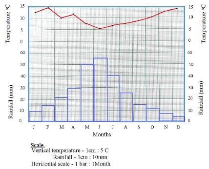
(i.) Represent temperature and rainfall distribution presented in a Climograph above in a table
(ii.) Calculate total annual rainfall for the given station
(iii.) Work out the annual mean temperature for station X
(iv.) With two reasons suggest the type of climate for station X above
5. (a) Give five importance of parallels
(b) Position of a place on a map can be located by using different methods. List down four methods of locating position on maps
6. (a) Carefully study the diagram below and then answer the questions below.
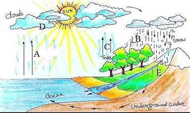
(i) What is the name of a diagram above
(ii) Name the processes indicated by letter A – E
(b) Water scarcity is still a challenge to most of developing countries like Tanzania, briefly describe four factors affecting water supply in Tanzania
7. The surface of the continents are not smooth, there are variety of landforms found on them. The altitude and slope give rise to different relief features.
(a) With examples, identify five relief features found on the surface of Tanzania.
(i) ______________________________________________________________________
(ii) _____________________________________________________________________
(iii) _____________________________________________________________________
(iv) ______________________________________________________________________
(v) ______________________________________________________________________
(b) What is the name given to the part of the earth’s surface that rise abruptly to a greater height above 300 meter from the surroundings level?
________________________________________________________________________
(c) Using the landforms named in part (b) above, determine its types and each type provide one example
(i) ______________________________________________________________________
(ii) _____________________________________________________________________
(iii) _____________________________________________________________________
(iv) ______________________________________________________________________
8. Carefully study the map of MALULUMO VILLAGE given below then answer the questions below.
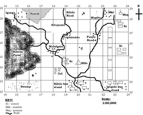
a) With one reason name the type of map shown above
b) If the length of the road in a map from Malulumo to Iganga is 12.5cm, calculate its actual ground distance.
c) By using the knowledge you have acquired in map work, explain how would you convert the map scale into statement scale.
d) Write down two natural and manmade features found on a map.
Natural features.
(i.) ……………………………………………………………………….……….
(ii.) ……………………………………………………………………………….
Manmade features.
(i.) ……………………………………………………………………………….
(ii.) ……………………………………………………………………………….
9. (a)A mountain is a part of the earth’s Surface that rises abruptly to a greater height usually above 300 metres from the surrounding level. By giving two examples from each, describe the four (4) major types of such mentioned physical feature. (b) Explain three applications of great circle
SECTION C (15 Marks)
10. The explain the role of solar energy in emancipation of women and children
FORM ONE GEOGRAPHY EXAM SERIES 191
FORM ONE GEOGRAPHY EXAM SERIES 191
PRESIDENT OFFICE REGIONAL ADMNISTRATION
AND LOCAL GOVERNMENT
SECONDARY EXAMINATION SERIES
COMPETENCE BASED ASSEMENT
GEOGRAPHY FORM ONE
MID TERM EXAMS-AUG/SEPT – 2024
TIME 2:30 HRS
INSTRUCTIONS
1. This paper consists of sections A, B and C with the total of ten (10) questions
2. Answer ALL questions
3. Section A and C carry fifteen (15) marks each and section B carries seventy (70) marks
4. All writing must be in blue or black ink
5. All writing must be written in the space provided
6. Cellullar phones, calculators and any unauthorized materials are not allowed in assessment room
7. Write your names at the top of every page.
SECTION A (15 marks)
Answer ALL questions
i. The low pressure zone of the equator is known as:-
- Latitude
- ITCZ
- Horse latitudes
- Polar front
ii. The instrument at the weather station which is painted white and is used for storing other weather instruments is known as a
- Barometer
- Wind vane
- Stevenson screen
- Rain gauge.
iii. Which object is found at the center of our solar system?
(A) The Moon
(B) Mars
(C) The Sun
D) An asteroid
iv. Besides the Sun, the largest object in our solar system is:
(A) Earth
(B) Neptune
(C) Jupiter
(D) The Asteroid Belt
v. Striping method is used in finding area for
- Irregular shapes
- Regular shapes
- Both regular and irregular shapes
- Plantation farms.
vi. The term Map refers to:-
- Ratio between the distance on the map and the actual distance on the ground.
- Lines connecting all points of equal height above sea level
- A representation of the earth or part of the earth on a flat surface such as paper or chalk board.
- A direction of one point from another expressed in degree of an angle from north clock wise.
vii. What and air currents do not move in straight lines due to spinning effect of the earth. The term used to describe this situation is?
- Defletion
- Reflection
- Direction
- Deflection
viii. The word "Geography" comes from two Greek words, meaning:
(A) Earth and Study
(B) Earth and Describe
(C) Land and Travel
(D) Land and Map
ix. Which one of the following is not a factor to consider while deciding the climate of a place?
- Prevailing winds
- Annual rainfall
- Distance from the ocean
- Annual range of temperature.
x. The following are factors affecting climate of a place. Which one is not?
- Latitude
- Vegetation
- Soil
- Longitude
2. Match the branch of geography in LIST A with the corresponding meaning in LIST B and write the correct answer on table given.
| LIST A | LIST B |
|
|
SECTION B
3. Answer the following questions per the given instructions:-
- Mention three kinds of rainfall
- ………………………………………………………………
- ………………………………………………………………
- ………………………………………………………………
- Name five weather elements in your locality
- ……………………………………………………………….
- ……………………………………………………………….
- ……………………………………………………………….
- ………………………………………………………………..
………………………………………………………………..
4. Differentiate between the following geographical terms.
a) Aphelion and perihelion
b) Longitude and Latitude.
c) Umbra and penumbra.
d) Lunar and solar eclipse.
5. Explain for (4) reasons to prove that the earth rotates on its own axis.
a) …………………………………………………………………
b) …………………………………………………………………
c) …………………………………………………………………
d) …………………………………………………………………
6.
- Mention three types of scales
- ………………………………………………………………..
- ………………………………………………………………..
- …………………………………………………………………
- Name three types of maps
- ………………………………………………………………….
- ………………………………………………………………….
- ………………………………………………………………….
- Identify three methods used to measure areas of irregular shapes in maps
- …………………………………………………………………….
- …………………………………………………………………….
(iii) …………………………………………………………………….
7. (a) Define revolution of the earth
(b) Mention the effects of earth revolution.
8.(a) Define the term Climate.
(b) What is the difference between climate and weather?
9.List four effects of rotation of the earth on its axis
SECTION C
10. Name and explain five types of mountains
FORM ONE GEOGRAPHY EXAM SERIES 182
FORM ONE GEOGRAPHY EXAM SERIES 182
THE PRESIDENT’S OFFICE
REGIONAL ADMINISTRATION AND LOCAL GOVERNMENT
GEOGRAPHY FORM ONE TERMINAL EXAMINATION
CODE 012
TIME: 2:30 HOURS
INSTRUCTIONS.
- This paper consists of section A, B and C with the total number of ten(10) questions
- Answer all questions in each section
- Section A carries (15) marks, section B (70) marks and section C carries (15) marks
- All writing must be in blue/black ink except drawing which must be in pencil
- Cellular phones and any unauthorized materials are not allowed in the assessment room.
SECTION A (15 Marks)
Answer all questions in this section
1. For each of the items (i) – (x) choose the correct answer from among the given alternatives and write its letter beside the item number in the answer sheet provided
(i) Which of the following is NOT considered a major domain of the Earth's environment?
A. Lithosphere
B. Biosphere
C. Atmosphere
D. Cryosphere
(ii) The study of geography helps us understand:
A. The spatial distribution and relationship of physical and human features on Earth
B. The history of the solar system
C. The chemical composition of stars
D. The evolution of dinosaurs
(iii) The largest planet in our solar system is:
A. Saturn
B. Jupiter
C. Earth
D. Mars
(iv) What causes Earth to experience day and night?
A. Revolution around the Sun
B. Rotation on its axis
C. Movement of the Moon
D. Changes in the amount of solar energy
(v) Which is an example of a renewable energy source derived from the Sun?
A. Solar power
B. Petroleum
C. Natural gas
D. Nuclear power
(vi) All of the following are major features of the Earth's surface EXCEPT:
A. Mountains
B. Rivers
C. Deserts
D. Asteroids
(vii) The world's largest ocean is the:
A. Atlantic Ocean
B. Indian Ocean
C. Arctic Ocean
D. Pacific Ocean
(viii) Which continent is home to the Sahara Desert, the world's largest hot desert?
A. North America
B. South America
C. Asia
D. Africa
(ix) What is the name for the underwater mountain ranges found on the ocean floor?
A. Mid-ocean ridges
B. Trenches
C. Abyssal plains
D. Reefs
(x) Which of the following planets is known for its distinctive rings?
A. Neptune
B. Jupiter
C. Uranus
D. Saturn
2. Match the ocean floor feature in Column A to its correct description in Column B.
| Column A | Column B |
|
|
SECTION B: 70 Marks
3.(a) What is an ocean?
(b) Name five oceans found on earth
4. (a) Explain how a block mountain is formed
(b) Name one example of each of the following;
- Block mountain
- Fold mountain
- Volcanic mountain
- Residual mountain
- A rift valley
5.(a) What is international date line? Explain why it is not straight
(b) Explain five importance of latitudes and longitudes
6. (a) differentiate between a solstice and equinox
(b) Give two dates in a year when equinox occurs
(c) Using a diagram explain how solar eclipse is formed
7. (a) What is revolution of the earth?
(b) Name four seasons of the year
(c) A part from seasons name any other three effects of revolution
8. (a) Name four outcomes of earth’s rotation
(b) List seven planets from the one closest to the sun to the furthest
9. (a) Define the term geography
(b) The sun gives us solar energy. Give six uses of solar energy
SECTION C. (15 Marks)
10. Our ancestors believed that the earth was flat. As an enlightened student discuss six proves that the earth is spherical.
FORM ONE GEOGRAPHY EXAM SERIES 169
FORM ONE GEOGRAPHY EXAM SERIES 169
PRESIDENT’S OFFICE, REGIONAL ADMINISTRATION AND LOCAL GOVERNMENT
SECONDARY EXAMINATION SERIES,
MID TERM ONE – MARCH-2024
GEOGRAPHY FORM ONE
TIME 2HOURS
INSTRUCTIONS.
- This paper consists of section A, B and C with the total of ten (10) questions.
- Answer all questions in each section.
- Section A carries 15 marks, section B 70marks and section C carries 15marks
- All writing must be in blue or black ink.
- All answer must be written in the space provided to you.
- All communication devices, calculators and any unauthorized materials are NOT allowed in the examination room.
- Write your examination number on every page of your answer sheet(s)
Section A. (30 MARKS)
- Choose the correct answer from alternative given;
- Which of the following planet is closest to the sun?
- Earth.
- Jupiter.
- Mars.
- Mercury.
- Neptune.
- Which of the following Planets is furthest from the sun?
- Neptune.
- Venus.
- Mars.
- Earth.
- Mercury.
- What is the position of the earth from the sun?
- Second.
- Third.
- Fourth.
- Last.
- The last but one.
- Which of the following bodies is the centre of the solar system?
- Sun.
- Earth.
- Moon.
- Meteor.
- Planet.
- Which of the following is not true about the uses of solar energy?
- Solar energy is used for heating homes.
- Solar energy is used for drying clothes and grains.
- Solar energy is used in heavy industries.
- Solar energy is used as source of light.
- Solar energy is used to drive carts.
- Which of the following statement is true regarding satellites?
- All satellites are bigger than the earth.
- All the planets have satellites.
- Some planets have satellites, some do not.
- The moon is a satellite that produces its own light.
- Saturn has no natural satellite.
- Which of the following is true regarding the earth?
- It is the third largest planet in the solar system.
- It is the only planet that is known to support life.
- It revolves around the sun once in every 364 days.
- It revolves in an orbit that crosses orbits of the planet.
- It has an average temperature of about 100°C.
- Which of the following is true regarding planets?
- All planets revolve around the sun.
- They take 364 days to complete one revolution.
- All planets revolve around the sun on the same orbit.
- The temperature of the planets increase with increasing distance from the sun.
- All planets rotate around the sun.
- Day and midnight are caused by
- Earth’s rotation.
- Earth’s revolution.
- Distance of the earth from the moon.
- Distance of the earth from the sun.
- Eclipse of the moon.
- Places on the East of the Greenwich experience sunrise before places on the West because the earth:
- Rotates from the east to west.
- Rotates from the west to the east.
- Revolves around the sun.
- Is very far from the sun.
- Is very close to the sun.
- Match each statement in Column A with its corresponding item in Column B
| Column A | Column B |
|
|
- (a) Mention four job opportunities that can be obtained after studying Geography.
(b) Mention any four activities that require geography knowledge and skills.
4. Describe the following terms;
- The planet
- The sun
- Orbit
- Solar system
- Solar energy
5.. (a) Differentiate between meteriotes and asteroids
(b) List four domestic uses of solar energy
6. Define the terms;
- Rotation of the earth
- Revolution of the earth
(b) What are the outcomes of rotation of the earth?
7. Describe the importance of latitudes and longitudes
8. (a) Give three evidence of earth’s rotation
(b) Explain the contribution of solar energy in liberation of women.
9. Tom and Mary were arguing, Tom insisting that the earth is flat. On the other hands Mary tried to pursued Tom that the earth is round. Using six points, help Mary pursued Tom that the earth is round.
10. The study of geography is a life-line to many students future. Elaborate.
FORM ONE GEOGRAPHY EXAM SERIES 164
FORM ONE GEOGRAPHY EXAM SERIES 164
PRESIDENT OFFICE REGIONAL ADMINISTRATION AND LOCAL GOVERNMENT
SECONDARY EXAMINATION SERIES
COMPETENCE BASED ASSESSMENT
013 GEOGRAPHY FORM ONE
ANNUAL EXAMINATION – 2023
Time: 2:30 Hours
Instructions
- This paper consists of sections A, B and C with a total of ten (10) questions.
- Answer all questions.
- Section A and C carry fifteen (15) marks each and section B caries seventy (70) marks
- All writing must be in blue or black ink
- All writing must be written in the space provided.
- Cellular phones, calculators and any unauthorized materials are not allowed in the assessment room.
SECTION A (15 MARKS)
1. For each of items (i) – (x) choose the correct answer from alternative given and write it against item given.
i. What type of rainfall occurs when warm moist wind from the Indian Ocean comes into contact with the cold air mass from land mass?
- Orographic rainfall
- Frontal rainfall
- Convectional rainfall
- Cyclonic rainfall
ii. John was told by his teacher that the earth makes one complete rotation every twenty four-hour. From which direction does it rotate?
- West to East
- South to North
- North to South
- East to west
iii. Anna and Asha were required to calculate of a road on a map in Kilometers provided that; the map scale was 1:50,000 and the distance measured on the map was 10cm. Which among the following was the actual distance presented by them?
- 10km
- 5km
- 15km
- 20km
iv. If the temperature for Dar-es-Salaam at the sea level is 30°C, what is the temperature for Moshi at 300M above the sea level?
- 31.2°C
- 28.2°C
- 30.2°C
- 32.2°C
v. Which of the following is an example of Residual mountain in Tanzania
- Mount Sekenke
- Mount Kilimanjaro
- Mount Ruwenzori
- Mount Meru
vi. A branch of geography that enable leaner to acquire practical skills that enhance their ability for interpreting both skills, this is called
- Physical geography
- Practical geography
- Human and economic geography
- Skills geography
vii. A business woman from Siberia who is found in Eastern part went to Alaska which is found in Western part, for her business trip. What will happen to her in concept of gain and losing the day?
- Gain a day
- Loses a day
- Gain and loses a day of the some time
- None of the above
viii. The five essential of the map are the one which make the map complete the essential which is used in measuring the distance in the map is known as
- Scale
- Key
- Compass
- Title
ix. The graph which shows both temperature and rainfall characteristics is called.
- Bar graph
- Climatorgraph
- Isograph
- Isobar
x. A collection of salt tolerant tree and scrubs grow on estuaries and deltas of tropical coastline is
- TropicalMansoon forest
- Mangrove forest
- Equatorial forest
- Deciduous forest
2. Match the type of Natural forest in LIST A with the corresponding description in LIST B by writing the letter of the correct response in the box below.
| LIST A | LIST B |
|
|
SECTION B: (70 Marks)
Answer all questions
3. (a)Amani was wondering to see the rain along the eastern slope of Mt. Kilimanjaro leaving the west with rain shadow effect
(i) Which type of rainfall on eastern side
(ii) With aid of diagram show type of rainfall experienced by Amani.
(b)Describe factors that determine climate of a place
4, (a) On any given map you can locate position of different things by using different methods. Identify the four methods which can be used to locate positions
(b)Convert 1:50,000 into statement scale
(c)Draw signs and symbols of the following
- Mountain
- Swamp
- School
- Railway
5. Study carefully the data recorded from major weather station from 4th January 2023 to 11st January 2023 and answer question that follow
| Day | Mon day | Tues day | Wednesday | Thursday | Friday | Saturday | Sunday |
| Temp C° | 19 | 20 | 20 | 21 | 19 | 21 | 20 |
| Rain (mm) | 35 | 47 | 40 | 43 | 27 | 41 | 39 |
- Calculate weekly average temp in centigrade
- Complete the weekly rainfall in millimeters
- Find temperature range with the week
- Which is the wettest day in a week? Why?
- What were the coldest days in a week? Why?
6. Juma and his friend were Watching news on Television on weather forecasting, that tomorrow Morogoro region will experience high temperature
- As a form one student help Juma explain why the forecast did happen as expected
- Short list four elements of weather
7. During holiday, Pendo travelled from Dar-es-Salaam to Mbeya but when she reached at Iringa she experienced different climate which differ from that of Dar-es-Salaam and Morogoro.
- Help Pendo identify five causes of climate variations
- Give five differences between climate and Weather
8. The earth is not flat but round. Justify this statement using six points
9. (a)Explain what will happen when
- The earth process between moon and the sun
- The moon passes between sun and Earth support using diagram.
(b)Identify four resultant effects of earth rotation
SECTION C (15 Marks)
10. (a) How does Tanzania benefit from solar Energy
(b)In which ways does society benefit from weather forecasting?
FORM ONE GEOGRAPHY EXAM SERIES 152
FORM ONE GEOGRAPHY EXAM SERIES 152
PRESIDENT'S OFFICE REGIONAL ADMINISTRATION
AND LOCAL GOVERNMENT
SECONDARY EXAMINATION SERIES
COMPETENCE BASED ASSESSMENT
GEOGRAPHY FORM ONE
MID TERM EXAMS-AUG – 2023
TIME 2:30 HRS
INSTRUCTIONS
1. This paper consists of sections A, B and C with the total of ten (10) questions
2. Answer ALL questions
3. Section A and C carry fifteen (15) marks each and section B carries seventy (70) marks
4. All writing must be in blue or black ink
5. All writing must be written in the space provided
6. Cellullar phones, calculators and any unauthorized materials are not allowed in assessment room
7. Write your names at the top of every page.
SECTION A (15 marks)
Answer ALL questions
1. Choose the correct answer from the following multiple choices
i. Drawing a map based on distribution of natural features in Tanzania. This activity is based on what branch of Geography?
a) Physical geography
b) Practical geography
c)Regional geography
d) Human and economic geography
Ii. Form one students were discussing about the chronological arrangement of planets in the solar system which among the following is the largest planet?
a) Jupiter b) Uranus
c) Saturn d) Pluto
iii. Why are the planets not colliding one another as they revolve the sun?
a) Because each planet has it own moon
b) All planets have satellites
c) Because each planet has it own path called orbirt
d) Because all planets revolve around the sun on the same orbit
iv. Last session in Geography club, Kamla and Rohan were studying about the Earth.
Which of the following is true regarding the Earth as they were discussed?
a) It is the third largest planet in the solar system
b) It is the only planet that is known to support life.
c) It has average temperature that crosses the orbits of other planets
d) It revolve around the sun once in every 364 days
v. When the moon shadow is cast over the earth’s the phenomena is called:-
a) Lunar eclipse b) Solar eclipse
c) Equinox d) Summer solistice
vi. Which of the following is evidence that the Earth is a spherical ?
a) The ship comes from far away
b) The ship sails on the surface of a round Earth
c) The Earth revolves around the sun
d) The ship’s visibility in the ocean changes with distance
vii. Equal length of day and night when the sun is overhead at the equator is known as :-
a) Solstice b) Aphelion
c) Cars d) Periphelion
viii. From the following pairs of mountains which one represent fold mountains:
a) Himalaya and Usambara
b) Atlas and Alps
c) Uluguru and Usambara
d) Kilimanjaro and Vesuvius
ix. The decrease of temperature with the increase of altitude is known as:
a) Temperature inversion b) latitudional
c) Isotherms d) Lapse rate
x. If the minimum and maximum temperature recorded in Dar-es-salaam on May 23rd 2019 were 23.5? and 32.5? respectively. Calculate the mean daily temperature of Dar-es-salaam.
a) 56? b) 9.0?
c) -9.0? d) 28?
| i | ii | iii | iv | v | vi | vii | viii | ix | x |
|
|
|
|
|
|
|
|
|
|
|
2. Match each term from List B with correct meaning in List A
| LIST A | LIST B |
| ||||
| i) The planet called boiling planet due to its closeness to the sun ii) The only planet which support the life iii) The hottest planet which has high amount of greenhouse gases in its atmosphere. iv) Its atmosphere is mainly composed of carbon dioxide and has two natural v)The planet that has a ring system which act as its distinctive feature | a) Jupiter b) Saturn c)Mars d)Earth e) Mercury f)Venus g) Uranus |
| ||||
| i | ii | iii | iv | v | ||
|
|
|
|
|
| ||
|
|
|
|
|
|
|
|
SECTION B (70 marks)
Answer ALL questions
3. a i) An eclipse is a total or partial obstruction of light from the sun by either the earth or the moon. How does it occurs?
____________________________________________________________________________________ ____________________________________________________________________________________
ii) What type of eclipse will occur when the moon is between the Sun and Earth and its shadow fails on the Earth’s surface?
____________________________________________________________________________________ ____________________________________________________________________________________
b) Is it possible for a solar or lunar eclipse to happen every month? Explain your answer. ____________________________________________________________________________________ ____________________________________________________________________________________ ____________________________________________________________________________________
____________________________________________________________________________________
4. As a Geographer suppose that you have been invited by the villagers of
Songambele village to teach them about the major features found on the Earth’s surface.
a) Identify four features that may be found in Songambele village.
i) ___________________________________________________________________________________
ii) __________________________________________________________________________________
iii) __________________________________________________________________________________
iv) _________________________________________________________________________________
b) Mention four types of the feature of the Earth’s surface that rises abruptly to a graeter height usually above 300 meters from a surrounding level.
i) ___________________________________________________________________________________
ii) __________________________________________________________________________________
iii) __________________________________________________________________________________
iv) _________________________________________________________________________________
c) Identify two benefits of that features mentioned above in (a).
i) ___________________________________________________________________________________
ii) __________________________________________________________________________________
5. a) In Mtakuja villages people have been engaged into different activities. What are the five possible human activities that may be conducted in Mtakuja village.
i) ___________________________________________________________________________________
ii) __________________________________________________________________________________
iii) __________________________________________________________________________________ iv)__________________________________________________________________________________
v) __________________________________________________________________________________
6(a) Asiatu and Sweke wanted to drop Geography subject because they think that it is useless. As a Geographer tell them the benefit of studying Geography.
i) ___________________________________________________________________________________
ii) __________________________________________________________________________________ iii)__________________________________________________________________________________ iv)__________________________________________________________________________________ v)__________________________________________________________________________________
d) Geography describes how human beings interact with the environment. Identify two components of environment and explain each component
i)___________________________________________________________________________________ ____________________________________________________________________________________ ii)___________________________________________________________________________________ ____________________________________________________________________________________
d)(i) Geography as a subject has three main branches, mention them
i)___________________________________________________________________________________ ii)___________________________________________________________________________________
iii)__________________________________________________________________________________
7. a) Briefly explain on the meaning of the term Weather station
____________________________________________________________________________________ ____________________________________________________________________________________ ____________________________________________________________________________________ ____________________________________________________________________________________
b) Outline four conditions necessary for establishing weather station.
i)___________________________________________________________________________________ ____________________________________________________________________________________
ii)___________________________________________________________________________________
____________________________________________________________________________________ iii)__________________________________________________________________________________ ____________________________________________________________________________________
iv) _________________________________________________________________________________ ____________________________________________________________________________________
c) Amount of sunshine in the sky is determined by the presence or absence clouds.
Outline the importance of sun shine (five points)
i) ___________________________________________________________________________________ ii)___________________________________________________________________________________
iii) __________________________________________________________________________________
iv) _________________________________________________________________________________
v) __________________________________________________________________________________
8. a) Both latitude and longitudes are used to locate position on a map. Identify their differences
____________________________________________________________________________________ ____________________________________________________________________________________ ____________________________________________________________________________________
b) Mention three importance of latitudes and longitudes
i) __________________________________________________________________________________
ii) __________________________________________________________________________________
iii) __________________________________________________________________________________
c)What is the longitude of Lindi whose local time is 8:24pm when the local time of Montevideo (Uruguay) 56°W is 2:00pm?
____________________________________________________________________________________ ____________________________________________________________________________________ ____________________________________________________________________________________ ____________________________________________________________________________________ ____________________________________________________________________________________ ____________________________________________________________________________________ ____________________________________________________________________________________ ____________________________________________________________________________________ ____________________________________________________________________________________ ____________________________________________________________________________________
____________________________________________________________________________________
9.a) A map is good if it contain all the essential of map. Identify five essentials of a good map and their functions.
i) __________________________________________________________________________________ ii) __________________________________________________________________________________ iii) __________________________________________________________________________________ iv) __________________________________________________________________________________ v) __________________________________________________________________________________
b) Identify procedures used to locate position on a map by using a compass bearing
i)___________________________________________________________________________________ ii)___________________________________________________________________________________
iii) __________________________________________________________________________________
c)Different features on a map may appear either in regular or irregular shapes. Mention three methods of determining areas of irregular shapes on a map.
i) __________________________________________________________________________________
ii) __________________________________________________________________________________
iii) __________________________________________________________________________________ SECTION C (15 MARKS)
Answer question number ten (10)
10. Carefully study the climatic data for station X and then answer the given questions
| Months | J | F | M | A | M | J | J | A | S | O | N | D |
| Temp ? | 23 | 24 | 24 | 24 | 24 | 24 | 26 | 26 | 27 | 26 | 26 | 24 |
| Rainfall mm | 338 | 200 | 433 | 355 | 275 | 230 | 160 | 70 | 50 | 25 | 15 | 230 |
a) Calculate the annual range of temperature
____________________________________________________________________________________
____________________________________________________________________________________ ____________________________________________________________________________________
b) Calculate the total rainfall
____________________________________________________________________________________
____________________________________________________________________________________ ____________________________________________________________________________________
c)With two evidences, suggest the type of climate for station X
____________________________________________________________________________________
____________________________________________________________________________________
____________________________________________________________________________________
c) What are the major economic activities that conducted in that area.
I) __________________________________________________________________________________
II) __________________________________________________________________________________
III) _________________________________________________________________________________
FORM ONE GEOGRAPHY EXAM SERIES 145
FORM ONE GEOGRAPHY EXAM SERIES 145
PRESIDENT OFFICE REGIONAL ADMNISTRATION
AND LOCAL GOVERNMENT
SECONDARY EXAMINATION SERIES
COMPETENCE BASED ASSEMENT
GEOGRAPHY FORM ONE
TERMINAL EXAMS-MAY – 2023
013
Time: 2:30 Hours
Instructions
- This paper consists of sections A, B and C with a total of ten (10) questions.
- Answer all questions.
- Section A and C carry fifteen (15) marks each and section B caries seventy (70) marks
- All writing must be in blue or black ink
- All writing must be written in the space provided.
- Cellular phones, calculators and any unauthorized materials are not allowed in the assessment room.
SECTION A (15 MARKS)
- For items (i) – (x) Choose the correct answer from alternative given and write its leer on spaces provided.
- Geography helps the learner to acquire the following things in his/her life except.
- Knowledge and skills
- Understanding their environment
- Guessing future events.
- Conserve their environment.
- A branch of human – economic Geography that deals with the study of human population is called.
- Biogeography
- Demography
- Geography
- Geology.
- Dormant volcanic mountains are those which;
- Have never experienced eruptions
- Have erupted once but are nolonger active
- Continue to erupt occassionaly
- Erupt only then there is an earth quake.
- A raised part of an ocean is called;
- A ridge
- Ocean deeps
- Continental shelf
- Deep sea plains
- The outermost layer of the earth is called;
- The mantle
- The crust
- The sial
- Sima.
- Which of the following is an example of an extinct volcano?
- Mt. Elgon
- Mt. longonot
- Black forest mountains
- Mt. Sinai.
- Movement of the earth around the Sun is referred to as__________
- Evolution
- Rotation
- Motion
- Revolution.
- Which of the following groups are features of the Ocean floor?
- Ridge, basin, plateau and water fall.
- Continental shelf, basin and water fall
- Ocean ridge, continental shelf and continental slope
- Horst, plain, basin and volcano
- Hills, Mountains, Plateaus, plains and valleys make up
- Continent of Africa.
- Relief of the earth’s surface
- Lowland
- Landscape evolution
- A body of land completely surrounded by water is referred to as the
- Gulf
- Strait
- Island
- Cape
- Match the items from list A with those in list B.
| LIST A | LIST B |
| (i) Survey (ii) Climatology (iii) Geography (iv) Practical geography (v) Geomorphology
|
|
SECTION B (70 Marks)
- Study the following climatic table of station "P" and answer the questions that follow

(a) Calculate annual mean temperature (b)Find annual range rainfall
(c)Find total annual rainfall of station P (d) Suggest the type of climate of station "P"
(e) mention any five(5) crops that can be grown in station P
4. Mr Kombo decided to measure Sindeni road ,he got 20cm long on the map, what about actual distance of Sindeni road while scale of the map is 1:200000?
- a. Describe the shape of the Earth
b. There is enough evidence to show that the Earth is Spherical. Give five (5) evidences that the Earth is spherical.
6. (a) List down five seas in the world
(i) ………………………………………………………
(ii) ………………………………………………………
(iii) ………………………………………………………
(iv) ……………………………………………………..
(v) …………………………………………………….
(b) Name five lakes in East Africa
(i) ……………………………………………………………..
(ii) ……………………………………………………………..
(iii) ……………………………………………………………..
(iv) ……………………………………………………………..
(v) ……………………………………………………………...
7.Answer the following questions per the given instructions:-
a) Mention three kinds of rainfall
(i) ………………………………………………………………
(ii) ………………………………………………………………
(iii) ………………………………………………………………
b) Name five weather elements in your locality
(i) ……………………………………………………………….
(ii) ……………………………………………………………….
(iii) ……………………………………………………………….
(iv) ………………………………………………………………..
(v) ………………………………………………………………..
8.I Differentiate between the following geographical terms.
a) Aphelion and perihelion
b) Longitude and Latitude.
c) Umbra and penumbra.
d) Lunar and solar eclipse.
II. (a) Name five elements of the solar system.
(i) …………………………………………………………………………..
(ii) …………………………………………………………………………..
(iii) ………………………………………………………………………….
(iv) ………………………………………………………………………….
(v) ………………………………………………………………………….
SECTION C (15 Marks)
Choose any one question.
9. Discuss the significance of studying geography by secondary school students
10. Describe the importance of the components of the solar system
FORM ONE GEOGRAPHY EXAM SERIES 131
FORM ONE GEOGRAPHY EXAM SERIES 131
PRESIDENT OFFICE REGIONAL ADMINISTRATION AND LOCAL GOVERNMENT
SECONDARY EXAMINATION SERIES
COMPETENCE BASED ASSESSMENT
013 GEOGRAPHY FORM ONE
MID-TERM EXAMS-MARCH – 2023
Time: 2:30 Hours
Instructions
- This paper consists of sections A, B and C with a total of ten (10) questions.
- Answer all questions.
- Section A and C carry fifteen (15) marks each and section B caries seventy (70) marks
- All writing must be in blue or black ink
- All writing must be written in the space provided.
- Cellular phones, calculators and any unauthorized materials are not allowed in the assessment room.
SECTION A (15 MARKS)
1. For items (i) – (x) Choose the correct answer from alternative given and write its leer on spaces provided.
- John was told by his teacher that the earth makes one complete rotation every twenty four hour from which direction does it rotate?
- West
- South
- North
- East
- A form one student was studying about continents he read that one of the continents was crossed by both tropics, tropk of cancer and tropic of Capricorn which continent was that?
- Africa
- North America
- Europe
- Asia
- Some people were transporting water from Nyumba ya Mungu to Mwanga town. An activity undertaken by those people may be studied under which branch of geography?
- Physical geography
- Practical geography
- Human geography
- Trans – human geography
- A Branch of geography dealing with field study statistics mapping and surverying is called
- Physical Geography
- Human and Economic geography
- Practical geography
- Environment geography
- When the earth is at its aphelion in early July the distance from the sim in about?
- 500,000,000km
- 5,500,000km
- 4,800,000km
- 15,000,000km
- Amount of humidity that exists in air is measured by instrument called:
- Barometer
- Hygrometer
- Hydrometer
- Agrometer
- Map of school compound or small village in drawn using
- Large scale
- Small scale
- Medium scale
- Secondary section of the scale
- Which sequence of the following processes is necessary for formation of rainfall?
- Condensation, cooling and evaporation
- Evaporation, cooling and condensation
- Evaporation, sedimentation and cooling
- Evaporation, condensation and cooling
- What is compass bearing of WNW?
- 270°
- 337°
- 315°
- 327°
- What name is given to section of Asteroid between mars and Jupiter?
- Planetoids
- Kuiper belt
- Bolides
- Asteroid Belt
2. Match each item in LIST A with responses in LIST B by writing the letter of correct response below the corresponding item number in table provided.
| LIST A | LIST B |
|
|
SECTION B (70 marks)
Answer all questions
3. Direction and Bearing can be used to determine position of a play ground in your school map.
- Mention the four main direction on the map
- Using a well labeled diagram, show the eight compass directions and bearings you would use to show location of any feature on that map.
4. (a)Define Geography
(b)Mention three branches of geography
(c) Give reasons why geography in taught in secondary schools.
5. (a)name and explain three layers of the earth
(b)Briefly explain composition of atmosphere
6. (a)Give two examples of ach of the following
- Fold mountains
- Volcanic mountain
- Fold mountains
(b) Explain how volcanic mountains are formed
7. (a)Explain uses of water in daily life
(b)Give meaning of terms below;
- A Peninsula
- A ridge
8. (a)What are satellites?
(b)Name five Natural satellites
9. (a)Define solar system
(b)Give importance of Components of solar system
SECTION C (15 Marks)
Answer Question ten (10)
10. Form one students were taught by their Geography teacher that African continent has major relief features? Giving two examples for each describe the five major relief features the teacher taught students.
FORM ONE GEOGRAPHY EXAM SERIES 118
FORM ONE GEOGRAPHY EXAM SERIES 118
THE PRESIDENT’S OFFICE MINISTRY OF EDUCATION, REGIONAL ADMINISTRATION AND LOCAL GOVERNMENT
COMPETENCY BASED SECONDARY EXAMINATION SERIES
GEOGRAPHYFORM ONE
TIME: 2 HOURS NOVEMBER 2022
Instructions
1. This paper consists of sections A, B and C.
2. Answer all questions in sections A and B and only one (1) question in section C.
3. Section A carries fifteen (15) marks, section B carries seventy (70) marks and section C carries fifteen (15) marks.
4. All answers must be written in the spaces provided.
5. Cellular phones, calculator and unauthorized materials are not allowed in the examination room.
6. Write your Examination Number on the top right on every page.
SECTION A (15 Marks)
Answer allquestions in this section
1. For each of the following items (i) – (x), choose the correct answer from among the given alternatives and write its letter in the box provided.
- The students learned about lines measured in degrees, minutes and seconds of a point on the earth’s surface north or south of the equator. What is the common name of these lines?
A. Great circle
B. Latitude
C. Longitude
D. Greenwich.
- Mr. Chande went to Brazil located 55oW to watch a live football match between Brazil and Germany, a Brazil player scored a goal for his team at 4:00 pm. What will be a time at Mwanza in Tanzania located at 35oE?
A. 4:00 pm
B. 6:40 pm
C. 10:40 pm
D. 10:00 pm.
- The tourists enjoyed the temperature of Dar es Salaam which was 30oC at the sea level. They also planned to travel from Dar es Salaam to Kilimanjaro. Which is 2500 meters above the sea level. What will be the temperature experienced by the tourists in Kilimanjaro?
A. 5oC
B. 0oC
C. 7oC
D. 90oC.
- Mr. Kaula constructed map of his village without indicating the scale of that map. What effect will be faced by the user of such map?
A. Failure to identify village boundary
B. Failure to identify the actual size of the village
C. Ability to identify the actual size of the village
D. The content of the map will not be understood.
- Form one student visited his grandmother at the village, he heard his grandmother saying it may rain today due to sound of frog. That way of prediction weather is called:
A. Modern weather forecast
B. Regional weather forecast
C. Traditional weather forecast
D. Grandmother watched TV.
- The periodic rise and fall in the level of water in the ocean is known as:
A. Tides B. Waves C. Ocean currents D. Wind
- Amina moves to the west and crosses the International Date Line. What happens with regard to time?
A. No time is gained or lost B. One whole day is lost
C One whole day is gained D. One whole day is repeated
- A scale of 4cm representing 18km on the ground, will be represented by representative fraction (R.F) scale as
A. 1:900,000 B. 1:1,800,000 C. 1:450,000 D. 2:800,000
- A channel diverging from Main River and flowing into the sea or lake by a separate mouth is called.
A. Distributary B. Stream C. Tributary D. River basin
- The winds which blow from the sea to the land is called; a) Wind breeze b) Sea breeze c) Land breeze d) Ocean currents
2. Match the description of the features of the ocean floor in LIST A with the corresponding features in LIST B by writing the letter of the correct response below:
SECTION B (70 Marks)
Answer all questions in this section.
3. In each of the following items (i – x), write True if the statement is correct or False if the statement is not incorrect.
i. Global warming is a decrease in temperature on the earth surface
___________
ii. Reforestation is a process of cutting down all trees without replacement _______________
iii. Mozambique current causes rainfall along the eastern coast of Tanzania
_______________
iv. Lapse rate is the gradual decrease or increase in temperature as altitude increases or decreases ________________
v. Hydrological cycle is a continuous circulation of water from earth’s surface to the atmosphere ______________
vi. Dry bulb and wet bulb thermometers are used when measuring humidity, when the air is not saturated the two thermometers show the different readings and when the air is saturated the two thermometers show same readings ______________
vii. Wind is air in motion from low pressure to high pressure area
_____________
viii. A longitudes is an angular distance measured in degree East and South of the equator_________________
ix. The area from which river system collects its rain water is called catchment area______________
x. People living in Dar es Salaam see the sunrise earlier than in Kigoma Because people in Kigoma sleeps longer ______________
4. Study carefully a data recorded from Major weather station January to December 2020 and answers the question below.
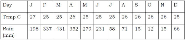
i. Calculate the annual average temperatures
ii. Compute the annual rainfall
iii. What type of climate is this?
iv. Give two reasons to support the choice of the climate mentioned in (iii) above
v. In which part of Africa this climate is found?
5. (a). Convert the following scales according to the instructions given
i. “One centimeter on the map represents half kilometer on the ground” Convert this scale into Representative fraction (R.F) scale.
ii. 1:150,000. Convert into statement scale.
b). State the directions of the following bearing.
i. 2700 __________________________________________________________
ii. 1350___________________________________________________________
c). How can we locate positions on map?
i. _______________________________________________________________
ii. _______________________________________________________________
iii. _______________________________________________________________
iv. _______________________________________________________________
6. Form one students at Buhongwa Secondary School visited the weather station at Mwalimu Nyerere International Airport, they saw various instruments and devices. One device was white wooden box, a box had louvers all the sides, and double boarded roof. It mounted on a stand 121cm above the ground, it was the first time for form one students to see that device.
(a) As a form one student identify that device:
(b) Why the device was made like that
(c) Name two (2) instruments kept in it
(i)
(ii)
(d) Mention two (2) uses of the instruments mentioned above.
(e) List two (2) importance of that station in our daily life
(i) __________________________________________________________________
(ii) __________________________________________________________________
7. (a) Madam Bahati is a geography teacher at Karibuni Secondary School, she has taught
her students on branches of that subject. As a form two student describe to us what she said on branches of that subject.
(b) From (a) above, what are the likely four (4) significance of teaching that subject in our schools
8. Carefully study the map given and answer the following questions:
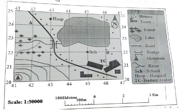
(a) Identify two (2) ways that can be used to calculate area of lake on mapped area
(i) ___________________________________________________________________
(ii) ___________________________________________________________________
(b) Use one of the method mentioned above to calculate area covered by lake
_________________________________________________________________________________
(c) Identify features or things shown at grid references
(i) 450220 = _______________________________________________________________
(ii) 465245 = _______________________________________________________________
(d) Identify elements of a good map that has been shown in a given map
(i) _______________________________________________________________
(ii) _______________________________________________________________
(iii) _______________________________________________________________
(e) State the functions of each element mentioned in (d) above
(i) _______________________________________________________________
(ii) _______________________________________________________________
(iii) _______________________________________________________________
(iv) _______________________________________________________________
9.(a) “Geography” can be defined as the study of the distribution and interrelationship of phenomena in relation to the earth’s surface. Briefly explain how geography relates with:
(i) Biology
(ii) Commerce
(b) Explain the economic importance of studying geography:
SECTION C (15 Marks)
10. Mwajuma and Asha are the students at Maweni Secondary School. One day they were looking pictures in a certain book and met with a good picture showing how the earth looks like. After looking at that picture Asha didn’t want to believe that the earth appears in that way. As a form two student give six (6) facts to support the shape of that picture observed by them.
FORM ONE GEOGRAPHY EXAM SERIES 112
FORM ONE GEOGRAPHY EXAM SERIES 112
THE PRESIDENT’S OFFICE
REGIONAL ADMINISTRATIVE AND LOCAL GOVERNMENT
FORM ONE EXAMINATIONS SEPTEMBER 2022
GEOGRAPHY
TIME: 2:30 Hours
![]()
Instructions
- This paper consists of section A, B and C with a total often (10) questions.
- Answer all questions in section A and B and section C.
- All writing must be in blue of black ink.
- All answers must be written in the space provided.
- Cellular phones, calculator and any unauthorized materials are not allowed in the examination room.
- Write your examination number at the top right corner of every page.
SECTION A (15 MARKS)
Answer all questions in this section.
1. For each of the items (i) — (x), choose the correct answer from among the given alternative and write its letter in the box provided.
- The Earth's shape is flattered sphere which is called;
- Geodic
- Globe
- Galaxy
- Spheroid
- Cyclic
- Mr Maurice and his colleagues enjoyed the temperature of Mtwara which was 32°C at sea level.
They had a plan to travel to visit Babati for their vacation which is 1500m above the sea level. What will be the temperature they expect to experience during their visit in Babati?
- 23°C
- 41°C
- 0.6°C
- 9 °C
- 20°C
- Which of the following planets is closest to the sun?
- Earth
- Jupiter
- mars
- Mercury
- Neptune
- when the moon’s shadow casts over the earth’s surface the phenomenon is known as
- Lunar eclipse
- Solar eclipse
- Equinoxes
- Summer solstice
- Winter solstice
- The Earth have different evidences that proves that the Earth is spherical. What do you think that this is one among those evidences?
- The four seasons
- The lunar eclipse
- The revolution of the Earth
- The Earth rotation
- The eclipse of the sun
- If the scale of a map is 1: 50,000 what will be the actual ground distance of a river with 18cm on a map?
- 9km
- 2km
- 18000km
- 4Km
- 900,000 km
- If the temperature at 950 metres is 240 C What is the temperature of Kilimanjaro 5895 metres above the sea level?
- 10.240 C
- 340 C
- 5.670 C
- 18.50 C
- 320 C
- The following are the element of weather
- Soils, clouds, dew, humidity, rainfall
- Pressure, clouds, sunshine, humidity, winds
- Fog, barometer, humidity, pressure, air mass
- Pressure, humidity, soil, fog, rainfall
- Clouds, sunshine, pressure, humidity, thermometer
- Assume you have given a task to identify the proper arrangement of the first five planets of the solar system according to the distance from the sun starting with the nearest planet. Which one of the following set will be the best set of arrangement of the first five planets of the solar system?
- Mercury, Earth, Venus, Saturn, and Mars
- Mercury, Venus, Earth, Mars and Jupiter
- Venus, Mercury, Mars, earth and Venus
- Mars, Earth, Mercury, Jupiter and Venus
- Mercury, Jupiter, Earth, Venus and Uranus
- Taifa Stars scored a goal against Malawi in Town Y 150E at 4:00 pm. At what time will commentator at Town X 630W will communicate a goal?
- 4:47 pm
- 10:48 am
- 11:12 am
- 1:48 pm
- 6:12 pm
2. Match the descriptions of bodies in the solar system in List A with the correct solar system body in List B by writing the letter of the correct response below the corresponding item number in the table provided.
| List A | List B |
|
|
SECTION B (70 MARKS)
Answer All Questions from this section
3. The students were watching a video program showing the earth's surface in Tanzania which was irregular. Difference in altitudes and slope give rise to different features and human activities observed in the video program.
(a) Outline five possible features observed by the students.
(b) By giving an example, mention major types of water bodies observed.
(c) Give an example of the main natural basin on the earth's surface observed by the students in the video program
(d) Name four possible types of a large and elevated part of the earth's surface that rise from greater height the students observed.
4. (a) Giving one example, briefly explain four main categories of mountain.
(i) …………… …………… …………… ……………
(ii) ……………… ……………… ………………
(iii) …………… ……………… ……………… ………………
(iv) ……………… ……………… ……………… ………………
(b) (i) Briefly explain the formation of rift valleys.
(ii) List five rift valley lakes in East Africa.
5. Study the sketch map provided and answer the questions that follow:
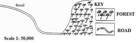
- Name the type of scale which has been used to represent this map.
- Mention three ways which can be used to measure the distance of the road in the sketch map.
- Briefly describe three important basic components of a map.
- Convert the given scale into a statement.
- Mention three methods which can be used to calculate the area of the forest shown on the sketched map.
6.(a) Outline five evidences to verify that the Earth is spherical.
![]() (b) Briefly describe the following features of the continents
(b) Briefly describe the following features of the continents
(i)Basin
(ii)Plateau
(iii)Valley
7. (a) Outline four ways of determining direction of a place on a map.
(b) List four features of the Representative Fraction (RF) scale.
(c) Suggest two ways of measuring areas with irregular shapes.
8. (a) What are the values of scale to the map users? Gives three
- Which methods can be used to locate position of a place on the map? Mention four.
- The distance of the road from Ifakara to Mang’ula is 38 cm. convert the distance in kilometer if the scale used is 1:50000.
- Why do you study maps? Give two reasons
- A large scale, medium scale and small scale maps all are the types of map scale.
With examples explain how they are distinguished by one to another. Give two reasons.
9. (a) Distinguish the following terms:
- Solar system and solar energy
- Raw materials and manufacturing industries
- Map and scale of a map
- Plateau and mountain
(b)
- Define lunar eclipse.
- Draw a well labelled diagram to show lunar eclipse.
SECTION B (15 MARKS)
Answer Question 10
10. (a) Carefully study the climatic data given for station X and then answer the questions that follow:
| Month | J | F | M | A | M | J | J | A | S | O | N | D |
| Temp °C | 30 | 30 | 30 | 31 | 32 | 38 | 37 | 37 | 35 | 34 | 31 | 30 |
| RAINFALL (mm) | 10 | 20 | 26 | 15 | 8 | 0 | 0 | 0 | 12 | 18 | 15 | 10 |
(i) Calculate the annual mean of temperature.
(ii) Determine the annual rainfall.
(iii) Calculate the mean range of temperature.
(iv) What type of climate does station X experience? Give reasons.
(v) Suggest the hemisphere in which station X is located.
(b) (i) Define:
a map
a scale
(ii) List down four essentials of a map.
(iii) In station P on a map, an area covered by thick forest was found to be 12 full squares and 26 half squares. Calculate the area of the thick forest in square kilometres.
(iv) If the map distance of Ruvu river is 29 centimetres, calculate actual distance of Ruvu river in kilometres given that the map scale is 1:25,000.
(v) Change the scale 1:25,000 into a statement scale.
FORM ONE GEOGRAPHY EXAM SERIES 102
FORM ONE GEOGRAPHY EXAM SERIES 102
THE PRESIDENT’S OFFICE
MINISTRY OF EDUCATION, REGIONAL ADMINISTRATION AND LOCAL GOVERNMENT
COMPETENCE BASED SECONDARY EXAMINATION SERIES
TERMINAL EXAMINATION
FORM ONE
GEOGRAPHY
013
TIME: 2:30 HOURS May, 2022
![]()
Instructions
1. This paper consists of sections A, B and C.
2. Answer all questions from sections A and B and any two (2) questions from section C.
3. Section A carries twenty five (25) marks, section B forty five (45) marks and section C carries thirty (30) marks.
4. All answers must be written in the spaces provided.
5. All writings must be in blue or black ink except for drawings which must be in pencil.
6. All communication devices, calculators and any unauthorized materials are not allowed in the Examination Room.
7. Write Your Examination Number on the top right of every page.
1. Each of the items (i) - (x), choose the correct answer from the given alternatives and write its letter in the space provided.
- The term Geography refers to:
- Describing of the Earth
- Geo and Graphien
- The study of man and his surroundings
- All of the above.
- Geomorphology is regarded as;
- The study of soil science
- The study of Geology
- The study of physical features
- The study of flora and fauna.
- Geography is sub – divided into;
- Practical, Human, Economic.
- Physical, Practical, Human
- Human – economic, practical and physical.
- Practical, Survey, Statistics.
- Agriculture, mining, lumbering can be studied in:
- Physical Geography.
- Human and economic Geography.
- Plant Geography.
- Practical and physical Geography.
- ocean currents are set in motion by;
- Differences in temperature of water in the ocean
- The earth rotation on its axis
- Land materials blown into the ocean by wind
- Prevailing wind that blows over the ocean
- Gravitational force
- The largest ocean on earth is;
- Indian ocean
- Pacific ocean
- Atlantic ocean
- Meditererian sea
- Red sea
- Which of the following statement are correct?
- Ocean water has a uniform temperature from bottom to top.
- The surface temperature of the ocean decreases polar wards
- Ocean water in the tropics is warmer on the surface than in its bottom.
- In the polar regions, ocean water temperature is warmer at the bottom than it is at the surface
- The Central body of the solar system is?
- The planet
- The Sun
- The Moon
- The Earth
- The spinning of the earth on its own axis is known as:-
- Rotation
- Revolution
- Day and night
- Distance
- A ship moves to the West and cross the International data line. What happens with regard to time gained or lost?
- No time is gained or lost
- One whole day is lost
- One whole day is gained
- One whole day is repeated
2. Match the descriptions of bodies in the solar system in List A with the correct solar system body in List B by writing the letter of the correct response below the corresponding item number in the table provided.
| List A | List B |
|
|
3. In each of the items (i) - (x), write TRUE if the statements correct or FALSE if the statement is not correct in the black space provided.
- Lunar eclipses prove that the earth is spherical in shape
- Precipitation refers to the deposition of moisture and air from the atmosphere on the earth's surface
- Solar energy is the arrangement of the planets and solid objects in relation to the position from the sun
- Crust is the inner most part of the earth……………………
- The continent that is crossed by both tropics of Cancer and Capricorn is Africa .:........
- Steroids are solid heavenly bodies revolving around the sun mostly between Mars and Jupiter ......
- The use of solar energy minimizes environmental degradation ..........
- Equinoxes means equal day and night hours at all latitudes ........„
- An eclipse is described as partial when only a part of heavenly body is obscured .........
- Circumnavigation of the earth is not among the evidence to prove that the earth is spherical......
SECTION B (45 Marks)
Answer all questions in this section.
4. (a) Differentiate between a continent and an ocean
(b) Name the continents of the earth
5 .(a) Briefly explain the following;
i) A plain
ii)Plateaus
(b) Diffentiate between fold mountains, block mountains and volcanic.
6.(a) Give two examples, of each of the following;
i. Fold mountains
ii. Volcanic mountains
iii. Fold mountains.
(b) Explain how volcanic mountains are formed.
SECTION C (30 Marks)
Answer two (2) questions from this section.
7. (a) Outline uses of water in daily life
(b) Give the meaning of the following terms;
i) A cape
ii) A peninsula
iii) A ridge
8.(a) Outline five evidences to verify that the Earth is spherical.
(b) Differentiate the following terms:
![]() (i) Meteors and satellites
(i) Meteors and satellites
(ii) Sea and lake
9.(a) Mention five features of the ocean floor.
(b) Name the five largest oceans in the world.
(c) Mention five largest lakes in the world.
(d) Differentiate the following terms:
(i)Temperature and humidity
(ii)Minimum and maximum thermometer
(iii) Pressure and wind
10. (b) Describe the importance of the sun
(b) Write the eight planets which revolve the sun;
FORM ONE GEOGRAPHY EXAM SERIES 92
FORM ONE GEOGRAPHY EXAM SERIES 92
THE PRESIDENT'S OFFICE
MINISTRY OF REGIONAL GOVERNMENT AND LOCAL GOVERNMENT
MID TERM-1 EXAMINATION
GEOGRAPHY FORM-1
2022- MARCH/APRIL
APRIL 2022
TIME: 2.00 HOURS
INSTRUCTIONS:
!. This paper consists of sections A, B and C.
2. Answer all the questions in all the sections.
SECTION A (25 MARKS)
- For each of items (i) – (x) choose the most correct answer from among the given alternatives and write its letter in the box provided. Draw a similar box on your answer sheet for your answers.
- Which one of the following statements about solar system is not correct?
- The solar system comprises of the sun, planets, asteroids, comets and dust.
- The planet, the sun and other bodies revolve around the solar system.
- The sun is the central body of the solar system generating its own light and heat.
- Which of the following statement is true regarding satellite?
- All satellites are bigger than the earth.
- All planets have satellites.
- Some planets have satellites some do not.
- Which of the following is not true about the uses of solar energy?
- Solar energy is used for heating homes.
- Solar energy is used for drying clothes and grain.
- Solar energy is used in heavy industries.
- Day and night are caused by;
- Earth’s rotation.
- Earth’s revolution.
- Distance of the earth from the sun.
- Places on the east of Greenwich experience sunrise before places on the west because the earth;
- Rotates from east to west.
- Rotates from the west to the east.
- Revolves around the sun.
- The four seasons of the year are the result of;
- Rotation of the earth.
- Lunar eclipse.
- Revolution of the earth.
- Solar eclipse.
- Time increases by 4 minutes for every 10 of longitude when one travels from;
- North to South. B. East to South
- West to South. C. West to East.
- Distribution of flora and fauna is studied under:
A. Practical geography B. Physical geography C. Human Activities geography
- Longitude 00 is known as; A. Equator B. Latitude C. Greenwich D. Longitude.
- The paths followed by the planets as they revolve around the sun are known as;
- Milk ways B. Routes C. Orbits D. Revolution.
| Question | I | ii | iii | iv | v | vi | vii | viii | ix | x |
| Answers |
|
|
|
|
|
|
|
|
|
|
- Match the items in LIST A with responses in LIST B by writing the letter of the correct response below the corresponding item number in the table provided. Draw a similar table on your answer sheet to indicate your answers.
| LIST A | LIST B |
|
|
Answers:
| LIST A | i | ii | iii | Iv | V |
| LIST B |
|
|
|
|
|
- In each of the following items (i-x), write TRUE if the statement is correct or FALSE if the statement is not correct.
- The earth’s axis is tilted at an angle of 661/20 to the earth’s orbital plane………………………
- Seasons are caused only by the earth’s revolution around the sun……………………………….
- Asteroid belt is found between the planets of Earth and Mars………………………..
- Difference in time between place located at different longitudes is not a result of the earth’s rotation…………………….
- As one approaches the poles from the equator the rotational speed of the earth decreases…………………….
- The distance through the center of the earth at the equator is less by 44 km than the distance through center of the earth from north pole to south pole………………………..
- Geography is a science of spatial distribution of phenomena on the earth…………………….
- Mars is a planet believed to support life…………………….
- Planet earth is wider at the equator than it is at the poles……………………….
- Planet Venus has the highest temperature compared to other planets……………
SECTION B (45 Marks)
Answer ALL questions on your answer sheet.
- (i) Define the terminology used in Geography?
- Solar system
- The planet
- Comet
- Earth.
- (i) State the three branches of Geography.
(ii) Briefly explain what each branch you have mentioned above deals with.
- (i) What is solar energy?
(ii) Name any four uses of solar energy.
(iii) With diagram draw eight planets in solar system
- Several evidences are used to prove the spherical nature of the earth. Name any five evidences that you know.
- Mention at list four effects of earth rotation.
SECTION C (Marks 30)
- (i) What is revolution?
(ii) Mention at list four effects of revolution.
- (i) Distinguish between meteors and meteorites.
(ii) Mention at list four importance of study geography you as the geography
(iii) Draw is map of our school to show important things
- School administration block
- Kitchen area
- Class room block
- Toilets of our school
1
FORM ONE GEOGRAPHY EXAM SERIES 82
FORM ONE GEOGRAPHY EXAM SERIES 82
THE PRESIDENT’S OFFICE
MINISTRY OF EDUCATION, REGIONAL ADMINISTRATION AND LOCAL GOVERNMENT
SECONDARY EXAMINATION SERIES
GEOGRAPHY ANNUAL EXAMINATION
FORM ONE-NOVEMBER 2021
GEOGRAPHY
TIME: 2:30 Hours
![]()
Instructions
- This paper consists of section A, B and C with a total often (10) questions.
- Answer all questions in section A and B and two (2) QUESTIONS in section C.
- All writing must be in blue of black ink.
- All answers must be written in the space provided.
- Cellular phones, calculator and any unauthorized materials are not allowed in the examination room.
- Write your examination number at the top right corner of every page.
SECTION A (25 MARKS)
Answer all questions in this section.
1. For each of the items (i) — (x), choose the correct answer from among the given alternative and write its letter in the box provided.
i.When the spring equinox does occurs?
- 3 rdJanuary
- 23 rdSeptember
- 21 st march
- 4th July ii.
- The stretch of land where standard time is accepted throughout a longitudinal zone 15 0 in width.
- Time zone
- Greenwich mean time
- Standard time
- Prime meridian time
- Deflection of wind and daily rising and falling of tides are among the Effects of?
A. Earth's movement B. Earth's rotation
- Earth's revolution
- Aphelion and perihelion
iv. Ocean water occupies about …... . Percent of the earth's surface,
A. 21
B. 29
C. 71
D .70
- The streams that join together to form main streams.
- Distributaries
- Drainage
- Tributaries
- River basin
- If the temperature at dare s salaam which is at sea level is 320c, what will be the temperature at a place where altitude is 1,500meters?
- O.60c
- 230c
- 90c
D. 41 0c
- Dormant volcanic mountains are those which
A. Have never experienced eruptions.
- Have erupted once but are no longer active
- Continue to erupt occasionally
- Erupt when there is an earth quake
- The region which found between 50 and 200 North and South of Equator
- Savanna grassland
- Equatorial region
- The hot deserts
- Mediterranean climate
- If the temperature of station X is 1040F, What is the temperature of the same station in 0C.
- 420C
- 360C
- 210c
- . 400C
(x)Isohyets are the lines on a map which join all places with the same
- Height above the sea level
- Amount of rainfall
- Atmospheric pressure
- Natural vegetation
- Match the items in List A with responses in List B by writing the letter of the correct response below the corresponding item number in the table provided.
| List Å | List B |
| |||||
| i. Rocks which allows water to pass through ii. Water which originates from precipitation such as snowfall iii. Water from greater depths of earth's surface as a result of volcanic activity iv. The rocks which have pores through which water can filtrate v. Salt extraction, fishing, sand, seaweeds and decorative items such as corals and sea shells |
|
| |||||
| List A | 1 | 11 | 111 | iv | v | ||
| List B |
|
|
|
|
| ||
- In each of the following items (i-x ), write TRUE if the statement is correct or FALSE if the statement is not correct.
- The moon takes 31 days to make a complete revolution round the earth.
- Continental shelf is a long and fairly narrow raised part of ocean floor.
- Isokinetic is the lines on the map joining places with the same wind movements..
- Altitude, latitude and ocean current are the factors that affect temperature..
- Topographical maps used to express descriptive information such as pressure, temperature and crops..
- The differences between weather and climate based on time and area covered..
- Always stream channel carries more water in Morogoro region during the dry seasons
- The planets are called wandering stars in Greek………………..
- Coal, petroleum, oil, natural gas and wind are examples of nonrenewable resources...
- The earth rotates from west to east..................
SECTION B (45marks)
Answer all questions in this section
4. (a) Outline four features of linear scale
(b) Briefly describe five essentials of a map
5. Study the sketch map provided and answer the questions that follow:
- Name the type of scale which has been used to represent this map.
- Mention three ways which can be used to measure the distance of the road in the sketch map.
- Briefly describe three important basic components of a map.
- Convert the given scale into a statement.
- Mention three methods which can be used to calculate the area of the forest shown on the sketched map.
6. Study the following climatic table and answer the questions that follow.
Station Y
| Months | Jan | Feb | March | Apr | May | June | July | Aug | Sep | Oct | Nov | Dec |
| Temp(0 C) | 22.5 | 25 | 25 | 25.5 | 25.5 | 25.5 | 25.5 | 25.5 | 26.1 | 26.1 | 26.1 | 26.6 |
| Rainfall(mm) | 198 | 340 | 431 | 350 | 280 | 230 | 160 | 71 | 15 | 12 | 15 | 66 |
- Suggest the type of climate of station Y.
- Calculate the daily mean temperature.
- Find the mean annual temperature.
- Find the annual rainfall for station Y.
- Mention any four crops that can be grown in station Y.
7.(a) Outline five evidences to verify that the Earth is spherical.
![]() (b) Differentiate the following terms:
(b) Differentiate the following terms:
![]() (i) Meteors and satellites
(i) Meteors and satellites
(ii) Sea and lake
8.(a) Outline four ways of determining direction of a place on a map.
(b) List four features of the Representative Fraction (RF) scale.
(c) Suggest two ways of measuring areas with irregular shapes.
9.(a) Mention five features of the ocean floor.
(b) Name the five largest oceans in the world.
(c) Mention five largest lakes in the world.
(d) Differentiate the following terms:
(i)Temperature and humidity
(ii)Minimum and maximum thermometer
(iii) Pressure and wind
10. (a) Distinguish the following terms:
- Solar system and solar energy
- Raw materials and manufacturing industries
- Map and scale of a map
- Plateau and mountain
(b)
- Define lunar eclipse.
- Draw a well labelled diagram to show lunar eclipse.
FORM ONE GEOGRAPHY EXAM SERIES 76
FORM ONE GEOGRAPHY EXAM SERIES 76
THE PRESIDENT’S OFFICE
MINISTRY OF EDUCATION, REGIONAL ADMINISTRATION AND LOCAL GOVERNMENT
SECONDARY EXAMINATION SERIES
GEOGRAPHY MID TERM EXAMINATION
FORM ONE-AUG/SEPT-2021
Time: 2:30Hours
Instructions.
- This paper consists of section A, B and C with a total of 10 questions
- Answer all questions in section A and B and TWO questions from section C.
- Section A carries 25 marks, section B 45 marks and section C 30 Marks
- All answers should be written in the spaces provided.
- All communication devices, calculators and any unauthorized material are not allowed in examination room.
- Write your number on every page of your answer booklet.
SECTION A (35 Marks)
Answer All questions in this section.
i) A raised part of an ocean is called;
- A ridge
- Ocean deeps
- Continental shelf
- Deep sea plains
ii) Which of the following is a fold mountain?
- Ruwenzori
- Mt. Kilimanjaro
- Mt. Usambara
- Mt. Evarest.
iii) Which of the following is an example of an extinct volcano?
- Mt. Elgon
- Mt. longonot
- Black forest mountains
- Mt. Sinai.
(iv) Geomorphology is regarded as;
- The study of soil science
- The study of Geology
- The study of physical features
- The study of flora and fauna.
(v) Geography is sub – divided into;
- Practical, Human, Economic.
- Physical, Practical, Demography
- Human – economic, practical and physical.
- Practical, Survey, Statistics.
(vi) Agriculture, mining, lumbering can be studied in:
- Physical Geography.
- Human and economic Geography.
- Plant Geography.
- Practical and physical Geography.
(vii) If the local time at place A (30 0 N, 30 0 E) is 8.00 a.m., what will be the local time at place B (27 O N, 12 0 E)? ![]()
A. 6.28 a.m.
B. 6.28 p.m.
C. 9.32 a.m.
D. 9.32 p.m. ![]()
(viii) Block mountains are formed through:
- earthquakes
- faulting
- folding
- vulcanicity
(ix) Crater lakes are most likely to be formed in
- areas of fold mountains
- intensively faulted areas
- downwarped areas
- regions where subsidence is taking place
- areas of active vulcanicity.
(x)Which of the following pairs is not a correct association?
- Isobar and pressure
- Isobar and sunshine
- Isotherms and temperature
- Isohyets and rainfall
2. Match the items from list A with those in list B.
| LIST A | LIST B |
| (i) Survey (ii) Climatology (iii) Practical geography (iv) Geomorphology (v) Pedology |
|
3. In each of the following items (i – x), write TRUE if the statement is correct or FALSE if the statement is not correct.
(i)Ocean trenches are also known as submarine plateaus ....
(ii)Equator is not the Great Circle ...
(iii)An eclipse is described as partial when only a part of heavenly body is obscured .........
(iv)Maximum thermometer records both maximum temperature with a day........
(v)Grid reference and bearing are used to determine the position of a place on a map ....
(vi)A scale helps map interpreters to calculate distance, area and computation of other facts....
(vii)Ocean currents are set in motion by prevailing winds .........
(viii)Juvenile water is also referred as underground water .........
(ix)Circumnavigation of the earth is not among the evidence to prove that the earth is spherical......
(x) Geography is originated from Greek words Geo and Graphien_______
SECTION B (45 Marks)
Answer all questions in this section.
4.(a) Outline five evidences to verify that the Earth is spherical.
(b) Differentiate the following terms:
![]() (i) Meteors and satellites
(i) Meteors and satellites
(ii) Sea and lake
5.(a) Mention five features of the ocean floor.
(b) Name the five largest oceans in the world.
(c) Mention five largest lakes in the world.
(d) Differentiate the following terms:
(i)Temperature and humidity
(ii)Minimum and maximum thermometer
(iii) Pressure and wind
6. (a) Mention three ways of locating places on maps.
(b) Name three methods used to measure distance of linear features on a ![]() map.
map.
SECTION C (30 Marks)
Answer two (2) questions from this section.
7. (a) Distinguish the following terms:
- Solar system and solar energy
- Raw materials and manufacturing industries
- Map and scale of a map
- Plateau and mountain
(b)
- Define lunar eclipse.
- Draw a well labelled diagram to show lunar eclipse.
8. Carefully study the climatic data given for station X and then answer the questions that follow:
| Month | J | F | M | A | M | J | J | A | S | O | N | D |
| Temp °C | 30 | 30 | 30 | 31 | 32 | 38 | 37 | 37 | 35 | 34 | 31 | 30 |
| RAINFALL (mm) | 10 | 20 | 26 | 15 | 8 | 0 | 0 | 0 | 12 | 18 | 15 | 10 |
(i) Calculate the annual range of temperature.
(ii) Determine the annual rainfall.
(iii) Calculate the mean annual temperature.
(iv) What type of climate does station X experience? Give reasons.
(v) Suggest the hemisphere in which station X is located.
9. (a) Study the map provided then answer the questions that follow:
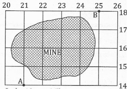
|
Scale: 10m to 0.5km |
(i) Calculate the area of the mine.
(ii) Find the bearing of point B from A.
(iii) Give the direction of A from B.
(iv) State the grid reference of A and B.
(b) Carefully study the climatic graph given and then answer the questions that follow.
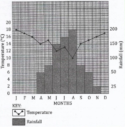
|
|
(i) Calculate the annual range of temperature.
(ii) Calculate the annual rainfall for the station.
(iii)Calculate the mean annual rainfall for the station.
(iv)Suggest the type of climate for the station.
(v) Give reasons for the suggestion you have given in (iv) above.
10. Describe the factors that influence the climate of a place
FORM ONE GEOGRAPHY EXAM SERIES 66
FORM ONE GEOGRAPHY EXAM SERIES 66
MINISTRY OF EDUCATION, REGIONAL ADMINISTRATION AND LOCAL GOVERNMENT
SECONDARY EXAMINATION SERIES
GEOGRAPHY TERMINAL EXAMINATION
FORM ONE-2021
Time: 2:30Hours
Instructions.
- This paper consists of section A, B and C with a total of 10 questions
- Answer all questions in section A and B and TWO questions from section C.
- Section A carries 25 marks, section B 45 marks and section C 30 Marks
- All answers should be written in the spaces provided.
- All communication devices, calculators and any unauthorized material are not allowed in examination room.
- Write your number on every page of your answer booklet.
SECTION A (35 Marks)
Answer All questions in this section.
- For each of the items (i)-(x), choose the correct answer from the alternatives given.
i) The outermost layer of the earth is called;
A. The mantle
B. The crust
C. The sial
D. Sima.
ii) Fold mountains are formed by;
- Faulting
- Outflow of lava over the land
- Wrinkling of the earth crust
- Sinking of the earth crust.
iii) Dormant volcanic mountains are those which;
- Have never experienced eruptions
- Have erupted once but are nolonger active
- Continue to erupt occassionaly
- Erupt only then there is an earth quake.
iv) Saltiness in lakes have accumulated over a long period of time from;
- Volcanic activities in the oceans
- Salt rocks lying at the bottom of the sea
- Land materials blown by wind into the sea
- Rivers that pour their water into the sea
- Land materials brought into the sea by moving ice.
v) ocean currents are set in motion by;
- Differences in temperature of water in the ocean
- The earth rotation on its axis
- Land materials blown into the ocean by wind
- Prevailing wind that blows over the ocean
- Gravitational force
vi) the largest ocean on earth is;
- Indian ocean
- Pacific ocean
- Atlantic ocean
- Meditererian sea
- Red sea
Vii) Which of the following statement are correct?
- Ocean water has a uniform temperature from bottom to top.
- The surface temperature of the ocean decreases polar wards
- Ocean water in the tropics is warmer on the surface than in its bottom.
- In the polar regions, ocean water temperature is warmer at the bottom than it is at the surface
viii) A raised part of an ocean is called;
- A ridge
- Ocean deeps
- Continental shelf
- Deep sea plains
ix) Which of the following is a fold mountain?
- Ruwenzori
- Mt. Kilimanjaro
- Mt. Usambara
- Mt. Evarest.
x) Which of the following is an example of an extinct volcano?
- Mt. Elgon
- Mt. longonot
- Black forest mountains
- Mt. Sinai.
- Matching items questions;
| List A | LIST B |
|
|
SECTIONB.
- Name the three layers of the earth
(b) Briefly explain the composition of the atmosphere.
- Differentiate between a continent and an ocean
(b) Name the continents of the earth
- Briefly explain the following;
i) A plain
ii)Plateaus
(b) Differentiate between fold mountains, block mountains and volcanic.
- Give two examples, of each of the following;
i. Fold mountains
ii. Volcanic mountains
iii. Fold mountains.
(b) Explain how volcanic mountains are formed.
- Outline uses of water in daily life
(b) Give the meaning of the following terms;
i) A cape
ii) A peninsula
iii) A ridge.
- Describe why it is important to study geography
- Using a diagram, explain how relief rainfall is formed
FORM ONE GEOGRAPHY EXAM SERIES 58
FORM ONE GEOGRAPHY EXAM SERIES 58
THE PRESIDENT’S OFFICE
MINISTRY OF EDUCATION, REGIONAL ADMINISTRATION AND LOCAL GOVERNMENT
SECONDARY EXAMINATION SERIES
GEOGRAPHY MID TERM EXAMINATION
FORM ONE-2021
Time: 2:30Hours
Instructions.
- This paper consists of section A, B and C with a total of 10 questions
- Answer all questions in section A and B and TWO questions from section C.
- Section A carries 25 marks, section B 45 marks and section C 30 Marks
- All answers should be written in the spaces provided.
- All communication devices, calculators and any unauthorized material are not allowed in examination room.
- Write your number on every page of your answer booklet.
SECTION A (35 Marks)
Answer All questions in this section.
- For each of the items (i)-(x), choose the correct answer from the alternatives given.
- Which of the following is not affected by the earth’s rotation?
- Movement of ocean current
- Direction of prevailing wind
- Changes of day and night
- Changes in seasons.
- The seasons of the year are caused by;
- Rotation of the earth
- Lunar eclipse
- Revolution of the earth
- Solar eclipse
- The term Geography refers to:
- Describing of the Earth
- Geo and Graphien
- The study of man and his surroundings
- All of the above.
- Geomorphology is regarded as;
- The study of soil science
- The study of Geology
- The study of physical features
- The study of flora and fauna.
- Geography is sub – divided into;
- Practical, Human, Economic.
- Physical, Practical, Demography
- Human – economic, practical and physical.
- Practical, Survey, Statistics.
- Agriculture, mining, lumbering can be studied in:
- Physical Geography.
- Human and economic Geography.
- Plant Geography.
- Practical and physical Geography.
- The Central body of the solar system is?
- The planet
- The Sun
- The Moon
- The Earth
- The spinning of the earth on its own axis is known as:-
- Rotation
- Revolution
- Day and night
- Distance
- A ship moves to the West and cross the International data line. What happens with regard to time gained or lost?
- No time is gained or lost
- One whole day is lost
- One whole day is gained
- One whole day is repeated
- The four seasons which occur on the earth’s surface are as a result of________
- Rotation of the earth
- Ferrell’s law
- The tilting of the earth on its own axis.
- Revolution of the earth.
2. Match the items from list A with those in list B.
| LIST A | LIST B |
|
|
3. Write TRUE for a correct statement and FALSE for incorrect statement.
- The study of Geography does not involve human evolution and his surrounding_______
- Climatology is a branch of practical geography that deals with atmospheric conditions studied for a long period of time___________
- Demography deals with economic activities__________
- Research is a branch of practical geography that deals with a systematic investigation____
- Environment is what surrounds us_________
- The study of rocks is called geology______
- Geography is originated from Greek words Geo and Graphien_______
- Biogeography studies the distribution of plants and animals______
- If you undertake the knowledge of Geography you might be a geologist___________
- The Earth’s orbit is more spherical than elliptical in shape
SECTION B45 (Marks)
Answer all Questions in this section.
4.
(a) Name five elements of the solar system.
(i) …………………………………………………………………………..
(ii) …………………………………………………………………………..
(iii) ………………………………………………………………………….
(iv) ………………………………………………………………………….
(v) ………………………………………………………………………….
(b) List down two important Great circles
(i) ………………………………………………………………………..
(ii) ………………………………………………………………………..
(c) Mention two types of eclipses.
(i) ……………………………………………………………………….
(ii) ……………………………………………………………………….
5. Differentiate between the following geographical terms.
a) Aphelion and perihelion
b) Longitude and Latitude.
c) Umbra and penumbra.
d) Lunar and solar eclipse.
6. Explain for (4) reasons to prove that the earth rotates on its own axis.
a) …………………………………………………………………
b) …………………………………………………………………
c) …………………………………………………………………
d) …………………………………………………………………
SECTION C
Answer Any two questions from this section
7. Give the meaning of the following geographical terms:-
a) Geography
b) Physical geography
c) Regional geography
d) Practical geography
8. List down five human and economic activities
a) …………………………………………………..
b) ………………………………………………….
c) …………………………………………………
d) …………………………………………………
e) …………………………………………………
9. (a) Why is International Date Line not straight at a certain point?
(b). Give five evidences to prove the earth’s shape
a) ………………………………………………………………
b) ………………………………………………………………
c) ………………………………………………………………
d) ………………………………………………………………
e) ………………………………………………………………
(c). If the local time (Mean) of Mogadishu (Republic of Somalia) 45 ![]() E is 12:35pm, what will be the local mean time of Mwanza (United Republic of Tanzania) 36
E is 12:35pm, what will be the local mean time of Mwanza (United Republic of Tanzania) 36 ![]() E?
E?
FORM ONE GEOGRAPHY EXAM SERIES 42
FORM ONE GEOGRAPHY EXAM SERIES 42
PRESIDENT'S OFFICE
REGIONAL ADMINISTRATION AND LOCAL GOVERNMENT
ANNUAL EXAMINATION
GEOGRAPHY FORM ONE
NAME…………………………………………..CLASS……………………………TIME: 2HRS
INSTRUCTIONS.
- This paper consists of sections A, B and C with a total of ten (10) questions.
- Answer all questions in section A and B and two (2) questions from section C
- All writing must be in blue or black ink.
- All answers must be written in the space provided.
- Calculators, cellular phones and any unauthorized materials are not allowed in the examination room.
- Write your Examination Number at the top right corner of every page.
SECTION A (25 Marks)
Answer all questions in this section.
SECTION A:
1. For each of the following (I-X) choose the most correct answer from the given alternatives and write its letter besides the item number.
(i) Temperature decreases with altitudes at the rate of:-
(a) 1.6C? for every 100 metres
(b) 16C? for every 100 metres
(c) 0.6C? for every 100 metres
d) 0.16C? for every 100 metres
(ii) The rotation of the earth causes the following except?
(a) Day and night
(b) The different of one hour between two meridians of 15? width.
(c) Seasons
(d) The deflection of winds and ocean current.
(iii) Which of the following is the proper arrangement of the first five (5) planets of the solar systemaccording to the distance from the Sun starting with nearest planet?
(a) Mercury, Earth, Venus, Saturn and Mars.
(b) Mercury, Venus, Earth, Mars and Jupiter.
(c) Venus, Mercury, Mars, Earth and Jupiter.
(d) Mars, Earth, Mercury, Jupiter and Venus.
(iv) One of the following groups are features of the ocean floor:-
(a) Ridge, basin, plateau and waterfalls.
(b) Continental shelf, basin and waterfalls.
(c) Host, plain, basin and volcano
(d) Trend, Continental shelf and continental slope.
(v) Isobars are lines drawn on a map to join all places with the same:-
(a) Amount of rainfall
(b) Height above sea level
(c) Amount of Temperature
(d) Atmospheric pressure
(vi) The condition of atmosphere recorded over a long period of time is:-
(a) Climate
(b) Temperature
(c) Weather
(d) Atmospheric pressure.
(vii) The side of a Mountain facing away from the direction of the wind is called?
(a) Fore side
(b) Wind wards side
(c) Front
(d) Lee ward side.
(viii) The best description of the term Geography:-
(a) The study of the solar system
(b) The study of the planets.
(c) The study of man in relation to his environment
(d) The study home of man.
(ix) The planets:-
(a)Are bodies that rotate around the Sun
(b)Are bodies that revolve around the Sun.
(c) Are stars.
(d) More of the above.
(x) Which are is the Large Scale among the following?
(a) The denominator is usually medium
(b) The denominator is small
(c) The denominator is large
(d)The denominator range from large to medium
2. Match the items in column A with those in column B by writing the letter of the correct answer against its corresponding item number in column A.
| LIST A | LIST B |
| (i) Land that is completely surrounded by water. (ii) The planet that is known to support life is……. (iii) Geography originated from two Greek words “geo” and…… (iv) Farthest position of the earth from the sun (v) The wind in which blows from the sea to the land | A. Anemometer B. Fold Mountain C. Island D. Isotherms E. 0.6 C? for every 100 metres. F. Isohyets G. Sea breeze H. Aphelion I. Earth J. Convectional rainfall K. Graphein L. Perihelion. |
3. Write TRUE or FALSE against the following statements.
(i) Statement scale is expressed in fraction___________
(ii) Winter is the one of the seasons of the year__________
(iii) Elements of weather are the same as element of climate___________
(iv) Winds blows from areas of low pressure to high pressure____________
(v) The Sun is the source of all energy____________
(vi) Humidity is measured by a Hygrometer__________
(vii) Representative Fraction Scale (R.F) is a way of expressing the scale of a map by the one of linear scale_________
(viii) Fold Mountain is the result of high pressure and temperature under the ocean floor_________
(ix) Lake Tanganyika is a rift Valley Lake__________
(x) Television is an example of Mass Media_______
SECTION B (45 Marks)
Answer all questions in this section.
4. Mention five element of Weather.
5.(a)List five essentials of a good Map
(b) Mention three (3) ways in which the scale of the Map can be represented.
(i)…………………………………………………………….
(ii) ……………………………………………………………
(iii) …………………………………………………………..
(c) Mention two types of Maps according to Scale
1………………………………………2…………………………………………
6. (a) Study carefully the diagram below and label letters A, B, C, D, E, F and G.
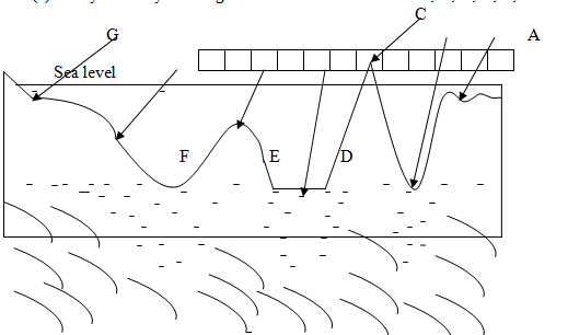
(b) Mention four factors which affect the temperature of the place.
(c) Change the following scale:
(i) 1: 50,000 into statement scale
(ii) One centimeter on the map represents two Kilometer on the ground. Change into (R.F) scale orFraction Scale.
(iii) Calculate the distance if the Map Scale is 1:50,000 and the distance obtained from point A to point B is 24 centimeter.
7. Carefully, study the climatic graph given and then answer the questions.
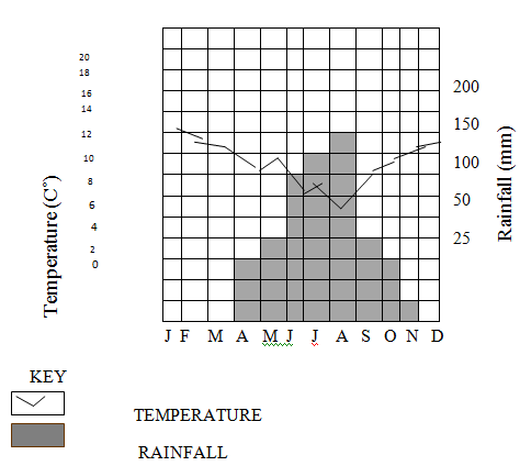
(i) Calculate the annual range of temperature
(ii) Calculate the annual rainfall for the stations
(iii) Calculate the mean annual rainfall for the station
(iv) Suggest the type of climate for the station.
(v) Give reasons for the suggestion you have given in (iv) above.
SECTION C (30 Marks)
Answer two (2) questions from this section.
- Outline the importance of studying geography
- Briefly explain the reasons why the earth is round
- What are the factors that affect the climate of a place
- Discuss the effects of rotation and revolution of the earth.
FORM ONE GEOGRAPHY EXAM SERIES 32
FORM ONE GEOGRAPHY EXAM SERIES 32
THE PRESIDENT'S OFFICE
MINISTRY OF REGIONAL GOVERNMENT AND LOCAL GOVERNMENT
AUGUST-SEPTEMBER EXAMINATION SERIES
GEOGRAPHY FORM-1
2020
TIME: 2:30 HRS
INSTRUCTIONS.
- This paper consists of sections A, B and C with a total of ten (10) questions.
- Answer all questions in section A and B and two (2) questions from section C
- All writing must be in blue or black ink.
- All answers must be written in the space provided.
- Calculators, cellular phones and any unauthorized materials are not allowed in the examination room.
- Write your Examination Number at the top right corner of every page.
SECTION A (25 Marks)
Answer all questions in this section.
1. For each of the items (i) – (ii), choose the correct answer from among the given alternatives and write its letter in the box provided.
(i) One characteristics of equatorial climate is:-
- Low rainfall
- Moderate temperature
- Low humidity
- Thick forest.
(ii) Cultivation of cash crops based on application of advanced technology is called?
- Subsistence agriculture
- A large scale agriculture
- Mixed system agriculture
- A small scale agriculture
(iii)Which one of the following instrument is not the component of a weather station?
- Rain gauge
- Wind vane
- Microscope
- Stevenson screen
(iv)Which type of climate among the following is different from the other?
- Mediterranean
- Savanna
- Hot desert
- Equatorial
(v)The height above the sea level is called:
- Altitude
- Contour
- Latitude
- Ocean
(vi)All meridians pass through:
- the North and South Poles
- the East and West poles
- the Latitudes and Longitudes
- the Greenwich meridian
(vii)The process whereby water vapour is turned into water droplets is called:
- evaporation
- condensation
- saturation
- transpiration
(viii)A feature formed as a result of either natural or artificial depression varying in size on the earth surface is called:
- Island arc
- Fold mountain
- Rift valley
- Basin
(ix)A feature formed as a result of either natural or artificial depression varying in size on the earth surface is called:
- Island arc
- Fold mountain
- Rift valley
- Basin
(x) Contours are lines drawn on maps to join places with the same:
- height between mountains
- altitude above sea level
- areas between valleys
- features in mountains.
2. Match the items in List A with the responses in List B by writing the letter of the correct response below the corresponding item number in the table provided.
| List A | List B |
| (i) Moons of the planets. (ii) Pieces of hard matter falling from outer space. (iii) Natural satellites of the earth (iv) The centre of the solar system. (v) Heavenly body that posses and transmit its own light. |
|
3. Write TRUE for the correct statement and FALSE for the incorrect statement.
- The Earth’s orbit is more spherical than elliptical in shape
- The moon generates light during the night
- Geography deals with Earth’s features only
- Mercury is the largest planet in the solar system
- Equator is the line which divides the earth into two equal hemispheres
- The solar system contains the sun and its planets which revolve around the sun in elliptical orbits.
- The Greet word “Geo” in the concept of Geography refers to: draw, write about or describe the earth.
- The term geography can be defined as the study of the earth as a home of man and other living organisms.
- Physical geography is concerned with field study, photography work, map work and statistics.
- One of the importance of studying geography is to understand the social and geographical problems and how to solve them.
SECTION B (45 Marks)
Answer all questions in this section.
4.(a) Mention five sources of water in Tanzania.
(b) Mention five uses of water.
(c) Briefly describe the following terms:
(i)Hydrological cycle
(ii)Water conservation
(iii)Water population
5.(a) Outline five evidences to verify that the Earth is spherical.
![]() (b) Differentiate the following terms:
(b) Differentiate the following terms:
![]() (i) Meteors and satellites
(i) Meteors and satellites
(ii) Sea and lake
6.(a) Outline four ways of determining direction of a place on a map.
(b) List four features of the Representative Fraction (RF) scale.
(c) Suggest two ways of measuring areas with irregular shapes.
7.(a) Mention five features of the ocean floor.
(b) Name the five largest oceans in the world.
(c) Mention five largest lakes in the world.
(d) Differentiate the following terms:
(i)Temperature and humidity
(ii)Minimum and maximum thermometer
(iii) Pressure and wind
8.(a) Convert:
(i)1:50,000 into statement scale.
(ii)lcm to 4.57km into representative fraction scale.
(iii)If the map distance of a certain river on a topographical map is 15 centimeters, calculate the actual ground distance of that river in kilometers given that the map scale is 1:50,000.
(b) (i) Give a difference between Sketch maps and Atlas maps.
(ii) Give three types of northings.
(iii) Name two types of grid reference systems.
9. (a) Distinguish the following terms:
- Solar system and solar energy
- Raw materials and manufacturing industries
- Map and scale of a map
- Plateau and mountain
(b)
- Define lunar eclipse.
- Draw a well labelled diagram to show lunar eclipse.
10. (a) Giving one example, briefly explain four main categories of mountain.
(i) …………… …………… …………… ……………
(ii) ……………… ……………… ………………
(iii) …………… ……………… ……………… ………………
(iv) ……………… ……………… ……………… ………………
(b) (i) Briefly explain the formation of rift valleys.
(ii) List five rift valley lakes in East Africa.
FORM ONE GEOGRAPHY EXAM SERIES 20
FORM ONE GEOGRAPHY EXAM SERIES 20
THE PRESIDENT’S OFFICE MINISTRY OF EDUCATION, LOCAL ADMINISTRATION AND LOCAL GOVERNMENT
GEOGRAPHY- TERMINAL EXAMINATION-MAY
FORM ONE
TIME: 2HRS 2020
NAME:_______________________________________________ CLASS:___________
INSTRUCTIONS
- This paper consists sections A and B
- Answer All questions in section A and B
- Write your names and class on every page
SECTION A
MULTIPLE CHOICES
1. Choose the most correct letter from the following questions which bring the correct meaning and write it in the box provided below:
(i) The compass bearing for South is:
- 1350
- 1800
- 2250
- 0450
(ii) The four seasons which occur on the Earth’s surface are a result of:
- Ferrell’s law
- Rotation of the Earth
- Revolution of the Earth
- The tilting of the Earth on its axis
(iii) The structure of the Earth is composed of:
- Crust, Mantle and Core
- Carbon and Sodium
- Silicon and Alumina
- Sima and Sial
(iv) The farthest position from the sun in the orbit of the Earth is called:
- Lunar eclipse
- Aphelion
- Umbra
- Penumbra
(v) The path through which planets revolve around the sun is known as:
- Axis
- Solar system
- Orbit
- Galaxy
(vi) The time taken by a planet to revolve around the sun depends on:
- The energy received from the sun
- The hotness of the planets
- The heat generated from the sun
- Its relative distance from the sun
(vii) Water and air currents do not move in straight lines due to spinning effect of the earth. The term used to describe this situation is:
- Deflation
- Reflection
- Direction
- Deflection
(viii) Scientists whose work is to study about the solar system and stars are called:
- Astronomers
- Geologists
- Astronomy
- Comets
(ix) The central body of the solar system is:
- The planets
- The sun
- The moon
- The Earth
(x) The total number of longitudes is:
- 3660
- 3600
- 365
- 3770
| i | ii | iii | iv | v | vi | vii | viii | ix | x |
|
|
|
|
|
|
|
|
|
|
|
2. Match the items in list A with correct responses in list B by writing its letter in a space provided
LIST A
- Equator __________
- Summer solstice___________
- Perihelion _____________365 days ______________________
- Mathematical geography________
- Gleoid __________
- Galaxy _____________
- Lunar eclipse ________________
- Satellite _____________
- International Date Line___________
LIST B
- From East to West
- Large system of stars in the outer space
- Mercury and Saturn
- From West to East
- Revolution of the Earth
- Moon
- 1800
- 00
- The sun is overhead at the tropic of capricon
- 3rd January
- Branch of Geography deals with calculations
- Oblate spherical shape of the earth
- 4th July
- Earth is between moon and sun
3. Write TRUE for true statements and FALSE for false statements
- Contour terracing in agriculture aims at preserving soil erosion_______
- Objects with leading heads and bright tails are called comets_________
- Good railway and road networks stimulate trade and commerce_______
- The Earth rotates from West to East through its orbit________
- Daily rising and falling of tides is the result of Earths revolution_______
- All planets use the same amount of time to complete one orbit________
- All latitudes are great circles ______
- Lake Tanganyika is a good example of a rift valley lake:______
- Industrialization is not an agent of air pollution_______
- The Earth rotates on its own axis for 367 days_______
SECTION B
3. Define the following:
- Longitudes
- The sun
- Great circle
- Prime meridian
- Equator
4. Draw a well labeled diagram of lunar eclipse
5. Examine two motions of the Earth
6. What are the four results of rotation?
7. Mention six (6) evidences which proves that the shape of the earth is sphere
9. Differentiate between the following geographical terms.
- Aphelion and perihelion
- Longitude and Latitude.
- Umbra and penumbra.
- Lunar and solar eclipse.
10. Write the TIME for the following Longitudes
- 150 E __________________
- 450 W _________________
- 300 E __________________
- 750 W _________________
- 600 E __________________
FORM ONE GEOGRAPHY EXAM SERIES 13
FORM ONE GEOGRAPHY EXAM SERIES 13
THE MINISTRY OF EDUCATIO AND VOCATIONAL TRAINING
FORM ONE MID TERM EXAMINATIONS- MARCH 2020
013 GEOGRAPHY
Duration: 2:30 Hours
INSTRUCTIONS.
- This paper consists of sections A, B and C with a total of ten (10) questions.
- Answer all questions in section A and B and two (2) questions from section C
- All writing must be in blue or black ink.
- All answers must be written in the space provided.
- Calculators, cellular phones and any unauthorized materials are not allowed in the examination room.
- Write your Examination Number at the top right corner of every page.
SECTION A (25 Marks)
Answer all questions in this section.
1. For each of the items (i) � (ii), choose the correct answer from among the given alternatives and write its letter in the box provided.
(i) Temperature decreases with altitudes at the rate of:-
- 1.6C? for every 100 metres
- 16C? for every 100 metres
- 0.6C? for every 100 metres
- 0.16C? for every 100 metres
(ii) The rotation of the earth causes the following except?
- Day and night
- The different of one hour between two meridians of 15? width.
- Seasons
- The deflection of winds and ocean current.
(iii) Which of the following is the proper arrangement of the first five (5) planets of the solar system according to the distance from the Sun starting with nearest planet?
- Mercury, Earth, Venus, Saturn and Mars.
- Mercury, Venus, Earth, Mars and Jupiter.
- Venus, Mercury, Mars, Earth and Jupiter.
- Mars, Earth, Mercury, Jupiter and Venus.
(iv) The following is a set of sub � braches of physical geography except?
- Biography, climatology, pedology.
- Geomorphology, pedology, climatology.
- Pedology, biogeography, biography.
- None of the above.
(v) Geography helps the learner to acquire the following things in his/her life except.
- Knowledge and skills
- Understanding their environment
- Guessing future events.
- Conserve their environment.
(vi) Physical geography studies about;
- Mining, fishing, farming.
- Climate, rocks and water bodies.
- Lumbering, Agriculture, mining.
- All of the above.
(vii) The study of physical features is called?
- Geomorphology
- Geology
- Biogeography
- Flora and fauna
(viii) The best description of the term Geography:-
- The study of the solar system
- The study of the planets.
- The study of man in relation to his environment
- The study home of man.
(ix) The planets:-
- Are bodies that rotate around the Sun
- Are bodies that revolve around the Sun.
- Are stars.
- More of the above.
(x) Which are is the Large Scale among the following?
- The denominator is usually medium
- The denominator is small
- The denominator is large
- The denominator range from large to medium
2. Match the items in column A with those in column B by writing the letter of the correct answer against its corresponding item number in column A.
| LIST A | LIST B |
| (i) Land that is completely surrounded by water. (ii) Wind is measured by instrument called. (iii) The planet that is known to support life is��. (iv) Geography originated from two Greek words �geo� and�� (v) The wind in which blows from the sea to the land
| A. Anemometer B. Fold Mountain C. Island D. Isotherms E. 0.6 C? for every 100 meters. F. Isohyets G. Sea breeze H. Aphelion I. Earth J. Convectional rainfall K. Graphein L. Perihelion.
|
3. Write TRUE for a correct statement and FALSE for incorrect statement.
a) The study of Geography does not involve human evolution and his surrounding_______
b) Climatology is a branch of practical geography that deals with atmospheric conditions studied for a long period of time___________
c) Demography deals with economic activities__________
d) Research is a branch of practical geography that deals with a systematic investigation____
e) Environment is what surrounds us_________
f) The study of rocks is called geology______
g) Geography is originated from Greek words Geo and Graphien_______
h) Biogeography studies the distribution of plants and animals______
i) If you undertake the knowledge of Geography you might be a geologist___________
SECTION B (45 Marks)
Answer all questions in this section.
4. Mention five element of Weather.
(i)
(ii)
(iii)
(iv)
(v)
5. (a) List five essentials of a good Map
(i)����������������..
(ii) ����������������.
(iii)����������������.
(iv)����������������.
(v)����������������...
(b) Mention three (3) ways in which the scale of the Map can be represented.
(i)�����������������������.
(ii) �����������������������
(iii) ����������������������..
(c) Mention two types of Maps according to Scale
1��������������� 2����������������
6. By use a simple diagram, illustrate the solar and lunar eclipse.
SECTION C (30 Marks)
Answer two (2) questions from this section.
7. (a) Define the term, �solar system�
(b) Briefly explain about the components of the solar system.
8. Write short notes on;
a) Pedology
b) Practical geography
c) Geology
d) Human � economic geography.
9. Explain in short importance of Geography.
10. Identify four things which are found in the environment.
FORM ONE GEOGRAPHY EXAM SERIES 7
FORM ONE GEOGRAPHY EXAM SERIES 7

DOWNLOAD LEARNING HUB APP NOW

SORRY, YOU CAN'T VIEW THIS MARKING SCHEME PLEASE DOWNLOAD LEARNING HUB APP FROM PLAYSTORE TO GET FULL ACCESS TO ALL MARKING SCHEME!!
Click Here To Download Learning Hub Tanzania App
SAMAHANI, HUWEZI KUFUNGUA MAJIBU YA MTIHANI, TAFADHALI PAKUA APP YA LEARNING HUB TANZANIA ILI KUWEZA KUFUNGUA MAJIBU YA MITIHANI KATIKA TOVUTI HII!!
Bofya Hapa Kupakua App Ya Learning Hub Tanzania
Hub App
 For Call,Sms&WhatsApp: 255769929722 / 255754805256
For Call,Sms&WhatsApp: 255769929722 / 255754805256  RATIBA NECTA KIDATO CHA IV 2026
Matokeo Darasa VII 2025
Matokeo KIDATO CHA II 2024
Matokeo Darasa IV 2024
SECONDARY REGIONAL EXAMS
PRIMARY REGIONAL EXAMS
FORM VI NECTA REVIEWS
FORM IV NECTA REVIEWS
FORM II NECTA REVIEWS
STD VII NECTA REVIEWS
STD IV NECTA REVIEWS
SECONDARY EXAMS SERIES
PRIMARY EXAMS SERIES
PRIMARY SUBJECT NOTES
SECONDARY SUBJECT NOTES
SECONDARY TOPICAL EXAMS
SECONDARY TOPICAL QUESTIONS
PRIMARY TOPICAL QUESTIONS
PRACTICAL EXAMS & NOTES
SECONDARY REGIONAL EXAMS
DOWNLOAD SUBJECT NOTES
SCHEMES OF WORK (PRIMARY & SECONDARY)
LESSON PLAN
SECONDARY LOG BOOKS
PRIMARY LOG BOOKS
LITERARY WORKS / UCHAMBUZI VITABU
METHALI ZOTE ZA KISWAHILI
Vitendawili Vya Kiswahili
FORM VI RESULTS 2024
FORM FIVE SELECTION 2024
MATOKEO KIDATO CHA IV 2023
FORM ONE SELECTION 2024
FORM VI RESULTS 2023
Matokeo Darasa IV 2022
RATIBA NECTA KIDATO CHA IV 2026
Matokeo Darasa VII 2025
Matokeo KIDATO CHA II 2024
Matokeo Darasa IV 2024
SECONDARY REGIONAL EXAMS
PRIMARY REGIONAL EXAMS
FORM VI NECTA REVIEWS
FORM IV NECTA REVIEWS
FORM II NECTA REVIEWS
STD VII NECTA REVIEWS
STD IV NECTA REVIEWS
SECONDARY EXAMS SERIES
PRIMARY EXAMS SERIES
PRIMARY SUBJECT NOTES
SECONDARY SUBJECT NOTES
SECONDARY TOPICAL EXAMS
SECONDARY TOPICAL QUESTIONS
PRIMARY TOPICAL QUESTIONS
PRACTICAL EXAMS & NOTES
SECONDARY REGIONAL EXAMS
DOWNLOAD SUBJECT NOTES
SCHEMES OF WORK (PRIMARY & SECONDARY)
LESSON PLAN
SECONDARY LOG BOOKS
PRIMARY LOG BOOKS
LITERARY WORKS / UCHAMBUZI VITABU
METHALI ZOTE ZA KISWAHILI
Vitendawili Vya Kiswahili
FORM VI RESULTS 2024
FORM FIVE SELECTION 2024
MATOKEO KIDATO CHA IV 2023
FORM ONE SELECTION 2024
FORM VI RESULTS 2023
Matokeo Darasa IV 2022


