PRIME MINISTER’S OFFICE, REGIONAL ADMINISTRATION AND LOCAL GOVERNMENT
FORM FOUR TERMINAL EXAMINATION
013 GEOGRAPHY
(For Both School and Private candidates)
Time: 3:00 Hours Year: 2026
Instructions
- This paper consists of three sections A, B and C with a total of eleven (11) questions.
- Answer all questions in section A and B and any two (02) questions from section C.
- Section A carries sixteen (16) marks, section B fifty-four (54) marks and section C
carries thirty (30) marks. - All writings should be in blue or black ink except for drawing which must be in pencil.
- Map extract of LIWALE (Sheet 280/4) is provided.
- Programmable calculators, communication devices and unauthorized materials are not
allowed in the examination room. - Write your Examination number on every page of your answer booklet (s).
SECTION A: (16 Marks)
Answer all questions from this section
1. For each of the items (i)-(x), choose the correct answer from among the given alternatives and write its letter beside the item number in the answer sheet provided.
i. In order rain to be formed it has to pass through some stages; as an expert in geography studies identify the correct processes of rain formation.
- Cooling, evaporation, condensation and precipitation
- Evaporation, cooling, precipitation and rainfall
- Evaporation, cooling, condensation and rainfall
- Evaporation, precipitation, condensation and cooling
- All the above
ii. Soil is one among the factors which determine economic activities together with:
- Climate
- Type of zone
- Nature of people
- Agricultural activities
- Equatorial zones
iii. The tourist reported enjoying the temperature of Ihefu wetland in Mbeya at 1500 meters above sea level, which is 32ºC. They also planned to travel from Ihefu to Unguja in Zanzibar which is at sea level. What might be the temperature experienced by the tourist in Zanzibar?
- 23°C
- 0.6°C
- 9°C
- 41°C
- 19°C
iv. Majaliwa visited a hot desert Landscape. During his visit managed to learn that some rocks used to crack and peel-off. The geographical term for this process is referred to as:
- Salt crystallization
- Exfoliation
- Carbonation
- Granular disintegration
- Hydrolysis
v. All the following are famous tourist attraction sites in Tanzania except?
- Mikumi wildlife, Tarangire and Ruaha reserve.
- Serengeti national park, Mount Kilimanjaro and Mikumi
- Selous reserve, Tarangire and Mikumi Park
- Tsavo, Turkana and Oldonyo Lengai
- Tarangire, Ruaha reserve and Serengeti national park
vi. At which stage of the river is deposition dominant?
- The young stage
- The old stage
- The middle stage
- All stages
- The upper course of the river
vii. Mwanahamisi was explaining to her grandmother about the layers of the earth’s atmosphere. She told her that the atmosphere comprises of different layers in which one of them support rain formation due to its high amount of water vapour. From your understanding what is the name of the layer?
- Mesosphere
- Stratosphere
- Exosphere
- Troposphere
- Ozone layer
viii. Suppose you are living in urban center and you are interested in keeping livestock. What type of livestock keeping would be suitable for you?
- Nomadism
- Ranching
- Transhumance
- Pastoralism
- Sedentary
ix. Robert is living near the mountain within the time he noticed the bending of truck of trees and fences downward the slope. Identify the type of process occurred.
- Land slide
- Mudflow
- Soil creep
- Rock fall
- Soil erosion
x. Marine erosion is a constant action of;
- Wind
- Wind and running water
- Wave, current and tides
- Swash and backwash
- Wave break
2. Match the items in list A with the correct response in list B by writing the letter of the corresponding response beside the items number in the answer sheet (s) provided
| LIST A | LIST B |
|
|
Section B (54 Marks)
Answer all questions from this section
3. Carefully study the map extract of LIWALE (sheet 280/4) and answer the questions that follow:
- Briefly describe two possible reasons for the growth of Liwale town
- Giving reason, identify the dominant type of rock in the mapped area
- Describe three characteristics of the rock mentioned in (a)
- Calculate the area covered by woodland at grid reference of 820130 and 870130
- Show the methods used to show Liwale town
4. Tanzania Meteorological Agency (TMA) was wondering when they noted seasonal fluctuation of water volume in the river Ruaha. Pangani and Rufiji consecutively in four years 2020 -2023 in Millimeters as shown in the table below;
| YEARS/RIVERS | RUAHA | PANGANI | RUFIJI |
| 2020 | 50 | 45 | 70 |
| 2021 | 70 | 60 | 80 |
| 2022 | 75 | 50 | 85 |
| 2023 | 80 | 70 | 100 |
- With examples describe three reasons for the fluctuation of water volume in those rivers.
- Present the given data by using multiple bar graph.
- Comment on the graph drawn on seasonal fluctuation of water volume.
5. Group of researchers from Kisarawe District assigned a research work to find out critical reasons and solutions for truancy among students.
- You as a student, advice the researchers on best procedures to follow to have a successful work.
- Briefly explain any four uses of the findings obtained from research.
6. After learning different types of simple land survey students were asked to explain fruits of studying of chain survey but only Yoweri failed to explain. Assume you are a student who understood the lesson, how will you help him to explain fruits of chain survey? (Any six points).
7. “Volcanic eruptions are always constructive and destructive in nature”. With three points from each aspect validate the statement.
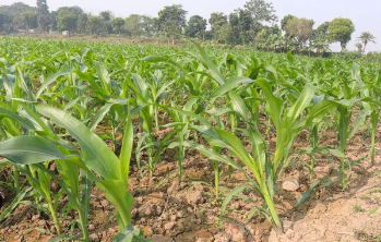
8. Carefully study the photograph provided below and then answers the questions that follow.
|
|

- Name the crop shown in the photograph above.
- Mention three necessary physical conditions for the growth of the crop.
- With two reasons determine the type of photograph
- Mention two contributions of economic activity taking place.
SECTION C (30 Marks)
Answer only two (02) questions from this section
9. “Life is only possible if the balance between the resources available and human population is maintained by all of us. Justify this statement by explaining any six (6) consequences of rapid population growth on environment.
10.“Energy is the essential service whose availability and quality determines success or failure of development endeavors”. In light of this statement, explain six (6) challenges facing power and energy harnessing in Tanzania
11.The government of United Republic of Tanzania has entered into agreement to release Dar es Salaam port with an international company known as DP World of Dubai. As a form four student prove with six (6) points that harbours with good infrastructure are important to Tanzania economy.
FORM FOUR GEOGRAPHY EXAM SERIES 252
FORM FOUR GEOGRAPHY EXAM SERIES 252
PRIME MINISTER’S OFFICE REGIONAL ADMINISTRATION AND LOCAL GOVERNMENT
FORM FOUR MIDTERM EXAMINATION
013 GEOGRAPHY
Time: 2:30 Hours March, 2026
Instructions
- This paper consists of sections A, Band C with a total of ten (11) questions.
- Answer all questions in section A and B and two (2) questions from section C.
- Map extract of SIKONGE (sheet 137/2) is provided.
- Programmable calculators, Cellular phones and any unauthorized materials are not allowed in the examination room.
- Write your Examination number on every page of your answer booklet (s).
SECTION A (16 MARKS)
Answer all questions in this section
1. For each of the items (i-x), choose the correct answer among the given alternatives and write its letter in the answer booklet (s) provided.
(i) It is a fact that ocean currents are set in motion, one among the reason for the movement of ocean current is
- Revolution
- Lunar eclipse
- Rotation of the earth
- Climatic change
- Volcanism.
(ii) Mr. Kasimba is keeping a group of animals in a permanent place, he does not move from place to place with his animals looking for pasture. What is the general term for the livestock keeping category Mr. Kasimba is practicing?
- Nomadic pastoralism
- Semi nomadic
- Transhumance
- Sedentary livestock keeping
- Commercial animal
(iii) An area of low pressure with high temperature is called?
- Doldrums
- Depression
- Cyclone
- Mountain region
- Equator.
(iv) An overhead sun occurs on the tropic of cancer at?
- 21st June
- 21st March
- 22nd December
- 23rd September
- 23rd June
(v) What will be the temperature of Bagamoyo 500m above the sea level, if the temperature of Same 1500m above the sea level is 150C?
- 24oC
- 25oC
- 26oC
- 26oC
- 21oC
(vi) Absence of drainage on the surface of the limestone region is the direct consequences of……..
- Presence of deep gorges
- Well jointed rocks
- Very low rain in the area
- Big river that swallow small water
- Absence of springs
(vii) People of Mtakuja village are not served by electricity; instead they are using the energy that are produced by inorganic materials (Plants and animals products) after broken down by bacteria in an oxygen free environment. What is the name of such energy?
- Biogas
- Solar energy
- Wind energy
- hydroelectric power
- Sun
(viii) Large masses of volcanic rocks often form the root of the fold mountains are called
- Sill
- Laccolith
- Volcanic cone
- Batholith
- Dyke.
(ix) The chairman of Sanya station village insisted his villagers that they should not enter in the reserved forest of the village. What do you think are the social – economic advantages of the reserved forest?
- Agriculture
- Mining
- Lumbering
- Forestry
- Tourism
(x) The geological time scale is the scheme of scale classified into three eras which one is correct sequence?
- Mesozoic, Paleozoic and Cenozoic
- Period, epoch and ages
- Paleozoic, Mesozoic and Cenozoic
- Cenozoic, Mesozoicand Paleozoic
- Tertiary, quaternary and Oligocene
2. Match the types rocks in list A with their corresponding explanation inlist B by writing the letter of the correct response beside the item number in the answer sheetprovided
| LIST A | LIST B |
|
|
SECTION B (54 Marks)
Answer all questions in this section.
3. Carefully study the Map Extract of SIKONGE (Sheet 137/2) provided, then answer questions that follow below:
(a) With supportive reason, identify thedominant type of rock found on the mapped area.
(b) With vivid evidences from the map, give three main human activities that are taking place on the mapped area.
(c) By using linear scale from the map, calculate the distance of Dry weather road from grid reference 738828 to 759882.
(d) Give the name of the method of showing relief which is found at grid reference 796849.
4. (a) Madam Rose recorded the outcome of his student’s performance in Geography weekly test as follows: 8, 22, 18, 16, 8, 4, 18, 10, 15, 16, 20, 16, 21, 4, 18, 13, 22, 12, 30, 23, 10, 20, 15, 6, 16, 8, and 2. Can you help Madam to find the following?
(i) Mean (iii) Median (ii) Mode (iv)Range
(b) With three points, show the application of the statistical data in daily life at (a) above.
5. Lilian is working in women affairs institution. She decided to conduct a research on the effects of abortion on academic performance for girl students in Katavi Region. She selected only five schools to represent others and then ten girl students were chosen from each school to be used as samples under study.
- What will be the best research approach for her study?
- Name the sampling technique used by Lilian.
- Give two reasons for why Lilian decided to use sample in her research?
- State two uses of her research output.
- Suggest three constraints which possibly faced her collecting date.
6. If you are given a task to conduct a chain survey around your school compound.
(a) What are the main three procedures you would use to carry out the task?
(b) Name three marking instruments which you would use.
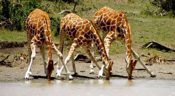
7. Study the following photograph and answer the questions that follow:
 |
- Name the crop shown on the photograph.
- What is the activity taking place on the photograph?
- With one evidence, suggest the scale of production of the crop shown.
- List down two conditions necessary for the growth of the crop shown on the photograph.
- Outline two factors that might affect the quality of the photograph given.
8. It is a geographical phenomenon that results to sudden shaking of the Earth and it causes some impacts to the population in the affected area.
- What is the phenomenon spoken about?
- Explain four impacts which might be caused by the geographical event named in (a) above.
- Suggest three precautionary measures to minimize the incidence of the phenomenon named in (a) above.
SECTION C (30 MARKS)
Answer two (02) questions from this section
9. The Minister of national resources and Tourism in Tanzania has been so much active inpromoting tourism sector. Despite the economic significance of the sector, there arenegative impacts to our country. Elaborate this statement by giving (six points).
10. In a Form three classroom, a Geography teacher stated that, “areas affected by vulcanism are not that bad”. Support teacher’s statement in six points.
11. “People do not live everywhere’’ Why? Give six reasons.
FORM FOUR GEOGRAPHY EXAM SERIES 233
FORM FOUR GEOGRAPHY EXAM SERIES 233


FORM FOUR GEOGRAPHY EXAM SERIES 218
FORM FOUR GEOGRAPHY EXAM SERIES 218
THE OFFICE OF THE PRESIDENT, REGIONAL ADMINISTRATION AND LOCAL GOVERNMENT.
SECONDARY EXAMINATION SERIES
MARCH 2025
GEOGRAPHY FORM FOUR
TIME: 2:30HRS
INSTRUCTIONS
1. This paper consists of three section A, B and C with a total of eleven (11) questions.
2. Answer all questions from section A and B and two questions from section C.
3. Section A carries sixteen (16) marks, section B carries fifty four (54) marks and section C carries thirty (30) marks.
4. Map extract of LIWALE sheet 280/4 is provided.
5. All writing should be in blue ink except diagrams which must be in pencil.
6. All communication devices and any unauthorized material are not allowed in the examination room.
7. Write your Examination number at the top right corner of every page.
1. For each of the items (i –x) choose the most from the given alternatives and write its letter beside the item number in the answer sheet (booklet) provided. (i) All the following are famous tourist attraction sites in Tanzania except;
A. Mikumi wildlife, Tarangire and Ruaha reserve.
B. Serengeti national park, Mount Kilimanjaro and Mikumi
C. Selous reserve, Tarangire and Mikumi Park
D. Tsaro, Turkana and Oldonyo Lengai
E. Tarangire, Ruaha reserve and Serengeti national park
(ii) SIMA and SIAL are separated by the zone called;
A. Sialic
B. Mohorovic discontinuity
C. Mesosphere
D. Conrad discontinuity
E. Gutenberg discontinuity
(iii) Chemical weathering is most dominant in areas of;
A. High temperature and high humidity
B. Low temperature and low humidity
C. High temperature and low humidity
D. Low temperature and high Humidity
E. Only high temperature
(viii) Suppose you are living in urban center and you are interested in keeping livestock. What type of livestock keeping would be suitable for you?
A. Nomadism
B. Ranching
C. Transhumance
D. Pastoralism
E. Sedentary
(ix) If the location of a point on a map is given by grid reference 365490, then;
A. 490 are northings
B. 490 are Eastings
C. 365 are degrees
D. 365 are northings
E. 365 are longitudes
(x) Soil is among factors which determines economic activities together with;
A. Climate
B. Type of zone
C. Nature of people
D. Agricultural activities
E. Equatorial zones
(viii) People living in Bukoba — Tanzania experienced sudden vibrations of the Earths surface caused by movement of the molten rocks below or within the crust Identify the instrument used to measure the magnitude of such vibrations;
A. Ritcher scale
B. Thermometer
C. Barometer
D. Hygrometer
E. Wind vane
(ix) Hamisi at Chungwa secondary school had an interest in conducting geographic research on challenges that face street children in cities. What will be the last stage for his research?
A. Data collection
B. Data presentation
C. Report writing
D. Data analysis
E. Data processing
(x) Students were digging the toilet pits around the school, they observed different layers of soil usually of different texture and colors What does the soil refer lo?
A. Soil profile
B. Soil texture
C. Soil stucture
D. Soil porosity
E. Sand soil
(vi) Dormant volcanic mountains are those which:
A. Have never experience eruption
B. Have erupted once but are no longer active
C. Continue to erupt occasionally
D. Erupt only when there is an earthquake
E. Erupt every
2. Match the descriptions of the major features of the earth in Column A with its responses in Column B by writing the letter beside the item number.
| Column A | Column B |
| i. A boundary between one drainage and the next ii. Extensive high altitude area with more or less uniform summit level iii. Natural depression on the earth’s surface iv. A piece of land surrounded by water v. Warmest continent in the world vi. A long narrow deep and steep sided depression between parallel faults on the earth’s surface | A. Island B. Block mountain C. Rift valley D. Asia E. Plateau F. Africa G. Water shed H. Basin |
SECTION B (54 Marks)
Answer all questions in this section
3. Carefully Study the map extracts of Liwale sheet 280/4 provided, then answer the questions that follow
(a) With supporting evidence from the map, describe settlement pattern of the mapped area.
(b) By giving the evidence from the map, name four social activities carried out in the area
(c) Calculate the area covered by forest using square method. Give your answer in Km2.
(d) Change the scale of the map into a statement scale
(e) By giving evidence from the map, describe two main types of transport found in the mapped area.
4. A sudden shake and vibration of the earth’s crust may have a number of outcomes
a. What is his geographical phenomenon
b. Outline four (4) outcomes of the phenomenon mention in (a) above
c. What is the instrument would be used to measure the intensity of the hazard named in (a)
d. Describe four (4) causes of the hazard in (a)
5. Study the data in the table below that shows the production of cash crops in Nyakanazi village in 000’tones from 2000 to 2003 and answer the questions that follow.
| YEARS | 2000 | 2001 | 2003 |
| CROPS | |||
| MAIZE | 200 | 260 | 275 |
| TEA | 100 | 200 | 180 |
| COFFEE | 150 | 220 | 200 |
QUESTIONS:
a. Present the data by means of multiple bar graph.
b. Give out two advantages and two disadvantages of the graph drawn in (a) above
6. The geography teacher at Kilimarondo Secondary school assigned his students to determine the relative heights of various points around their school. As an expert in surveying,
a. Advice the students of Kilimarondo secondary school the suitable survey technique for their assignment
b. Name at least four equipment you are likely to use.
c. Briefly describe four significance of the surveying technique named in (a) above.
7. Mr. Mpeligwa is the best geography teacher at Chimbe Secondary School. He teaches his students many types of photograph and one among the type of photograph is used in geographical research since can produce more accurate maps.
(a) With two reasons, suggest the type of photograph which can produce more accurate maps.
(b) Explain four similarities between the type of photograph mentioned in (a) above and map
(c) List three factors which may affect the quality of photograph
8. Draw and label eight (8) features of ocean floor.
9. (a) A group of students were sitting at a high steep face of a rock along the sea coast of the Indian Ocean, They observed the breaking movements of ocean waves in which ocean water is thrown up the beach and returned under gravity down the shore
i. What are the two wave processes the students observed?
ii. Mention four erosion processes involved in that ocean wave
b. Identify three factors that affect wave erosion
c. Draw a well labeled diagram to show the following features resulting from wave erosion
i. Blow hole
ii. Cave
10. “Despite of the fact that road transport causes a lot of accidents in Tanzania, most Tanzanians prefer road transport to Air transport”. With six points justify this statement.
11. Mr. Benedict he great believe that human activities can lead to the modification of the physical environment and distribution of people. On the other hand this may be as the result of the types of environment in the area. With six (6) points, explain the factors influences population distribution in Tanzania.
FORM FOUR GEOGRAPHY EXAM SERIES 210
FORM FOUR GEOGRAPHY EXAM SERIES 210
PRESIDENT OFFICE REGIONAL ADMNISTRATION AND LOCAL GOVERNMENT
SECONDARY EXAMINATION SERIES
COMPETENCE BASED ASSEMENT
ENGLISH LANGUAGE
FORM FOUR
MID-TERM-2 – AUG/SEPT 2024
TIME 3:00 HRS
INSTRUCTIONS
- This paper consists of sections A, B and C with a total of twelve questions
- Answer All questions in Sections A and B and three (3) questions from section C
- Mind your Handwriting and Neatness.
SECTION A (15 Marks)
Answer all questions in this section
- For each of the items (i) - (x), choose the most correct option from among the given alternatives and write its letter beside the item in answer sheet provided.
- Madam Silvia told Calvin to say the following statement loudly; " I wish you wish,but if you wish the witch wishes, I won't wish the wish you wish to wish." Thisstatement is known as?
A. a brainstormin
B. a pronunciation test
C. a creative composition
D. a tongue twister
E. a quiz
- A man with two beautiful wives Jane and Hasra has four children Aneth and Azary from his first wife Janeth while Asha and Azizi are from the second wife. In this relation Azizi is Jane's ....
A. Mother in law
B. Step mother
C. Co wife
D. Son
E. Step mother
- Having done his home work, the labourer sat down to rest. The underlined word indicates;
A. Past participle
B. Present continuous tense
C. Gerund
D. Past continous tense
E. Past perfect tense
- Among the given expressions, which one is suitable for asking direction?
A. Excuse me, I think I am lost. May you please show me the way to the police station?
B. I want to go to the police station, show me the way
C. Show me the way to the police station
D. Hey, show me the way to the police station
E. You show me the way to the police station
- You witnessed a fatal accident recently and you want to write a composition about it with details that will create vivid images in the reader's minds. What kind of composition will that be?
A. Narrative composition
B. Persuasive composition
C. Descriptive composition b
D. Argumentative composition
E. Expository composition
- Maduhu’s son travelled using a plane from Mwanza to Zanzibar. If you want to tell someone that Maduhu’s son travelled using a plane you simply say:
- He planted a plane
- He climbed a plane
- He boarded a plane
- He showed a plane
- He mounted a plane
- One of the functions of a dictionary is to show words that are pronounced the same but have different meaning and spelling. The words are called homophones, which pair best illustrates these words?
- Ugly- handsome
- Cry- weep
- You-ewe
- Leave- live
- Pupil-pupil
- Imagine you meet with your friend Kurambe Motto from Ngorongoro Arusha,who you graduated with in 2023 at Mlimanisecondary school, he greetedyou using the expression “How do you do?” how would you respond him?
- Thank you
- I do well
- I am ok
- How are you
- How do you do?
- Seldom do the youth use condom. this means the youth------------
- Use condoms often
- Have never worn condom
- Wear condoms rarely
- Find no use of so doing
- Frequently use condoms
- The prefect on duty said to other students at the assembly ground "Shhhh The teacher on duty is coming". What does the underlined sentence express?
A. A repeated activity before the moment of speaking
B. An activity going on at the moment of speaking
C. An activity going on after the moment of speaking
D. An activity completed in the moment of speaking
E. An activity completed before the moment of speaking.
- Match the following descriptions in LIST A with their corresponding adjectives in LIST B by writing the letter of the correct response beside the item number
| LIST A | LIST B |
|
|
SECTION B (54 marks)
Answer ALL questions in this section
- Future expression can be expressed in a number of ways. Construct one sentence using the given illustrations
- The use of simple present tense
- The use of present progressive tense
- The use of “be” + going + to infinitive of the verb
- The use of “be”+ about+ to infinitive of the verb
- The use of shall/will
- The use of “have”+ to infinitive form of the verb
- Imagine that you meet your friend Magesa Manyanda who told you that in their school they were not taught the rules of Question tags in English language. As a form four student help him to know six (06) rules of forming question tag sand construct one sentence as an example in each rule
- Choose the correct word from those supplied in the box below to complete sentences (i) – (v).
| School, crowd, pride, swarm, herd, hordes, princes, inguistic, thief, artist, musician, |
- There was a big ________ of people in the meeting.
- A _______ of whales surrounded us in the sea.
- The village was invaded by a __________ of bees.
- We saw a _________ of lions in the park.
- Plays a guitar, piano, trumpet, etc. _____________
- Paints pictures, signs, composes poems. ___________
- Takes other people’s properties without their permission______________
- Is an expert in language studies_____________________?
- A daughter of a royal family_________________
- For each of items (i-vi),change the given sentences into passive sentences
- It is the time to stop the work
- This medicine tastes bitter
- Maria bought me a good book
- Get me a glass of water
- Are they helping you?
- Nyamizi sings a song
- Re -write the following sentence according to the instruction given after each
- The farmers not only grow maize but also millet. (Begin: Not only ...........................................)
- He hardly left the room when the telegram arrived (Begin: Hardly ....................................)
- The farmer rarely used fertilizer. (Begin: Rarely .....................................................................)
- Scarcely did he look after his children (Begin: He ...................................................................)
- They had no sooner sent the message than the phone rang. (Begin: No sooner ........than.........)
- Unless you bring a coat you will get wet (Use if......................................................................)
- Write a letter to the Editor of the Guardian P.O.Box 2024, Shinyanga telling him or her about the effects of the shortage of electricity in the region.
SECTION C (Marks 30)
Answer two (2) questions from this section
LIST OF READINGS
NOVEL AND SHORT STORIES
A wreath for Fr Mayer - S. N Ndunguru(1977) MkukinaNyota
Un answered Cries - Osman Conteh, Macmillan
Passed like a Shadow - BM Mapalala (2006) DUP
Spared - SN Ndunguru (2004) Mkuki na Nyota
Weep Not Child. - NgugiWaThiong'o (1987) Heinemann
The Interview - P Ngugi (2002) Macmillan
PLAYS
Three Suitors one Husband - O. Mbia(1994) Eyre Methuen
The lion and the Jewel - W. Soyinka (1963)
This Time Tomorrow - NgugiWaThiong'o(1972), Heinemann
The Black Hermit. - NgugiWaThiong'o(1968), Heinemann
POETRY
Songs of Lawino and Ocol - O. P' Bitek (1979) EAPH
Growing up with Poetry - D Rubadiri (ed) (1989)
Summons - R Mabala (1960), TPH
- Read the given poem and answer the question that follow
Africa my Africa
Africa proud of warriors in the ancestral savannahs
Africa of whom my grandmother sings
On the bank of the distant river
I have never known you
But your blood floows in my veins
Your beautiful black blood that irrigates the fields
The blood of your sweet
The sweat of your work
The work of your slavery
The slavery of your children
Africa tell me Africa
Is this you this back that is bent
This back that breaks under the weight of humiliation
This back trembling with red scars
And saying yes to the whip under the midday sun
But a grave voice answers me
Impetuous son that tree young and strong
That tree there
Insplen did loneliness amidst white and faded flowers
That is Africa of your Africa
That grows again patiently obstinately
And its fruit gradually acquires
The bitter taste of liberty.
Question
In six points, comment on poetic devices portrayed in the poem.
- Using two plays you have read, discuss six (06) points about how some traditions, customs, and beliefs contribute to misunderstandings and underdevelopment in a society.
- Imagine you met Adyeri in “Passed Like A Shadow” by Bernad Mapalala and Makalay in “Unanswered Cries” by Osman Conteh.Which three (03) pieces of advice would you give to each of them?
FORM FOUR GEOGRAPHY EXAM SERIES 195
FORM FOUR GEOGRAPHY EXAM SERIES 195
PRESIDENT’S OFFICE, REGIONAL ADMINISTRATION AND LOCAL GOVERNMENT
SECONDARY EXAMINATION SERIES,
PRE MOCK EXAMINATION
GEOGRAPHY FORM FOUR
Time: 3Hours
Instructions
- This paper consists of sections A, B, and C with a total eleven (11) questions.
- Answer all question in the sections A, B and two (2) questions from section C.
- Section A carries sixteen (16) marks, section B fifty four (54) marks and section C carries thirty (30) marks.
- All writing should be in blue or black pen, except for diagrams that must be drawn in pencil.
- Communication devices and any unauthorized materials are not allowed in the examination room.
- Write your Examination Number on every page of your answer booklet (s
SECTON A (16 MARKS)
- Choose the correct answer from among the alternative given.
(i) Which of the following planets has the most moons?
- Mercury
- Venus
- Earth
- Mars
- Jupiter
(ii) The layer of the Earth that is responsible for plate tectonics is the:
- Crust
- Mantle
- Outer Core
- Inner Core
- Atmosphere
(iii)The average weather conditions of a place over a long period is referred to as:
- Precipitation
- Humidity
- Climate
- Air pressure
- Wind speed
(iv) On a topographic map, brown contour lines indicate areas of:
- High elevation
- Low elevation
- Water bodies
- Dense vegetation
- Urban areas
(v)The process by which rock is broken down into smaller fragments without chemical change is called:
- Erosion
- Weathering
- Volcanism
- Metamorphism
- Sedimentation
(vi) The layer of soil with the highest concentration of organic matter is the:
- A-horizon
- B-horizon
- C-horizon
- O-horizon
- R-horizon
(vii) The breakdown of rock by the action of freezing and thawing water is an example of:
- Chemical weathering
- Physical weathering
- Biological weathering
- Erosion
- Sedimentation
(viii)The process by which wind removes loose particles from the Earth's surface is called:
- Deposition
- Erosion
- Weathering
- Mass wasting
- Compaction
(ix) Which of the following instruments is used to measure horizontal angles?
- Theodolite
- Level
- Clinometer
- GPS receiver
- Tape measure
(x) A soil with a good balance of sand, silt, and clay particles will have good:
- Drainage
- Aeration
- Water holding capacity
- All of the above
- None of the above
2. Match the description for a extrusive feature formed on the earth surface ON LIST A with the correct term in LIST B.
| LIST A | LIST B |
| A. Shield volcano B. Lava dome C. Caldera D. Cinder cone E. Volcanic fissure F. Tephra
|
SECTION B: 54 Marks
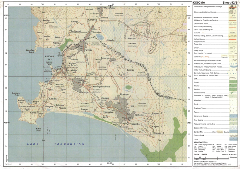
3. Study the map extract of KIGOMA (sheet 92/03) provided and then answer following questions.
(a) Comment on the settlement patterns on the mapped area
(b) Show any two methods which have been used to determine the elevation of the mapped area
(c) By using grid method, find the area of Lake Tanganyika from grid 60 northward of mapped area
(d) Examine four land use of Kigoma area.
4. Describe the following features;
- Snowline
- Moraine
- U-shaped valley
- Glaciated landform
5. Explain four main factors that influence soil formation.
6. Juma wants to use chain survey to carry out his survey work. Explain to him the advantages and disadvantages of using simple chain survey.
7. Study the photograph below and answer the questions that follow.
- Name the crop shown on the Photograph
- Mention the climatic conditions which favor the growth of the crop
- Name at least three regions in Tanzania where this crop is grown in large scale
- With concrete evidence, explain the possible scale of production of the crop as shown on the photograph
- What are economic potentials of this crop for the farmers of this region.
8. The Ministry of Education of United Republic of Tanzania under National Examination Council of Tanzania past five years was in a research about why there was mass failure of pupils in primary schools. This made the government to take sample schools to make a research.
a) As a student who studied a research topic, give only five reasons why the ministry decided to use sample of schools to complete its research instead of taking all primary schools?
b) (i) Briefly explain the tool of data collection that is bias and it suits only to literate people or respondents.
(ii) Which tool needs a researcher to create a friendship atmosphere with a respondent before starting the collection of data?
SECTION B: 30 Marks
Answer all questions in this section
9. Explain the contribution of mining to the economy of Tanzania
10. What lessons can Tanzania learn from tourism industry in Switzerland and Namibia.
11. Most of African countries established birth control and international migration policy as among the methods of controlling rapid population growth. As a form four student, do you think there is any problem of population increase in these countries? Give six points.
FORM FOUR GEOGRAPHY EXAM SERIES 191
FORM FOUR GEOGRAPHY EXAM SERIES 191
PRESIDENT’S OFFICE, REGIONAL ADMINISTRATION AND LOCAL GOVERNMENT
SECONDARY EXAMINATION SERIES,
MID TERM ONE – MARCH-2024
GEOGRAPHY FORM FOUR
Time: 3Hours
Instructions
- This paper consists of sections A, B, and C with a total eleven (11) questions.
- Answer all question in the sections A, B and two (2) questions from section C.
- Section A carries sixteen (16) marks, section B fifty four (54) marks and section C carries thirty (30) marks.
- All writing should be in blue or black pen, except for diagrams that must be drawn in pencil.
- Communication devices and any unauthorized materials are not allowed in the examination room.
- Write your Examination Number on every page of your answer booklet (s
SECTON A (16 MARKS)
- Choose the correct answer from among the alternative given.
- Which stage of research enables the researcher to identify the needs of the society?
- Research output
- Research methodology
- Problem identification
- Research input
- Research design
- Which of the following are major types of variable in a research process
- Qualitative and quantitative
- Dependent and independent
- Null and alternative
- Dependent and quantitative
- Alternative and independent
- The Amazon and Congo basin regions characterized by the same geographical backgrounds to human activities, climate vegetation and relief. What would be the general term for these regions?
- Natural vegetation
- Natural climate region
- Natural well
- Natural resources
- Natural landscape
- Tourist reported enjoying the temperature of Ihefu Wettland in Mbeya at 1500 Metres above sea level, which is 320C. They also planned to travel from Ihefu to Unguja in Zanzibar, which is at the sea level. What might be the temperature experience by the tourist in Zanzibar?
- 230C
- 0.60C
- 90C
- 410C
- 190C
- Measures of Central tendency involve
- Mode, mean and variables
- Mode, arithmetic, mean, data
- Mean, mode, and median
- Arithmetic mean, mode and variable
- Marine erosion is a constant action of
- Wind and running water
- Waves, currents, and tides
- Swash and backwash
- Wave breaks
- Wind
- Downward or upward movement of the earth’s crust are called
- Internal earth movement
- Radical movements
- Lateral movement
- Rational movement
- Lateral movement
- Physical geography deal with ;
- Environment that includes settlement and economic activities
- Trade and business
- The study of earth’s natural features
- Driving and teaching profession
- Man made features
- Weather forecasting is important because it
- Help people get well
- support wild animals
- Help people to plan daily activities
- Show the origin of weather
- Promote people to become rich
- Rainwater which flow on the surface without following a proper channel is called
- Groundwater
- River
- Runoff
- Spring
- Erosion.
- Match the description of environmental issue in list A with their environmental concept in list B, by writing a letter of corresponding response besides the item number in the answer booklet provided
| List A | List B |
|
|
SECTION B
54 MARKS
Answer all questions on this section
- Carefully study the map extract of Liwale (sheet 280/4) and answer the questions that follows
- Giving a reason, identifying the dominant type of rock in a mapped area
- Describe three characteristics of the rock mentioned in (a)
- Briefly describe two possible reasons for the growth of Liwale town
- By using RF scale measure the distance of road in Kilometers from Grid reference 814218 to 809165
- To get solution to the people face in their daily lives pertaining to environmental issues, an expert should conduct a Geographic research. With six points, explain the importance of doing that research.
- Describe social and economic benefits of surveying
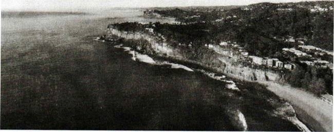
- Study carefully the given photograph and answer the question that follow....(necta2023)
- With two reasons, suggest the type of photograph
- Mention the depositional, emotional and manmade features on the photograph. Give two features for each
- Describe three stages of formation of main marine erosion feature seen at the south eastern part of the foreground
- i)Describe the following features
- Snowline
- Moraine
- U- shaped valley
- Glaciated landform
ii) Distinguish between Corrasion and Corrosion
- (a)How do vegetable adapt to the environmental in the desert areas. Give five points.
(b) Explain four characteristics of vegetation found in desert area
SECTION C.
30 MARKS
Answer two questions from this section
- (a) what is weather
(b) Describe six elements of weather
- Describe the lessons Tanzania can draw form solar energy production in U.S.A
- Discuss the role played by the textile industries in economy of Tanzania.
FORM FOUR GEOGRAPHY EXAM SERIES 179
FORM FOUR GEOGRAPHY EXAM SERIES 179
PRESIDENT’S OFFICE, REGIONAL ADMINISTRATION
AND LOCAL GOVERNMENT
SECONDARY EXAMINATION SERIES
COMPETENCY BASED SERIES
GEOGRAPHY FORM FOUR
MID-TERM EXAMS – AUGUST – 2023
TIME: 3:00 HOURS
Instructions
- This paper consists of sections A,B, and C with total of Eleven (11) questions.
- Answer all questions in Section A and B and any two(02) questions from section C
- Section A carries sixteen (16) marks, Section B carries fifty-four (54) marks and Section C carries thirty(30) marks
- Map extract of KIGOMA (series 92/3) is provided.
- ProgrammableCalculatorandCellularphonesarenotallowedinExaminationroom.
- Write your Examination number on every page of your answer sheet.
SECTION A (16 Marks)
Answer all questions in this section
- For each of the items(i)–(x) choose the correct answer from among the given alternatives and write its letter besides the item number in the answer booklet provided below.
- Raajii wants to carry out a field study on the atmospheric condition suitable for growing maize on his farm land. What is the best weather elements he should consider?
- Rainfall and Wind
- Rainfall and clouds cover
- Moisture and sun shine
- Rainfall and Temperature
- Pressure and humidity
- ThegreenhousegasescandepletetheOzonelayeramongothereffectsofOzonelayerdepletioncanalso cause.
- Good visibility C.Skin cancer
- Clouds formation D.Environmental aspirate E. Glaciations
- The maximum and minimum bulb thermometers are likely to give the same readings, when the air
- Issaturated C.Is wet
- Is not saturated D. Is dry E.Is very hot
- Form one students enjoyed the temperature of Mbagala which was 32⁰C at sea level. They also planned to travel from Mbagala to Kilolo which is 1500M above the sea level. What will be the temperature experienced by the form one students in Kilolo?
- Raajii wants to carry out a field study on the atmospheric condition suitable for growing maize on his farm land. What is the best weather elements he should consider?
A. 23°c B. 9°c C. 17o c D. 0.6°c E. 19°c
- Youareaskedtoselectthetypeofsoilthatisboth,permeableandimpermeabledependingontheextentofsaturation. What will be your selection among the following?
- Loamy B. Silty C. Sandy D. Sedimentary E. Clay
- Dowasa manager wants to construct a well that will serve water supply permanently to the society of Dodoma city. Which layer would your advice to be reached by the pipes to tape the underground water?
- The intermitted zone C. The zone of non-saturation
- The aquifer D.The aquicludes E.The water table.
- Mr. Job grows flowers, vegetable and other plants that cause aesthetic environment, what kind of agriculture is that?
- Aquaculture B.Horticulture C. Garden D. PortcultureE. Botanism
- What would be the name of the sand bar that might joint he Dar-es-salaam and the Zanzibar shores,being constructed by wave action?
- Mudflat B.Spit C. Beach D. Tombolo E. Cuspate foreland
- Your Geography teacher has planned to take you as his Geography students to visit European countries during summer season, which month would you advise him to go?
- January B.September C. DecemberD. March E. June
- A feature you do not see in Tanga Tanzania in the Amboni cavern.
- Stalagmites B.Stalactites C.Levees D. NaturalpillarsE. Underground rivers
- Match the description of desert land forms in listA with the corresponding names in list B by writing the letter of the correct response beside the item number in the answer booklet(s)
| LISTA | LISTB |
|
|
SECTION B (54 MARKS)
Answer all questions in this section
- Carefully study the map extract of Kigoma (sheet 92/3) provided, then answer the following questions:
- Calculate the total distance covered in kilometers if the train is travelling from grid reference 940633 to the center in grid reference 000583 and returned back. (Provide your answer in km)
- With evidence from the map, describe the nature of relief in the mapped area.
- Calculate the area covered by the Lake Tanganyika using the square method. Give your answer in km2
- By giving evidence from the map, name four social economic activities carried out in the area.
- The table below show agricultural production in Tanzania from 2011 to 2013 in “000” Tones.
| CROPS/YEAR | 2011 | 2012 | 2013 |
| Maize | 60 | 75 | 80 |
| Tobacco | 30 | 45 | 55 |
| Coffee | 50 | 60 | 65 |
- Present the data by using comparative bar graphs
- Suggest other two methods which could be used to present the provided data
- Give two advantages of the method used above
- There was a serious conflict between farmers whose plots was nearby each other. They tried to resettle the conflict but they failed and later on they decided to consult the Village Executive Officer to seek the resolution. The Village Executive Officer decided to send the village land resolution team to the field. The team decided to use the method of linear measurement.
- Identify the method of taking measurement used
- List down any four instruments that were used
- If the team consisted of three personnel’s in taking linear measurement. Who are those?
- Describe any three (3) significances of using the method identified in (a) above
- Junior was inside the house where he observed sudden shaking of the floor due to the vibration of the earth’s surface caused by natural tones operating beneath the Earth’s crust. Answer the following questions.
- Name the environmental hazard experienced by Junior?
- What is the instrumental used to measure the intensity of the hazard named in (a) above?
- Briefly explain the four causes of the hazard in (a) above.
- Describe three (3) effects of the Hazard named in (a) above
- Carefully study the photograph below then answer the questions that follow
- Name the type of photograph
- Identify what is seen at the fore ground of the photograph.
- With evidence from the photograph suggest the economic activity that might be taking place in the area.
- Mention any three advantages and three disadvantages of the activity mentioned in (c) above.
- The Ilulu girl’s secondary school located at Kilwa – Lindi prepared the questions in advance in which the same questions were asked to all students who attended the school with a need of securing a chance in the academic year 2023 for form one class.
- Identify the type of interview used by Ilulu secondary school.
- Give out four (4) procedures of conducting interview
- Outline two (2) merits and two (2) demerits of the interview method
SECTION C (30 MARKS)
Answertwo(02)questions from this section
- “Despite of the fact that road transport causes a lot of accidents in Tanzania, most Tanzanians
prefer road transport to Air transport”. With six points justify this statement.
- Large population has advantages of having good number of labor force, discuss sixChallenges associated with rapid population increase in the world.
- A Geography teacher at Kutishana Secondary school taught his students that “Soil has physical,chemical and biological properties”. With facts and vivid example, you as an expert in Geography clarify six (6) properties of soil which were taught by Geography teacher at Kutishana Secondary Schoolto his students.
1
FORM FOUR GEOGRAPHY EXAM SERIES 166
FORM FOUR GEOGRAPHY EXAM SERIES 166
PRESIDENT OFFICE REGIONAL ADMNISTRATION
AND LOCAL GOVERNMENT
SECONDARY EXAMINATION SERIES
COMPETENCE BASED ASSEMENT
GEOGRAPHY FORM FOUR
TERMINAL EXAMS MAY – 2023
013
TIME: 3HOURS
INSTRUCTIONS:
- This paper consists of section A, B and C with a total of eleven (11) questions
- Answer all questions in sections A and B and two questions from section C.
- Section A carries fifteen (16) marks, section B carries fifty five (54) marks and section C thirty (30) marks.
- Map extract of Kigoma (sheet 92/3) is provided.
- Write your examination number on every page of your answer sheet.
SECTION A (16 MARKS)
Answer all questions in this section:
- For each of the item (i – x) choose the best correct answer among the given alternatives and write its letter in your answer sheet.
- Solid heavenly bodies that revolve around the sun mostly between the orbit of mars and Jupiter...........
- Meteors
- Planets
- Asteroids
- Comets
- Which of following layer of the earth that from the ocean floor:
- Core
- Sima
- Crust
- Sial
- One type of mechanical weathering known as Exfoliation is mostly active:
- In limestone areas
- Hot humid region
- In arid region
- At high altitude
- What cause high and low temperature in the desert:
- Lack of vegetation
- Poor cloud cover
- Poor climate
- Harmattan wind
- Soil structure refers to the
- Size of soil particles in the soil
- Arrangement of particles in the soil
- Soil minerals and contents
- Soil PH
- .............. is not a product of denudation in hot region?
- Seif
- Reg
- Grike
- Erg
- Mr Kisimba is keeping a group of Animal in a permanent place, he does not move from place to place with his animals looking for pasture. What is the general term of the livestock keeping category Mr. Kisimba is practicing?
- Nomadic pastoralism
- Semi nomadic
- Transhumance
- Sedentary livestock
- According to approach there are two types of census which are facto and de jure. Do you think which among of the following series of distracters is true about de jure census?
- People how stay in the household for the night are counted
- Is only done for every five years
- Only permanent members of the household are counted
- Is only done for every ten years
- Young African sports club scored first goal against Real De Bamako at 7:10PM in Dar es Salaam (15°W). What time of Burundi (45°E) the goal was scored?
- 11:10AM
- 10:00AM
- 11:10AM
- 12:00AM
- The drainage patterns is formed in an area with an alternative belt of hard and soft rocks;
- Dendritic Drainage pattern
- Centripetal drainage pattern
- Trellis drainage pattern
- Parallel drainage pattern
- Match the item in List A with responses in List B by writing the letter of the correct response beside the item number in the answer booklet provided:
| LIST A | LIST B |
|
|
SECTION B (54 MARKS)
Answer all questions in this section
- Carefully study the following data and answer the questions that follow,
Production.
| YEAR | MAIZE | BEANS | RICE | WHEAT |
| 2004 | 8000 | 1400 | 3320 | 3000 |
| 2005 | 6000 | 2600 | 4000 | 2900 |
| 2006 | 6000 | 4300 | 6000 | 5000 |
| 2007 | 4500 | 4300 | 3850 | 2300 |
| 208 | 3200 | 2850 | 1390 | 1800 |
- Find the mean production of wheat
- Draw the divergence line graph to present wheat production
- Briefly explain four merits of using divergent line graph
- In which year the production of wheat was below the mean
- Form four Geography teacher spent a lot of time on explaining about research topics. You as a student explain how you can conduct a field research
- (a)Explain the function of the following survey tools:
(i)Arrow (ii) Ranging rod (iii) Pegs (iv) Beacon
(b)With aid of diagrams outline five tools used in plane table survey
- (a)The Earth is always affected by different forces within and on the surface.
Briefly explain four forces that occur onto the Earth’s surface
(b) With aid of diagrams briefly explain five intrusive volcanic features
- Study carefully the following photograph and then answer the questions that follows:

- Name the crop shown on the photography
- What is the activity taking place on the photograph
- With the evidence suggest the scale of production on the crop shown
- List down four (4) conditions necessary for the growth of the crop shown on the photography
- Outline four factors that might affect the quality of the photograph given.
- Briefly explain the various problems facing forestry industry in the developing countries. (nine points)
SECTION C (30 MARKS)
Answer two (2) questions from this section
- Study carefully the map extract of Kigoma (sheet 92/3) and then answer the following questions:
- If a train travels from grid reference 910606 to 020579 and then returns back to first station. Calculate the distance covered by the train in km.
- Find the area of Lake Tanganyika in square kilometers
- Describe the settlement pattern found in this Map
- Show three natural physical features found in the map
- Citing evidence from the map, suggest three possible economic activities carried out in the mapped area.
- (a) “Mwanza is among of the fastest growing cities in Tanzania” Briefly explain this situation by using geographical knowledge.
(b) The poor development of rural life has been a major incentive for many young people to leave their rural village, describe why they leave their rural village.
- Luja was talking with her grandmother who believes that the earth’s shape is flat like a table. By using six evidence describe how Luja will prove to her grandmother that the earth is spherical.
FORM FOUR GEOGRAPHY EXAM SERIES 153
FORM FOUR GEOGRAPHY EXAM SERIES 153
PRESIDENT OFFICE REGIONAL ADMINISTRATION AND LOCAL GOVERNMENT
SECONDARY EXAMINATION SERIES
COMPETENCE BASED ASSESSMENT
013 GEOGRAPHY FORM FOUR
MID-TERM EXAMS MARCH – 2023
Time: 3.00 Hours
Instructions
- This paper consists of section A, B and C with a total of ten (10 questions
- Answer all questions in sections A and B and two (2) questions from section C.
- Section A carries fifteen (15) marks, section B fifty (55) marks and section C carries thirty (30) marks
- Programmable calculators, cellular phones and any unauthorized materials are not allowed in the examination room.
SECTION A (16 Marks)
Answer all questions in this section
1. For each of the items (i) – (x), choose the correct answer from among the given alternative and write its letter beside the item number in the answer booklet(s) provided.
- The extensive highland area with more or less uniform summit level bounded by one or more sleep slope side is called
- Hill
- Plateaus
- Residual
- Basin
- Horst
- Which of the following planets is closest to the sun?
- Earth
- Jupiter
- Mars
- Mercury
- Neptune
- The minimum and maximum temperature recorded is used to calculate
- Daily range of temperature
- Annual temperature
- Monthly temperature
- Alcohol temperature
- Relative temperature
- Rain water which flours on the surface without a proper channel is called
- Ground water
- River
- Run off
- Spring
- Well
- If the temperature at asometres is 24°C what is the temperature of Kilimanjaro 5895 metres above the sea level
- 10.24°C
- 34°C
- 5.67°C
- 18.5°C
- 32°C
- The process of peeling off of rock mass is called
- Disintegration
- Weathering
- Mass wasting
- Erosion
- Exfoliation
- Various method are used in mining activities depending on the occurrence of the concerned mineral, easiness of the method and cost. The following are the common methods of mining except
- Strip method
- Placer method
- Open coast method
- Underground method
- Gold, Zinc and Copper
- Juma observed a type of soil with clearly distinguishable horizon which occurs in definite regions of the climate and vegetation. Which or the following type of the soil he observes?
- Intrazonal
- Zonal soil
- Ozonal soil
- Clay soil
- Desert soil
- What geological time scale tool place in Jurassic era?
- Volcanic activity
- Deposition of marine surface sediments
- Ice age mountain
- Down warping of the earth
- Glaciations of East African
- Taifa stars scored a goal against Malawi in Town Y 150E at 4:00p.m. At what time will cementation at town X 63°W will communicate a goal
- 4:47pm
- 10:48a.m
- 11:12am
- 1:48pm
- 6:12pm
2. Match the letter of the correct response beside the item number in the answer sheet provided.
| LIST A | LIST B |
|
|
SECTION B
Answer all questions in this section
3. Study carefully the map extract of Kigoma (sheet 92/3) and then answer the questions that follows)
- Identify the feature that is found in the following grid references
(i)923617 (ii) 945599 (iii) 910596
- Calculate the area of Lake Tanganyika from 570 southward. Give your answer in km2
- What is the length of railway line from grid reference 944633 Eastward. Give your answer in km.
- With evidence Suggest the type of settlement patterns depicted in the map
- By providing evidence, explain three (3) human activities and two (2) social activities that might be taking place in the area.
4. The following table indicates scores of Geography weekly test for some form four students at Mwakalel secondary school in 2021
| Student | Mwantege | Mwaipaya | Mwabete | Mwatu | Mwaka |
| Score | 70 | 50 | 70 | 80 | 40 |
- Present the data by means of divergence bar graph
- Give two merits and two demerits of method used
5. Assume you are a chain survey or expert in one of the villages and you have been assigned a task of measuring a distance of a river from point A to point B
- Which seven steps will you follow to carry out such task?
- Would you ensure the correctness of measurement as you carry out your task?
6. (a)Mention three of metamorphic rocks
(b)Briefly explain importance of rocks
7. Study carefully the photograph below then answer the questions that follow
- Name the type of photograph
- Describe the possible climate of the area
- Suggest four economic activities that might be taking place in the area
- Suggest three regions in Tanzania where the photograph might have been taken
SECTION C (30 Marks)
Answer two (2) questions from this section
8. Explain any six objectives of constructing the Stigler’s gorge hydro-electric power in Tanzania
9. Manufacturing industry plays a great me to the economic development of a country. Clarify any six (6) constraint which face the development of textile industry in Tanzania
10. Plantation is the most common form of Agriculture practiced in Tropical region of Africa, Asia and South America. Justify six (6) characteristics of plantation practiced in these areas
|
|
FORM FOUR GEOGRAPHY EXAM SERIES 139
FORM FOUR GEOGRAPHY EXAM SERIES 139
THE PRESIDENT’S OFFICE MINISTRY OF EDUCATION, REGIONAL ADMINISTRATION AND LOCAL GOVERNMENT
COMPETENCY BASED SECONDARY EXAMINATION SERIES
032/1 GEOGRAPHY FORM FOUR
TIME: 2 HOURS NOVEMBER 2022
Instructions
- This paper consists of section A, B, and C
- Answer all questions in Section A and B and two (02) questions from section C
- Section A carries fifteen (15) marks, Section B carries fifty five (55) marks and Section C carries thirty (30) marks
- Map extract of Babati (Sheet 85/1) is provided
- Programmable Calculator and Cellular phones are not allowed in Examination room.
- Write your Examination number on every page of your answer sheet.
![]() SECTION A: (15 MARKS)
SECTION A: (15 MARKS)
Answer ALL questions in this section
1. For each of the items (i) — (x), choose the answer from among the given alternatives and write its letter in the table provided ![]()
(i) We often see iron made materials get rust and ultimately cause them to decay, what process is responsible for such process?
A. Carbonation ![]()
B. Solution
C. Oxidation
D. Hydrolysis
E. Hydration
![]() (ii) The tourist enjoy the temperature of Zanzibar which was 300C at sea level. They also planned to travel from Zanzibar to Manyara which is 1500 meter above the sea level. What will be the temperature experienced by tourist in Manyara?
(ii) The tourist enjoy the temperature of Zanzibar which was 300C at sea level. They also planned to travel from Zanzibar to Manyara which is 1500 meter above the sea level. What will be the temperature experienced by tourist in Manyara?
A. 230C
B. 90C
c. 190C
D. 60C
![]() E. 170C
E. 170C ![]()
(iii) Jane has been living in Dar es Salaam since 1990 and works as a secretary in the prime Minister's office. In January 2019 she was transferred to a new office in Dodoma region. Identify the type of Jane's movement.
- Migrant
- Emigration
- Immigrat
- Emigrant
- Immigration.
(iv). Japanese felt the earth’s crust moving back and forth and the same to all surrounding environment, help them to familiarize with the phenomena with the most correct type of wave that caused such movement.
- Love waves
- Secondary waves
- Primary
- Raleigh waves
- Surface waves.
(v) Form one students were discussing the different form of precipitation during discussion they failed to identify the form of precipitation which consist of tiny ice crystals deposited on object on the ground. What form of precipitation will you suggest?
- Frost
- Dew
- Hail
- Mist
- Fog.
(vi) River Nile is one of the famous rivers in Africa that flows throughout the year and passes through different countries, suggest to non - geographical taker the type of such river in the following
A. Complex or composite
B. Double regime
C. Perennial
D. Intermittent
E. Ephemeral
(vii)River basin development in Africa has been of great value and one of the most important role of production of Hydro - electric power produced from the Dams constructed across the rivers, help someone to know out of all these dams which one is not from Africa?
A. INGA dam
B. KAINJI dam
C. SEVEN FORKS dam
D. NIAGARA falls
E. SENNAR dam
(viii) Tanzania usually conduct national census after every ten years and it is very important exercise as it entails the total number of people in the country, their socio economic status and making of future demographic plans, as a smart form four student remind as the year when the second census was conducted after independence.![]()
A. 1967
B. 1984
c. 2012
D. 2002
E. 1988
(ix) The study tour of form three students from Dar es Salaam to Mbeya gave them the nice experience of see the different geographical features as they travelled the soil reflection differed from whiteness, blackness and so on, their teacher Mr. Tumsifu told them the changes that they saw in soil was result of organic matter, mineralogical contents, and demand them to recall the term responsible for the process among the following
A. Soil porosity
B. Soil PH
C. Soil color
D. Soil texture
E. Soil matter
(x) You are asked to help a form two students who failed to identify the types of the forest found in the area with low temperature. What type of the forest will you ![]() suggest among the following?
suggest among the following?
A. Tropical rain forest
B. Coniferous forest
C. Equatorial forest
D. Deciduous forest
E. Mediterranean forest
2. Match the descriptions of soil in the LIST A with response of soil formation in the LIST B by writing the letter of the correct response beside the items number in the answer booklet provided
| LIST A | LIST B |
|
|
SECTION B: (55 MARKS)
Answer all questions from this section
3. Study carefully the map extract of KOROGWE (sheet 129/2), then answer the following questions
(a) Describe the relief of the mapped area
(b)Examine the settlement patterns of the area
(c)Express the scale of the map into statement scale
(d)Calculate the area of the whole map of Korogwe in km2 by using Grid squares
(e)With evidence from the map mention four economic activities done in the area
4. Jema afraid for the disintegration and movement of the fragment which move down from the mountain and need to know the process occur on that area
![]() (a) Name the process seen by Jema
(a) Name the process seen by Jema
(b)Describe how animals cause the process mentioned in (a) above
(c)List five process of chemical weathering
5. Teacher asked form four students to do research on the problems caused by the earth quakes in their village.
(a)Name two research tools will be used by students
(b) Give four advantages of each tool
(c) Explain four challenges of each tool
6. Form three students of Rudewa secondary school would like to conduct a simple chain survey around their netball ground.
(a)Describe three benefits of doing a simple chain survey
(b)Mention essential tools needed on that process .
7. Carefully study the photograph below then answer the question that follow.
(a) Write two evidences suggest the type of the photograph.
(b)Many people prefer going to water bodies to refresh after a long hard working day. However many cannot identify features around them, as an expert help them to identify three (3) main geomorphic features shown on the photograph
(c)Elaborate in short any two (2) process responsible for the formation of the named features.
(d)Name three (3) economical resources which can be found in the area
SECTION C: (30 MARKS)
Answer two (2) questions from this section
8. On 23rd August, 2022 has been announced as a CENSUS DAY by Tanzanian Government. All Tanzanian citizens must be enumerated
(a) Describe five objectives of conducting census in our country
(b) Explain three limitations of census in African countries
9. Nowadays "Royal Tour" is the common word in Tanzania, it attracts and announces our tourist attractions in the country. By using concrete examples explain five (5) negative effects of Tourism in East Africa.
10. Form four students were given assignment of visiting rural areas of their ancestors to learn different matters relating to socio — economic and cultural values of society of their origin. Among the surprising fact they discovered was the presence of high birth rate in rural areas as compared to urban areas, where fertility rate is low. Present the findings to your teacher by stating six reasons for high birth rate in rural areas
FORM FOUR GEOGRAPHY EXAM SERIES 132
FORM FOUR GEOGRAPHY EXAM SERIES 132
THE PRESIDENT’S OFFICE MINISTRY OF EDUCATION, REGIONAL ADMINISTRATION AND LOCAL GOVERNMENT
COMPETENCY BASED SECONDARY EXAMINATION SERIES
GEOGRAPHY-SEPT 2022
FORM FOUR
INSTRUCTIONS
- This paper consists of sections A, B and C with a total of ten (10) question.
- Answer All questions in sections A and B and any two (2) questions from section C.
- Map extract of LINDI is provided
- Cellular phones are NOT allowed in the examination room.
- Write your Examination number on every page of your answer booklet (s)
SECTION A (15 MARKS)
PHYSICAL AND MATHEMATICAL GEOGRAPHY
- For each of the items (i) – (x) choose the correct answer from the given alternatives and write its letter besides the item number.
- The sun is a star of average size and brightness from Earth, the sun appears as round yellow object in the daytime sky. At night we see other stars they appear as tiny points of night. Why does the sun appear large than stars that we see at night?
- Earth’s Atmosphere filters out light from other stars making them appear large
- The sun is close to the earth than other star making the sun appear large
- Star light bend as it pass planets making stars appear smaller
- Day light bend brightness the sun, making it appear larger
- The sun is the planet which follow after the Earth there fore if is very close to it.
- Mrs. Kandonga was shocked the way the earth’s crust shaking resulting to large displacement of materials located on the ground. As a form four students having the knowledge of about the event, what is general statement could you describe the epicenter as source/origin of the shaking of the ground?
- The epicenter is the point on the Earth’s surface just above the location where movement on the fault begin.
- The epicenter is at Caltech in paradena an seismograph are located
- The epicenter is a place on the fault where interests the surface
- The epicenter is the point on the fault’s surface within the Earth where the rapture on the fault begin
- Non above.
- If a geography teachers; Mr. Hassan takes you up to Kilimanjaro Mt. What features would you observe?
- Shield volcano and strato volcano
- Strato volcano and caldera
- Strato volcano and crater
- Dumulo dome and caldera
- Dyke and sills
- The form four students were told by their geography teacher to identify the second layer of the earth’s crust. The response of the students was
- Sial
- Sima
- Mantle
- Core
- Gutenburg gap
- James was given explanation about drainage pattern which looks like a tree with its branches. Which of the following patterns is looking like a tree with its branches?
- Trellised
- Dendritic
- Centripetal
- Radial
- Annular
- If the temperature at 500 metres where the tourists start climbing mount Rugwe is 20°C. What will be the temperature when they reach 2000 meters above sea level?
- 10°C
- 5°C
- 11°C
- 12°C
- 15°C
- If you were a geographer, how could you name the process in which a river renews its erosion in its valley?
- Regime
- Rejuvenation
- Capture
- Cavitation
- Non-of the above.
- If the time at town X 15°E is 12:00 noon, what could be the longitude of 8:00 a.m?
- 15°W
- 30°E
- 45°W
- 30°W
- 45°E
- The Amazon and Congo basine are regions characterized with the same geographical 10 human activities, climate, vegetation and relied. What could be the general term for these regions?
- Natural region
- Natural resources
- Natural vegetation
- Natural landscape
- Natural climate
- Lucia was crossing Rufiji River and accidentally dropped her school bag in the river. Lucia cried as she observed her bag being pulled by the river water the India Ocean. What could the bag named in relation to the river action?
- River erosion
- River transportation
- River load
- River meander
- River bed
- Match the items in List A with responses in List B by writing the letter of the correct response beside the item number in the answer booklet provided.
| LIST A | LIST B |
|
|
SECTION B: (55 Marks)
- Carefully study the map extract of LINDI provided and then answer the following questions
- Convert RF scale given from the map into statement scale.
- A tax driver was moving from Mchinga to Lindi where there is falting station. Find the distance covered in Kilometers
- Calculate the area covered by the forests south of grid line 120.
- With evidences, suggest four economic activities of the people living in the area.
- Giving two evidence from the map. Name the type of climate experienced in this area.
- Carefully study the data in the table below showing importation of motor vehicles from Europe in 2009, and answer the questions that follows:
| Name of vehicle imported | Number of motor vehicle |
| JEEO | 430 |
| BENZ | 192 |
| BMW | 108 |
| RIMOUSSENE | 70 |
- Draw a divided circle to represent the data
- Show three advantages and two disadvantages of the method you have used in (a) above.
- In 2022 form four students from Matemanga secondary school heard about loss of biodiversity existing in Ngorongoro game reserve located at Arusha region Via television and Radio, Geography teacher and reference books from library. They decided to conduct research finally they submitted their report to the head of school.
- Suggest the statement of the problem for their research
- What were the main three (3) objectives of their research?
- Identity two sources of that research problem.
- Elaborate four possible research tools he would use during data collection.
- There was land conflict between two farmers of a certain village in Namtumbo District. The village officers decided to invite a survey team and Cadastral officer to measure and demarcate the boundaries of the two farms. The invited officers decided to use chain/tape surveying to settle the problem.
- Explain three (3), procedures they use during the surveying process.
- Describe (5) instrument they might used in surveying the farmer’s farm.
- Briefly outline the three advantages of the surveying method used above.
- Study the following photograph and answer the questions that follow.
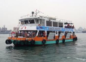
- Identify the type of photograph. Give two reasons to support your answer
- What type of transport is shown in the photograph, and name the kind of vessel shown in the photograph?
- Explain four advantages of transport shown on the photograph
- Identity four main functions of the area.
SECTION C (30 MARKS)
- The government of Tanzania has been struggling to achieve economic development and one of the approach that has been proposing is transport and communication. Explain the significance of transportation in developing in developing countries. Give six points
- When Maganga, a geography teacher was teaching form four students about small scale agriculture, he said “small scale agriculture has been greatly affect bt the rapid population explosion”. As a form four student show how does rapid population explosion affects small scale agriculture.
- From the experience that you have acquired from geographical studies, examine eight factors which lead to the growth of settlement in different parts of the country.
FORM FOUR GEOGRAPHY EXAM SERIES 117
FORM FOUR GEOGRAPHY EXAM SERIES 117
THE PRESIDENT’S OFFICE, MINISTRY OF EDUCATION, REGIONAL ADMINISTRATION AND LOCAL GOVERNMENT
COMPETENCE BASED SECONDARY EXAMINATION SERIES
GEOGRAPHY TERMINAL EXAMINATION
FORM FOUR -2022
INSTRUCTIONS
- This paper consists of section A, B and C with a total of ten (10) questions.
- Answer all questions in section A and B and any two (2) questions from section C.
- Map extract of Kigoma (sheet 92/3) is provided.
- Programmable calculators, cellular phones and unauthorized materials are not allowed in the examination room.
- Write your examination number on every page of your answer booklet(s).
SECTION A
Answer all questions in this section
1 For each of the items (i — x), choose the correct answer from among the given alternatives and write its letter in the answer bracket (s) provided.
(i) The Earth have different evidences that proves that the Earth is spherical. What do you think that this is one among those evidences?
- The four seasons
- The lunar eclipse
- The revolution of the Earth
- The Earth rotation
- The eclipse of the sun
(ii) If the scale of a map is 1: 50,000 what will be the actual ground distance of a river with 18cm on a map?
- 91m
- 2km
- 18000km
- 4Km
- 900,000 km
(iii) The forceful emission of hot water from the ground into the atmosphere is known as
- Geyser
- Well
- Hot spring
- Pond
- Dyke
(iv) If the temperature at 950 metres is 240 C What is the temperature of Kilimanjaro 5895 metres above the sea level?
- 10.240 C
- 340 C
- 5.670 C
- 18.50 C
- 320 C
(v) A drainage pattern which works likc a trcc with its branches is called
- Radial
- Dendritic
- Centripetal
- Annual
- Trells
(vi) A vertical feature formed out of the solidification of magma within the Earth's crust is called
- Localita
- sill
- lopolith
- Dykc
- Phacolith
(vii) The process of peeling off of rock mass is called
- Disintegration
- Weathering
- Mass wasting
- Erosion
- Exfoliation
(viii) Various methods are used in the mining activities depending on the occurrence of the concerned mineral, easiness of the method and cost. The following are the common methods of mining except
- Strip method
- Placer method
- Open cast method
- Underground method
- Gold, zinc and copper
(ix) The following arc the element of weather
- Soils, clouds, dew, humidity, rainfall
- Pressure, clouds, sunshine, humidity, winds
- Fog, barometer, humidity, pressure, air mass
- Pressure, humidity, soil, fog, rainfall
- Clouds, sunshine, pressure, humidity, thermometer
(x) Form of metamorphism which affects large area with the influence of pressure only
- Contact metamorphism
- Dynamic metamorphism
- Local metamorphism
- Thermal metamorphism
- Diastrophism
2. Match the items in List A with the responses in list B by writing the letter Of the correct responses beside the item number in the answer booklet provided.
| LIST A | LIST B |
| (i) Fineness and coarsened of soil particles (ii) Removal of materials from the surface of the land (iii) Vertical section of the soil to the underlying rocks (iv) Status of soil with respect to amount elements necessary for plants (v) Residues that have decomposed and mixed with soil mass |
|
SECTION B ( 55 Marks)
3. Study carefully the map extract of Kigoma (sheet 92/3) and then answer the questions that follows.
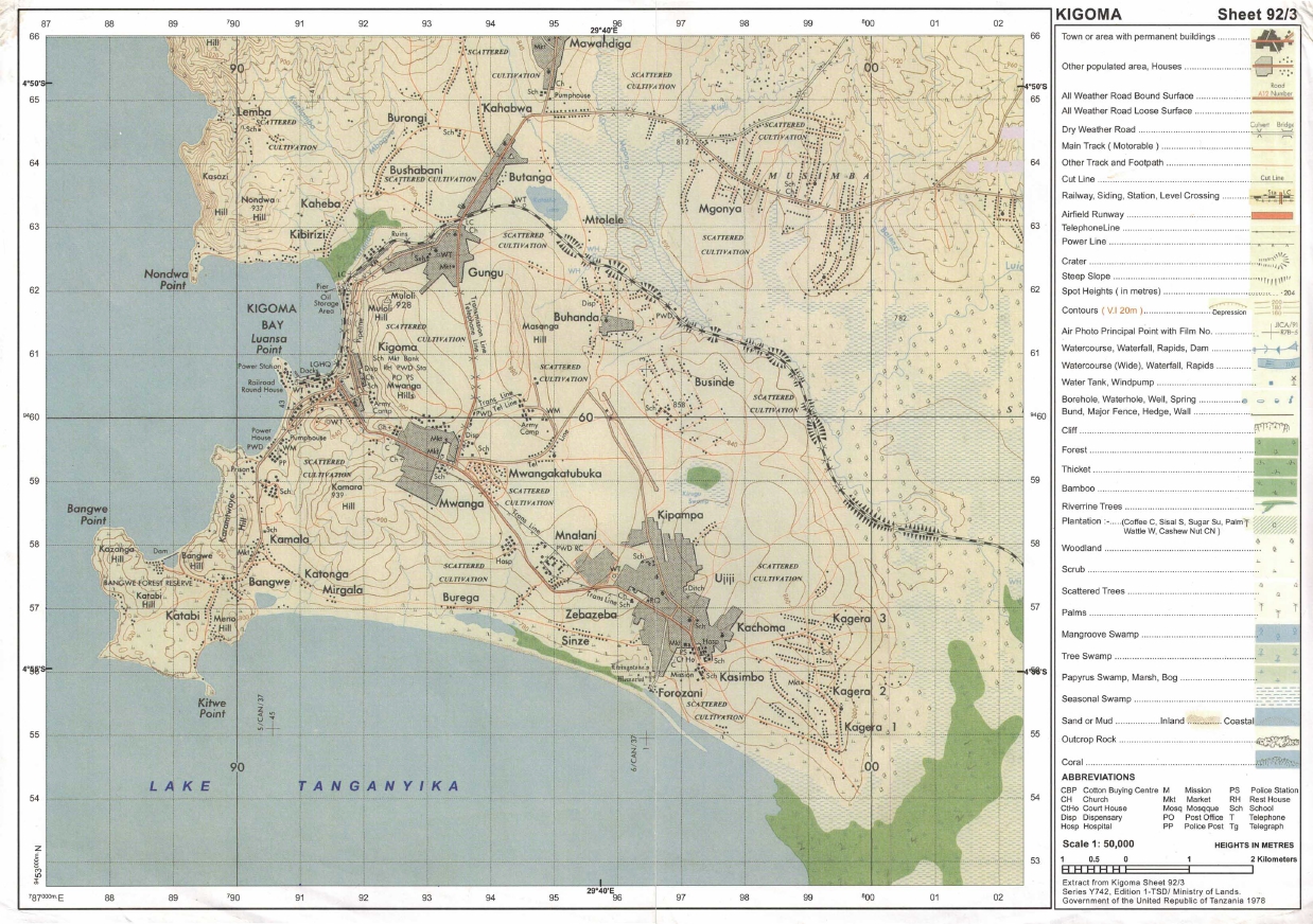 |
(a) Identity the features that found in the following grid references
- 923617
- 945599
- 910596
(b) Calculate the area of lake Tanganyika from 570 Southward. Give your answer in Km2
(c) What is the length of the railway line from grid reference 944633 Eastward. Give your answer in Km.
(d) With evidence suggest the type of settlement patterns depicted in the map.
(e) By providing evidences, explain three (3) human economic activities and two (2) social activities that might be taking place in the area.
4. The following table indicates scores of Geography weekly test for some form four students at Mwakalel Secondary School in 2021.
| Student's name | Mwantege | Mwaipya | Mwaitabete | Mwakatundu | Mwakabute |
| Sares | 70 | 50 | 70 | 80 | 40 |
(a) Present the data by means of divergence bar graph
(b) Give two merits and two demerits of the methods used.
5. (a) Mary is a good cartographer, she intends to produce a contoured map of Morogoro. What type of survey method would you advise her to apply.
(b) A part from producing contoured maps what is the other significance of the survey you have mentioned in (a) above.
(c) Mention and explain uses of any three instruments which are used in a method you mentioned in (a) above.
6. Kibwena is studying in a boarding school at Kigoma but his home is in Tarime District where he used to observe several conflicts between farmers and pastoralists. In his third week in school he heard through, the radio that, a farmer was killed by the pastoralist in his home village he decided to conduct research about the conflict.
(a) Suggest the statement of the problem for his research.
(b) Identify two sources of that research problem
(c) Elaborate four (4) possible research tools he could use during data collection,
(d) Explain three significance or conducting that research.
7. Carefully study the following photograph and answer the questions that follows:-
 |
(a) By giving two reasons, identify the type of photograph
(b) With evidences, suggest two climates of the area
(c) Name the feature found at the background of the photograph.
(d) Give one reason, why the major trees shown in the photograph have no leaves?
(e) Why the images of trees at the fore ground seems to be large than those trees at the back ground even if are of the same size?
SECTION C (30 Marks)
Answer two (2) questions from this section.
8. Development of transport and communication system takes place fast where there is enough capital. But lack of capital leads to poor and slow development of transport and communication. Therefore the government should invest more capital to constructing good infrastructure because of the major importance that are found within this sector. Give six importance of transport and communication to any nation.
9. With examples describe cultural beliefs which influence high fertility or birthrate in developing countries lake Tanzania as your reference (provide six (6) points).
10. "Manufacturing industry plays a great role to the economic development of a country?' clarify any six (6) constrains which face the development of textile industry in Tanzania.
FORM FOUR GEOGRAPHY EXAM SERIES 99
FORM FOUR GEOGRAPHY EXAM SERIES 99
THE PRESIDENT’S OFFICE
MINISTRY OF EDUCATION, REGIONAL ADMINISTRATION AND LOCAL GOVERNMENT
COMPETENCE BASED SECONDARY EXAMINATION SERIES
GEOGRAPHY TERMINAL EXAMINATION
FORM FOUR -2022
INSTRUCTIONS
- This paper consists of sections A, B and C with a total of ten (10) questions.
- Answer all questions in sections A and B and any two (2) questions from section C.
- Map extract of Mkomazi (Sheet 109/1) is provided.
- Programmable calculators, cellular phones and unauthorised materials are not allowed in the examination room.
- Write your Examination Number on every page of your answer booklet(s).
SECTION A (15 Marks)
Answer all questions in this section.
1. For each of the items (i) — (x), choose the correct answer from among the given alternatives and write its letter besides the item number in the answer booklet provided.
(i)Due to the spinning effect of the earth, air currents do not travel in straight line. The term used to describe this situation is
- Deflection
- Reflection
- Deflaction
- Abrasion
- Direction
(ii)If the time at place X 45°E is 10:00am what will be the time at place Y 45°W?
- 6:00am
- 10:00am
- 4:00pm
- 4:00am
- 10:00pm
(iii)The temperature at place K whose altitude is 200metres is 20°C. What will be the temperature at mount H whose altitude is 3400metres?
- 39.2°C
- 0.8°C
- 19.2°C
- 10.8°C
- 21°C
(iv)When a river system is not related to the structure of the region where it flows, the system is said to show a drainage pattern known as
- Trellis
- Superimposed
- Rejuvenated
- Dendritic
- Normal
(v)Which of the following combined processes makes mass wasting?
- Soil creep
- Mud flow
- Granular disintegration
- Rock falls and landslides
- Joint and crack
(vi)Which of the following features are produced by water action on the desert?
- Yardangs and playas
- Sand-dunes and Canyons
- Alluvial fans and zeugens
- Canyons and playas
- Yardangs and sand-dunes
(vii)The rocks which contain iron are easily weathered through the process called
- Hydrolysis
- Hydration
- Oxidation
- Carbonation
- Solution
(viii)Soil with clear distinguishable horizons which occur in definite region of climate and vegetation are known as
- Intrazonal soil
- Clay soil
- Azonal soil
- Zonal soil
- Silt soil
(ix)Plants with long roots, thorny stems, needle-shaped leaves, wax or hair found in;
- Hot desert
- Mediterranean region
- Equatorial region
- Tropical grass lands
- Mountain region
(x)A good example of igneous rocks is
- Gneiss
- Basalt
- Gabbro
- Marble
- Slate
2. Match the items in LIST A with the responses in LIST B by writing the letter of the correct response beside the item number in your booklet provided.
| LIST A | LIST B |
|
|
SECTION B (55 MARKS)
Answer all questions in this section
3.Study the map extract of Kasamwa (sheet 32/4) then answer the questions that follow:
- By using the given R.F. Scale, measure the distance of all-weather road in Kilometers from grid 330851 to grid 430924
- Through giving evidence, explain any four (4) economic activities that might be taking place in the area
- Find the bearing of Bungwe Hill grid reference 430820 from Chabulongo Hill grid reference 365915
- Name the methods used to show the relief features on the map
- Name the main features found in the following grid reference
- 315850
- 430930
- 360860
- 360860
- 320915
4.Study the following data for vehicles moving along Morogoro-Dodoma, and then answer the following questions
| Period | Dustan | Land Rover | Isuzu | Toyota | Others |
| 8:30 – 10:30am | 100 | 150 | 300 | 240 | 80 |
| 2:30 – 4:30pm | 40 | 60 | 70 | 20 | 50 |
| 6:30 – 8:30pm | 120 | 130 | 90 | 140 | 120 |
| TOTAL | 260 | 340 | 460 | 400 | 250 |
- Present the data above by means of a Pie chart
- Describe the advantages and disadvantage of the method you have used in (a) above (2 points each case)
5(a)What is plane table survey?
(b)Mention the composition of the chain survey team and state the role of each member.
(c)Using diagram, demonstrate how to conduct chain survey in an area with a small hill which cannot be walked around easily
6(a)Point out five (5) objectives of doing research in Tanzania
(b)Explain the meaning the following concepts as applied in research
- Reconnaissance
- Questionnaires
- Data analysis
- Systematic sampling
- Hypothesis formulation
- Primary data
7.Carefuly study the photograph below and answer the questions that follows.
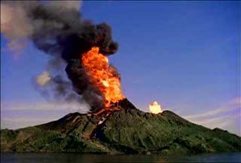
- With two (2) reasons suggest the type of photograph shown above?
- Name the natural activity taking place in the photograph
- Mention any three (3) extrusive features formed by the activity in 7(ii) above
- State any three (3) positive impacts and any three (3) negative impacts of the activity taking place in the photograph
SECTION C (30 MARKS)
Answer two (2) questions from this section
8.Population in Sub-Sahara Africa is unevenly distributed. Discuss (six points)
9. (a) Distinguish between large scale and small-scale farming. (Three points)
(b) What are the advantages of large-scale farming over small scale farming? (Three points)
10.The Earth spins on its own axis from West to East and make one complete rotation after 24 hours. What are the outcomes of this motion? (Four points)
FORM FOUR GEOGRAPHY EXAM SERIES 86
FORM FOUR GEOGRAPHY EXAM SERIES 86
THE PRESIDENT’S OFFICE
MINISTRY OF EDUCATION, REGIONAL ADMINISTRATION AND LOCAL GOVERNMENT
SECONDARY EXAMINATION SERIES
GEOGRAPHY MID TERM EXAMINATION
FORM FOUR- MARCH/APRIL -2021
Time: 3 Hours
Instructions.
SECTION A (15 Marks)
Answer All questions in this section.
TIME 3:00 HRS
INSTRUCTIONS
- This paper consists of section A, B and C with a total often (O) questions.
- Answer all questions in section A and B and two (2) questions from section C

- Section A carries fifteen (15) marks; section B fifty-five (55) marks AND section C carries thirty (30) marks.
- Map extract of MKOMAZI (Sheet 109/1).
- Programmable calculators, cellular phones and any unauthorized material are not allowed

- Write your fully name on every page of your answer
SECTION A: 15 MARKS
Answer all questions in this section
l. For each of the following item (i) —(x), choose the correct answer from the given alterative and write its letter In the booklet(s) provided.ssss
- The sun IS surrounded by a layer of gas that has boiled from its surfaces, -
- Corona
- Colona
- Satellite
- Milky way
- Galaxy
- Form tour students from Kibo secondary school visited KIA weather station, but suddenly all of them were shocked to see a white wooden box mounted on 4 legs. What are the instruments found in it?
- Maximum and minimum thermometer
- Hygrometer, wet bulb and rain gauge
- Drv bulb thermometer and barometer
- Six's thermometer and wind vane
iii) Minimum thermometer and wind speed which of the following occurs when the moon's shadow cast over the earth0
- Solar eclipse
- Lunar eclipse
- Aphelion
- Summer solstice
- E) Equinoxes
- A geographer watched national geographic session on TV at Baffin Bay (750W, 780N) at 7:30pm
Tuesday at what time and day will people in Mpanda (450E, 060S) be watching the TV9
- 8.30pm Tuesday
- 3:30pm Wednesday
- 1 1:30pm Wednesday
- 12:30pm Tuesday
- 3:30am Wednesday
- Form four students of Kibo secondary school made simple Investigation around Lake
Victoria with their geography teacher, arc observed that, Lake Victoria is the best example of, -
- Up warping
- Volcanic activity
- Wave action
- Down warping E) Rift valley
- When describing the internal structure of the earth crust which layers, is the following which layer of the earth forms the ocean floor
- Sial
- Core
- Crust D) Mantle E) Sima
- The tourists enjoyed the temperature of Mwanza which was 320C at sea level. They also planned to travel from Mwanza to Arusha which is 1500M above sea level. What will be the temperature experienced by the tourists in Arusha?
A) 90C
- 0 60C
- 170c
- 190C
- 230C
![]() Philemon was living near the mountain. Within a time; he noticed the bending of trees and fences down ward the slope. Identify the type process occur.
Philemon was living near the mountain. Within a time; he noticed the bending of trees and fences down ward the slope. Identify the type process occur.
A) . Mud slide
B). Soil slide
- Soil creep
- Rock fall
- Soil erosion
x) The form three students were told that, soil has certain biological chemical and physical characteristics. What is the general term for these characteristics?
- Soil particles
- Soil properties
- Soil formation
- Soil profile
- soil fertility
- Match the descriptions of the type of agriculture in LJ.ST A with the correct type of agriculture in LIST B by writing the letter of the correct response beside the item number in the answer booklet(s) provided

|
| LIST A | LIST B |
|
|
|
|
SECTION B: 55 MARKS
Answer all questions from this section
- Study the map extract of MKOMANZI (Sheet 109/1) provided then answer die following questions

- Calculate the forest area by grid square in km2

- In which ways the map scale has been expressed?
- With reasons identify the major type of transport found in the mapped area?
- With evidence from the map, describe two geomorphic processes that have shaped the mapped area.
- With two reasons, identify the type of climate in the area
- Calculate the forest area by grid square in km2
- Mr. Lufega is a very good farmer but he does not know how to present the production of his crops by using graphs although he always likes to record the production of each year The table below shows his records of production of some crops as from 2010 to 2013 in "000" tones

| Crops/year | 2010 | 201 1 | 2012 | 2013 |
| Cotton | 65 | 35 | 60 | 70 |
| Wheat | 25 | 30 | 20 | 25 |
| Sisal | 50 | 60 | 45 | 45 |
- Help Mr. Lufega to present the data by using a grouped bar graph
- Explain to Mr. Lufega three advantages Of using the above method of data presented (iii) Comment on the trend of production of Mr. Lufega
- Luciana visited her friend at Mwibate village, she noticed that her friend wanted to conduct survey that she wanted to conduct survey by measuring horizontal distance between two points but there was a pond between the identified points and her friend didn't know how to do any more.
- Name the method of land survey appropriate to her survey.
- Name the method that Luciana would advise her friend to use so as to avoid the pond.
- Draw a diagram showing the method named in 5 (b) above.
- Outline five tools that might be used in the method named in 5(a) above.
- Ngorongoro conservation Authority (NCA) is globally recognized as environmental friendly by allowing socio-interaction of the human being and wildlife within the crater. The Rhino species was nowdays disappearing due to their demand in Asian markets. Nakumbuka as a member of Malihai club from Kibo secondary school was interested to conduct a research on it.
- What will be the research title? o
- Describe the methods used to get information.
- List down two (2) advantages of each method used.
- State three (3) uses of research outputs
-

 Study the photograph provided below and then answer the questions that follow
- With reason, identify the type of photograph
- What is the name of the plant shown on the photograph?
- With reason, suggest the climate does the plant named in 7(b) above belong?
- Outline four adoptive mechanisms of the named plant in 7(b) above to its environment.
SECTION C: 30 MARKS
- "The ideally census must cover the whole country and all people residing in the country must be counted." Suppose you have given a task to educate your society about census, why would you tell people that, it is very important for Tanzania government to conduct census? (Explain five (5) points•
- Recently the world is facing a very dangerous pandemic disease (COVID 19) which affects people and their economy. Explain six (6) effects of the pandemic to the tourism sector in Tanzania.
- Human activities enable the livelihood but on other hand they destroy the environment. Justify this statement with six (6) points on the environmental problem resulted by human activities that normally do.
FORM FOUR GEOGRAPHY EXAM SERIES 79
FORM FOUR GEOGRAPHY EXAM SERIES 79
THE UNITED REPUBLIC OF TANZANIA PRESIDENT’S OFFICE
REGIONAL ADMINISTRATION AND LOCAL GOVERNMENT
FORM FOUR GEOGRAPHY MID TERM EXAMINATION-2021
TIME : 3HRS
SECTION A (25 Marks)
1. For each of the following items (i) - (x) choose the correct answer and write its letter beside the number
- Downward or upward movement of the earth’s crust are always given the name as …..
- Internal earths movement ( )
- External earths movements
- Radial movements
- Lateral movements
- ………………………. is a bowl shaped depression at the mouth of a volcano or geyser
- Hot springs
- Lava ( )
- Crater
- Caldera
- Endogenic geomorphic processes includes one among the following.
- Faulting, earthquake, weathering, folding and mass wasting.
- Folding, mass wasting, river action and faulting
- Joints, volcanism, mass wasting and folding. ( )
- Folding, earthquake, faulting and volcanism
- Farmers at Mkombozi village invited Farm officer to give them knowledge on the kind of good soil for growing maize plant. One of the knowledge he provided was about rocks permeability. Assume you are the one invited, what would you tell the farmer about permeability of rock?
- The ability of the rock to hold water.
- The ability of the rock to allow water to pass through.( )
- The rate at which water enter the rock.
- The ability of the rock to allow water to enter it.
- The core comprises mainly of …………………………
- Silica and magnesium
- Silica and aluminum ( )
- Nickel and iron
- Iron and magnesium
- In de jue census, among the following can be done
- People who stay in the house hold for the night are counted
- Is only done after five years
- Only permanent members of the house hold are counted ( )
- I only done after every ten years
- ………………………………. Is a chart used for dating the history of the earth including its rocks?
- Carbon 14
- Periodic table ( )
- Geological time scale
- Measurement chart
- The earth’s sphere where life takes place is called …………………………
- Hydrosphere ( )
- Atmosphere
- Biosphere
- Barrysphere
- A geography teacher was teaching her student that, the earth is inclined in its orbit at which the intensity of sun rays reach different part of the earth varies and cause the earth to experience seasonal weather changes.By relating with the revolution of the earth, what result might occur on the earth?
- Day and night ( )
- Deflection of wind and ocean currents.
- Season of the year.
- High tides and low tides
- John was conducting a research on his first undergraduate degree. Through his research he found that, when someone cross the International Date Line eastward one among the following occur.
- The day become longer than night
- One day is turned back
- Greenwich mean time is recorded
- Time is gained by 4 minutes at every 15 hours ( )
- Match the following items LIST A and that of LIST B
| LIST A | LIST B |
|
|
SECTION B (55 marks)
Answer all questions in this section.
3. Study the map extract of Mpwapwa (sheet 163/4) and answer the following questions.
- At which part of the equator is Mpwapwa located (give one reason)
- Determine the size of the area covered by the forest found between Eastings 150 and 220 and South ofNorthings 900
- What type of vegetation is dominating in the area.
- Suggest four methods used to represent relief features in the mapped area
- Give the bearing of Veternary Research Institute grid reference (224995) to Mpwapwa Teachers Training college grid reference (203978)
- With evidence from the map suggest four social services found aroundgrid reference 218983
- Carefully study the data given on the table below and then answer the questions that follow:
| Class | Frequency |
| 20 - 24 25 - 29 30 - 34 35 - 39 40 - 44 45 - 49 50 - 54 55 - 59 60 - 64 | 3 7 8 12 9 6 4 1 0 |
(a) Find the:-
- Mean
- Mode
- Briefly explain four types of line graph
- (a) The ministry of educationof united republic of Tanzania under National Examination Council past five years, was in research about why there was mass failure of pupils in primary schools. This made the government take sample of schools to make their research. As a student who studied a research topic, give only five reasonwhy the ministry decided to use sample of schools to complete its research?
(b) Briefly explain the following
- Primary data.
- Secondary data.
- (a) Name three kind of obstacles that hinders taking direct measurement during surveying.
(b)Explain five main sources of mistakes during chain survey.
- Study the following photograph and answer the questions that follow.
- Name the crop shown on the photograph. (2mark)
- What is the activity taking place on the photograph.(2mark)
- With one evidence, suggest the scale of production of the crop shown. (3marks)
- List down four conditions necessary for the growth of the crop shown on the photograph. (4 marks)
- Outline four factors that might affect the quality of the photograph given. (4marks)
SECTION C (30 Marks)
Answer two questions in this section
- ‘’The ideally census must cover the whole country and all people residing in the country must be counted’’. Suppose you are given a task to educate your society about census. Why would you tell people that, it is very important for Tanzanian government to conduct census?(Explain five reasons).
- Plantation is the most form of agriculture practiced in tropical region of Africa, Asia and South America. Justify six characteristics of plantations practiced in these areas.
- Discuss six efforts that Tanzania must adopt to make tourism industry very potential for our national development.
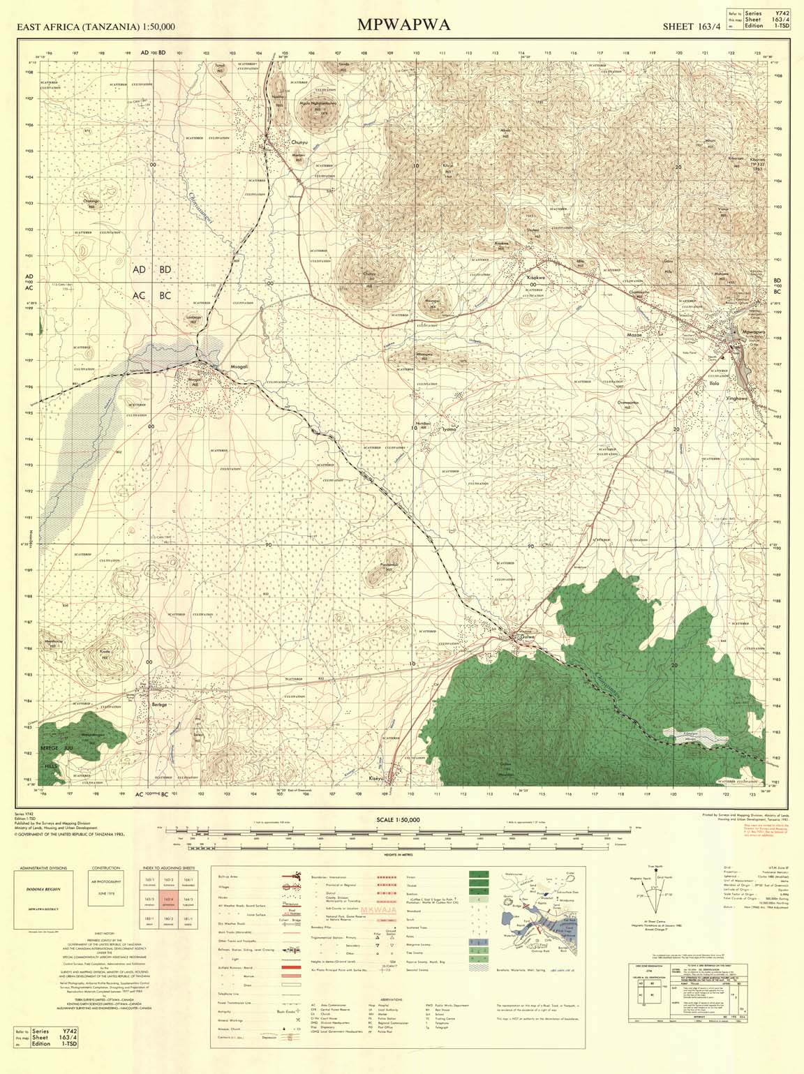 |
FORM FOUR GEOGRAPHY EXAM SERIES 70
FORM FOUR GEOGRAPHY EXAM SERIES 70
THE PRESIDENT’S OFFICE
MINISTRY OF EDUCATION, REGIONAL ADMINISTRATION AND LOCAL GOVERNMENT
SECONDARY EXAMINATION SERIES
GEOGRAPHY MID TERM EXAMINATION
FORM FOUR- AUG/SEPT -2021
Time: 3Hours
Instructions.
- This paper consists of section A, B and C with a total of 10 questions
- Answer all questions in section A and B and two questions from section C.
- Section A carries 15 marks, section B 55 marks and section C 30 MARKS
- Map extract sheet for Kigoma sheet 92/3 is provided.
- Programmable calculators, cellular phones and any other unauthorized materials are not allowed in examination room.
- Write your number on every page of your answer booklet.
SECTION A (15 Marks)
Answer All questions in this section.
(i)The intensity of an earthquake is measured by an instrument called:
A. epicentre
B.chronometer
C. seismography
D. Richter scale
E. hygrometer
(ii)Tides are highest:
A.during the eclipse
B.during the aphelion
C.during the equinox
D.during the day and night throughout the year
E.at the poles
(iii)Which one among the following features occurs in a glaciated lowland region?
- Esker
- Cirque
- Pyramidal peak
- Hanging valley
- Arete
(iv)Plants with long roots, thorny stems, needle shaped leaves, wax or hair are found in:
- the Mediterranean region
- hot deserts
- tropical grasslands
- the equatorial region
- the monsoon region
(v) The magnitude of an earthquake refers to:
- effects produced by the earthquake
- large amplitude waves known as L-waves
- point at which earthquake originates
- total amount of energy released
- point on the earth surface above the focus
(vi) When two forces act away from each laterally, they are called
- lateral forces
- orogenic forces
- vertical forces
- compressional forces
- tensional forces.
(vii) The earth’s shape is a flattened sphere which is called
- ekman spiral
- geoid
- globe
- galtax
- spherical.
(viii)Which of the following types of lakes does not occur from depositional factor?
- Playa
- Tarn
- Ox-bow
- Delta
- Lagoon
(ix)The name given to a boundary that demarcates solid materials from the molten mantle is:
- asthenosphere
- Gutenberg
- mohorovic
- mesosphere
- core
(x)The crust is sometimes referred to as:
- lithosphere
- hydrosphere
- troposphere
- mesosphere
- tropopause
2, Match the responses in LIST B with the phrases inLIST Aby writing the letter of the correct response beside the item number.
| LIST A | LIST B |
| (i)Are lines of glacial deposits along the sides of valleys (ii)A tidal formed as a result of an earthquake or volcanic eruption (iii)Small particles of condensed water at the lower part of the atmosphere (iv)Winds blowing from horse latitudes to the Equatorial belts (v)A well developed surface of a limes one region |
|
SECTION B (55 Marks)
Answer all questions in this section.
3. Study the map extract of Kigoma sheet 92/3 and answer the following questions.
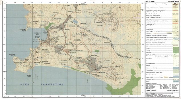
(a) Outline the importance of scale in a map.
(b) Measure the distance of the railway line.
(c) Calculate the area of Lake Tanganyika.
(d) What factors have influenced the location of Kigoma town?
(e) Explain the main socio-economic activities carried out in the area.
3. The data below show the enrolment of Form Five students at Kilimo Secondary School from 1980 - 1985.
|
| 1980 | 1981 | 1982 | 1983 | 1984 | 1985 |
| No. of Students | 100 | 150 | 175 | 200 | 225 | 300 |
(a)Present the data by divergent bar graph.
(b)What are the advantages and disadvantages of this method?
(c) Name three alternative ways of presenting the data.
5. Giving examples, explain how you can conduct a field research.
6.(a) Define the term rock
(b) Give economic importance of rock
7. Study carefully the photograph provided and answer the following questions:
(a) Explain the traditional methods used for clearing the vegetation as seen in the photograph.
(b) State the type of vegetation found in the area.
(c) What are the impacts over the environment of this activity at the local and national level?
(d) Determine the weather condition at the time the photograph was taken.
SECTION C (30 Marks)
Answer two (2) questions from this section.
8. Describe six contributions of cash crops production ot the economy of United States of America.
9. “Agriculture achievements in China have been brought about by good Government policy only.” Discuss.
10. Explain the factors that influence the exploitation of mineral resources.
FORM FOUR GEOGRAPHY EXAM SERIES 60
FORM FOUR GEOGRAPHY EXAM SERIES 60
THE PRESIDENT’S OFFICE
MINISTRY OF EDUCATION, REGIONAL ADMINISTRATION AND LOCAL GOVERNMENT
SECONDARY EXAMINATION SERIES
GEOGRAPHY TERMINAL EXAMINATION
FORM FOUR-2021
Time: 3Hours
Instructions.
- This paper consists of section A, B and C with a total of 10 questions
- Answer all questions in section A and B and two questions from section C.
- Section A carries 15 marks, section B 55 marks and section C 30 MARKS
- Map extract sheet for Kigoma (Series Y742 sheet 92/3), is provided.
- Programmable calculators, cellular phones and any other unauthorized materials are not allowed in examination room.
- Write your number on every page of your answer booklet.
SECTION A (15 Marks)
Answer All questions in this section.
1. For each of the items (i) - (x), choose the correct answer from among the given alternatives and write its letter beside the item number.
(i) Which one of the following, by origin and composition is not a form of igneous rocks?
- Sill
- Gypsum
- Lava plain
- Volcano
(ii) One of the following features is a product of weathering:
- Earth pillar
- Gully
- Lilly
- Hot springs
- Soil creep.
(iii) One of the following features is a product of weathering:
- Earth pillar
- Gully
- Lilly
- Hot springs
- Soil creep.
(iv) The following are instruments used in chain and tape survey:
- Barometer, pegs, notebook, compass
- Tape measure, chain, cross staff, anemometer
- Chain, arrows, ranging poles, altimeter
- Arrows, ranging poles, pegs, chain
- Cross staff, notebook, chain and plane table.
(v) When the river flows in its long profile it performs the following geological activities:
- Moves fast and can carry everything on the earth’s surface
- Erodes, transports and deposits weathered materials
- Meanders and forms ox-bow lakes throughout the profile
- Does three functions such as abrasion, solution and attrition
- Acts as agent of weathering and erosion along the profile.
(vi) If the location of a point on a map is given by grid reference 365490, then
- 365 are Degrees
- 365 are Longitudes
- 490 are Northings
- 490 are Eastings
- 365 are Northings
(vii) Which of the following is the effect of mass wasting?
- Frost action
- Interlocking spur
- Rock fall
- Exfoliation
- Rock disintegration.
(viii) The columns of clay capped by boulders formed due to rain action are known as:
- soil creep
- gullies
- land slide
- earth pillars
- cuesta
(ix) A time accepted throughout a time zone of 15° longitude is known as
- local time
- noon time
- greenwich mean time
- sun time
- standard time.
(x) Which sequence of the following processes is necessary for the formation of rainfall?
- Condensation, cooling and evaporation
- Evaporation, cooling and condensation
- Evaporation, sedimentation and cooling
- Evaporation, condensation and cooling
- Evaporation, cooling and sedimentation.
2. Match the descriptions of karst region features in Column A with the corresponding feature in Column B by writing the letter of the correct answer beside the item number in the answer booklet provided.
| Column A | Column B |
|
|
SECTION B (55 Marks)
Answer all questions in this section.
3. Study the printed map extract of Kigoma (Series Y742 sheet 92/3), then answer the following questions:
(a) By using the vertical scale of 1cm to 20m, draw a cross section from grid reference 91057 to grid reference 932620 and determine its Vertical Exaggeration (V.E).
(b) With vivid evidence from the map, mention the major types of transport shown in the area.
(c) Apart from fishing activities, use concrete evidence to name other economic activities taking place in the area.
(d) In which hemisphere is the mapped area located? Give evidence for your answer.
4. (a) Using examples from East Africa, describe each of the following types of volcanoes:
(i) Active Volcano
(ii) Dormant Volcano
(b) Using a well labelled diagram, explain how each of the following features were formed:
(i) Composite Volcano
(ii) Volcanic plug.
(c) Explain four negative effects of vulcanization
5. Carefully study the hypothetical data presented below showing the export of crops from Tanzania.
The Export of Crops in Tonnes
| Year | Cloves | Sisal | Cotton |
| 1990 | 4000 | 3500 | 7000 |
| 1991 | 2500 | 2000 | 4500 |
| 1992 | 3500 | 1500 | 6000 |
| 1993 | 6000 | 1000 | 8500 |
| 1994 | 6500 | 1500 | 9000 |
(a) Present the data using compound bar graph.
(b) Explain two advantages and disadvantages of compound bar graph.
5. (a) What is a research problem?
(b) Name four sources of research problem.
(c) Explain four characteristics of research problem.
3. (a) The diagram below represents some volcanic features. Use it to answer the questions below.
Name the features marked P, Q, R and S.
P— Sill (1 mark) Q — Vent
R — Batholith
S— Lopolith
(b) Identify the main characteristics of the ocean water.
(c) Give three factors that influence wave deposition.
SECTION C (30 Marks)
Answer two (2) questions from this section.
8. Analyse eight problems associated with growth of urban settlement.
9. Describe six contributions of cash crops production of the economy of United States of America.
10. Explain eight characteristics of shifting cultivation.
FORM FOUR GEOGRAPHY EXAM SERIES 51
FORM FOUR GEOGRAPHY EXAM SERIES 51
THE PRESIDENT’S OFFICE MINISTRY OF EDUCATION, REGIONAL ADMINISTRATION AND LOCAL GOVERNMENT
SECONDARY EXAMINATION SERIES
FORM FOUR GEOGRAPHY MID TERM EXAMINATION
Time: 3Hours
Instructions.
- This paper consists of section A, B and C with a total of 10 questions
- Answer all questions in section A and B and two questions from section C.
- Section A carries 15 marks, section B 55 marks and section C 30 MARKS
- Map extract sheet for Sikonge(sheet 137/2) is provided.
- Programmable calculators, cellular phones and any other unauthorized materials are not allowed in examination room.
- Write your number on every page of your answer booklet.
SECTION A (15 Marks)
Answer All questions in this section.
- The layer of the earth that forms the ocean floor is
- Mantle
- Sial
- Sima
- Core
- Crust
- Which of the following is not a cause of desertification in Tanzania?
- Deforestation
- Urban growth
- Shift cultivation
- Over fishing
- Bush fire
- The following factors makes Switzerland Attractive to tourists except
- Wildlife
- Good infrastructure
- Best hospitality
- Political stability
- Package tours
- Which of the following occurs when the moon shadow cast over the earth?
- Solar eclipse
- Lunar eclipse
- Equinoxes
- Summer solstice
- Aphelion.
- The upper section of the river is also called
- Young stage
- gradient stage
- old stage
- nature stage
- deposition stage
- It refers to the seasonal variation of water volume in river valley
- river capture
- river rejuvenation
- River regime
- river erosion
- river capture
- Sand dunes and ripples shares similar features in this way
- Have crastinal characteristics
- are formed from ground moraine
- Originated from river activities
- are formed by depositional activities
- are formed in deserts
- Rift valley lakes are normally deep and narrow, a good example is
- Lake Baringo and Nakuru in Kenya
- Lake Victoria in Tanzania
- Lake Volta in Ghana
- Qattara Depressions in Egypt
- Lake chad
- A basin which consists of layers of permeable rock lying between two layers of impermeable rock is called.
- Well
- Spring
- artesian basin
- artesian well
- rill
- Which of the following is involved in deforming the structure of the earth?
- gravitation force
- denudation
- deforestation
- overgrazing
- earth quake.
2. Match the description of the types of agriculture in LIST A with the correct type of Agriculture in LIST B by writing the letter of the correct answer beside the item number in answer booklet provided.
| LIST A | LIST B |
|
|
3. Carefully study the map extract of sikonge provided then answers the questions that follow
- Calculate the total distance covered in kilometers if the car was travelling from Sikonge town (732787) to Lyombakuzoa church (755765) and turned back to Sikonge town.
- With evidence from the map, describe the nature of relief in mapped area
- Calculate the gradient from grid reference 835846 to 782786
- Find the highest point on the given map and give its grid references and direction
- State the general direction of the slope of the land in the mapped area.
4. Read carefully the hypothetical data representing each crop production in Tanzania in “000” tones, and then answer the questions after it.
| YEARS | COFFEE | COTTON | TEA |
| 1980 | 200 | 150 | 250 |
| 1981 | 150 | 200 | 150 |
| 1982 | 130 | 100 | 100 |
a) Mention 5 methods which the given data may be presented.
b) Present the data above through comparative line graph.
c) Why there is a decrease of Tea production year after year (3-reasons).
5. a) What is meant by Research
b) Briefly explain the importance of research to students. (4 points)
c) Differentiate between Primary data and secondary data.
6. a) Define these terms as applied to surveying technique.
- Levelling
- Chaining
- Forward Bearing
- Booking
b) What are shortcomings of using a “chain” as a measuring instrument where surveying a place (5 points)
8. Study this photograph and then answer the next questions.
Questions
i) What type of photograph is this?
ii) Suggest the natural feature seen at large
iii) Suggest the limitation of the types of transport displayed on photograph-(2 limitation)
iv) Write two significances of the area
v) Suggest two places where the photo might have been taken
SECTION C (30 MARKS)
8. Tanzania is endowed with large virgin lands for farming but yet there is a problem of food shortage, suggest 6 causes for food shortage in Tanzania.
9. Analyze 6 benefits of livestock keeping in East African countries
10. Migration is caused by push and pull factors. Using six points, Justify this statement.
FORM FOUR GEOGRAPHY EXAM SERIES 47
FORM FOUR GEOGRAPHY EXAM SERIES 47
THE PRESIDENT'S OFFICE
MINISTRY OF REGIONAL GOVERNMENT AND LOCAL GOVERNMENT
PRE-NATIONAL EXAMINATION SERIES-1
GEOGRAPHY FORM-4
2020
TIME: 3:00 HRS
Instructions
- This paper consists of sections A, B and C with a total of ten (10) questions.
- Answer all questions in sections A and B and any two (2) questions from section C.
- Map extract of Mkomazi (Sheet 109/1) is provided.
- Programmable calculators, cellular phones and unauthorised materials are not allowed in the examination room.
- Write your Examination Number on every page of your answer booklet(s).
SECTION A (15 Marks)
Answer all questions in this section.
1. For each of the items (i) — (x), choose the correct answer from among the given alternatives and write its letter besides the item number in the answer booklet provided.
(i) Which of the following layers of the earths interior is made up of sima and sial?
- Biosphere
- Hydrosphere
- Asthenosphere
- Lithosphere
- Barysphere
(ii) Senegal National team scored a goal at 2:00 pm in Senegal (1500 W). At what time at Burundi (300 E) the goal was scored?
- 2:00 am
- 10:00 am
- 4:00 am
- 10:00 pm
- 12:00 am
(iii) Which of the following is the process of wearing down the rock surface by wind where the load becomes cutting tools?
- Deflation
- Attrition
- Abrasion
- Corrasion
- Hydration.
(iv) The renewed power of erosion of a river is called.
- river capture
- river erosion
- river rejuvenation
- river meanders
- river basin.
(v)Prediction of the state of atmosphere in a region for 24 to 48 hours is known as
- weather elements
- weather report
- weather instrument
- weather station
- weather forecasting
(vi) Deposition of soil materials removed from one horizon to another is called
- Convex sided
- Concave sided
- Gentle sided resistance
- Steep sided resistant
- Steep sided non resistance.
(vii) The excessive strong wind blowing across an extensive ocean surface is called
- Tsunami
- Ocean currents
- Storm s urge
- Hurricane
- Wind.
(viii) Rainfall that occurs when the air moves towards a hill or a mountain is called
- cyclonic
- orographic
- convectional
- showers
- typhoon.
(ix) An active state of decomposition caused by soil microorganism is called
- organic matter
- soil water
- mineral matter
- soil air
- soil components.
(x) The name given to earthquake waves that travel within a crust is
- focus
- epicentre
- seismic
- surface waves
- body waves.
2. Match the items in List A with the responses in List B by writing the letter of the correct response beside the item number in the answer booklet provided.
| LIST A | LIST B |
| (i) A mass of magma which has emerged on the earth’s surface. (ii) A wall like feature formed when magma cuts across a bedding plane. (iii) A sheet of magma which lies along a bedding plane. (iv) A very large mass of magma which often forms the root of a mountain. (v) A dome-shaped feature formed when magma push up the overlaying layers. |
|
SECTION B (55 Marks)
Answer all questions in this section.
3. Study the map extract of Mkomazi (Sheet 109/1) and then answer the following questions:
- By using the given RF scale, measure the distance of river Pangani in kilometres from grid reference 910771 to 910826.
b. Describe relief of the area.
c. With reasons, identify two types of rocks found in the map.
d. Name the major way used to show the height of the land in the mapped area.
e.Using a vertical scale of lcm to represent 50m, draw an annotated cross section from grid reference 960820 to 910880 and mark Ruvu river basin and the main trucks.
4. (a) Explain the meaning of the standard deviation.
(b) Study the following data showing the age of the Primary School pupils at Tumaini Primary School and answer the questions that follow: 15, 8, 7, 6, 12, 5, 14 and 13.
(i) Determine the range and median of the age of the pupils.
(ii) Calculate the standard deviation.
5. Form three students at Nguvumali secondary school would like to conduct a simple chain survey around their school compound and measure the height of the big gully near the headmaster’s office. Describe the significance of survey in Tanzania
6. (a) What is meant by sampling techniques as used in research?
(b) Briefly explain the following concepts as they are applied in sampling:
(i) A sample
(ii) Random sampling
(iii) Systematic sampling
(iv) Stratified sampling
(c) Outline the procedures of conducting an interview.
7. Study the photograph given below and then answer the questions that follow:
(a) With two reasons, identify the type of the photograph.
(b) Identify the type of the settlement pattern seen on the photograph.
(c) Name two economic importances of the area shown on the photograph.
(d) Explain two social and environmental problems that are likely to occur in the area.
SECTION C (30 Marks)
Answer two (2) questions from this section.
8. Describe seven problems associated with rapid urbanization.
9. Describe five measures to control floods to the environment.
10. Analyse six potentials of the Rufiji river basin.
FORM FOUR GEOGRAPHY EXAM SERIES 31
FORM FOUR GEOGRAPHY EXAM SERIES 31
THE PRESIDENT’S OFFICE MINISTRY OF EDUCATION, LOCAL ADMINISTRATION AND LOCAL GOVERNMENT
GEOGRAPHY- POST-MOCK- EXAMINATION-JUNE
FORM FOUR
Time 3:00 Hours JUNE 2020
Instructions
- This paper consists of sections A, B, and C.
- Answer all questions in sections A, and B two questions from section C.
- Map extract of Ilonga (Sheet 265/2) is provided.
- Credit will be given for the use of relevant diagrams.
- Calculators and Cellular phones are not allowed in the examination room.
- Write your Examination Number on every page of your answer booklet(s)
SECTION A
(i) Which of the following layers of the earths interior is made up of sima and sial?
- Biosphere
- Hydrosphere
- Asthenosphere
- Lithosphere
- Barysphere
(ii) Senegal National team scored a goal at 2:00 pm in Senegal (1500 W). At what time at Burundi (300 E) the goal was scored?
- 2:00 am
- 10:00 am
- 4:00 am
- 10:00 pm
- 12:00 am
(iii) One of the factors for soil formation is
- organic matters
- mineral matters.
- time.
- water.
- air.
(iv) Which among the following is a heavenly body that possesses and transmits its own light?
- Moon
- Sun
- Earth
- Astreroid
- Planet.
(v) Which among the following features are produced by wave erosion?
- A Geo, wave cut platform and stack
- Blow hole, sea arch and levee
- Sea arch, beach and stump
- Beach, spit and bars.
- Tombolo, meander and cliff.
(vi) Prediction of the state of atmosphere in a region for 24 to 48 hours is known as
- weather elements
- weather report
- weather instrument
- weather station
- weather forecasting
(vii) Which of the following instrument is used to measure maximum and minimum temperature?
- Barometer
- Thermometer
- Anemometer
- Sixs thermometer
- Hydrometer.
(viii) The process of changing granite to gneiss rock is known as
- sedimentation
- vulcanism
- denudation
- metamophism
- exfoliation.
(ix) Zeugens and yadangs differ in
- position of the rock strata
- position of the rock in the slope
- place of formation
- colour of the rock on which they are formed
- the type of the rock on which they are formed.
(x) Which of the following features produced by ice action is the result of both erosional and depositional activities?
- Arête.
- Hanging Valley.
- Erratic.
- Cirque.
- Roche Mountonee.
2. Match the descriptions of karst region features in Column A with the corresponding feature in Column B by writing the letter of the correct answer beside the item number in the answer booklet provided.
| LIST A | LIST B |
|
|
SECTION B (55 Marks)
Answer all questions in this section.
3. Study the map extract of Ilonga (Sheet 265/2) and answer the following questions:
a. By using square method, determine the area North western of Luhombero river from grid reference 570963 to 644034.
b. With evidence from the map, name six symbols which have been used to inteprete a given map.
c. Give the direction of Iputi to Ilonga.
d. Describe the settlement pattern of the mapped area.
e. Giving evidences, mention five possible economic activities which might take place in the mapped area.
4. (a) Give three differences between interview and observation.
(b) Outline four merits of library research.
5. Explain five importance of survey in daily life.
6. (a) Define compound bar graph.
(b) Study carefully the table below on hypothetical data about cash crops production (in ‘000 tonnes) in East Africa in the year 2000, then answer the questions that follow. Find this
| Country | Crops | ||
| Coffee | Tea | Cotton | |
| Kenya | 2200 | 2000 | 1800 |
| Uganda | 1700 | 700 | 800 |
| Tanzania | 1300 | 1900 | 2300 |
(i) Draw compound bar graphs to represent the data provided.
(ii) Outline four merits of using compound bar graph.
7. (a) Describe discordant drainage system.
(b) Explain the process of river transport and describe four ways in which a river transports its load.
SECTION C (30 Marks)
Answer two (2) questions from this section.
8. Describe seven problems associated with rapid urbanization.
9. Analyse six potentials of the Rufiji river basin.
10.Elaborate seven ways of managing industrial pollutants to the environment.
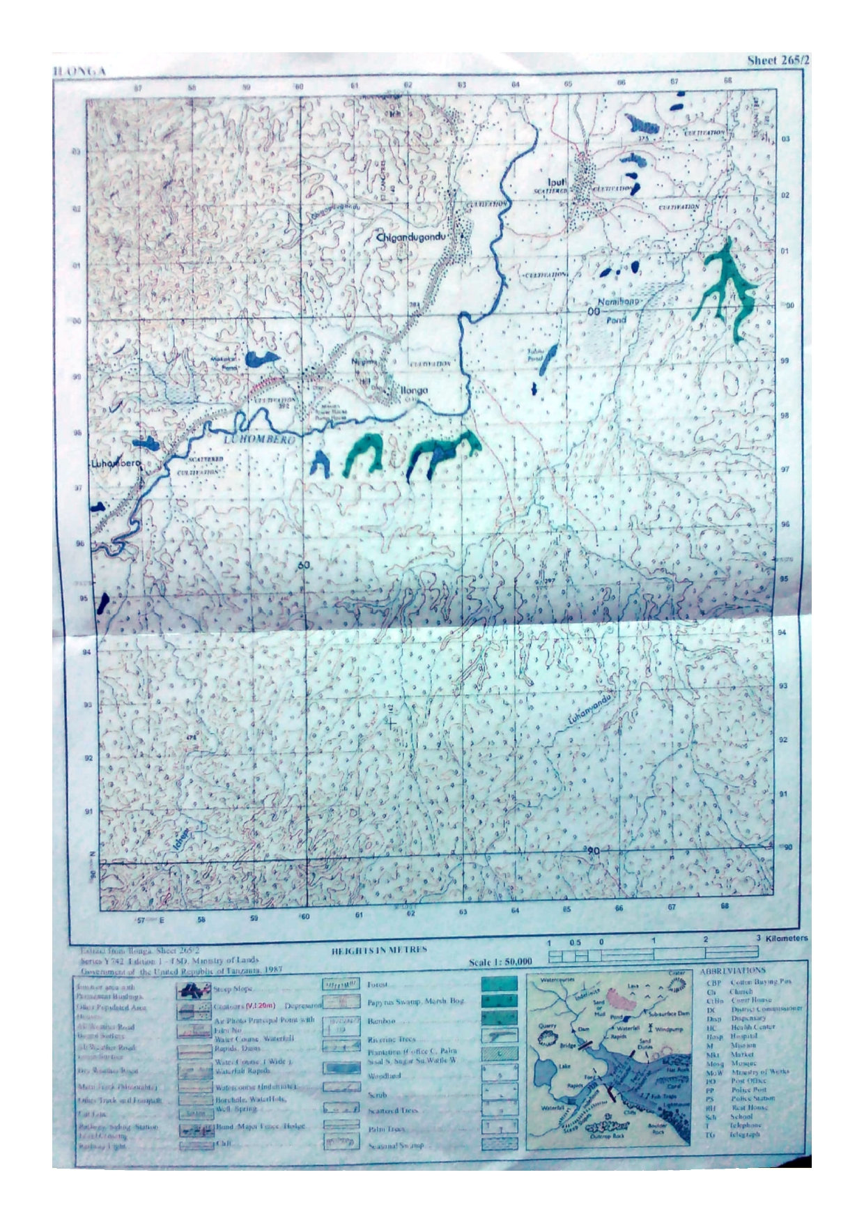
FORM FOUR GEOGRAPHY EXAM SERIES 22
FORM FOUR GEOGRAPHY EXAM SERIES 22
THE PRESIDENT’S OFFICE MINISTRY OF EDUCATION, LOCAL ADMINISTRATION AND LOCAL GOVERNMENT
GEOGRAPHY- TERMINAL- EXAMINATION-MAY
FORM FOUR
Time 3:00 Hours MAY 2020
Instructions
- This paper consists of sections A, B, and C.
- Answer all questions in sections A, and B two questions from section C.
- Map extract of Arusha (Sheet 55/3) is provided.
- Credit will be given for the use of relevant diagrams.
- Calculators and Cellular phones are not allowed in the examination room.
- Write your Examination Number on every page of your answer booklet(s)
SECTION A. 15 MARKS
1. For each of the items (i) (x), choose the correct answer from among the given alternatives and write its letter besides the item number in the answer booklet provided.
(i) Which of the following instrument is used to measure maximum and minimum temperature?
- Barometer
- Thermometer
- Anemometer
- Six's thermometer
- Hydrometer.
(ii) Which among the following is an extrusive volcanic feature?
- Crater
- Laccolith
- Batholith
- Sills
- Dykes.
(iii) Prediction of the state of atmosphere in a region for 24 to 48 hours is known as
- weather elements
- weather report
- weather instrument
- weather station
- weather forecasting
(iv) Which of the following is another name for Savanna climate in Africa
- Tropical maritime.
- Warm temperature maritime.
- Tropical grassland.
- Warm temperature desert.
- Cool temperate western margin.
(v) Day reaches its maximum length on 21st June in
- Southern hemisphere
- Northern Hemisphere
- Arctic Circle
- Polar region
- Tropic of Capricorn.
(vi) The excessive strong wind blowing across an extensive ocean surface is called
- Tsunami
- Ocean
- Storm surge
- Hurricane
- Wind
(vii) Which of the following is not a factor influencing temperature of a place?
- Aspect
- Ocean current
- Altitude
- Eclipse
- Length of a day
(viii) Which one of the following conditions is important for the growth of coral reefs?
- Warm and muddy river water
- Warm and muddy sea water
- Warm and clear sea water
- Warm and clear tape water
- Warm and clear river water.
(ix) A cirque is
- an arm-chair shaped depression on a glaciated lowland area
- an arm-chair shaped depression on the sides of a glaciated mountain
- an arm-chair shaped depression in the desert areas
- an arm-chair shaped valley in glaciated areas
- an arm-chair shaped depression on the plateau.
(x) A channel diverging from the main river and flowing into the sea or a lake by a separate mouth is called
- tributary
- stream
- distributary
- river basin
- water shade
2. Match the items in List A with the responses in List B by writing the letter of the correct response besides the item number in the answer booklet provided.
| LIST A | LIST B |
|
|
SECTION B. 55 MARKS
3. Carefully study the following statistical graph showing coffee production (in tonnes) in Tanzania, from 2011 to 2014 and answer the questions that follows

(a) Describe the type of statistical graph used.
(b) Analyse the five procedures involved in constructing such a statistical graph.
(c) Giving two points, comment on the differences in coffee production shown in the graph.
(d) Give three advantages of presenting data by using the type of graph described in 3(a).
4. (a) Describe the following research terms:
- Population.
- Random sampling.
- Literature review.
(b) (i) Define secondary data.
(ii) Give four merits of secondary data.
5. Carefully study the map extract of Arusha (Sheet 55/3) provided then answers the questions that follow.
(a) Describe the relief of the mapped area.
(b) Giving evidences, mention the major means of transport shown in a map.
(c) Change the scale of the map into a statement scale.
(d) Measure the length of the road from grid reference 378314 to grid reference 480276 in kilometres.
(e) With evidence from the map, identify three social services which are found in this area.
6. Study the photograph provided below and then answer the questions that follows:

(a) Name the type of photograph.
(b) Give three characteristics of the type of photograph in (a) above.
(c) Explain four possible factors which may cause the loss of biodiversity in the photograph.
(d) Give two economic importance of the area.
(e) In three points, describe the importance of the vegetation shown in the area.
7. (a) Explain the meaning of the standard deviation.
(b) Study the following data showing the age of the Primary School pupils at Tumaini Primary School and answer the questions that follow: 15, 8, 7, 6, 12, 5, 14 and 13.
(i) Determine the range and median of the age of the pupils.
(ii) Calculate the standard deviation.
SECTION C. 30 MARKS.
Answer two questions from this section.
8. Describe five uses of population data to a country.
9. Explain six problems associated with expansion of cities in Tanzania.
10. Describe seven problems associated with rapid urbanization.
11. Examine seven effects of climatic change in the world.
FORM FOUR GEOGRAPHY EXAM SERIES 16
FORM FOUR GEOGRAPHY EXAM SERIES 16

DOWNLOAD LEARNING HUB APP NOW

SORRY, YOU CAN'T VIEW THIS MARKING SCHEME PLEASE DOWNLOAD LEARNING HUB APP FROM PLAYSTORE TO GET FULL ACCESS TO ALL MARKING SCHEME!!
Click Here To Download Learning Hub Tanzania App
SAMAHANI, HUWEZI KUFUNGUA MAJIBU YA MTIHANI, TAFADHALI PAKUA APP YA LEARNING HUB TANZANIA ILI KUWEZA KUFUNGUA MAJIBU YA MITIHANI KATIKA TOVUTI HII!!
Bofya Hapa Kupakua App Ya Learning Hub Tanzania
Hub App
 For Call,Sms&WhatsApp: 255769929722 / 255754805256
For Call,Sms&WhatsApp: 255769929722 / 255754805256  MATOKEO YA KIDATO CHA VI 2026
SECONDARY REGIONAL EXAMS
PRIMARY REGIONAL EXAMS
FORM VI NECTA REVIEWS
FORM IV NECTA REVIEWS
FORM II NECTA REVIEWS
STD VII NECTA REVIEWS
STD IV NECTA REVIEWS
SECONDARY EXAMS SERIES
PRIMARY EXAMS SERIES
PRIMARY SUBJECT NOTES
SECONDARY SUBJECT NOTES
SECONDARY TOPICAL EXAMS
SECONDARY TOPICAL QUESTIONS
PRIMARY TOPICAL QUESTIONS
PRACTICAL EXAMS & NOTES
SECONDARY REGIONAL EXAMS
DOWNLOAD SUBJECT NOTES
SCHEMES OF WORK (PRIMARY & SECONDARY)
LESSON PLAN
SECONDARY LOG BOOKS
PRIMARY LOG BOOKS
LITERARY WORKS / UCHAMBUZI VITABU
METHALI ZOTE ZA KISWAHILI
Vitendawili Vya Kiswahili
FORM VI RESULTS 2024
FORM FIVE SELECTION 2024
Matokeo KIDATO CHA II 2024
Matokeo Darasa IV 2024
MATOKEO KIDATO CHA IV 2023
FORM ONE SELECTION 2024
FORM VI RESULTS 2023
Matokeo Darasa IV 2022
MATOKEO YA KIDATO CHA VI 2026
SECONDARY REGIONAL EXAMS
PRIMARY REGIONAL EXAMS
FORM VI NECTA REVIEWS
FORM IV NECTA REVIEWS
FORM II NECTA REVIEWS
STD VII NECTA REVIEWS
STD IV NECTA REVIEWS
SECONDARY EXAMS SERIES
PRIMARY EXAMS SERIES
PRIMARY SUBJECT NOTES
SECONDARY SUBJECT NOTES
SECONDARY TOPICAL EXAMS
SECONDARY TOPICAL QUESTIONS
PRIMARY TOPICAL QUESTIONS
PRACTICAL EXAMS & NOTES
SECONDARY REGIONAL EXAMS
DOWNLOAD SUBJECT NOTES
SCHEMES OF WORK (PRIMARY & SECONDARY)
LESSON PLAN
SECONDARY LOG BOOKS
PRIMARY LOG BOOKS
LITERARY WORKS / UCHAMBUZI VITABU
METHALI ZOTE ZA KISWAHILI
Vitendawili Vya Kiswahili
FORM VI RESULTS 2024
FORM FIVE SELECTION 2024
Matokeo KIDATO CHA II 2024
Matokeo Darasa IV 2024
MATOKEO KIDATO CHA IV 2023
FORM ONE SELECTION 2024
FORM VI RESULTS 2023
Matokeo Darasa IV 2022


