THE UNITED REPUBLIC OF TANZANIA PRESIDENT’S OFFICE REGIONAL ADMINISTRATION AND LOCAL GOVERNMENT(KATAVI, MBEYA, NJOMBE, RUKWA, RUVUMA AND SONGWE

FORM FOUR ZONAL MOCK II EXAMINATION GEOGRAPHY
TIME: 3:00 HOURS YEAR: 2025
INSTRUCTIONS
- This paper consists of section A, B and C with a total of eleven (11) questions.
- Answer all questions in section A and B and two (2) question from section C.
- Section A carries sixteen (16) marks, section B carries fifty-four (54) marks and section C carries thirty (30) marks.
- Map extract of Kigoma sheet (92/3) is provided.
- All writings must be in blue or black ink, except drawing which must be in pencil.
- All communication devices and any unauthorized materials are not allowed in the examination room.
- Write your Examination Number on every page of your answer sheets provided.
SECTION A (16 Marks)
Answer all questions in this section.
1. For each of the items (i) – (x) choose the correct answer from the given alternative and write its letter besides the item number in the answer booklet provided.
(i) Air transport is a means of transport that carries passengers and goods through airways. Which of the following is not true regarding air transport?
- It facilitates integration of the global economy
- It is the fastest means of transport in the world.
- It is the most appropriate means of transport for perishable goods
- It is categorized into local and domestic
- It is one of the most expensive means of transport
(ii) For many decades now East African countries has been experiencing the problem of Loss of Biodiversity. Research conducted on the problem shows that plants and animals have been disappearing on the earth’s surface. Which among the following is NOT the reason for disappearing of plant and animal species?
- Exploitation of natural resources
- Introduction of protected areas
- Settlement
- Economic activities
- Construction activities
(iii) Tanzanian landscape has numerous lakes and craters in the various areas. These features are most likely the result of;-
- Weathering and mass wasting taking place within the country
- Erosion by major rivers flowing through the country
- Volcanic activity associated with the East African rift valley
- Sedimentation deposited by ancient glaciers
- Coastal flooding caused by rising sea levels
(iv) People of Kigoma experience sun set after the people of Dar es Salaam. This process is caused by:
- The earth rotates from south to east
- Eclipse of the sun
- Rotation of the earth
- Revolution
- The earth rotates from west to east
(v) The temperature of Dodoma at 1200 meters above the sea level is 200C. What will be the temperature of Mbeya at 2000 meters above sea level?
- 160C
- 180C
- 15.20C
- 14.80C
- 30.40C
(vi) A channel diverging from the main river and flowing into the sea or lake by a separate mouth is known as;
- Watershed.
- Distributary
- Tributary
- Ox – bow- lake
- A stream
(vii) Soil has physical, chemical and biological properties. Which of the following are physical properties of the soil?
- Colour, texture, structure and porosity
- Porosity, silt, structure, porosity and sand
- Texture , silt, structure, porosity and sand
- Porosity, profile, structure, texture and Fertility
- Fertility, structure, texture, porosity and Colour.
(viii) Senegal national team scored a goal at 2:00 pm in Senegal (1500 W). At what time Burundi (300 E) the goal was scored?
- 2:00 am
- 10:00 pm
- 10:00 am
- 12:00 pm
- 2:00 pm
(ix) Students from Kilimahewa secondary school conducted a study tour to volcanic region and when they reach the area they were wandering the way hot water was forcefully emitted into the atmosphere from the ground due to volcanic eruption. This feature is called.
- Hot spring
- Crater Lake
- Geyser
- Water fall
- Lava
(x) Mwajuma was explaining to her grandmother about the layers of the earth’s atmosphere. She told her that the atmosphere comprises of different layers in which one of them support rain formation due to its high amount of water vapor. From your understanding, what is the name of that layer?
- Mesosphere
- Stratosphere
- Exosphere
- Troposphere
- Lithosphere
2. Match the items of intrusive volcanic features in COLUMN A with its intrusive volcanic concepts items in COLUMN B by writing of the corresponding response besides the item number in answer booklets provided.
| COLUMN A | COLUMN B |
| (i) Batholith (ii) Dyke (iii) Laccoliths (iv) Lopolith (v) Phacolith (vi) Sill |
|
SECTION B (54 Marks)
Answer all questions in this section
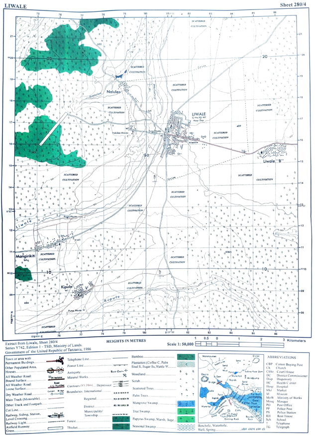
3. Carefully study the map extract of Kigoma sheet (92/3) and answer the questions that follow
(a) Calculate the length of Uvinza road in kilometers from grid reference 020635 to grid reference 950648
(b) Describe with evidence two methods used to show relief features from the map
(c) Citing evidence from the map, suggest three economic activities and two social activities that are taking place on the mapped area
(d) With evidence from the map describe any three functions of Kigoma town
(e) With evidence outline three types of settlement patterns from the map
(f) State three factors that might affect the content of a topographical map given.
4. The graph below showing production of 50,000 tons of maize recorded by farmer from 2015 to 2018 in Ruvuma region.

(a) Present the data above by using a simple bar graph
(b) Outline two (2) merits of using a simple bar graph.
5. Juma and Baraka conducted a dialogue about the shape of the Earth, Juma said that “The shape of the earth is flatted sphere” but Baraka argued that “The shape of the Earth is spherical” with six (6) point Justify the Juma’s argument.
6. Mr. Boniventure is a Geography teacher at Shy bush Secondary School. He taught his students theoretically on how to conduct a simple survey when they were in a classroom. On the next day he wanted them to do it practically where he told them to collect the materials that will be used to draw the map of their school compound. Mr. Boniventure wanted one among of his students to go and demonstrate the procedures that will be used in their surveying process.
(a) Suggest the type of land survey that will be used on their surveying process.
(b) Describe any four (4) instruments that will be used in the type of survey named in (a) above
(c) What are the merits of the type of survey used in (a) above? Give four (4) points
(d) Suggest two (2) main methods of booking in the notebook the details obtained while conducting the surveying process.
7. Study carefully the photograph below and then answer the questions that follow:-
|
|

(i) Identify the environmental problem occurred in the photograph above
(ii) Briefly explain three (03) possible causes of the phenomena above.
(iii) As a member of Geography subject club what would you do so as protect the environment against the phenomena mentioned in (i) above (three (03)points)
(iv) With two (02) evidences comment on the type of photograph.
8. Following “elephant crisis from 2009 to 2014, Dr, Paul was very interested and attempted to conduct a research to seek a solution to the existing problem. He consulted and selected some officers and other members of wildlife conservation from the Ministry of national resource and Tourism (MNRT) So as to collect relevant information.
(a) What is the type of research is this?
(b) Propose the best sampling technique used.
(c) Give the appropriate two (02) research topic tools might be applied.
(d) Name three (03) sources of research topic identified above.
SECTION C (30 MARKS)
Answer only two (2) questions from this section
9. After opening the school, Mwakipesile narrated a good story to his friends about the way he spent his holidays in Dar es Salaam. One of his friends is Darice who was happy to hear the story about coral reef found at the coast of Indian Ocean.
(i) Explain three (03) conditions which favor the formation of coral reef around Indian ocean,
(ii) With an aid of a well labelled diagram explain three (03) types of coral reef.
10. Forests have significant contribution to the social, economic and ecological development. NEMC Officers were passing in a village they saw people clearing the few trees that were remaining for various uses like charcoal, building and burning of bricks leaving the landscape of the village unpleasant. With six (06) points, explain how the challenge in the village will be addressed in order to rescue the situation.
11. “Life is only possible if the balance between the resource available and human population is mentioned by all of us”. Justify this statement by explaining any six (6) consequences of rapid population growth on environment.
FORM FOUR GEOGRAPHY EXAM SERIES 249
FORM FOUR GEOGRAPHY EXAM SERIES 249
THE UNITED REPUBLIC OF TANZANIA PRESIDENT'S OFFICE REGIONAL ADMINISTRATION AND LOCAL GOVERNMENT

MBEYA CITY COUNCIL ACADEMIC COMMITTEE
FORM FOUR PRE- MOCK
CODE:013 GEOGRAPHY
Time: 03:00 HRS April 2025
Instructions
- This paper consists of sections A, B and C with a total of eleven (11) questions.
- Answer all questions in this sections A and B and Two (2) questions from section C
- Section A carries sixteen (16) marks, section B fifty-four (54) marks and section C carries thirty (30) marks
- All writings must be in blue or black ink except drawing which must be in pencil.
- Map extract of Mkomazi (Sheet 109/1) is provided
- Programmable calculator’s, communication devices and any unauthorized materials are not allowed in the examination room
- Remember to write your examination number on every page of your answer booklet(s)
SECTION A: ( 16 Marks)
Answer all questions from this section
1. For each items (i)- (x) , choose the correct answer from the given alternatives and write its letter beside the item number in the answer booklet(s) provide.
i. What will happen when the orbit of heavenly body is nearest to the sun?
- Perihelion
- Aphelion
- Equinox
- Sunset
- Sunrise
ii. At the road construction site, John saw a layer of land with finest soil particles and more humus. Identify the layer observed by him.
- B – horizon
- A- horizon
- E – horizon
- C – horizon
- D- horizon
iii. It is noon in Adis Ababa ( 390E) . What will be the time in Dares Salaam which is located along the same Longitude ?
- 12:00 pm
- 12:00 am
- 06:00 pm
- 11:00 pm
- 06:00 am
iv. In order rain to be formed it has to pass through some stages, as an expert in geography student identify the correct processes of rain formation
- Cooling, evaporation, condensation and precipitation,
- Evaporation, cooling, condensation and rainfall
- Transpiration , cooling, Condensation and Rainfall
- Evaporation, precipitation, condensation and cooling,
- evaporation, rainfall, precipitation, condensation.
v. Saida was explaining to her grandmother about the layers the earth’s atmosphere. She told her that the atmosphere comprises of different layers in which one of them support rain formation due to its high amount of water vapour. From your understanding what is the name of the layer.
- Mesosphere
- Stratosphere
- Exosphere
- Troposphere
- Ozone layer
vi. Robert is living near the mountain within the time he noticed the bending of truck of trees and fences downward the slope . identify the process occurred
- Landslide
- Mudflow
- Soil creep
- Rock fall
- Soil erosion
vii. Suppose you are living in city center and you are interested in keeping livestock . What type of livestock keeping would be suitable for you?
- Nomadism
- Ranching
- Transhumance
- Pastoralism
- Sedentary
viii. At which stage of the river is deposition dominant
- The young stage
- The old stage
- The middle stage
- All stages
- upper course of the river
ix. The temperature of Mbinga at 1500m above the sea level is 230c. what will be the temperature of Newala which is at sea level?
- 0.80c
- 170c
- 0.60c
- 320c
- 100c
x. Suppose you were given several types of minerals and you were asked to select three non-metallic minerals. What would be your selection from the following alternatives?
- Coal, gold and copper
- Natural gas, silver and diamond
- Oil, diamond and coal
- Copper, silver and oil
- Gold, natural gas and diamond
2. Match the descriptions of karst region features in Column A with the corresponding feature in Column B by writing the letter of the corresponding answer beside the item number in the answer booklet provided.
| Column A | Column B |
| (i). The irregular gullies found on the limestone surface which separate limestone region. (ii). The vertical holes in the limestone ground through which rain water or river may disappear into the ground beneath. (iii) The round hollow on the surface of a limestone region. (iv) The wide depression with a fairly flat floor in a limestone surface. (v) The largest surface depression found in limestone region formed due to action of solution. (vi) Refer to a steep sided through lined by steep rock cliff formed as the results of collapse of the roof of the cave, |
|
SECTION A: ( 54 Marks)
Answer all questions from this section
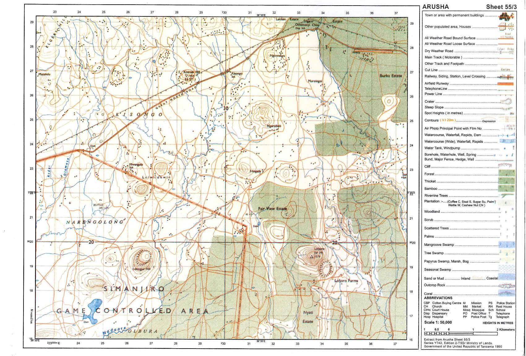
3. Study the map extract of Mkomazi (Sheet 109/1) and then answer the following questions:
- By using the given RF scale, measure the distance of river Pangani in kilometers from grid reference 910771 to 910826.
- Describe relief of the area.
- With reasons, identify two types of rocks found in the map.
- Name the major way used to show the height of the land in the mapped area.
- Using a vertical scale of lcm to represent 50m, draw an annotated cross section from grid reference 960820 to 910880 and mark Ruvu river basin and the main trucks.
4. The table below shows agricultural production in Tanzania from 2000 to 2006 in `000 tonnes.
| CROPS | 2000 | 2001 | 2002 | 2003 |
| Maize | 65 | 35 | 60 | 70 |
| Tobacco | 25 | 30 | 20 | 25 |
| coffee | 50 | 60 | 45 | 45 |
- Present the data by using a grouped bar graph.
- Comment on the nature of production.
5. There was land conflict between villagers of Lumbila and the Headmaster of Iyunga Secondary School. The village Chairperson decided to invite a survey team who used chain/tape survey to determine the boundaries of the school compound.
- Describe five instruments they used in surveying the school compound.
- Explain three procedures they followed during the survey process.
6. Madude is studying in boarding school at Kyela but his home place is in Mbalali District where he used to observe several conflicts between farmers and pastoralists. In his second week in school, he heard through the Radio that, a farmer was killed by the pastoralists in his home village. He decided to conduct research about the conflict.
(a) Suggest the statement of the problem for his research.
(b) Identify two sources of that research problem.
(c) Elaborate four possible research tools he would use during data collection.
(d) Explain three significance of conducting that research.
7. Study the photograph given below and then answer the questions that follow:

- With two evidence, name the type of the photograph.
- What is the name of the dominant vegetation shown on the foreground of the photographed area?
- With one (1) evidence from the photograph, suggest the climate of the photographed area.
- In three (3) points, show how vegetation depicted on the photograph adapt to the climatic conditions of the climate named in (c) above.
- Name the feature appearing on the background of the photograph and describe the geomorphic process responsible for its formation.
8. With the aid of the diagram describe six features produced by wave erosion
SECTION C (30 Marks)
Answer two (02) questions from this section
9. “Life is only possible if the balance between the resources available and human population is maintained by all of us. Justify this statement by explaining any six (6) consequences of rapid population growth on environment.
10. “Energy is the essential service whose availability and quality determines success or failure of development endeavors”. In light of this statement, explain six (6) challenges facing power and energy harnessing in Tanzania.
11. “Tanzania has been known to have a conducive and prospective geological environment with abundant potential of mineral deposits”. In six (6) points, examine the importance of mining sector to the economy of Tanzania.
 |
FORM FOUR GEOGRAPHY EXAM SERIES 246
FORM FOUR GEOGRAPHY EXAM SERIES 246
CHRISTIAN SOCIAL SERVICES COMMISSION (CSSC) NORTHERN ZONE JOINT EXAMINATIONS SYNDICATE (NZ-JES)
FORM FOUR PRE – NATIONAL EXAMINATIONS, 2024
013 GEOGRAPHY
Time: 3:00 Hours Monday 19th August, 2024 am.
Instructions
- This paper consists of section A, B and C with total of eleven (11) questions.
- Answer All questions in section A and B and two (2) questions from section C
- Section A caries sixteen (16) marks, section B carries fifty - four (54) marks and section C carries thirty (30) marks
- The map extract of MWANZA (sheet 33/2) is provided.
- Programmable Calculators, Cellular phones and unauthorized materials are not allowed in the examination room.
- Write your Examination Number on every page of your answer booklet(s).
SECTION A (16 Marks)
Answer all questions from this section
1. For each of the following items (i) – (x), choose the correct answer from the given alternatives and write its letter besides the item number in the answer booklet(s) provided.
(i) Taifa-stars scored first goal against Algeria at 7:10pm at Mkapa stadium in Dar es salaam ( 150 E). At what time the goal observed in Algeria ( 450 W) where some Tanzanians were watching the same game?
- 11:10 AM
- 10: 00 AM
- 03:10 PM
- 12: 30 AM
- 03:10 AM
(ii) Mr. Kombo is an educated Maasai who is keeping his cattle in one permanent place, he does not move from one place to another looking for pasture and water and instead he grows pastures in his farm for feeding his cattle. What is the general term of livestock keeping system Mr. Kombo is practicing?
- Nomadic pastoralism
- Semi – nomadic pastoralism
- Transhumance
- Sedentary livestock keeping
- Shifting cultivation
(iii) Three students of form one were debating on overhead sun date at the tropic of Capricorn, they didn’t reach on conclusion about it, until a form four student help them with a correct answer.
- 22nd December
- 21st march
- 21st June
- 23rd September
- 23rd June
(iv) Mwanahawa was making a geographical survey in different parts of Tanzania landforms; she was very much interested in a larger-lying area of land that was surrounded by high grounds.Choose the landform which Mwanahawa was interested in.
- Plain
- Valley
- Mountain
- Basin
- Hill.
(v) Geography subject teacher prepared a lesson about soil concepts on the vertical section showing the sequence of horizons. What does the concept mean?
- Soil texture
- Soil profile
- Soil horizon
- Soil structure
- Soil water
(vi) Pollution in the environment affects living things including human beings, pollution that causes loss of human hearing ability, mental illness even heart failure. What kind of pollution leads to such impacts?
- Water pollution
- Land pollution
- Air pollution
- Noise pollution
- Soil erosion
(vii) Geologist uses the chart for dating the history of the earth including its crustal rocks. As a form four student help your fellow form three students to identify such kind of the chart.
- Carbon 14
- Periodic table
- Geological time scale
- Measurement chart
- Ritcher scale
(viii) If temperature of Mpanda which is a 1500m above the sea level is 200C, what will be the temperature of Tumbatu Island which found at the mean sea level?
- 110 C
- 290𝐶
- 19.50 C
- 20.50 C
- 9.00 C
(ix) Mr. Katakona was wondering to see the mixture of gravel and soil saturated with water flowing down a slope under the influence of force of gravity. As a form four student what type of exogenic process was taking place?
- Snow avalanches
- Soil creep
- Talus creep
- Solifluction
- Earth flow
(x) The long river profile characterised by three different functions and each it’s intensity varies according to nature of the slope and river stages, hence lead to formation of different features respectively. Which of the following is not a feature produced in the old stage of the river?
- Delta
- Meanders
- Levees
- Rapids
- Ox-bow Lake
2. Match the concept in List “A” with the response in List “B” by writing the letter of the correct response beside the item number in the answer booklet (s) provided
| List A | List B |
| (i) Occur when cool air from over the water moves towards the warmer land during the day (ii) The wind that blows from subtropical high toward the equatorial low-pressure belts (iii) Occur when dense, cold air flow down a slope or mountain due to gravity (iv) The dry and warm air moving downward in the leeward side of the mountain (v) The wind whose direction reversed completely from one season to next seasons (vi) Dry and dusty winds which blows from the desert where the air pressure is high |
|
SECTION B
(54 Marks) Answer all questions in this section
3. Study carefully the map extract of Map extract of MWANZA (sheet 33/2) is provided and answer the questions provided below:
- Identify the type of rocks that might be found on the mapped area.
- Describe three (3) functions of Mwanza town.
- With precise evidence describe the climate of the area.
- Outline four (4) economic activities carried out in the area.
- Suggest two (2) environmental problems which might be facing the people at Mwanza.
- With evidence describe two (2) methods used to represent relief features of the mapped area
4. Mr Rogwa is an environmentalist from Jozani village in Zanzibar. He receives some claims from his fellow villagers on the rate of deforestation from making charcoal, he decided to conduct research for his society.
- Suggest type of research which might be used by Mr Rogwa and give the reasons.
- Elaborate basic two (2) methods to be considered by Mr Rogwa in collecting data.
- Explain three (3) objectives for this research.
- Identify two (2) problems that Mr. Rogwa may encounter in conducting this research.
5. One day Bahati was travelling to Dodoma, when he reaches at Gairo he saw a road engineer carrying a chain, arrows, note book, pencil, pegs and cross staff.
- Describe method of survey conducted by engineers.
- Explain three (3) kinds of obstacles that may hinder the survey process.
- Identify three (3) sources of mistakes that may occur during the survey process.
- Explain two (2) significances of the type of survey method which is done by the road engineers.
6. Study data below and answer the following questions about maize at Morogoro (000’tones) from 1980 to 1984.
| YEARS | 1980 | 1981 | 1982 | 1983 | 1984 |
| MAIZE PRODUCTION | 900 | 750 | 800 | 400 | 300 |
- Present the data above by drawing divergence bar graph.
- Describe any two (2) advantages of the method you have mentioned in (a) above.
- Briefly explain the steps or procedures taken to construct the divergence bar graph.
7. People living in areas close to mountain or hill slopes experience frequent down slope movements of rocks or soil. Recently it happened at Katesh in Manyara Region, Mbeya region and some parts of Tanzania.
- Describe the geographical phenomenon above.
- In four (4) points show the determinants of mentioned geographical phenomenon.
- In four (4) points Explain the environmental effect of the (a) above
8. Carefully study the following photograph and then answer the questions that follows:
|
|

- Name the environmental problem shown on the area.
- Mention an activity that accelerates this problem.
- Outline four (4) effects resulted from this environmental problem.
- Suggest three ways that can be used to reduce this problem in our environment
SECTION C (30 MARKS)
Answer two (2) questions from this section
9. Mr. Mkwabi wants to establish sugar manufacturing industry to eradicate scarcity of sugar supply which led to the increase of general price level of sugar in Tanzania. Analyze six (6) factors should be consider before locating of the industry.
10. Climate change has never been friendly to the environment.Verify this statement with six (6) points.
11. Form four students were given assignment of visiting rural areas of their ancestors to learn different matters relating to socio-economic and cultural values of society of their origin. Among the surprising fact they discovered was the presence of high birth rate in rural areas as compared to urban areas, where fertility rate is low. Present the findings by stating six (6) reasons for the situation in rural areas.
FORM FOUR GEOGRAPHY EXAM SERIES 283
FORM FOUR GEOGRAPHY EXAM SERIES 283
Student’s Examination Number . . . . . . . . . . . . . . . . . . . . . . . .
 | THE PRESIDENT’S OFFICE – RALG TAHOSSA ROMBO DISTRICT EXAMINATION SYNDICATE |  |
013 GEOGRAPHY
TIME: 3:00 Hours August, 2024
Instructions
- This paper consists of three section A, B and C with a total of eleven (11) questions.
- Answer all questions from section A and B and two questions from section C.
- Section A carries sixteen (16) marks, section B carries fifty four (54) marks and section C carries thirty (30) marks.
- Map extract of LIWALE sheet 280/4 is provided.
- All writing should be in blue ink except diagrams which must be in pencil.
- All communication devices and any unauthorized material are not allowed in the examination room.
- Write your Examination number at the top right corner of every page.
| FOR ASSESSORS’ USE ONLY | ||
| QUESTION NUMBER | SCORE | ASSESSORS' INITIALS |
| 1. | ||
| 2. | ||
| 3. | ||
| 4. | ||
| 5. | ||
| 6. | ||
| 7. | ||
| 8. | ||
| 9. | ||
| 10. | ||
| 11. | ||
| TOTAL | ||
| CHECKERS' INITIAL | ||
SECTION A: 16 MARKS
Answer all questions
1. For each of the items (i –x) choose the most from the given alternatives and write its letter beside the item number in the answer sheet (booklet) provided.
(i) All the following are famous tourist attraction sites in Tanzania except;
- Mikumi wildlife, Tarangire and Ruaha reserve.
- Serengeti national park, Mount Kilimanjaro and Mikumi
- Selous reserve, Tarangire and Mikumi Park
- Tsaro, Turkana and Oldonyo Lengai
- Tarangire, Ruaha reserve and Serengeti national park
(ii) SIMA and SIAL are separated by the zone called;
- Sialic
- Mohorovic discontinuity
- Mesosphere
- Conrad discontinuity
- Gutenberg discontinuity
(iii) Chemical weathering is most dominant in areas of;
- High temperature and high humidity
- Low temperature and low humidity
- High temperature and low humidity
- Low temperature and high Humidity
- Only high temperature
(iv) The prediction of the state of atmosphere in a region for 24 to 48 hours is known as;
- Weather elements
- Weather report
- Weather instruments
- Weather station
- Weather forecasting
(v) The temperature of Dodoma at 1200 meters above the sea level is 20?. What will be the temperature of Mbeya at 2000 meters above sea level?
- 16?
- 18?
- 15.2?
- 14.8?
- 30.4?
(vi) A channel diverging from the main river and flowing into the sea or lake by a separate mouth is known as;
- Watershed
- Distributary
- Tributary
- Ox – bow lake
- A stream
(vii) Suppose the local time at Greenwich meridian is 12:00 noon, what is the local time at Msepe which is 10°S 40°E?
- 12:20 AM
- 2:00PM
- 2:20 PM
- 2:40 PM
- 2:40 AM
(viii) Suppose you are living in urban center and you are interested in keeping livestock. What type of livestock keeping would be suitable for you?
- Nomadism
- Ranching
- Transhumance
- Pastoralism
- Sedentary
(ix) If the location of a point on a map is given by grid reference 365490, then;
- 490 are northings
- 490 are Eastings
- 365 are degrees
- 365 are northings
- 365 are longitudes
(x) Soil is among factors which determines economic activities together with;
- Climate
- Type of zone
- Nature of people
- Agricultural activities
- Equatorial zones
2. Match the descriptions of the forms of trade in column A with their corresponding names in column B by writing the letter of the correct response beside the item number in the answer book provided.
| LIST A | LIST B |
| (i) Measure relative humidity of the atmospheric pressure (ii) Used to determine direction towards wind which is blowing (iii) Used to measure atmospheric pressure (iv) Measure and record he duration of sunshine (v) Used to measure amount of rainfall (vi) Used to measure temperature of a place |
|
SECTION B (54 Marks)
Answer all questions in this section
3. Carefully Study the map extracts of Liwale sheet 280/4 provided, then answer the questions that follow
(a) With supporting evidence from the map, describe settlement pattern of the mapped area.
(b) By giving the evidence from the map, name four social activities carried out in the area
(c) Calculate the area covered by forest using square method. Give your answer in Km2.
(d) Change the scale of the map into a statement scale
(e) By giving evidence from the map, describe two main types of transport found in the mapped area.
4. Carefully study the following statistical data and then answer the questions that follow;
22, 13, 18, 4, 21, 16, 20, 16, 2, 16, 16, 15, 10, 16, 4, 8, 16, 18, 22, 8, 2, 8, 16, 6, 15, 20, 10, 23, 30 and 12
(a) Find
- Mode
- Mean
- Median
(b) What are the uses of statistical graphs and diagrams? Give four (4) points.
5. Following ‘elephant crisis’ from 2009 to 2014, Dr, Paul was very interested and attempted to conduct a research to seek a solution to the existing problem. He consulted and selected some officer and other members of wildlife conservation from the Ministry of National Resource and Tourism (MNRT) so as to collect relevant information.
- What is the type of research is this?
- Propose the best sampling technique used.
- Give the appropriate two research tools might be applied.
- Name three sources of research topic identified above.
6. (a) After learning different types of simple land survey students were asked to explain fruits of studying of chain survey but only Yoweri failed to explain. Assume you are a student who understood the
lesson, how will you help him to explain fruits of chain survey? (Any five points)
(b) Imagine you are geographical surveyor, describe the uses of the following instruments to form three students of certain secondary school.
- Pegs
- Arrows
- Cross staff
- Tape
7. Study carefully the following photograph and answer the questions that follow
 |
- With two reasons, name the type of photograph shown.
- What type of transport shown in the photograph?
- Name any two environmental pollutions caused by the photograph given at (a) above.
- Outline three challenges faced development of the transport shown in Tanzania.
- Mention three regions where the photograph might be taken
8. Juma and Baraka conduct a dialogue about the shape of the earth, Juma said that ‘the shape of the earth is flatted sphere’ but Baraka argue that ‘the shape of the earth is spherical’ with six (6) points, justify the Juma’s argument.
SECTION C (30 MARKS)
Answer two (2) questions from this section
9. Construction of Nyerere dam helps Tanzanians to earn advantageous than disadvantageous, as a student who studied regional focal studies in form two what you think Tanzanians will enjoy for that project.
10. Human activities enable the livelihood but in other hand they destroy the environment. Justify this statement by using six points that environmental problems resulted from human activities.
11. The Minister of national resources and Tourism in Tanzania has been so much active in promoting tourism sector. “Despite the economic significance of the sector, there are negative impacts to our country”. Elaborate this statement by giving six points.
 |
FORM FOUR GEOGRAPHY EXAM SERIES 225
FORM FOUR GEOGRAPHY EXAM SERIES 225
PRESIDENT�S OFFICE REGIONAL ADMINISTRATION AND LOCAL GOVERNMENT - RALG COASTAL REGION
REGIONAL FORM FOUR SECONDARY MOCK EXAMINATION
GEOGRAPHY
Code: 013
TIME: 3:00 HRS YEAR 2024�
INSTRUCTIONS
- This paper consists of three sections A, B and C with a total of eleven (11) questions.
- Answer all questions in section A and B and�any two (02) questions from section C.
- Section A carries sixteen (16) marks, section B fifty-four (54) marks and section C carries thirty (30) marks.
- All writings should be in blue or black ink except for drawing which must be in pencil.
- Map extract of�MWANZA (Sheet 33/2) is provided.
- Programmable calculators, communication devices and unauthorized materials are not allowed in the examination room.
- Write your Examination number on every page of your answer booklet (s).
SECTION A (10 Marks)
Answer all�questions in this section
1. For each of the items (i) to (x), choose the correct answer from the given alternatives and write its letter beside the item number in the answer booklet provided
i. The solar system is made-up of the sun, planet and other heavenly bodies which revolve around the sun, which planet has the shortest orbit?
- Pluto
- Mercury
- Mars
- Earth
- Venus
(ii) Suppose you want to carry out a field study on factors which used to classify the climate of a place, what are the best components of weather you are going to consider?
- Temperature and rainfall�
- Temperature and cloud cover
- Rainfall and sunshine�
- Cloud cover and humidity
- Sunshine and humidity
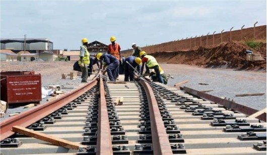
(iii) Tanzania is expecting to benefit a lot from the current Standard Gauge Railway (SGR) project. The following are some of the importance of this project except;
- A It will cause civil war
- B It will improve trade relations with neighboring countries.
- It will create employment opportunities
- It will encourage industrial development
- It will save time for transportation.
(iv) If you are living in urban center and you are interested in keeping livestock. What type of livestock keeping would be suitable for you?
- Nomadism�
- Ranching�
- Transhumance
- Pastoralism�
- Sedentary
(v) Form four students at Pengo village (75�W, 78� N) were watching the football on TV at 7.30 pm on Tuesday. At what time and day people in Keira village (45� E, 06� S) will be watching the same match?
- �3:30 am Wednesday�
- 12:30 pm Tuesday
- 11:30 am Wednesday�
- 3:30 pm Wednesday
- 09:30 am Tuesday
(vi) Tembo was explaining to his grandmother about the layer of the earths atmosphere, he told her that the atmosphere comprises different layers in which one of them support life to humans and other living organisms. Which layer carries those characteristics?
- Mesosphere�
- Atmosphere�
- Barry sphere
- Troposphere�
- Stratosphere
(vii) Janeth and her friends visited a nearly river and they saw a point where two streams met and form a single river. What did they see?
- Confluence�
- Distributaries�
- Tributaries
- Consequent streams�
- River mouth S.
(viii) People living in Bukoba � Tanzania experienced sudden vibrations of the Earths surface caused by movement of the molten rocks below or within the crust Identify the instrument used to measure the magnitude of such vibrations;
- Ritcher scale�
- Thermometer�
- Barometer
- Hygrometer�
- Wind vane
(ix) Hamisi at Chungwa secondary school had an interest in conducting geographic research on challenges that face street children in cities. What will be the last stage for his research?�
- Data collection�
- Data presentation�
- Report writing�
- Data analysis�
- Data processing
(x) Students were digging the toilet pits around the school, they observed different layers of soil usually of different texture and colors What does the soil refer lo?
- Soil profile�
- Soil texture�
- Soil stucture
- Soil porosity�
- Sand soil
2 Match the item in LIST A with the correct response in LIST B�by writing the letter of the correct response in the answer sheet provided
| LIST A | LIST B |
|
|
SECTION B (54 Marks)
Answer all�questions from this section
3. Study carefully the map extract of Mwanza (Sheet 33/2) and then answer the following questins
- By giving one evidence describe the type of map provided.
- Calculate the whole eastern area of the grid line 960 in km2
- How long is the road from grid reference 887220 to 967195 and turning back to original route? Give your answer in kilometer.�
- What is the main dominant type of settlement patterns in the mapped area?
- Explain two factors influencing people to live in the mapped area
4. Consider the data in the table below and answer questions that follow
| Year | 2014 | 2015 | 2016 | 2017 | 2018 |
| Number of students | 20 | 40 | 60 | 70 | 80 |
- Present the data above by drawing the divergence bar graph.
- Describe any two advantages and two disadvantages of the method you have used in (a) above.
5. Fatuma from Mkugilo Secondary School was asked by her teacher to conduct research on the reasons for poverty in Mwarusembe village where majority of the villagers did not know how lo read and write
- Suggest the best title for her research.
- Suggest any three (03) research tools used by Fatuma to collect data
- What arc the three (03) difficulties that Fatuma might face in the research process)
- What are the two (02) objectives of her study?
6. A group of people were walking in a series of connected chain while measuring linear distances and collected the side details near by the root way suddenly they met a bush which cannot see a way through, then they started complaining about the situation they faced as a result of not pre-visiting the area before any surveying work. Use the information above to answer the following questions;
- What is the name given to the group of people measuring linear distance?
- What is the step or procedure skipped before the survey work described?
- Mention one (01) merit of the skipped procedure.
- Explain three (03) major discrepancies in chain survey.
- Outline three (03) survey marking tools,
7. Mtanga Secondary School students visited the lower course of the river Rufiji and observed one of the features which is large, low-lying of alluvial deposits formed at gentle area at the mouth of the river before the river drains its water into the Indian Ocean.
- Identify the feature that was observed.
- Explain four conditions necessary for its formation.
8. Carefully study the photograph provided then answer the questions that follow;
|
|
- With two (02) evidences name the type of photograph provided.
- What is the activity carried out by the person shown on the photograph?
- Name three (03) regions in Tanzania where this type of crop is grown.
- State the climatic conditions that support the growth of the crop shown in the photograph.
SECTION C (30 Marks)
Answer two (02) questions from this section
9. Mzee Pwagu:�I want to locate an industry in our village.
Bi Chau: Industries are not built anywhere.
Mzee Pwagu:�Why?
What reasons Bi Chau should explain to Mzee Pwagu? Give six (6) reasons for Mzee Pwagus question as an answer.
10. Rahabu asks questions that "Why some areas are much more populated and other areas are much less and scattered in terms of population size and density." What reasons�will you give Rahabu?
11. "The world is facing several environmental problems" it is a delicate situation as we can see and hear in different kinds of mass media, Explain six�major environmental problems facing the todays World.
|
|
FORM FOUR GEOGRAPHY EXAM SERIES 215
FORM FOUR GEOGRAPHY EXAM SERIES 215
THE UNITED REPUBLIC OF TANZANIA�PRESIDENT�S OFFICE�REGIONAL ADMINISTRATION AND LOCAL GOVERNMENT

GAIRO DISTRICT COUNCIL
FORM FOUR PRE � MOCK EXAMINATION
013 GEOGRAPHY�
Instructions Time 3:00 Hrs - PM 20Th March 2024
- This paper consists of section A, B and C with total of eleven (11)�questions
- Answer all�questions in section A and B and any two (2)�questions from section
- Section A carries sixteen (16)�marks, section B carries fifty-four (54)�marks and section C carries thirty (30)�
- Map extract of LIWALE�(Sheet 280/4) is provided
SECTION A (16 marks)
Answer all�questions in this section
1. For each of the items (i)-(x), choose the correct answer from among the given alternatives and write its letter beside the item number in the answer sheet
(i) In order rain to be formed it has to pass through some stages as an expert in geography studies identify the correct processes of rain formation.
- Cooling, evaporation, condensation and precipitation
- Evaporation, cooling, precipitation and rainfall
- Evaporation, cooling, condensation and rainfall
- Evaporation, precipitation, condensation and cooling
- All the above.
(ii) Soil is among factors which determines economic activities together with:
- Climate
- Type of zone
- Nature of people
- Agricultural activities
- Equatorial zones
(iii) The tourist reported enjoying the temperature of Ihefu wetland in Mbeya at 1500 meters above sea level, which is 32C. They also planned to travel from Ihefu to Unguja in Zanzibar which is at sea level. What might be the temperature experienced by the tourist in Zanzibar?
- 23�C
- 0.6 �C
- 9 �C
- 41 �C
- 19 �C
(iv)The name given to a boundary that demarcates solid materials from the molten mantle is known as:
- Asthenosphere
- Gutenberg
- Mohorovic
- Mesosphere
- Core
(v) All the following are famous tourist attraction sites in Tanzania except?
- Mikumi wildlife, Tarangire and Ruaha
- Serengeti national park, Mount Kilimanjaro and Mikumi
- Selous reserve, Tarangire and Mikumi Park
- Tsaro, Turkana and Oldonyo Lengai
- Tarangire, Ruaha reserve and Serengeti national park
(vi) Dormant volcanic mountains are those which:
- Have never experience eruption
- Have erupted once but are no longer active
- Continue to erupt occasionally
- Erupt only when there is an earthquake
- Erupt every
(vii) The atmosphere is said to be humid only when:
- It is saturated with water vapour
- It is unsaturated with water vapour
- It contains water vapour
- It does not contain water
(viii) Suppose you are living in urban center and you are interested in keeping What type of livestock keeping would be suitable for you?
- Nomadism
- Ranching
- Transhumance�
- Pastoralism
- Sedentary
(ix) Robert is living near the mountain within the time he noticed the bending of truck of trees and fences downward the slope. Identify the type of process
- Land slide
- Mudflow
- Soil creep
- Rock fall
- Soil erosion
(x) Suppose you want to carry out a field study on factors which use to classify the climate of the place, what are best components of weather you are going to consider?
- Temperature and rainfall
- Temperature and cloud cover
- Rainfall and sun shine
- Cloud cover and humidity
- Sunshine and humidity
2. Match the items in list A with the correct response in list B by writing the letter of the corresponding response beside the items number in the answer sheet (s) provided
| LIST A | LIST B |
|
|
Section B (54 Marks)
Answer all�questions from this section
3. Carefully study the map extract of LIWALE�(sheet 280/4) and answer the questions that follow:
- Briefly describe two possible reasons for the growth of Liwale town
- Giving reason, identify the dominant type of rock in the mapped area
- Describe three characteristics of the rock mentioned in (a)
- Calculate the area covered by woodland at grid reference of 820130 and 870130
- Show the methods used to show Liwale town
4. (a) Classify three pollutants from manufacturing
(b) Explain five effects of these pollutants to the people and environment.
5. A group of researchers from Gairo District assigned a research work to find out critical reasons and solutions for truancy among
(a) You as a student, advice the researchers on best procedures to follow to have a successful
(b) Briefly explain any four uses of the findings obtained from research
6. After learning different types of simple land survey students were asked to explain fruits of studying of chain survey but only Yoweri failed to explain. Assume you are a student who understood the lesson, how will you help him to explain fruits of chain survey? (Any six points)
7. A sudden shake and vibration of the earth�s crust may have a number of outcomes
- What is his geographical phenomenon
- Outline four (4) outcomes of the phenomenon mention in (a) above
- What is the instrument would be used to measure the intensity of the hazard named in (a)
- Describe four (4) causes of the hazard in (a)
8. Carefully study the photograph provided below and then answer the questions that
|
|
- Name the crop shown in the photograph
- Mention three necessary physical conditions for the growth of the
- With two reasons determine the type of photograph
- Mention two contributions of economic activity taking
Section C (30 Marks)
Answer only two (02) questions from this section
9. Construction of Nyerere dam helps Tanzanians to earn advantageous than disadvantageous, as a student who studied regional focal studies in form two what you think Tanzanians will enjoy for that
10. Human activities enable the livelihood but in other hand they destroy the Justify this statement by using six points that environmental problems resulted from human activities.
11. The Minister of national resources and Tourism in Tanzania has been so much active in promoting tourism Despite the economic significance of the sector, there are negative impacts to our country. Elaborate this statement by giving six points.
|
|
FORM FOUR GEOGRAPHY EXAM SERIES 200
FORM FOUR GEOGRAPHY EXAM SERIES 200
PRESIDENTS OFFICE REGIONAL ADMINISTRATION AND LOCAL GOVERNMENT
LINDI REGION
FORM FOUR PRE-NATIONAL EXAMINATION
GEOGRAPHY
CODE 013
TIME 3:00HRS SEPTEMBER 2023
INSTRUCTIONS:
- This paper consist of sections A, B and C with a total of eleven (11) questions.
- Answer all questions in section A and B and two (2) questions from section C.
- Section A carries sixteen (16) marks, section B fifty four (54) marks and section C carries thirty (30) marks.
- Map extract of ARUSHA (sheet 55/3) is provided.
- Programmable calculators, cellular phones and any unauthorized materials are not allowed in the examination room.
- Write your Examination number on every page of your answer booklet(s)
SECTION A (16 MARKS)
Answer all question in this section
1. For each of the items (i-x) choose the correct answer from among the given alternatives and write its letter in the answer sheet provided.
i. The prediction of the state of the atmosphere can be done through both modern and traditional methods. Which among the following does not fit among the traditional methods used to predict weather.
- By looking at the position of the moon
- By hearing the voices of frogs
- By practicing female circumcision
- By hearing the voices of birds
- By experiencing the change of wind direction
ii. Form four students at Ngomanight secondary school were making the revision on the concept of land forms formed by vulcanicity. What do you think was the correct classification of volcanic landforms?
- Many parts according to Lava.
- Sills, dykes, valleys and earthquakes only
- Volcanic mountains and sills only
- Extrusive and intrusive features
- Batholiths, dykes and volcano only
iii. A scale of 4cm representing 18km on the ground will be represented by representative fraction (R.F) scale as:
- 1:900,000
- 1:1,800,000
- 1:450,000
- 2:900,000
- 1:10,000
iv. It was 5:00 p.m when Fiston Mayele the player of Young Africans, scored the goal against Mlandege FC at Benjamin William Mkapa stadium in Dar es salaam while it is 5:00p.m in Dar es salaam Tanzania in Burundi was 4:00p.m why do you think there was the difference in time between Tanzania and Burundi?
- Rotation of the Earth from East to West
- Revolution of the Earth
- Rotation of the Earth from West to East
- Rotation of the Earth from North to South
- Revolution and rotation of the Earth
v. Form two students at a certain school in Tanzania were taught that tourism can be done by observing minimum negative impact to the environment. Which type of tourism falls into this kind of practice?
- International tourism
- Domestic tourism
- Eco- tourism
- International tourism and domestic tourism
- Economic tourism
vi. During December holiday Caren and Kellyne decided to visit Azam company Limited in Dar es salaam where different products are made.They could see Mangoes being changes into juice and milk into Azam ice-cream. In what type of human activity does the Azam Company Limited activities falls?
- Primary human activities
- Tertiary human activities
- Quinary human activities
- Secondary human activities
- Quaternary human activities
vii. Rise and fall of development of any country is determined by number of factors. Suppose you have been invited by the regional commissioner of Lindi region to participate and contribute about the demographic change of the region. Which major three factors could you suggest?
- Mortality, fertility and climate
- Fertility, edaphic factor and mortality
- Fertility, migration and diseases
- Accidents, fertility and climate
- Mortality, birth rate and migration
viii. Mr Bigo is among the best livestock keeper in Kitelewasi village, he always ties sheep to a certain electric poles so that they get pasture. Identify the name of this system of animal keeping.
- Agriculture
- Sedentary farming
- Transhumance
- Tethering
- Nomadic pastoralism
ix. The people of Utengule Village are served by electricity from TANESCO and sometimes they use energy that they produce from Organic materials after being broken down by bacteria in an oxygen free environment. What is the name of such energy source?
- Hydroelectric power
- Biogas
- Solar energy
- Wind energy
- Solar energy
x. Mr. Richard had a chance to visit East African countries mostly Tanzania, Kenya and Uganda in 2018. He could experience the different climatic condition from that of his own country Iceland. Identify the type of climate he experienced in East Africa.
- Equatorial climate
- East Africa climate
- Savannah climate
- Tundra climate
- Mediterranean climate
2. Match the items in List A with response in List B by writing the letter of the correct response below the corresponding item number in the table provided.
| List A | List B |
|
|
SECTION B (54 MARKS)
Answer all questions from this sections
3. Study carefully the map extract of ARUSHA sheet 55/3 and the answer the following questions.
- Suppose the distance of the road reads 32cm on the map. By using the map scale given calculate the actual ground distance of the particular road.
- Citing evidence from the map, suggest two possible social services carried out in the mapped area.
- With the evidences from the map, identify two ways used to indicate features like mountain, rivers, hills, escarpment, saddles, ridges and other physical features in the mapped area.
- Give the name of the main man made linear physical feature found Northern part of the mapped area.
- Suggest the climate of the mapped area.
4. Study the data in the table below that shows the production of cash crops in Nyakanazi village in 000’tones from 2000 to 2003 and answer the questions that follow.
| YEARS | 2000 | 2001 | 2003 |
| CROPS | |||
| MAIZE | 200 | 260 | 275 |
| TEA | 100 | 200 | 180 |
| COFFEE | 150 | 220 | 200 |
QUESTIONS:
- Present the data by means of multiple bar graph.
- Give out two advantages and two disadvantages of the graph drawn in (a) above
5. Form four students were taught by geography teacher that “Research is a scientific and systematic way of collecting information about a certain phenomenon”.
- Show how research is systematic. Give ten points
- Outline four sources of geographic research problems
6. During the day, we see the sun floating in space. During the night we see the moon and other heavenly bodies floating in space too. But the sun is at the center of all other heavenly bodies.
- Outline the usefulness of the energy generated from the central body of the solar system. Give four usefulness.
- With the aid of diagram, show the occurrence of the phenomena when the moon is between the sun and the third heavenly body from the sun.
- Name the phenomena that take place when the moon is between the sun and the third heavenly body from the sun.
- Outline two characteristics of the sun.
7. The geography teacher at Kilimarondo Secondary school assigned his students to determine the relative heights of various points around their school. As an expert in surveying,
- Advice the students of Kilimarondo secondary school the suitable survey technique for their assignment
- Name at least four equipment you are likely to use.
- Briefly describe four significance of the surveying technique named in (a) above.
8. Carefully study the photography given and answer the questions that follow.
Questions:
- With (3) reasons name the type of photograph
- What is main activity taking place on the photograph?
- Suggest any three negative effects of this activity to the environment.
- Determine the weather condition at the time the photograph was taken.
SECTION C (30 MARKS)
Answer only two question from this section
9. Most of the villagers in Tanzania now days are highly developed in agriculture compared to the past due to the roles played by the government of Tanzania under the president “SAMIA SALUHU HASSAN”. What are the six factors which led to the expansion of agriculture in Tanzania?
10. Human activities have significant contributions to social and economic development but they are main causative for environmental problems in the world. As a form four student describe six problems facing our world today.
11. Juma visited kizwite village in 2004, he shifted to Zambia for business. After ten years he came back to Kizwite but he was surprised because Kizwite village was transformed to city. As a geographer explain six factors for such transformation.
 |
FORM FOUR GEOGRAPHY EXAM SERIES 187
FORM FOUR GEOGRAPHY EXAM SERIES 187
THE UNITED REPUBLIC OF TANZANIA�PRESIDENT�S OFFICE�REGIONAL ADMINISTRATION AND LOCAL GOVERNMENT
�ZONAL FORM FOUR MOCK EXAMINATIONS�
(NJOMBE, MBEYA, SONGWE, RUKWA AND KATAVI REGIONS)
013 GEOGRAPHY
INSTRUCTIONS
- This paper consists of section A, B and C with total of eleven (11) questions
- Answer all questions in section A and B and any two (2) questions from section C.
- Section A carries sixteen (16) marks, section B carries fifty�four (54) marks and section C carries thirty (30) marks.
- Map extract of KIGOMA (Sheet 92/3) is provided
- Cellular phones and any unauthorized materials are not allowed in the examination room.
- Write your Examination Number on every page of your answer booklet (s).
SECTION A: (16 marks)
Answer all�questions in this section.
1. For each of the following item (i)- (x), choose the correct answer from the given alternative and write its letter in the answer booklet
(i) Which among the following layers of the atmosphere is characterized by 16 kilometers -thick at the equator and its temperature decreases with an increase in altitude?
- Troposphere�
- Thermosphere�
- Stratosphere
- Mesosphere�
- Exosphere [ � � � ]
(ii) Suppose you are living in urban center and you are interested in keeping livestock. What type of livestock keeping would be suitable for you?
- Nomadism�
- Ranching�
- Transhumance
- Pastoralism�
- Sedentary [ � � � ]
(iii) Form four students at Kafule village (750 W, 780N) were watching the football on TV at 7:30 pm on Tuesday. At what time and day people in Itumba Village (450E, 060S) will be watching the same match?
- 3:30 am Wednesday�
- 12:30 pm Tuesday�
- 11:30 am Wednesday
- 3:30 pm Wednesday�
- 09:30 am Tuesday [ � � � ]
(iv) Jackline is not aware if the earth rotates on its own axis from west to east. Imagine you want to educate her, which factor among the following will you prove on your explanation?
- During the night stars are fixed at one position but are in motion
- Season of the year�
- Aphelion and perihelion
- The varying length of day and night
- When moving in a vehicle objects move in opposite direction [ � � � ]
(v) Robert is living near the mountain within the time he noticed the bending of truck of trees and fences downward the slope. Identify the type of process occurred
- Land slide�
- Mudflow�
- Soil creep
- Rock fall�
- Soil erosion [ � � � ]
(vi) Kadege and Anna were debating on the section of a river characterized by a sharp V-shaped valley and interlocking spurs. As you are familiar with those phenomena, select the correct answer to educate them.
- The old stage�
- The middle stage�
- The youth stage
- The mature stage�
- The young and middle stage [ � � � ]
(vii) Suppose you want to carry out a field study on factors which use to classify the climate of the place, what are best components of weather you are going to consider?
- Temperature and rainfall
- Temperature and cloud cover
- Rainfall and sun shine�
- Cloud cover and humidity
- Sun shine and humidity [ � � � ]
(viii) The national census which was conducted on August 2022 involved counting people who had stayed in the household during the night of enumeration. What kind of census was that?
- De jure�
- Quinquennial�
- Vital registration�
- De facto
- Decennial [ � � � ]
(ix) Form three students at Chonde Secondary school conducted a survey in Kondoa district and identified different types of soil erosion. Which one of the following is not a type of soil erosion?
- lateral erosion�
- Sheet erosion�
- Splash erosion
- Rill erosion�
- Gully erosion. [ � � � ]
(x) Mr Kakulum and his students visited a certain geographical area in Tanzania and saw the thick forest, tree dwellers, animals and people who were engaging in cultivating trees and coffee. What type of forest will you suggest among the following?
- Mangrove forest�
- Mediterranean forest�
- Tropical monsoon forest
- Equatorial rain forest�
- Coniferous forest [ � � � ]
2. Match the descriptions of the major features of the earth in Column A with its responses in Column B by writing the letter beside the item number.
| Column A | Column B |
|
|
SECTION B: (54 Marks)
Answer all�questions from this section.
3. Study the map extract of KIGOMA (sheet 92/03) provided and then answer following questions.
(a) Comment on the settlement patterns on the mapped area
(b) Show any two methods which have been used to determine the elevation of the mapped area
(c) By using grid method, find the area of Lake Tanganyika from grid 60 northward of mapped area
(d) Examine four land use of Kigoma area.
4. (a) Classify three pollutants from manufacturing industries.
(b) Explain three effects of these pollutants to the people and environment.
5. Mr Hanana is a farmer used to grow avocados at Mufindi village. He conducted research to know the best avocados seedlings which could make him yield high products from his farm. He divided his farm into small portions and planted different kind of avocados seedlings to see the results.
(a) Which method did Mr. Hanana used to collect data?
(b) What are the advantages of using that method you mentioned in (a) above? (Any three points)
(c) If you have a chance to advise Mr. Hanana the best methods he can use by the other time, which method would you advise him to use, Mention any two methods
6. After learning different types of simple land survey students were asked to explain fruits of studying of chain survey but only Yoweli failed to explain. Assume you are a student who understood the lesson, how will you help him to explain fruits of chain survey? (Any six points)
7. Katamba was inside the house where he observed a house shaking due to the vibration of the earth�s surface caused by natural forces operating beneath and on the earth�s crust. Answer the following questions to complete the descriptions
(a) What environmental hazard experienced by Katamba?
(b) What is the instrument would be used to measure the intensity of the hazard named in (a) above?
(c) Describe four causes of the hazard in (a) above.
(d) Explain four effects of the hazard named in (a) above.
8. Mr. Mpeligwa is the best geography teacher at Chimbe Secondary School. He teaches his students many types of photograph and one among the type of photograph is used in geographical research since can produce more accurate maps.
(a) With two reasons, suggest the type of photograph which can produce more accurate maps.
(b) Explain four similarities between the type of photograph mentioned in (a) above and map
(c) List three factors which may affect the quality of photograph
SECTION C: (30 Marks)
Answer two (02) questions from this section
9. In Tanzania natural gas deposits were discovered since 1975 at Songosongo Kilwa, but it has been delayed in realizing the full exploitation. Show how Tanzania will benefit from the exploitation of natural gas at Songosongo. (Give six points)
10. Human activities enable the livelihood but in other hand they destroy the environment. Justify this statement by using six�points that environmental problems resulted from human activities.
11. The Minister of national resources and Tourism in Tanzania has been so much active in promoting tourism sector. Despite the economic significance of the sector, there are negative impacts to our country. Elaborate this statement by giving (six points).
|
|

FORM FOUR GEOGRAPHY EXAM SERIES 166
FORM FOUR GEOGRAPHY EXAM SERIES 166
THE UNITED REPUBLIC OF TANZANIA PRESIDENT'S OFFICE REGIONAL ADMINISTRATION AND LOCAL GOVERNMENT
DODOMA REGION
FORM FOUR MOCK EXAMINATION- 2023
013 GEOGRAPHY
Time: 3 Hours August, 2023
Instructions
- This paper consists of eleven (11) questions in sections A, B and C
- Answer all the questions in sections A and B and two (2) questions from section C.
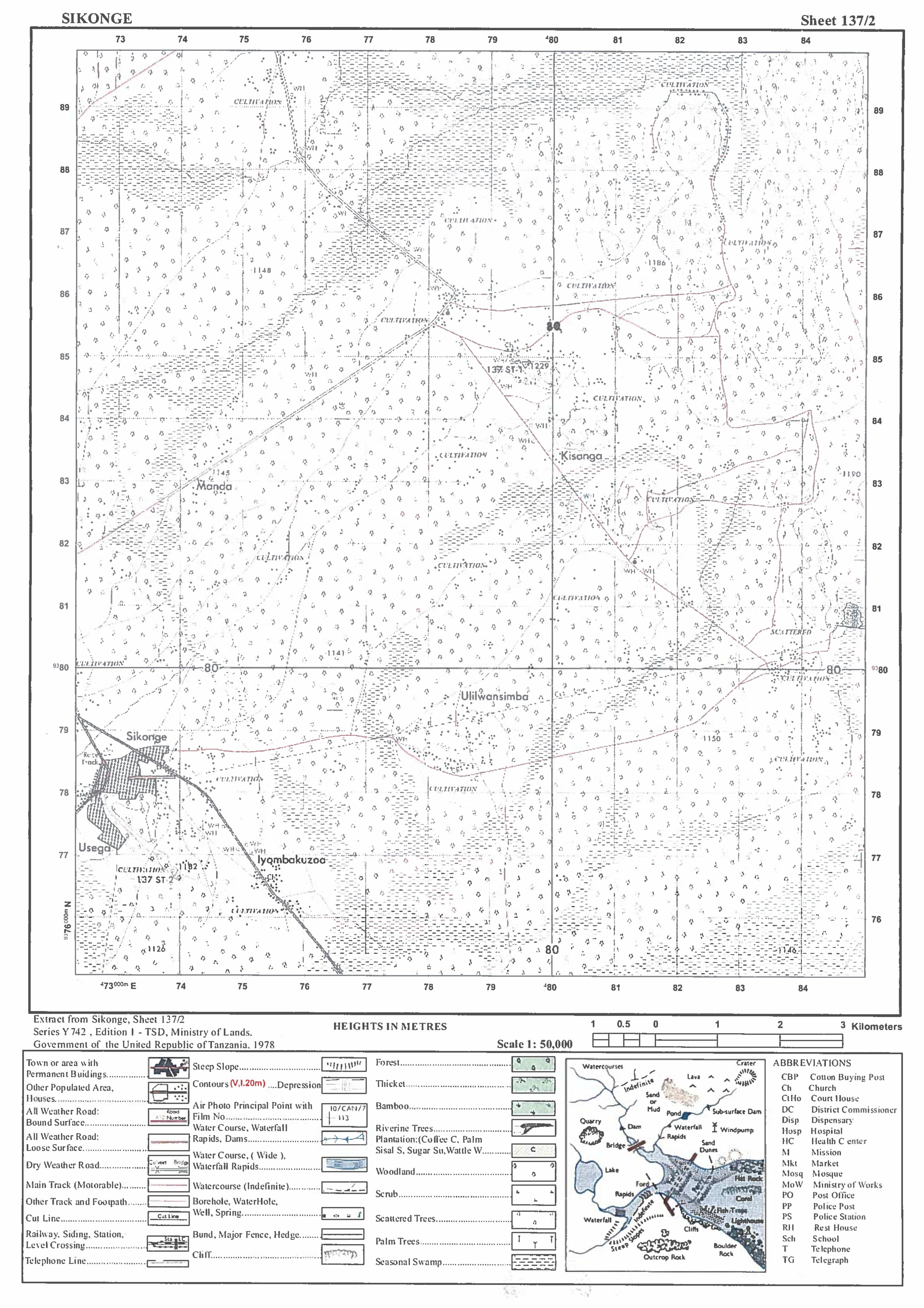
- Map extract of SIKONGE (Sheet 137/2) is provided.
- Unauthorized materials are not allowed in the examination room
- Remember to write your index number on every page of your answer sheet(s)
SECTION A (16 Marks)
Answer all questions in this section
1. For each of the items (i-x), choose the correct answer from among the given alternatives and write its letter besides the item number.
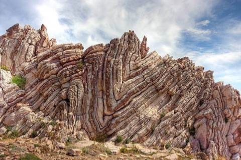
(i) Anna and John were arguing on the type of rock which constitutes the largest proportion of the earth’s crust. As a form four student what could you suggest?
- Metamorphic rocks
- Sedimentary rocks
- Carbonic sedimentary rocks
- Organically sedimentary rocks
- Igneous rocks
(ii) Msemakweli saw two streams/ small rivers that are Msilewe river and Mgongo river joining into Ruaha river, what is the geographical name of the two small rivers?
- Tributaries
- Perennial rivers
- Distributaries
- Nile river
- Watershed
(iii) Manchester United team scored a goal at 5:00 pm in England (150 W). At what at Dar es Salaam (450E) the goal was scored?
- 1:00 pm
- 7:00 pm
- 9:45 pm
- 9:00 pm
- 6:30 am
(iv) Recently in Chile, the land with vegetation was sliding down a slope and people were busy taking photographs and wondering to the situation. Tell them what type of geological process was taking place
- Erosion and deposition
- Denudation and transportation
- Land slide and erosion
- Mass wasting and transportation
- Landslide and deposition
(v) Which of the following layer of the earth’s interior is made up of sial and sima?
- Biosphere
- Hydrosphere
- Asthenosphere
- Lithosphere
- Barysphere
(vi) Siwema want to carry out a field study on the atmospheric conditions suitable for growth of maize on a farm village. What are the best weather components to be considered?
- Rainfall and wind
- Rainfall and cloud cover
- Moisture and sunshine
- Rainfall and temperature
- Pressure and humidity
(vii) During dry seasons most plants shade their leaves as a way to reduce the amount of water release. The correct term for this process is:
- Evaporation
- Precipitation
- Transpiration
- Condensation
- Infiltration
(viii) The rocks which do not allow water to pass through them are said to be:
- Water table
- Sand stones
- Porous
- Impermeable
- Rock Debris
(ix) Mr. Bukuku was wondering how fragments are worn out during collision against each other at Pangani river during rainy season. His son told him that the process is known as
- Hydraulic action
- Attrition
- Abrasion
- Corrosion
- Hydrolysis
(x) The Maasai around Oldonyo Le Ngai Mountain were wondering the way the mountain was ejecting fire and smoke. They believe that the mountain was possessed by bad evils. Tell them what geological process that was taking place
- Volcanic eruption
- Tectonic movements
- Mass wasting
- Fire from God
- Faulting
2. Match the question statement from List A and its answer from List B write its letter on your answer sheet.
| LIST A | LIST B |
|
|
SECTION B (54 Marks)
Answer ALL questions this section
3. Study the map extract of SIKONGE (sheet 137/2) and then answer the following questions:
a) Using the given RF scale, determine the length of the road in kilometers from grid reference 740829 to grid reference 760881.
b) Determine the area at the right hand side of the northing 800 in Km2
c) With examples, name two (2) ways used to show height of the land on the mapped area.
d) Under what climatic region the mapped area found?
4. Carefully study the table below showing food crops production in 2023 and then answer the questions that follow.
| Crop | Production in tonnes |
| Maize | 90,000 |
| Rice | 65,000 |
| Potatoes | 50,000 |
| Beans | 40,000 |
| Wheat | 20,000 |
| Sugar | 20,000 |
a) Draw a pie chart
b) Name two other methods which can be used to represent data
c) Give two disadvantages of the method above
5. Mr. Pompei was directed with TANAPA to investigate on the rapid increase on water weeds in some rivers inside the park. Before doing actual research, he decided to pass through various written documents.
a) Name the activity conducted by Mr. Pompei before actual research.
b) What was the importance of activity named in (i) above (four points)
c) What will Mr. Pompei prepare before his actual field research (four points)
6. Gamboshi district is planning to invite a survey team to help it determine the length of the Nyashimo to Ngasamo road.
a) What survey technique does the team was decided to use?
b) Draw three (3) equipment the team can use in the survey.
c) List five (5) objectives of land survey
7. Study the photograph provided below and then answer the question that follows:
a) Name the feature shown on the photo given
b) How does the feature in (a) above formed?
c) Mention any three (03) examples of feature mentioned in (a)
d) List three (03) economic importance of the feature
8. Draw and label eight (8) features of ocean floor.
SECTION C (30 Marks)
Answer two (02) questions from this section.
9. Explain six (6) challenges facing green tourism in Tanzania.
10. Mangare’s grandmother used to cultivate many crops in a small area using local seeds, a hand hoe and manure. She is now blaming that in five years the harvests are poor. She is complaining that her neighbours are the ones causing it. With six points, explain to her how she can improve her farming system.
11. Urban development is a new threat to our environment beauty. Discuss
|
FORM FOUR GEOGRAPHY EXAM SERIES 158
FORM FOUR GEOGRAPHY EXAM SERIES 158
THE UNITED REPUBLIC OF TANZANIA PRESIDENTS OFFICE REGIONAL ADMINISTRATION AND LOCAL GOVERNMENT

TABORA REGION
FORM FOUR REGIONAL MOCK EXAMINATION�
013�GEOGRAPHY
(For both School and Private Candidates)
Time: 3 Hours�Wednesday, May 10, 2023, p.m.
INSTRUCTIONS
- This paper consists of three sections A, B and C with a total of 10 questions.
- Answer all questions in sections A and B and two questions from section C.
- Section A carries fifteen (15) marks, section B carries fifty five (55) marks and section C carries thirty (30) marks.
- Map extracted of SIKONGE (SHEET 137/2) provided.
- Programmable calculators, cellular phones and any unauthorized materials are not allowed in the examination room.
- Write examination number on every page of your answer booklet(s). This paper consists of 6 printed pages.
SECTION A: (15 MARKS)
Answer all questions from this section
For each of the following items (i-x) choose the correct answer from among the given alternatives and write its letter in the space provided:
i. A meteorologist in the field study explained to the students that, during the day warmer air over the land surface rises vertically and is replaced by cooler from the sea. This process results to the movement of air called?
- Land breeze
- Sea breeze
- Night breeze
- Day breeze day and night breeze
ii. Mr. Mitomingi lived in Mwanza since 2015 and worked as a volunteering teacher at lgoma Secondary. In July 2022 he got employed by a government and transferred to a new school in Arusha region. Identify the type of Mr. Mitomingis movement.
- Migration
- Immigrant
- Immigration
- Emigration
- Emigrant
iii. People living around Lake Victoria are complaining for a lot of silt materials in Lake Victoria hence it has affected even ferrying activities at the lake. A certain expert advised them to take silt materials from the lake. What is the name of this process?
- Ferrying
- Transportation�
- Mudding
- Siltation
- Dredging
iv. A striker from African sports club won a prize for the best goal of the year in Tanzania, He scored the goal in Dar es Salaam (24�S, 39�E) at 4:10 pm. What will be the time in his home town Kinshasa (DRC) (34�N, 60 W)?
- 07:10 Am�
- 01:10 Pm�
- 06:22 Am
- 01:58 Pm�
- 08:20 Pm
v. Suppose you are living in an urban center and you are interested in keeping livestock. What type of keeping would be suitable for you?
- Sedentary
- Transhumance
- Ranching
- Pastoralism
- Nomadism
vi. It is believed that the NMB bank is the bank of all Tanzanians since it is available in most places in Tanzania. Under what category of activities the services provided by this bank are?.
- Secondary activities
- Tertiary activities�
- Primary activities
- Administration�
- Quaternary activities
vii. Ashura was living near the mountain in Arusha, As she lives she noticed the bending of trees and fancies downward a mountain slope, Identify the type of the phenomenon which causes the trees and fancies to bend.
- Land slide�
- Mud flow�
- Soil creep
- Soil erosion
- Rock fall
viii. Neema and his young brother Mussa like to play with wet soil around their home. They enjoy observing quick percolation of water in the soil. What type of soil were they playing with?
- Clay
- Silt
- Loam
- Sand�
- Silt and Clay
ix. The tourists reported enjoying the temperature of Ihefu wetlands in Mbeya at 1500 meters above the sea level, which is 32�C. They also planned to travel from Ihefu to Unguja in Zanzibar, which is at the sea level. What Might be the temperature experienced by the tourists in Zanzibar?
A. 23� C B. 0.6� C C. 9�C ( )
D. 41�C E. 19�C
x. Kelvin is a form three student; he conducted a simple research about rocks. In his research, he observed that some rocks expand when get heat and contract when get cold hence lose their outer particles. What is the geological process he observed?�
- Weathering
- Block disintegration
- Exfoliation
- Frost Action
- Pressure release
2. Match the following descriptions of agriculture in List A with the corresponding type of agriculture in�List B by writing its letter beside the table provided.
| List A | List B |
|
|
SECTION B (55 MARKS)
Answer all Questions
3. Study carefully the map extract of SIKONGE SHEET 137/2, and then answer the following questions.
- By giving evidence from the map. describe two methods used to show relief on the mapped area.
- By using the map extract�given, calculate the distance of all�weathered road loose surface from grid reference 740783 to grid reference 766750.
- Calculate the area covered by seasonal swamps from the mapped area.
- Apart from lumbering activity, use concrete evidences that may take place in the area.
- With vivid examples, comment on vegetation cover on the mapped area.
4.�Carefully study the following agricultural production data in Tanzania from 2011 to 2013 in "000" tones.
| Crops/year | 2011, | 2012 | 2013� |
| 1 Maize | 60 | 75 | 80 |
| 1,�Tobacco | 30 | 45 | 55 |
| 1 Coffee | 50 | 60 | 65 |
- �Present the data by using comparative bar graph.
- Comment on the nature of production.
- Suggest other two methods which could be used to present the provided data.�
- Give two advantages of the method used above.�
- Determine average of maize production.�
5. Suppose you are invited in a survey team and asked to use chain in taking linear measurement of the school playground. In the process, the team encountered with a hill along the traversing line.
- Identify the type of obstacle faced by the survey team during chaining process�
- Suggest two method that can be used to overcome such an obstacle�
- Show geographically how the team will overcome the Obstacle�
- Describe three (3) important persons involved in the team�
6. (a) A group of students were sitting at a high steep face of a rock along the sea coast of the Indian Ocean, They observed the breaking movements of ocean waves in which ocean water is thrown up the beach and returned under gravity down the shore
- What are the two wave processes the students observed?
- Mention four erosion processes involved in that ocean wave
- Identify three factors that affect wave erosion
- Draw a well labeled diagram to show the following features resulting from wave erosion
- Blow hole
- Cave
7. Study the following photograph carefully and then answer questions that follow;
 |
- With evidence, identify the type of photography
- List down three (3) characteristics of photography you mentioned in (a)
- With evidence suggest any three (3) economic activities that take place in the area.
- With vivid examples, name two (2) major types of transport.
- Propose any three (3) benefits of the middle ground part of the photographed area.
SECTION C: (30 MARKS)
Answer TWO (2) questions from this section
8. In 2021, form four students from Kariakoo secondary school conducted the field research about the effect of global worming. Finally, they submitted the report to the head of school.
- Suggest a suitable title of the research.
- Suggest any three sources of data for the research.
- Describe chronologically the first four (4) stages that students will pass through to conduct the research.
9. Johns grandfather believes that studying of geography in the current globalized world is wastage of time since each and everything can be accessed through social networks, television or Internets. By using six (6) points prove wrong Johns grandfather.
10. Mrs. Alex is a university student at UDOM, she conducted her research about the population by using different research tools including observation and she found that some of areas in Tanzania are highly populated while some are not populated at all over the Earths surface. Support Mrs. Alex with six (6) reasons why such situation exists in Tanzania.
|
FORM FOUR GEOGRAPHY EXAM SERIES 150
FORM FOUR GEOGRAPHY EXAM SERIES 150
THE PRESIDENT’S OFFICE, REGIONAL ADMINISTRATION AND LOCAL GOVERNMENT
LINDI REGION
FORM FOUR MOCK EXAMINATION
013 GEOGRAPHY
TIME: 3:00 HOURS May, 2023
Instructions
- This paper consists of sections A,B, and C with total of Eleven (11) questions.
- Answer all questions in Section A and Band any two(02) questions from section C
- Section A carries sixteen (16) marks, Section B carries fifty-four (54) marks and Section C carries thirty(30) marks
- Map extract of KIGOMA (series 92/3) is provided.
- Programmable Calculator and Cellular phones are not allowed in Examination room.
- Write your Examination number one very page of your answer sheet.
SECTION A (16Marks)
Answer all questions in this section
1. For each of the items (i)–(x) choose the correct answer from among the given alternatives and write its letter besides the item number in the answer booklet provided below.
i. Raajii wants to carry out a field study on the atmospheric condition suitable for growing maize on his farm land. What is the best weather elements he should consider?
- Rainfall and Wind
- Rainfall and clouds cover
- Moisture and sun shine
- Rainfall and Temperature
- Pressure and humidity
ii. The greenhouse gases can depletethe Ozone layer among other effects of Ozone layer depletion can also cause.
- Good visibility
- Clouds formation
- Skin cancer
- Environmental separate
- Glaciations
iii. The maximum and minimum bulb thermometers are likely to give the same readings, when the air
- Is saturated
- Is not saturated
- Is wet
- Is dry
- Is very hot
iv. Form one students enjoyed the temperature of Mbagala which was 32?C at sea level. They also planned to travel from Mbagala to Kilolo which is 1500M above the sea level. What will be the temperature experienced by the form one students in Kilolo?
- 23°c
- 9°c
- 17o c
- 0.6°c
- 19°c
v. You are asked to select the type of soil that is both, permeable and impermeable depending on the extent of saturation. What will be your selection among the following?
- Loamy
- Silty
- Sandy
- Sedimentary
- Clay
vi. Dowasa manager wants to construct a well that will serve water supply permanently to thesociety of Dodoma city. Which layer would your advice to be reached by the pipes to tape the underground water?
- The intermitted zone
- The aquifer
- The zone of non-saturation
- The aquicludes E.The water table.
vii. Mr. Job grows flowers, vegetable and other plants that cause aesthetic environment, what kind of agriculture is that?
- Aquaculture
- Horticulture
- Garden
- Portculture
- Botanism
viii. What would be the name of the sand bar that might join the Dar-es-salaam and the Zanzibar shores,being constructed by wave action?
- Mudflat
- Spit
- Beach
- Tombolo
- Cuspate foreland
ix. Your Geography teacher has planned to take you as his Geography students to visit European countries during summer season, which month would you advise him to go?
- January
- September
- December
- March
- June
x. A feature you do not see in Tanga Tanzania in the Amboni cavern.
- Stalagmites
- Stalactites
- Levees
- Natural pillars
- Underground rivers
2. Match the description of desert land forms in list A with the corresponding names in list B by writing the letter of the correct response beside the item number in the answer booklet(s)
| LISTA | LISTB |
|
|
SECTION B (54 MARKS)
Answer all questions in this section
3. Carefully study the map extract of Kigoma (sheet 92/3) provided, then answer the following questions:
- Calculate the total distance covered in kilometers if the train is travelling from grid reference 940633 to the center in grid reference 000583 and returned back. (Provide your answer in km)
- With evidence from the map, describe the nature of relief in the mapped area.
- Calculate the area covered by the Lake Tanganyika using the square method. Give your answer in km2
- By giving evidence from the map, name four social economic activities carried out in the area.
- The table below show agricultural production in Tanzania from 2011 to 2013 in “000” Tones.
| CROPS/YEAR | 2011 | 2012 | 2013 |
| Maize | 60 | 75 | 80 |
| Tobacco | 30 | 45 | 55 |
| Coffee | 50 | 60 | 65 |
- Present the data by using comparative bar graphs
- Suggest other two methods which could be used to present the provided data
- Give two advantages of the method used above
5. There was a serious conflict between farmers whose plots was nearby each other. They tried to resettle the conflict but they failed and later on they decided to consult the Village Executive Officer to seek the resolution. The Village Executive Officer decided to send the village land resolution team to the field. The team decided to use the method of linear measurement.
- Identify the method of taking measurement used
- List down any four instruments that were used
- If the team consisted of three personnel’s in taking linear measurement. Who are those?
- Describe any three (3) significances of using the method identified in (a) above
6. Junior was inside the house where he observed sudden shaking of the floor due to the vibration of the earth’s surface caused by natural tones operating beneath the Earth’s crust. Answer the following questions.
- Name the environmental hazard experienced by Junior?
- What is the instrumental used to measure the intensity of the hazard named in (a) above?
- Briefly explain the four causes of the hazard in (a) above.
- Describe three (3) effects of the Hazard named in (a) above
7. Carefully study the photograph below then answer the questions that follow
- Name the type of photograph
- Identify what is seen at the fore ground of the photograph.
- With evidence from the photograph suggest the economic activity that might be taking place in the area.
- Mention any three advantages and three disadvantages of the activity mentioned in (c) above.
8. The Ilulu girl’s secondary school located at Kilwa – Lindi prepared the questions in advance in which the same questions were asked to all students who attended the school with a need of securing a chance in the academic year 2023 for form one class.
- Identify the type of interview used by Ilulu secondary school.
- Give out four (4) procedures of conducting interview
- Outline two (2) merits and two (2) demerits of the interview method
SECTION C (30 MARKS)
Answer two (02) questions from this section
9. “Despite of the fact that road transport causes a lot of accidents in Tanzania, most Tanzanians prefer road transport to Air transport”. With six points justify this statement.
10. Large population has advantages of having good number of labor force, discuss six Challenges associated with rapid population increase in the world.
11. A Geography teacher at Kutishana Secondary school taught his students that “Soil has physical, chemical and biological properties”. With facts and vivid example, you as an expert in Geography clarify six (6) properties of soil which were taught by Geography teacher at Kutishana Secondary School to his students.
|
|
FORM FOUR GEOGRAPHY EXAM SERIES 140
FORM FOUR GEOGRAPHY EXAM SERIES 140
PRESIDENT’S OFFICE REGIONAL ADMINISTRATION AND LOCAL GOVERNMENT
MVOMERO DISTRICT COUNCIL
FORM FOUR MOCK EXAMINATION
013 GEOGRAPHY
Time : 3 Hours MAY 2023
Instructions
- This paper consists of section A,B and C with total of eleven (11) questions.
- Answer all questions in section A and Band TWO (2) questions from section C.
- Section A carries a total weight of 16 marks, section B carries 54 marks and section C carries 30 marks.
- All writings should be in a blue or black pen except for diagrams that must be drawn in pencil
- Write your full name on every page of your answer booklet
- An extract map of MKOMAZI sheet 109/1 is provided
SECTION A: (16marks)
Answer all questions in this section.
- For each of the items (i)-(x) choose the correct answer from among the given alternatives and write its letter beside the item number.
- Which one among the following by origin and composition is not a form of igneous rocks?
- Sill
- Gypsum
- Lavaplain
- Volcano
- Granite
- Sometimes the shape of the sea is anomalous, it can enter the land or surrounded by land sometimes surround the land. All these appearances have different name. What is the name of the part of sea that is surrounded by land?
- Peninsula
- Cape
- Island
- Gulf
- Strait
- Joyce wondered to see the objects with leading heads and bright tail in the sky which were made up of ball ice, dusts and gases. According to your understanding what do you think were those objects?
- Asteroids
- Meteors
- Satellites
- Comets
- Meteorites
- Problem in the Indian Ocean where the captain called for the help from the Engineer crew. He told them, the ship is found somewhere in the East. What is the bearing of that direction?
- 112.50
- 247.50
- 2250
- 67.50
- 157.50
- Dr. Limo addressed the meeting at Mombasa (150E) at noon. The people of Benin observed the same speech at 8:00 am on the Television. Suggest the Longitude of Benin
- 300 W
- 450 W
- 450 E
- 600 E
- 600 W
- Suppose you have been invited by your fellow students at Diongoya Secondary school to educate them about the topic of major features of the earth’s surface which are formed by the process of wrinkling of the Upper parts of the earth crust due to compressional force. Which one among the following features will you present to them
- Block Mountains
- Fold Mountains
- Volcanic Mountains
- Rift Valleys
- Residual Mountains
- Mwajuma was explaining to her grandmother about the layers of the earth’s atmosphere. She told her that the atmosphere comprises of different layers in which one of them support rain formation due to its high amount of water vapour. From your understanding, what is the name of that layer?
- Mesosphere
- Stratosphere
- Exosphere
- Troposphere
- Ozone Layer
- Dotto cultivates a piece of land and she leaves it for some years regain its fertility. She is now expecting to go back for cultivation next year. What is the type of cultivation Dotto practicing?
- Mixed farming
- Shifting cultivation
- Modern cultivation
- Mono-cultivation
- Bush fallowing
- It is a fact that Ocean currents are set in motion. Which one among the following is the reason for the movement of the Ocean currents?
- Revolution of the Earth
- Rotation of the earth
- Gravitational force
- Lunar Eclipse
- Overhead sun
- The people of Ndole village are not served with Electricity; instead they are using the energy that is produced from Flora and Fauna products after being broken down by bacteria in an oxygen tree environment. From the knowledge you have acquired in from two on the topic of sustainable use of power and energy resources. What is the name of such energy?
- Wind Energy
- Solar Energy
- Hydro Electric Power
- Geothermal Energy
- Biogas Energy
- Match the descriptions of Settlement in LIST A with the correct answer in LIST B by writing the letter of the correct response beside the item number in the answer book sheet(s) provided.
| LIST A | LIST B |
|
|
SECTION C: (54 Marks)
Answer ALL questions in this section.
- Carefully study the map extract of MKOMAZI (Sheet 109/1) provided then answers the questions that follow.
- Mr. Bakari decided to travel by a motorcycle using a road from grid reference 901904 to grid reference 030803 and then go back to the point where he started. Determine the actual distance covered by Mr. Bakari in Km.
- Calculate the area covered by seasonal Swamps on the mapped area. Give your answer in Km2.
- With evidence from the mapped area suggest any three (3) economic activities which are conducted by this area.
- State three factors that might affect the content of a topographical map given.
- Alex Morison, a form four student at Mtakuja secondary school was presenting on the class the construction of divided bar graph; during her presentation he mixed the procedures of presenting the data. As a form four students assist him by;
- Outline steps for constructing the graph.
- Point out three merits and three demerits of the method.
- Present the statistical data of cash crop production (000tones) in Tanzania in the year 2005 to 2008 by using divided bar graph.
| Year/Crop | 2005 | 2006 | 2007 | 2008 |
| Coffee | 200 | 400 | 500 | 400 |
| Sisal | 350 | 550 | 700 | 600 |
| Rubber | 400 | 650 | 800 | 450 |
- Mr. Boniventure is a Geography teacher at Shy bush Secondary School. He taught his students theoretically on how to conduct a simple survey when they were in a classroom.On the next day he wanted them to do it practically where he told them to collect the materials that will be used to draw the map of their school compound. Mr.Boniventure wanted one among of his students to go and demonstrate the procedures that will be used in their surveying process.
- Suggest the type of land survey that will be used on their surveying process.
- Describe any four(4) instruments that will be used in the type of survey named in (a) above
- What are the merits of the type of survey used in (a)above?Give four(4)points
- Suggest two (2) main methods of booking in the notebook the details obtained while conducting the surveying process.
- Suppose you want to conduct a research about maize production in your district from 2015 to 2020 and your interest is to know whether the production was increasing or decreasing.Your plans is to consult the farmers who were directly involved in the Maize production for the said period and the District Agricultural Extension officer for more information.
- What will be the best research approach for your study?Givereason.
- Describe the main source of data for your study
- Identify two individuals who will be the respondents for your study.
- Formulate the null hypothesis and Alternative hypothesis for your study.
- As a good researcher, why do you think it is very important to pass,through various,publications like journals,books,research reports done by other people,Newspaper,before you conduct your study?Give four(4) points.

- Carefully study the photograph below and then answer the questions that follow.
- Suggest the type of the photograph above. Give two reasons
- Write short description of what you see in the photograph.
- Identify the white space seen in the photograph at the back ground of the photograph.
- Give two (2) disadvantages which might be brought by the animal seen on the photograph.
- With evidences from the photograph identify three (3) economic activities that might be conducted in this area.
- With evidence from the photograph suggest possible climate of area on this photograph.
- Mr. Kasheko was watching the video program showing the ejection of molten materials with in the earth`s crust or onto the earth `s exterior. This process accompanied with the outbreak of ashes,gases and smokes. This molten materials sometimes cool solidify within the earth’s crust to form both hypabyssal and plutonic rocks. And sometimes other materials reach the surface to form volcanoes.
- What is the genetic process observed by Mr. Kashekofrom the video program?
- With examples explain the types of features produced by the process named in (a) above?
- Outline five (5) environmental impact resulted from the process in (a) above.
SECTION C: (30Marks)
Answer only Two (02) questions from this section.
- Kawaida’s grandmother believe that studying of Geography in the current globalized world is just a wastage of time since each and everything can be accessed through social networks, Televisions, andInternets. As a geographer student, assist Kawaida’s grandmother by proofing that studying geography is significant in our daily life. Give six (6) points.
- Mr. Benedict he great believe that human activities can lead to the modification of the physical environment and distribution of people. On the other hand this may be as the result of the types of environment in the area. With six (6) points, explain the factors influences population distribution in Tanzania.
- Despite of the fact that road transport causes a lot of accidents in Tanzania, most of Tanzanians prefer road transport to Air transport. With (6) points justify this statement.
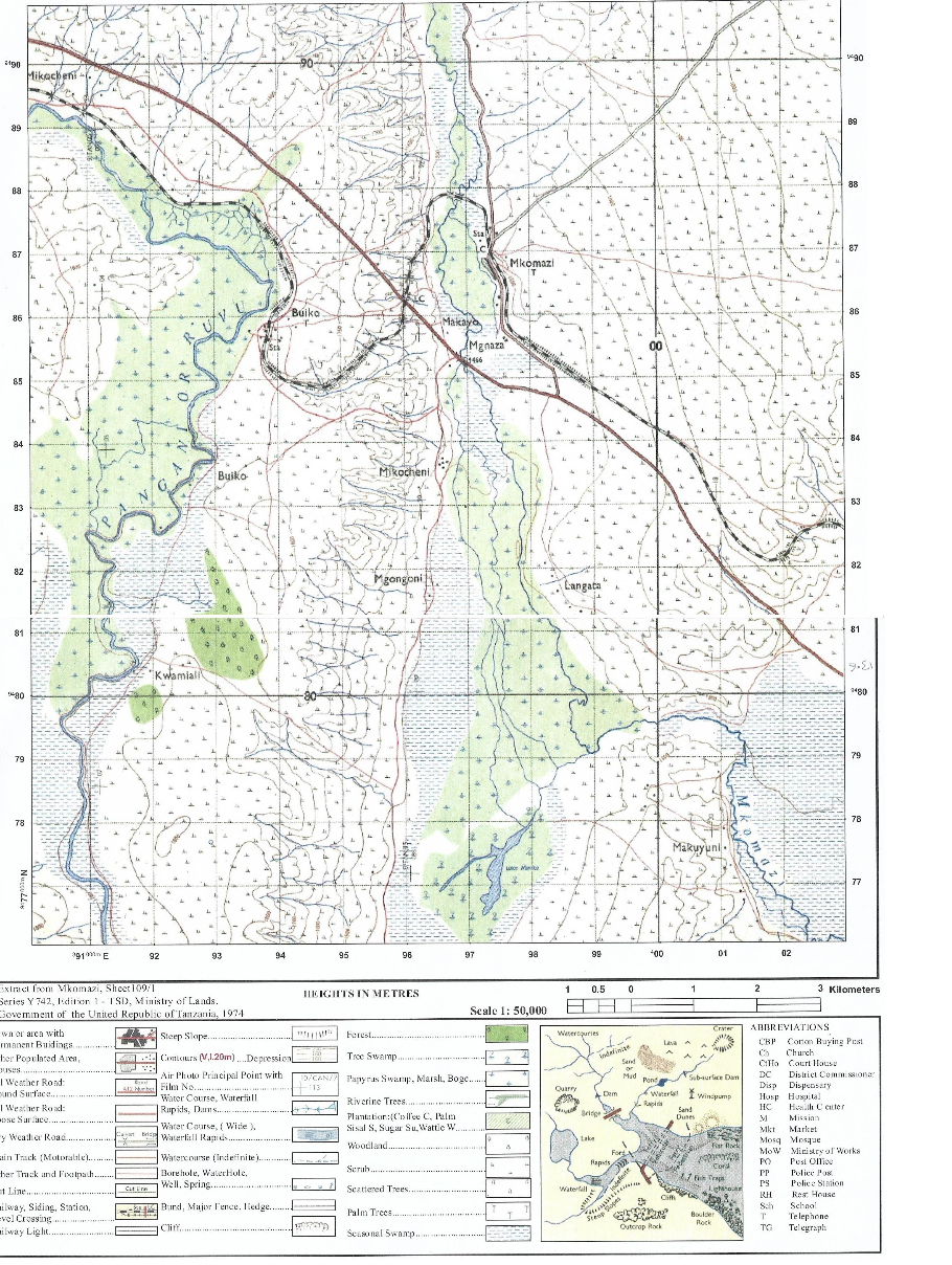 |
FORM FOUR GEOGRAPHY EXAM SERIES 130
FORM FOUR GEOGRAPHY EXAM SERIES 130
PRESIDENT'S OFFICE REGIONAL ADMINISTRATION AND LOCAL GOVERNMENT
KILIMANJARO REGION MOCK FORM FOUR EXAMINATION
CODE: 013 GEOGRAPHY
TIME: 3 HOURS MAY 2023
INSTRUCTIONS
- This paper consist of sections A, B and C with a total of 11 questions.
- Answer all questions from section A and B and only TWO questions from section C.
- The map extract of MBEYA (sheet 244/4) is provided
- Programmable calculators, cellular phones and unauthorized materials are not allowed in the examination room
- Write your candidate number on every page of your answer booklet(s)
- Put a TICK for the attempted questions
| QN | NUMBER SCORE | EXAMINER'S INITIALS |
| 1. | ||
| 2. | ||
| 3. | ||
| 4. | ||
| 5. | ||
| 6. | ||
| 7. | ||
| 8. | ||
| 9 | ||
| 10 | ||
| 11 | ||
| TOTAL |
|
|
SECTION A (16 Marks)
Answer all questions in this section
1. For each of the items (i - x), choose the correct answer from among the given alternatives and write its letter besides the item number in the answer booklet provided
(i) Mr Kayange decided to construct a' map with each 2cm representing 8.4 km on the ground. What is the representative fraction scale did he put in this map?
- 1: 840000
- 2:8:4
- 1:100000
- 1:420000
- lcm: 84km
(ii) One teacher was assigned by the head of school to counsel his students because of peer influence. Suggest the level of human activities conducted by the teacher.
- Tertiary activities
- Quinary activities
- Secondary activities
- Quatenary activities
- Guidance and counseling
(iii) The students of the University of Dar es salaam were presenting their research findings about COVID-19 in BEN- DRC (30°E) at 10:30am. Their fellow students Were-watching television in Dar es salaam Tanzania (45°E). what is the local time at Dar es salaam?
- 11:30pm
- 9:30 pm
- 9:30 am
- 11:30 am
- 11:45 am
(iv) Asha is a famer from Nguvumali village, she went to the agricultural officer to ask on the type of soil with clear distinguishable horizons which occurs in definite regions of climate and vegetation. What type of the soil did the agricultural officer mention to Asha?
- Intrazonal soil
- Zonal soil
- Ozonal soil
- Clay soil
- Desert soil
(v) BWANA KOROSHO is a peasant at CHAUME village in TANDAHIMBA district who applies proper methods of farming. Identify some proper methods of farming BWANA KOROSHO uses •
- Terracing, overgrazing and contour ploughing
- Recycling, bush fallowing and terracing
- Contour ploughing, crop rotation and mulching
- Terracing, overgrazing and crop rotation
- Shifting cultivation, terracing and overstocking
(vi) You are provided with several examples of industries, which one among the following is an example of fabrication industry?
- Chemical industry
- Metallurgical industries
- Textile industries
- Ship building industries
- Iron smelting industries
(vii) Mr. Mweneyuni wanted to dig a dam for the purpose of obtaining water for his garden during dry season, but he did wrong by digging on the area with the rock which allows further percolation of water. As a skilled geography student, identify the type of rock on which Mr. Mweneyuni dug his dam.
- Permeable rock
- Igneous rock
- Impermeable rock
- Rock cycle
- Parent rock
(viii) A girl was crossing a river and accidentally dropped her school bag in the river. The girl cried as she observed her bag being pulled by the river water towards the river mouth. What could the bag named in relation to the river action?
- River erosion
- River bed
- River transportation
- River meander
- River load
(ix) From 2015 Tanzania is struggling to transform her economy from agricultural based to industrial based economy, but one of the effects of the industrial based economy is pollution. Identify four types.of pollution caused by industries.
- Soil, water, noise and air pollution
- Nuclear, land, noise and air pollution
- Radiation, water, air and noise pollution
- Air, noise, water, and nuclear pollution
- Land, radiation, noise and nuclear pollution
(x) Students visited mount Q, while walking they saw the land which has been displaced in different levels. Their geography teacher told them the name of that feature. What do you think is the feature?
- Shear fault
- parallel steps
- Reverse fault
- Normal fault
- Fault steps
2. Match the items in list A with the correct responses from list B by writing the letter of the most correct responses beside the item number in your answer booklet
| LIST A | LIST B |
|
|
SECTION B (54 MARKS)
Answer all questions in this section
3. Carefully study the map extract of MBEYA (sheet 244/4) and answer the following questions
- Calculate the length of the Rail line from grid reference 440130 to 540128 in kilometers
- Describe the relief of the mapped area.
- With evidence from the map, identify the climate of the area
- Giving evidence from the map suggest two economic activities carried out on the mapped area.
4. Study carefully the table below on hypothetical data about cars importation in (000) in Tanzania in the year 1998- 2001, then answer the questions that follow.
| TYPE OF CAR | YEARS | |||
|
| 1998 | 1999 | 2000 | 2001 |
| BMW | 400 | 700 | 500 | 600 |
| IST | 350 | 600 | 700 | 200 |
| SPACIO | 500 | 800 | 700 | 300 |
- present the data of SPACIO car importation in divergent line graph
- Give out the procedures on how to construct divergent line graph
- comment on the variation of SPACIO car importation to Tanzania (give out three reasons)
5. Suppose you want to conduct a research about maize production in your district from 2008 to 2018 and your interest is to know whether the production has increased or decreased. Your plan is to consult farmers who were directly involved in maize production in the said period and visit the district agriculture officer for.more information
- What will be the best research approach to your study?
- Name the main source of data for your study
- Identify two individuals who will be the respondents for your study
- Mention your possible sources of research problem for the study
6. There was a serious conflict between farmers whose plot were nearby each other. They tried to settle the conflict but they failed and later on they decided to consult the village executive to seek for the resolution. The village executive officer decided to send the village land resolution team to the field. The team used the method of linear measurements.
- Identify the method used by the village the land resolution team.
- List down any five (5) instruments that were used
- Identify the personnel's in the resolution team
- Describe any four importance of using the method identified in "A" above
7. Carefully study the following photograph and answer the questions that follow
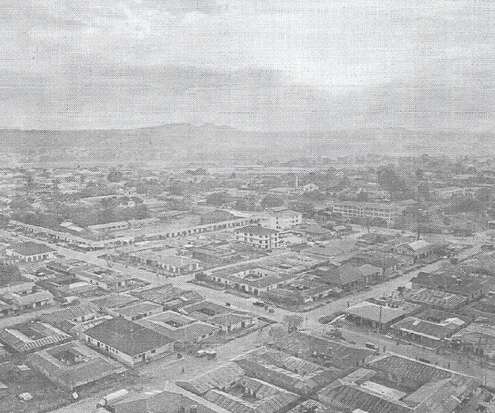 |
- With two evidence name the type of photograph
- With evidence from the photograph mention the type of transport seen on the area
- With evidence suggest the time when the photograph was taken
- Describe the type of settlement pattern shown
- Name two factors that might affect the quality of photograph
8. Clara was inside the house when she observed a house shaking due to vibration of Earth's surface caused by natural forces operating beneath the Earth's crust.
- Identify the environmental hazard observed by Clara.
- What is the name of the instrument used to measure the intensity of the hazard named in "A" above.
- Describe four (4) causes of the hazard named in "A" above.
- Explain three (3) effects of the hazard named in "A" above.
SECTION C (30 MARKS)
Answer only TWO questions from this section
9. " People move from their usual place to other places as they change their residence but most of them do not think that such a movement has effects". As an expert of population studies, how do you help them to understand the effect. Describe three effects of movement at the point of origin and three effects at the point of destination.
10. As a NEMC officer, you have been given an opportunity to conduct a seminar with the citizen on environmental pollution and mismanagement: Using six (6) points explain how you will advice the citizen on different ways for conserving the environment.
11. Kameleka's grandmother used to cultivate many crops in a small area using local seeds, and hand hoe and now she is blaming that she has been harvesting nothing in five years and she is complaining that her neighbors are the one who cause this problem. Explain to her six (6) ways on how she can improve her farming system instead of complaining to her neighbors
|
|
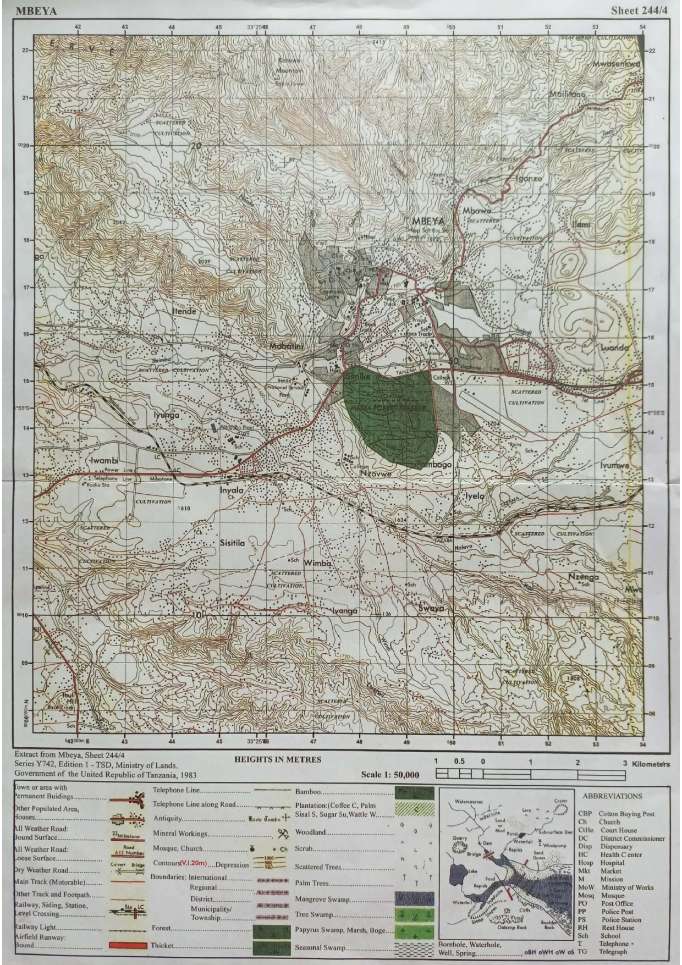
FORM FOUR GEOGRAPHY EXAM SERIES 122
FORM FOUR GEOGRAPHY EXAM SERIES 122
PRESIDENTS OFFICE REGIONAL ADMINISTRATION AND LOCAL GOVERNMENT
COAST REGION
FORM FOUR SECONDARY EDUCATION MOCK EXAMINATION
Code: 013 GEOGRAPHY
(For Both School and Private candidates)
Time: 3 Hours 2023
INSTRUCTIONS
- This paper consists of three sections A, B and C with a total of eleven (11) questions.
- Answer all questions in section A and B, and any TWO (2) questions from section C.
- Cellular phones and unauthorized materials are not allowed in the examination room.
- All writing should be in blue or black ink EXCEPT for drawings which should be in pencil.
- Write your Examination number on every page of your booklet (s).
SECTION A (16 MARKS)
Answer all questions in this section
1 . For each of the items (i) to (x), choose the correct answer from the given alternatives and write its letter beside the item number in the answer booklet provided.
i. Samweli is a form three student, he conducted a simple research about rocks, in his observation he saw some rocks expanding when get heated and contract when get cold, hence lose their outer part particles. What is the geological process observed by Samweli?
- Weathering
- Block disintegration
- Exfoliation
- Frost action
- Rock fall
ii. Mr. Manji was passing through different streets going at his home then he observed bending of the fences and trees around that area. Through which mechanism does this happen?
- Landslide
- Soil erosion
- Rock fall
- Soil creep
- Talus creep
iii. It is believed that the earth is not stationary; it rotates on its axis and revolves around the sun. Which one among the following is a result of its rotation? ![]()
- Eclipses
- Seasons of the year
- Aphelion and perihelion
- High and low tides
- Varying in length of day and night
iv. There are several heavenly bodies in the universe. As an astronomist to be, how would you name the heavenly bodies that are solid and revolve around the sun?
- Meteors
- Planets
- Asteroids
- Comets
- Meteorites
v. A football started in town X 200N300W at 1:00 pm, what would the time a town Y at 300S160W?
- 1:56 pm
- 7:40 am
- 1:56 am
- 1:40 pm
- 1:59 am
vi. Any pollution in the environment affects living things including human beings, other pollutions affect human hearing ability even heart failure. What kind of pollution leads to such impacts?
- Water pollution
- Land pollution
- Air pollution
- Noise pollution
- Soil erosion
vii. There are many transport systems that transport goods, human beings and animals. What is the type of the transport system uses to transfer liquid and gaseous products?
- Railway transport
- Pipeline transport
- Human transport
- Animal transport
- Air transport
viii. Geologists use the chart for dating the history of the earth including its rocks. As a form four student help your fellow form three students to identify such kind of the chart,
- Carbon 14
- Periodic table
- Geological time scale
- Measurement chart
- Richter scale
ix. One of the following earth's spheres is where the life takes place.
- Hydrosphere
- Atmosphere
- Biosphere
- Barysphere
- Troposphere
x. Diastrophism involves both lateral and vertical movement of the earth's crust. Which term among the following do geologists communicate about the downward or upward movement of the earth's crust?
- Internal earth's movement
- External earth's movement
- Radial movement
- Lateral movement
- Lateral movement and vertical movement
2. Match the items of the components of the solar system in list A with correct response in list B by writing the letter of the answer in booklet.
| LIST A | LIST B |
|
|
SECTION B (54 Marks)
Answer all questions in this section
3. Study the map extract of Mpwapwa (sheet 163/4) and answer the following questions.
a) Determine the size of the area covered by the forest found between eastings 150 and 220 and south of nothing 900.
b) What kind of vegetation is dominating the area?
c) Suggest four methods used to present relief features on the mapped area.
d) Give the bearing of Veterinary Research Institute at grid reference 224995 to Mpwapwa Teachers Collage at grid reference 203978.
e) With evidences of the map, suggest two social services found at the mapped area.
4. A geography teacher provided a test to her class of ten students. Students scored the following marks: 60, 40, 68, 35, 40, 51, 49, 69, 32, 73. Study the data and answer the following questions.
- Identify a mode
- Find the median
- Group the given data into the class interval of 10 starting with lower class of 30 marks.
- Briefly explain four types of line graphs that are used to present data.
5. The Ministry of Education of United Republic of Tanzania under National Examination Council of Tanzania past five years was in a research about why there was mass failure of pupils in primary schools. This made the government to take sample schools to make a research.
a) As a student who studied a research topic, give only five reasons why the ministry decided to use sample of schools to complete its research instead of taking all primary schools?
b)(i) Briefly explain the tool of data collection that is bias and it suits only to literate people or respondents.
(ii) Which tool needs a researcher to create a friendship atmosphere with a respondent before starting the collection of data?
6. One day Masumbuko was traveling to Morogoro, when he reached at Kibaha he saw road engineers carrying a chain, arrows, notebook, pencil, pegs and cross staff.
- Name three kind of obstacles that may hinder road engineers in carrying out surveying process,
- Identify three sources of mistakes that may occur during their survey process.
- Explain three significances of the type of the survey method which is done by the road engineers.
7. Mr. Juakali was digging a septic tank (hole) at his home. As he was proceeding he observed the changes on the arrangement of the soil in layers from the top to the bottom. As a pedologist explain to Mr. Juakali with the aid of diagram about such layers.
8. Carefully study the photograph then answer the following questions below.
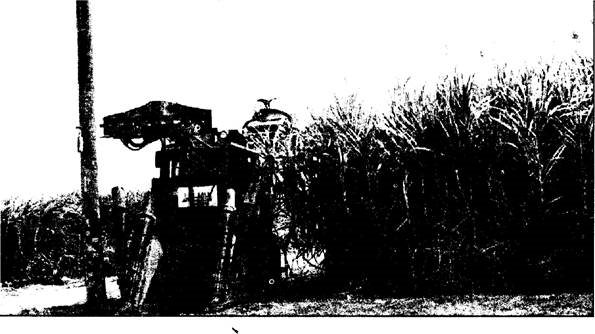
- Name the crop shown on the photograph.
- What is the activity taking place on the photograph?
- With evidence, suggest the scale of production of the crop shown.
- List down three conditions necessary for the growth of the crop shown on the photograph.
- Outline two factors that might affect the quality of the photograph.
SECTION C: (30 Marks)
Answer only two (2) questions in this section.
9. Juma as a tourist, he knows that tourism sector is a vital tool for the development of any country. One day he decided to visit some Tanzania National Parks but he noticed that there are some efforts that need to be taken. What do you think are the efforts to be taken by the Tanzanian government to make it more potential? (Six points)
10. Plantation is the most form of agriculture practiced in tropical regions of Africa, Asia and South America. Justify six characteristics of plantation practiced in these areas.
11. Many people change settlement location from one place to another either temporarily or permanently, others move involuntarily due to many reasons. Give six reasons to argue for the statement given.
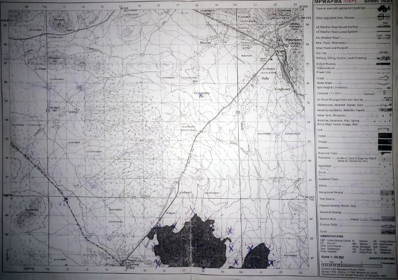 |
FORM FOUR GEOGRAPHY EXAM SERIES 112
FORM FOUR GEOGRAPHY EXAM SERIES 112
Candidate�s Index Number . . . . . . . . . . . . . . . . . . . . . .
THE UNITED REPUBLIC OF TANZANIA�THE PRESIDENT�S OFFICE�REGIONAL ADMINISTRATION AND LOCAL�GOVERNMENT
TANGANYIKA DISTRICT COUNCIL

FORM FOUR MOCK EXAMINATIONS
013 GEOGRAPHY
Time: 3:00 Hours April, 2023
INSTRUCTIONS�
- This paper consists of three sections A, B and C with a total of eleven (11) questions.
- Answer all questions from Section A and B and two (2) questions from section C.
- Section A carries sixteen (16) marks, Section B fifty four (54) marks and Section C carries thirty (30) marks.
- Map Extract of SIKONGE�(Sheet 137/2).
- Programmable calculators, cellular phones and any unauthorized materials are NOT allowed in the examination room.
- Write your Examination Number on every page of your answer sheets.�
SECTION A (16 marks)
Answer all�questions in this section
1. For each of the items�(i) � (x), choose the most correct answer from among the given alternatives and write its letter beside the item number in the answer sheet(s) provided.
(i) Suppose you want to carry out a field study on atmospheric conditions suitable for growth of cotton on a school farm. What are the basic weather components too be considered?
- Rainfall and wind
- Pressure and humidity
- Moisture and sunshine
- Rainfall and temperature
(ii) The Tanganyika District Meteorologists announce the temperature of Pwani 100m above the sea level is 29� C. What will be the temperature of Mpanda 800m above the sea level?
- 24.8 �C�
- 32� C�
- 33.2� C�
- 4.2� C
(iii) Mr. Mayala is a Small scale animal keeper at Skonko Village. He has four cows and he normally uses a rope to tie them to the post at one and the other side being tied to the cow�s leg. Which process is this?
- Zero grazing
- Normadism
- Transhumance
- Sedentary
(iv) Madam Hesa was passing through different streets going at home and then she saw bending of fences and trees around that area. This happens due to which mechanism?
- Soil creep
- Mudflow
- Rock fall
- Landslide
(v) Which one is a major environmental problems facing most of African cities?
- Loss of biodiversity
- Soil erosion
- Air pollution
- Deforestation
(vi) People of Bukoba District experienced shaking of crustal rocks which led to the destruction of properties and death of people. Where this shaking does originated inside the earth�s crust?
- At the epicenter
- At the focus
- At the seismic waves
- At the fault
(vii) The boundary that separates the mantle and crust is termed as:
- Mohorovicic discontinuity
- Gutenberg discontinuity
- Conrad discontinuity
- Atmosphere
(viii) In de jue, one among the following can be done:
- People who stay in the household for the night are counted.
- Is only done after five years.
- Only permanent members of households are counted.
- Only done after every ten years.
(ix) The BBC broadcast channel is conducting an interview at Alaska 75� W at 7:30 PM Tuesday, at what time and day will the people in Katavi Region 45� E be listening to the interviewed?
- 9:30 PM Tuesday
- 3:30 AM Wednesday
- 12:30 PM Tuesday
- 11:30 PM Wednesday
(x) A feature you would not see in Tanga � Tanzania Amboni caves.
- Levees
- Underground rivers
- Natural pillars
- Stalagmites
2. Match the item in Column �A� with the responses in Column �B� by writing the letter of the correct response beside the item number in the answer sheet(s) provided.
| COLUMN A� | COLUMN B |
| (i) Is the arrangement of soil on the slope from the top to the bottom.� (ii) Refers to the empty spaces between particles of the soil materials especially which is undistributed. (iii) Is the vertical section from the surface to the parent rock characterized by distinct layers. (iv) Acidity or alkalinity used to determine the amount of hydrogen ions in the soil. (v) Is the arrangement of the soil particles into aggregate compound particles.� (vi) The process of washing down nutrients in the solution from top soil layer to subsoil layers. |
|
SECTION B (54 Marks)
Answer all�questions in this section.
3. Carefully study the Map Extract of SIKONGE (Sheet 137/2) provided, then answer questions that follow below:
|
(a) Identify the type of rocks found on the mapped area.
(b) Give two main human activities that are taking place on the mapped area.
(c) Calculate the distance of the Dry weather road from grid reference 738828 to 759882.
(d) Describe a relief found on the mapped area.
(e) Describe the main two functions of the settlements found at the South West of the mapped area.
4. (a) Sir Baraka recorded the outcome of his student�s performance in Geography weekly test as follows: 8, 22, 18, 16, 8, 4, 18, 10, 15, 16, 20, 16, 21, 4, 18, 13, 22, 12, 30, 23, 10, 20, 15, 6, 16, 8, and 2. Can you help Sir Baraka to find the following?
- Mean
- Mode
- Median
- Range
(b) With two examples, show the application of the statistical data in daily life at (a) above.
5. Lilian is working in women affairs institution. She decided to conduct a research on the effects of abortion on academic performance for girl students in Katavi Region. She selected only five schools to represent others and then ten girl students were chosen from each school to be used as samples under study.
- What will be the best research approach for her study?
- Name the sampling technique used by Lilian.
- Give two reasons for why Lilian decided to use sample in her research?
- State two uses of her research output.
- Suggest two constraints which possibly faced her collecting date.
6. If you are given a task to conduct a chain survey around your school compound. What are the main three procedures you would use to carry out the task?
7. Study the following photograph and answer the questions that follow:
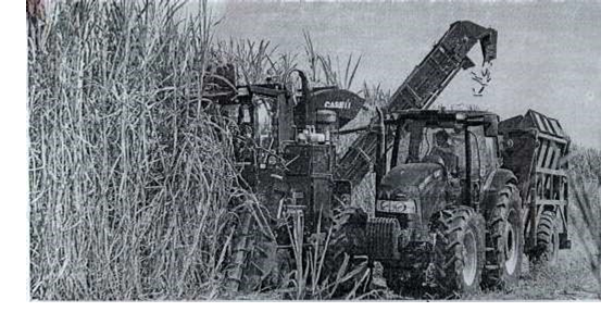 |
- Name the crop shown on the photograph.
- What is the activity taking place on the photograph?
- With one evidence, suggest the scale of production of the crop shown.
- List down two conditions necessary for the growth of the crop shown on the photograph.
- Outline two factors that might affect the quality of the photograph given.
8. (a) What is a river capture?
(b) With a well labeled diagram, show features formed in (a) above.
SECTION C (30 Marks)
Answer two (02) questions from this section
9. Population distribution in Tanzania is unevenly. Elaborate this statement by using six points.
10. Most of places in Tanzania are facing the problem of rainfall shortage. You as Geography expert, explain six ways that can be applied to find the solutions for the existing problem mentioned.
11. Tanzania government currently is in construction of Standard Gauge Railway (SGR) from Dar es Salaam to Morogoro, Dodoma, Singida, Tabora, Kigoma and Katavi. As among Tanzanian youths, explain six benefits of such project to the young generation in Tanzania.
FORM FOUR GEOGRAPHY EXAM SERIES 105
FORM FOUR GEOGRAPHY EXAM SERIES 105
THE UNITED REPUBLIC OF TANZANIA PRESIDENT'S OFFICE REGIONAL ADMINISTRATION AND LOCAL GOVERNMENT
TANGA REGION
FORM FOUR MOCK EXAMINATION
013 GEOGRAPHY
(For Both School and Private Candidates
TIME: 3 HOURS MAY 2023
Instructions
- This paper consists of sections A, B and C with a total often (10) questions.
- Answer all questions in section A and B and two (2) questions from section C.
- Section A carries fifteen (15) marks, section B fifty five (55) marks and section C carries thirty (30) marks.
- Maps extract of ILONGA (Sheet 265/2) is provided
- Programmable calculators, cellular phones and any unauthorized materials are not allowed in the examination room
- Write your examination number on every page of your answer bo)oklet(s).
SECTION A (15 MARKS)
Answer all questions in this section
For each of the items (i) — (x) Choose the correct, answer from among the given alternatives and write its letter besides the item number in the answer booklet(s) provided.
(i) Mr. John visited a certain farmer where he observed some cattle being kept in fenced area with small farm in it for pasture. Which of the fanning system Mr. John observed?
- Subsistence farming
- Sedentary farming
- Zero grazing system
- Nomadic pastoralism
- Semi Sedentary agriculture
(ii) Suppose someone asked you about salinity of ocean water, you will tell him/ her that the salinity of ocean water increases with.
- Distance from Equatorial region
- Depth of sea water
- Increase rate of evaporation of ocean water
- Altitude
- Increasing rainfall
(iii) Jane and Neema were wondering about a very large population in small area when they visited Dar es Salaam City. What is the best term used to express the situation observed?
- Population explosion
- Population pressure
- Overpopulation
- Population density
- Optimum population
(iv) Students from Duga secondary school went to Kilimanjaro for study tour for the aim of climbing mount Kilimanjaro. At the foot of the mountain 800m they noticed the temperature of 22 0C . What will be the temperature when they reached at the Kibo peak 4500m above the sea level?
- 44.20C
- 0.6°C
- - 0.20C
- 22°C
- 22.2°C
(v) Suppose you are working at national Environmental management and conservation (NEMC) and you were asked by Radio UFM to educate society about Conservation measures against pollution of underground water. Which are among the following could be the best alternatives?
- The waste should be dumped under ground
- The acidity in the ground should be added
- Farmers should be encouraged to use industrial fertilizer
- The waste should be recycled
- Deforestation should be encouraged
(vi) Mr. Majaliwa is working at Airport where he used to observe the direction of wind from East South East, his interest was to determine the compass bearing of the wind direction. Among the given alternatives which is the best?
- 450
- 2250
- 900
- D. 112½0
- E.67½0
(vii) Madam Rose does not know why the Earth rotates for a very high speed but its materials remain stable on the earth without moving or shaking as a geographer, what is the main cause for such phenomena?
- Rotation of the earth
- Force of gravity
- Revolution of the earth
- The influence of tides
- Deflection
(viii) Simba verses AS Vital played CAF football match competition in Dar es Salaam 450 E , Yanga scored a goal at 7:30 PM. At what time people in Liberia 150 W will see the goal on Television?
- 3:30 PM
- 11:30 AM
- 11:30 PM
- 6:30 PM
- 3:30 AM
(ix) The Maasai around Oldonyo Lengai mountain were wondering the way the mountain was ejecting fire and smoke. They believed that the mountain was possessed by bad evil spirits. Tell them what geological process that was taking place.
- Volcanicity
- Volcanic eruption
- Volcanism
- Magma
- Lava
(x) Farmers at Kwamdulu Village invited Agricultural officers to give knowledge on the kind of good soil for growing maize one of the knowledge he provided -was about rocks permeability. Assume you are the invited, what would you tell the farmers about permeability of rocks
- The ability of rock to hold water'
- The ability of the rock to allow water to enter
- The rate at which water enters the rock
- The ability of a rock to hold nutrients for a long time
- The ability of rock to allow water to pass through
2. Match the letter on the correct response beside the item number in the answer booklets provided
| LIST A | LIST B |
|
|
|
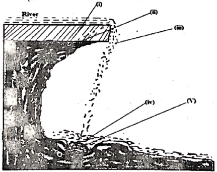
SECTION B (55 MARKS)
Answer all questions in this section
3. Study the map extract of ILONGA ( Sheet 265/2) and answer the following questions.
- Measure the distance covered by the river in kilometer from grid reference 630000 to 600979
- By using the square method calculate the area covered by Namihono pond.
- With evidence, mention three economic activities which may be conducted on a mapped area.
- Describe the nature of the relief of an area.
- With reasons, suggest the type of climate on mapped area.
- Identify three factors which have influenced population distribution of ILONGA town.
4. The District Agricultural officer at Mkinga collected the data on maize production for eight (8) years. The report was as follows
| Year | Maize Production "00" |
| 2001 | 220 |
| 2002 | 230 |
| 2003 | 280 |
| 2004 | 280 |
| 2005 | 240 |
| 2006 | 320 |
| 2007 | 290 |
| 2008 | 300 |
(i) Construct a divergence bar graph.
(ii) List down two merits and demerits of divergence bar graph.
(ii) Show other three (3) ways you can use to present the data
5. There was a land conflict between investors and the local people at Mkata village in Handeni District Council in Tanga Region. An expert of land survey from Ardhi University and inhabitant of the area decided to invite the survey team which is dealing with chain survey for a long time to determine and solve the conflict in the Village in accomplishing their survey, the team realized that they have collected the data with discrepancies due to improper arrangement of the poles.
- What does the term "Discrepancies" as used in chain surveying means?
- What type of discrepancy the surveying team encountered
- Identify three (03) people who are involved to form Surveying team
- Describe two (02) major instruments used to measure distance in chain survey
6. Mariam is the form four student from Tanga City, during the holiday she went to visit his uncle in Dar es Salaam, when she was there she saw a lot of children with no parents and place to live, some were sleeping in bus stand others in the market, she decides to conduct research about this situation.
- Suggest the proper research problem for this research
- Identify any source of that research problem
- Suggest three possible research tools she would use to conduct her research
- Choose one research tool from above, show two advantages and disadvantages
7. Carefully study the photograph below and then answer the questions that follow
- What type of photography is this? Give reasons.
- At what time the photography was taken? Why?
- Comment on the topography of the area
- With evidence describe the type of settlement of the area.
- A part from providing shade explain other three advantages of the vegetation on the photograph.
SECTION C. 30 MARKS
Answer any two (02) question from this section
8. In Tanzania suppliers fail to transport various goods to all parts of the country. As a geographer suggest what should be done to address the challenges facing_ transport sector in Tanzania .Give five (05) points.
9. Most of African countries established birth control and international migration policy as the among of methods of controlling rapid population growth. As a form four, student, do you think there is any problem of population increase in these countries? Give six points.
10. A Geography teacher at Mkwakwani secondary school taught his students that " Soil has physical, chemical and biological properties? With facts and vivid examples, you as an expert in geography clarify (05) five physical properties of soil which were taught by the geography teacher.
|
|

FORM FOUR GEOGRAPHY EXAM SERIES 97
FORM FOUR GEOGRAPHY EXAM SERIES 97
PRESIDENT'S OFFICE REGIONAL ADMINISTRATION AND LOCAL GOVERNMENT
KILIMANJARO REGIONAL COMMISSIONER'S OFFICE
FORM FOUR MOCK EXAMINATION
GEOGRAPHY
CODE: 013
TIME: 3 HOURS 28/06/2022
INSTRUCTIONS
- This paper consists of sections A, B and C with total of ten (10) questions
- Answer all questions in section A and B and any two (2) questions in section C.
- Section A carries fifteen (15) marks, section B fifty five (55) marks and Section C
carries thirty (30) marks. - Cellular phones, programmable calculators and any unauthorized material are not allowed in the examination room.
- Map sheet of Kasamwa (sheet 3214 ) is provided..
- Write your examination number on every page of your answer sheet(s).
SECTION A (15 Marks)
Answer all questions in this section
I . For each of the items (i-x), choose the correct answer from among the given alternatives and write its letter beside the item number in the answer sheet provided:
(i) The Earth's shape is flattered sphere which is called;
- Geodic
- Globe
- Galaxy
- Spheroid
- Cyclic
(ii) Rambo used to see a group of herdsmen moving periodically with their cattle between lowlands and highlands in search for water and pasture. Which term refers to such movement?
- Pastoralism
- Zero grazing
- Transhumance
- Nomadism
- Destocking
(iii) It was a wonderful event after several years when a river becomes young again in its valley. Identify the process that took place
- Regime
- Delta
- Capture
- Abrasion
- Rejuvenation
(iv) Fold Mountains are the result of
- Compressional forces
- Faulting
- Folding
- Tensional forces
- Tilting
(v) The industry which deals with making new products from the processed raw materials is referred to as:
- Fabricating industries
- Light industries
- Processing industries
- Manufacturing industries
- Decortication industries Page 2 of 6
(vi) The President of the United Republic of Tanzania was addressing the Nation at noon in Dar es Salaam 45°E. At a time, Tanzanians in the Diaspora were streaming the speech live from England at 08:00am. What was the longitude of England?
- 15°E
- 15°W
- 60°E
- 60°W
- 75°W
(vii) Tanzania used to conduct her National census after every ten years which type of census is this?
- Decennial census
- De Facto census
- De jurecensus
- Quinquennialcensus
- National census
(viii) What is the socio-economic advantage of reserved forests to the society?
- Tourism
- Mining
- Lumbering
- Forestry
- Agroforestry
(ix) Mr Maurice and his colleagues enjoyed the temperature of Mtwara which was 32°C at sea level.
They had a plan to travel to visit Babati for their vacation which is 1500m above the sea level. What will be the temperature they expect to experience during their visit in Babati?
- 23°C
- 41°C
- 0.6°C
- 9 °C
- 20°C
(x) The extensive highland areas with more or less uniform summit level bounded by one or more steep slope side is called:
- Hill
- Plateaus
- Residual
- Basin
- Horst
2. Match the description of extrusive volcanic features in Column A with corresponding feature in Column B by writing the letter of the correct answer beside the item number in the answer sheet provided:
| Column A | Column B |
| (i) A pillar like feature formed when a mass of very (ii) A funnel-shaped volcanic depression formed at (iii) A natural hot spring from the ground that discharges steam and hot water into the air (iv) An enlarged volcanic depression formed by denudation activities on small depression or further eruptions. (v) A volcanic feature where steam, mud and several gases are emitted. |
|
SECTION B: (55 Marks)
Answer all questions in this section
3. Carefuly study the map extract of Kasamwa (sheet 32/4) provided and answer the following questions;
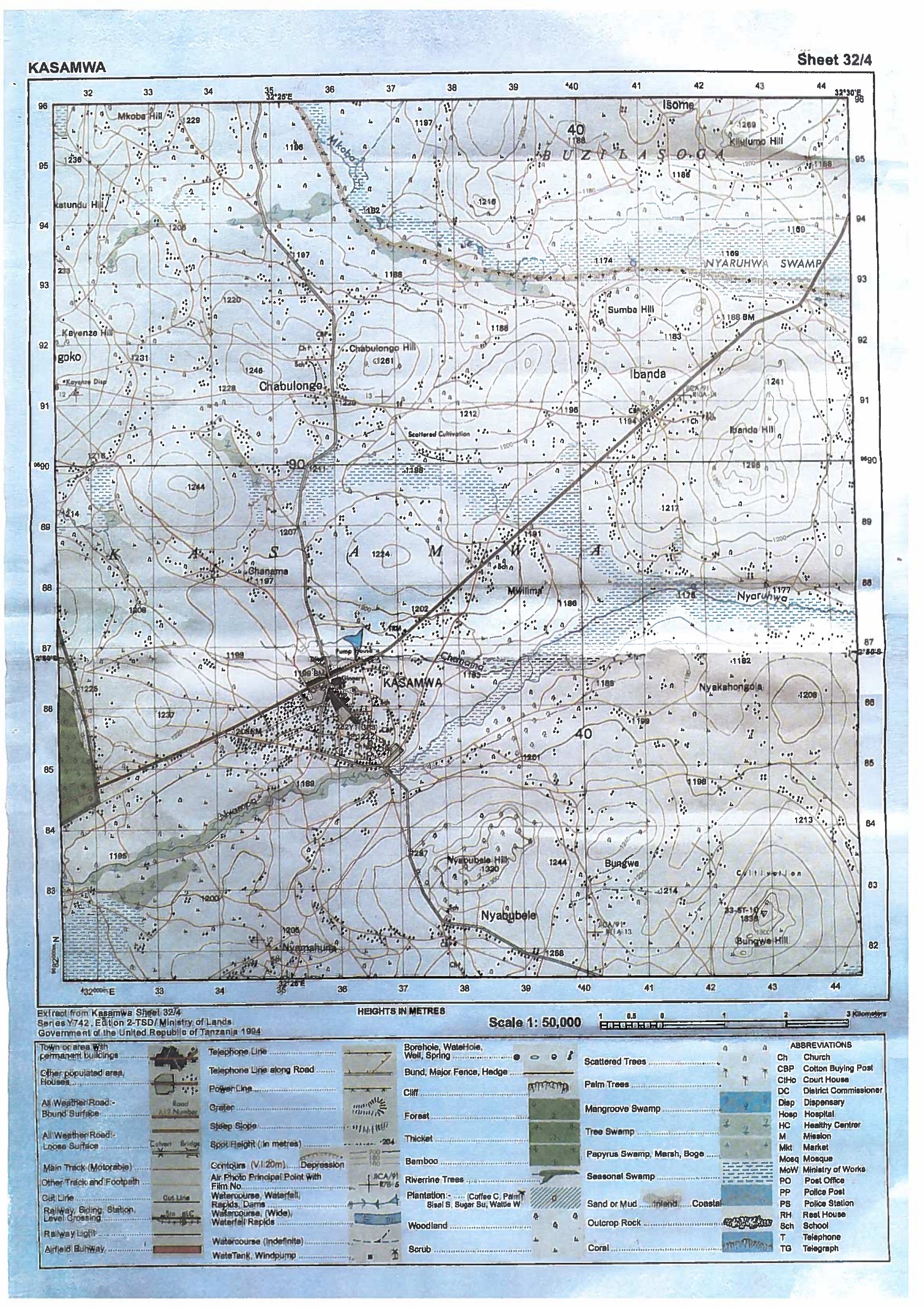 |
- By giving concrete examples from the map, describe three (3) types of natural vegetation found on the mapped area.
- Use evidences to describe the types of settlement and nature of distribution patterns.
- Calculate the area of Eastern part of the mapped area from 38 easting using square method. Give your answer in square kilometers
- In which hemisphere is the mapped area located? Give evidence for your answer
- Suggest two (2) factors which could have affected the content of the map.
4. Maro and Kibwana are working in one of the village store as store keepers. They always record data for food crops ( in Kg) graphically. Use the graph they presented to answer the questions that follows:
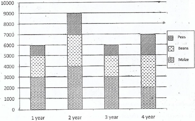 |
- Give the name of graph
- From the graph above, construct the variables table that they used to draw the graph
- State three (3) other applicable methods of presenting the same data
- List down five (5) main procedures can be followed to present the data graphically
5. (a) What is sampling as applied in research?
(b) Explain four (4) probability sampling techniques as applied in research.
(c) Miss Helen decided to conduct a research on why Ochilo district has ranked the last in National Examination results. She decided to visit a Regional-Library before going to the actual field work. Provide six (6) reasons for Miss Helen's visit to the Regional Library.
6. Bwana Mavunde is a good surveyor; he intended to construct a football playing ground in Dodoma city.
(a) Suggest the surveying technique suitable for his project
(b) Identify main two (2) equipment that would be useful in this project
(c) Give, four (4) significance ofthe method you identified in (a) above
(d) Identify and explain three (3) types of errors he may encounter off.
7. Carefully study the photograph below and answer question that follows:
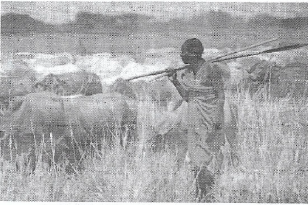 |
- Name the activity taking place in the photograph
- Give three (3) importance of the activity you have named to the economy of the country like Tanzania.
- With two (2) reasons suggest the type of photograph showed above
- `What are the three (3) negative impacts of the activity to the environment?
- What is the scale of the activity you have named in (a) above
SECTION C (30 marks)
Answer any two (2) questions from this section
8. Suppose you are appointed by the President Samia Sulu Hassan to be the campaign manager to mobilize Tanzanians to participate fully in National Census of August 2022.Use six (6) points to show how you will convince each individual to participate in the national enumeration.
9. "Economic growth can be accelerated by industrialization". As an educated person, demonstrate to your community on how industries promote economic growth of individual and nation at large? (Use six (6) points).
10. Hydro-Electric power has been a backbone of energy supply in Tanzania for a long time. Explain in six (6) points, why Tanzania takes long time to establish hydro Electric power at Rufiji River Basin (Stigler's Gorge Power Plant)?
FORM FOUR GEOGRAPHY EXAM SERIES 39
FORM FOUR GEOGRAPHY EXAM SERIES 39
ORGANIZATION OF HEADS OF NON – GOVERNMENT SECONDARY SCHOOLS (OHONGSS)

KIGOMA
FORM FOUR REGIONAL MOCK EXAMINATION 2022
CODE 13 GEOGRAPHY
TIME : 3 HOURS JUNE 2022
INSTRUCTIONS
- This paper consists of three sections A, B and C with a total of 10 questions.
- Answer all questions in section A and B and any two (2) questions from section C.
- Map Extract of Mbeya (sheet 244/4) is provided.
SECTION A (15 MARKS)
Answer all questions in section
1. For each of the items (i) - (x), choose the correct answer from among the given alternatives and write its letter in the answer sheet (s) provided
i) Which of the following planets is closest to the sun?
- Earth
- Jupiter
- mars
- Mercury
- Neptune
ii) Overgrazing in Tanzania can lead to environmental problems. Identify the regions might have been affected by the problem;
- Dodoma, Arusha and Shinyanga
- Morogoro, Dar es salaam and Tanga
- Pwani, Mbeya and Rukwa
- Mwanza , Singida and Tabora
- Manyara , Iringa and Dodoma
iii) Edvan at Panda Hill Secondary School had an interest in conducting a geographical research on challenges street children face in cities. What will be the last stage for his research?
- Data collection
- Data presentation
- Report writing
- Data analysis
- Data processing
iv) when the moon’s shadow casts over the earth’s surface the phenomenon is known as
- Lunar eclipse
- Solar eclipse
- Equinoxes
- Summer solstice
- Winter solstice
v) What are the four types of statistical data basing on their nature?
- Individual data, discrete data, raw data and secondary data
- Individual data, discrete data , grouped data and continuous data
- Primary data, secondary data, grouped data and collective data
- Individual data, grouped data, statistical data and discrete data
- Raw data, continuous data , primary data and array data
vi) The minimum and maximum temperature recorded is used to calculate;
- Daily range of temperature
- Annual temperature
- Monthly temperature
- Alcohol temperature
- Relative temperature
Vii) Rain water which flows on the surface without following a proper channel is called
- Groundwater
- River
- Runoff
- Spring
- Well
viii) Suppose you are asked to identify the sources of physical hazards. Which among the following is the best answer?
- Pathogenic bacteria
- Social – cultural practices
- Skin contact with acids
- Drug abuse
- Solar radiation
ix) Mr. Bakari is a peasant at Ifakara in Morogoro who applies proper methods of farming. Identify some proper methods of farming Mr. Bakari uses which suit him
- Terracing, overgrazing and contour ploughing
- contour ploughing, crop rotation and mulching
- Recycling, bush fallowing and terracing
- Terracing, overgrazing and crop rotation
- Shifting cultivation, terracing and overstocking
x) Which among the following atmospheric gases is not one of the greenhouse gases?
- Carbon dioxide
- Carbon monoxide
- Methane
- Nitrous oxide
- Chlorofluorocarbon
2. Match the descriptions of Population concepts provided in LIST A with their corresponding
Concepts in LIST B by writing the letter of correct answer in the sheet(s) provided
| LIST A | LIST B |
|
|
SECTION B (55 MARKS)
Answer all questions in section
3. Carefully study the map exact of Mbeya (sheet 244/4) provided, then answer the following
 |
Questions;
- By giving evidence from the map, describe two methods used to show relief on the mapped area.
- With supporting evidence from the map, name four social economic activities carried out in the area.
- Name any two ways of expressing the scale of the map that have been used.
- Measure the length of the road from grid reference 425130 to 448131 in kilometers, if Khamis covered the area by a bus and turned back
- Giving examples, describe the major types of transport of the mapped area
4. Carefully study the weather data for a station in Australia and answer the questions that follow;
| Month | J | F | M | A | M | J | J | A | S | O | N | D |
| Temp(oc) | 28.3 | 27.5 | 28.5 | 29 | 26.7 | 26 | 26 | 25 | 24 | 26 | 27 | 28 |
| Rainfall (mm) | 380 | 330 | 240 | 175 | 175 | 5 | 2.5 | 2.2 | 17 | 50 | 210 | 230 |
a) Calculate the annual mean temperature for the station
b) Determine the rainfall range
c) Calculate the mean daily temperature
d) Present the temperature and rainfall distribution in a simple graph
e) Identify the type of the climate of the station
5. Suppose you want to conduct a research about a certain issue as directed by your research class teacher
i)Outline any seven steps to be followed chronologically
ii) List down any five advantages of research output in the society.
6. There was a serious conflict between farmers whose plots was nearby each other. They tried to resettle the conflict but they failed and later on they decided to consult the Village Executive Officer to seek the resolution. The Village Executive Officer decided to send the village land resolution team to the field. The team decided to use the method of linear measurement.
- Identify the method of taking measurement used
- List down any four instruments that were used
- If the team consisted of three personnel’s in taking linear measurement. Who are those?
- Describe any four significances of using the method identified in ( a) above
7. Study carefully the given photograph below then answer the questions that follow
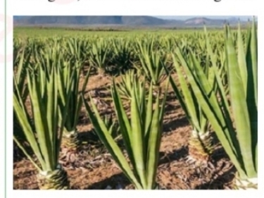
- What is the title of the photograph?
- State the scale of the production
- Outline any four regions in Tanzania where the photograph might have been taken
- What are the three necessary conditions that favour the growth of the crop shown on the photograph above?
- List down any four uses of the crop shown on the photograph
SECTION C (30 MARKS)
Answer any two questions in this section
7. You have met five Form Two students debating that the current modification of infrastructures In Dar es Salaam is wastage of public funds as long as the capital city is officially in Dodoma, basing on the settlement functions of Dar es Salaam city, explain how you would Convince them on the importance of developing its infrastructures.(provide any six points)
8. Population over the earth’s surface is not evenly due to different factors. Describe any six factors for uneven population over the earth’s surface
9. Kawaida’s grandmother believes that studying of Geography in the current globalized world is wastage of time since each and everything can be accessed through social networks, television or internet. By giving six points with vivid examples proof that studying of Geography is significant in our daily life.
FORM FOUR GEOGRAPHY EXAM SERIES 32
FORM FOUR GEOGRAPHY EXAM SERIES 32
THE UNITED REPUBLIC OF TANZANIA PRESIDENT’S OFFICE - REGIONAL ADMINISTRATION AND LOCAL GOVERNMENT
LUDEWA DISTRICTCOUNCIL
FORM FOUR MOCK EXAMINATION 2022
013 GEOGRAPHY
(For Both School and Private Candidates)
Time 3:00 Hours 6th JUNE 2022
INSTRUCTIONS
1. This paper consists of sections A, B and C
2. Answer all questions in section A and B and two (2) questions from section C.
3. Section A carries fifteen 15 marks, sections B fifty five (55) marks and section C carries thirty (30) marks
4. Map extract of Lembeni (sheet 73/3) is provided
5. Programmable calculators, cellular phones, and any unauthorized materials are not allowed in the examination room.
6. Write your examination number on every page of your answer booklet (s)
SECTION A (15 MARKS)
Answer all questions in this section
1. For each of the following items (i) - (x) choose the correct answer and write its letter beside the number
i.Mr. Majaliwa wanted to dig a dam for the purpose of obtaining water of his goats and garden during dry season, but he did wrong and he dug on the area with the rocks which allow further percolation of the water. As skilled geography student do you think Mr. Majaliwa he dug his dam on which type of rocks?
- Permeable rocks
- Hard rocks
- Soft rocks
- Impermeable rocks
- Igneous rock
ii.Marry is form four student in Kaloleni secondary school, he was given task by her teacher to measure a road on map from Iringa to Dodoma, which instrument would you advice marry in order to get accurate measurement of a given road on a map?
- Pair of divider
- Pair of scissors
- A thread
- Ruler
- Razor blade
iii. Assume you have given a task to identify the proper arrangement of the first five planets of the solar system according to the distance from the sun starting with the nearest planet. Which one of the following set will be the best set of arrangement of the first five planets of the solar system?
- Mercury, Earth, Venus, Saturn, and Mars
- Mercury, Venus, Earth, Mars and Jupiter
- Venus, Mercury, Mars, earth and Venus
- Mars, Earth, Mercury, Jupiter and Venus
- Mercury, Jupiter, Earth, Venus and Uranus
iv.Basing on knowledge you have acquired in class when you are studying geological time scale, what was the geological event that took place in Jurassic era?
- Volcanic activity
- Deposition of marine surface sediments
- Ice age mountains
- Down warping of the earth’s
- Glaciation of east African
v.The T.M.A announced the temperature of Dar es Salaam 100 meter above the sea level is 290C. What will be the temperature of Dodoma 800 meter above the sea level?
- 33.20C
- 20.80C
- 320C
- 24.80C
- 4.20C
vi. According to approach there are two types of census which are de facto and de jure. Do you think which among of the following series of distractors is true about de jure census?
- people who stay in the household for the night are counted
- is only done for every five years
- only permanent members of the household are counted
- is only done for every ten years
- only people who died are counted per household
vii. Asha is farmer from Nguvumali village, he went to agricultural officer to ask on type of soil with clearly distinguishable horizons which occur in definite regions of climate and vegetation. Which of the following type of the soil which Asha asked to agricultural officer?
- Intrazonal
- Zonal soil
- Ozonal soil
- Clay soil
- Desert soil
viii. Miriam she failed to identify the type of tropical climates that have the largest diurnal temperature range after being asked by his young sister? Which of the following will be the best answer for question asked to Asha?
- Tropical monsoon
- Mediterranean climate
- Hot deserts
- Equatorial climate
- Cold deserts
ix. Taifa Stars scored a goal against Malawi in Town Y 150E at 4:00 pm. At what time will commentator at Town X 630W will communicate a goal?
- 4:47 pm
- 10:48 am
- 11:12 am
- 1:48 pm
- 6:12 pm
x.Junior he visited at lower section of Ruaha River found in Iringa, but he observed various features at that stage of river. Do you think which among the following are examples of features might be observed by Junior?
- Ox-bow lake, U-shaped valley and interlocking spur
- Meanders, alluvium and U-shaped valley
- Meanders, deposition and flood plain
- Braided rivers, distributaries and delta
- Braided rivers, distributaries and arête
2. Match the items in LIST A with the response in LIST B by writing the letter of the correct response beside the item number.
| LIST A | LIST B |
| i. Large depression formed when several doline collapse ii. Irregular groves formed when water erodes the cracks in the karst region iii. Underground chambers formed due to dissolving of limestone rocks iv. Stumpy rock masses that grow from the floor of the chamber upwards v. The vertical shaft of the hole from the surface into the ground |
|
SECTION B 55 MARKS
Answer all questions in this section
3. Study the map extract of Lembeni (sheet 73/3) then answer the following questions
 |
a) Calculate the area of the whole map of Lembeni in Km2 by using grid square method
b) By evidences suggest any four (4) economic activities that might be taking place in the area
c) Calculate length of all-weather road from grid reference 468762 to 542782 in Km d)In which hemisphere is the mapped area is located?
e) Describe four (4) drainage pattern of the area.
4. Study carefully the data below that show the enrollment of form six students at Bagamoyo secondary school from 1980-1985 the answer the questions that follows;
| YEAR | NUMBER OF STUDENTS |
| 1980 | 100 |
| 1981 | 150 |
| 1982 | 175 |
| 1983 | 200 |
| 1984 | 225 |
| 1985 | 300 |
a) present the data above by pie chart
b) comment on the trend of the pie chart in (a) above
c) What are the merits of using this method Apart from that method use in (a) above. Give three (3) points
d) What are alternative methods that can be used to present the data above? Give two (2) points.
5. The geography Teacher of Galanos Secondary School taught his student’s survey topic theoretically when they were in class room, the next day wants to do it practically and he told them to find the materials that will be used to draw the map of their school compound. The teacher wants one among of his student to go and demonstrate the procedure that will be used in their surveying process.
i. Suggest the type of land survey that will be used on their surveying process.
ii.Describe any five (5) instruments that will be used in the type of survey named (a) above. iii. What are the merits of the type of survey used in (a) above. Give three (3) points
iv. Do you think which methods of booking details in a field notebook used after they have been taken from the field while conducting surveying process? Explain two (2) those main methods used.
6. Suppose you want to conduct a research about millet production in your district from 2008 to 2018 and your interest is to know whether the production has increased or decrease. Your plan is to consult farmers who were directly involved in the maize production for the said period and visit the District Agriculture Officer for more information.
a) What will be the best research approach for your study?
b) Name the main source of data for your study.
c) Identify two (2) individuals who will be respondents for your study.
d) Mention other six (6) possible sources of research problem for the similar study
7. Study carefully the following photograph then answer the questions that follows
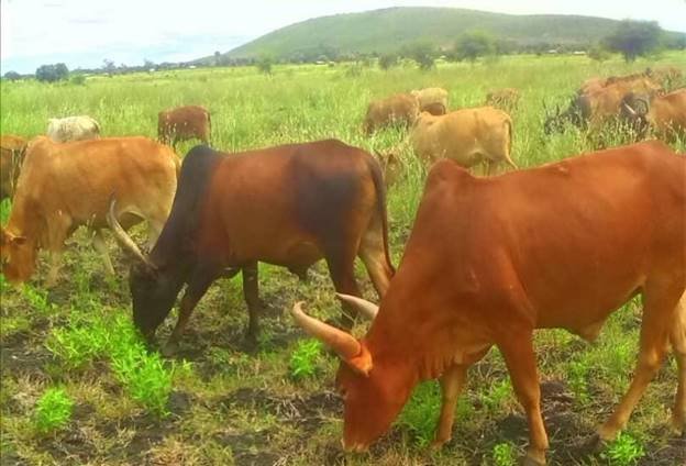 |
a) With two (2) evidences name the type of photograph shown
b) What is the activity taking place on the photograph?
c) By giving two (2) evidences, suggest the possible climate type whereby the activity you mentioned in (b) above is likely to taking place?
d) What will happen to the environment if the activity you mentioned in (b) above be conducted in large scale? Give four (4) points
SECTION C 30 MARKS
Choose only two questions in this section
8. “By destroying the environment man prepare for his own destruction” with example discuss this statement giving six (6) points.
9. Plantation is the most form of agriculture practiced in tropical region of Africa, Asia and South America. Justify six (6) characteristics of plantations practiced in these areas.
10. In the incoming year 2022, Tanzania is expecting to endure census. What are benefits that Tanzania government will gain after conducting census processes? With example provide six (6) points.
FORM FOUR GEOGRAPHY EXAM SERIES 12
FORM FOUR GEOGRAPHY EXAM SERIES 12
THE PRESIDENT’S OFFICE, MINISTRY OF EDUCATION, REGIONAL ADMINISTRATION AND LOCAL GOVERNMENT
ARUSHA REGIONAL MOCK EXAMINATION-MAY 2021
FORM FOUR
GEOGRAPHY
TIME : 3:00HRS
INSTRUCTIONS
- This paper consists of section A, B and C with a total of ten (10) questions.
- Answer all questions in section A and B and any two (2) questions from section C.
- Map extract of Kigoma (sheet 92/3) is provided.
- Programmable calculators, cellular phones and unauthorized materials are not allowed in the examination room.
- Write your examination number on every page of your answer booklet(s).
SECTION A
Answer all questions in this section
1 For each of the items (i — x), choose the correct answer from among the given alternatives and write its letter in the answer bracket (s) provided.
(i) The Earth have different evidences that proves that the Earth is spherical. What do you think that this is one among those evidences?
- The four seasons
- The lunar eclipse
- The revolution of the Earth
- The Earth rotation
- The eclipse of the sun
(ii) If the scale of a map is 1: 50,000 what will be the actual ground distance of a river with 18cm on a map?
- 91m
- 2km
- 18000km
- 4Km
- 900,000 km
(iii) The forceful emission of hot water from the ground into the atmosphere is known as
- Geyser
- Well
- Hot spring
- Pond
- Dyke
(iv) If the temperature at 950 metres is 240 C What is the temperature of Kilimanjaro 5895 metres above the sea level?
- 10.240 C
- 340 C
- 5.670 C
- 18.50 C
- 320 C
(v) A drainage pattern which works likc a trcc with its branches is called
- Radial
- Dendritic
- Centripetal
- Annual
- Trells
(vi) A vertical feature formed out of the solidification of magma within the Earth's crust is called
- Localita
- sill
- lopolith
- Dykc
- Phacolith
(vii) The process of peeling off of rock mass is called
- Disintegration
- Weathering
- Mass wasting
- Erosion
- Exfoliation
(viii) Various methods are used in the mining activities depending on the occurrence of the concerned mineral, easiness of the method and cost. The following are the common methods of mining except
- Strip method
- Placer method
- Open cast method
- Underground method
- Gold, zinc and copper
(ix) The following arc the element of weather
- Soils, clouds, dew, humidity, rainfall
- Pressure, clouds, sunshine, humidity, winds
- Fog, barometer, humidity, pressure, air mass
- Pressure, humidity, soil, fog, rainfall
- Clouds, sunshine, pressure, humidity, thermometer
(x) Form of metamorphism which affects large area with the influence of pressure only
- Contact metamorphism
- Dynamic metamorphism
- Local metamorphism
- Thermal metamorphism
- Diastrophism
2. Match the items in List A with the responses in list B by writing the letter Of the correct responses beside the item number in the answer booklet provided.
| LIST A | LIST B |
| (i) Fineness and coarsened of soil particles (ii) Removal of materials from the surface of the land (iii) Vertical section of the soil to the underlying rocks (iv) Status of soil with respect to amount elements necessary for plants (v) Residues that have decomposed and mixed with soil mass |
|
SECTION B ( 55 Marks)
3. Study carefully the map extract of Kigoma (sheet 92/3) and then answer the questions that follows.
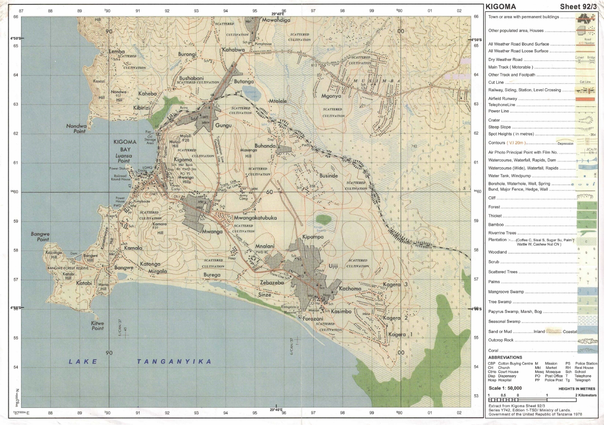 |
(a) Identity the features that found in the following grid references
- 923617
- 945599
- 910596
(b) Calculate the area of lake Tanganyika from 570 Southward. Give your answer in Km2
(c) What is the length of the railway line from grid reference 944633 Eastward. Give your answer in Km.
(d) With evidence suggest the type of settlement patterns depicted in the map.
(e) By providing evidences, explain three (3) human economic activities and two (2) social activities that might be taking place in the area.
4. The following table indicates scores of Geography weekly test for some form four students at Mwakalel Secondary School in 2021.
| Student's name | Mwantege | Mwaipya | Mwaitabete | Mwakatundu | Mwakabute |
| Sares | 70 | 50 | 70 | 80 | 40 |
(a) Present the data by means of divergence bar graph
(b) Give two merits and two demerits of the methods used.
5. (a) Mary is a good cartographer, she intends to produce a contoured map of Morogoro. What type of survey method would you advise her to apply.
(b) A part from producing contoured maps what is the other significance of the survey you have mentioned in (a) above.
(c) Mention and explain uses of any three instruments which are used in a method you mentioned in (a) above.
6. Kibwena is studying in a boarding school at Kigoma but his home is in Tarime District where he used to observe several conflicts between farmers and pastoralists. In his third week in school he heard through, the radio that, a farmer was killed by the pastoralist in his home village he decided to conduct research about the conflict.
(a) Suggest the statement of the problem for his research.
(b) Identify two sources of that research problem
(c) Elaborate four (4) possible research tools he could use during data collection,
(d) Explain three significance or conducting that research.
7. Carefully study the following photograph and answer the questions that follows:-
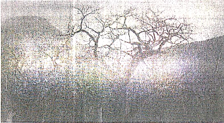 |
(a) By giving two reasons, identify the type of photograph
(b) With evidences, suggest two climates of the area
(c) Name the feature found at the background of the photograph.
(d) Give one reason, why the major trees shown in the photograph have no leaves?
(e) Why the images of trees at the fore ground seems to be large than those trees at the back ground even if are of the same size?
SECTION C (30 Marks)
Answer two (2) questions from this section.
8. Development of transport and communication system takes place fast where there is enough capital. But lack of capital leads to poor and slow development of transport and communication. Therefore the government should invest more capital to constructing good infrastructure because of the major importance that are found within this sector. Give six importance of transport and communication to any nation.
9. With examples describe cultural beliefs which influence high fertility or birthrate in developing countries lake Tanzania as your reference (provide six (6) points).
10. "Manufacturing industry plays a great role to the economic development of a country?' clarify any six (6) constrains which face the development of textile industry in Tanzania.
FORM FOUR GEOGRAPHY EXAM SERIES 26
FORM FOUR GEOGRAPHY EXAM SERIES 26
PRESIDENT’S OFFICE REGIONAL ADMINISTRATION AND LOCAL GOVERNMENT
FORM IV MOCK EXAMINATION 2020 DODOMA REGION
013 GEOGRAPHY
(For Both School and Private Candidates)
Time: 3:00 Hours Wednesday 5th August 2020 p.m.
Instructions
- This paper consists of sections A, B and C, with total of ten (10) questions
- Answer ALL questions in section A and B and two (2) questions from section C
- Map extract of (265/2) Ilonga Sheet is provided
- Credit will be given for the use of recreant diagrams
- Write your examination number on each answer sheet you have used.
SECTION A (15 Marks)
Answer all questions in this section
1. For each of the items (i) – (x), choose the correct answer from among the given alternatives and write its letter besides the item number in the answer booklet provided.
(i) What is a proper name for the study of the description of the earth?
- solar system
- Astronomy
- Geography
- Environment
- Metrology
(ii) You have been visited the coastal area of Bagamoyo and you find the forests with deep roots and roots project above the mud and water to absorb oxygen, what kind of forest is that?
- Tropical forest
- Mangrove forest
- Coniferous forest
- Deciduous forest
- Temperate forest
(iii) If the time at town X is 150E is 12:00 noon what could be the longitude town Y if it is 8:00 am?
- 150E
- 300W
- 300E
- 450W
- 450E
(iv) Mrs Kilua was wondering how fragments are worn out during collision against each other at Kondoa river during rainy season, her daughter tells her that process is known as ……
- Hydraulic action
- Attrition
- Abrasion
- Corrosion
- Hydrolysis
(v) The Maasai around Oldonyo Lengai mountain were wondering the way mountain vomiting fire and smoke, they believe that the mountain was possessed by bad evils, tell them is not evils but is …………..
- Volcanic eruptions
- Tectonic movements
- Mass wasting
- Fire from God
- Faulting
(vi) Suppose you want to carry out a field study on the atmospheric conditions suitable for growth of maize on a farm village. What are the best weather components to be considered…?
- Rainfall and wind
- Rainfall and could cover
- Moisture and sunshine
- Rainfall and temperature
- Pressure and humidity
(vii) Last year people of Bukoba District experience shaking of crustal rocks which lead to destruction of properties and death of people. Where this shaking does originated inside the earth’s crust?
- At the focus
- At the epicentre
- At the fault
- At the Lake Victoria
(viii) The process of peeling off and falling of rock mass is called
- Disintegration
- Weathering
- Mass wasting
- Erosion
- Exfoliation
(ix) Workers who were working at Government offices in Dar es salaam are now moving to Dodoma as their new offices. Identify the type of that movement
- Migrants
- Emigrants
- Emigration
- Immigration
- Immigrants
(x) Recently in Rwanda the land with their vegetation was sliding down a slope and people were busy in taking photos and wondering to that situation, tell them what type of geological process was taking place
- Erosion and deposition
- Denudation and transportation
- Land slide and erosion
- Mass wasting and transportation
- Landslide and deposition
2. Match the letter of the correct response beside the item number in the answer sheet provided.
| LIST A | LIST B |
|
|
SECTION B (55 Marks)
Answer all questions from this section
3 Study the map extract of Ilonga (sheet 265/2) and answer the following questions.
 |
- Measure the distance covered by the river in kilometre from grid reference 630000 to 600979
- Use the square methods to calculate the area covered by Namihondo pond.
- With evidence, mention three (3) economic activities which may be conducted on a mapped area
- Describe the nature of relief of the area
- With one reason, suggest the type of climate
- Identify any three (3) factors which have influenced the population distribution of Ilonga town.
4. Carefully study the data below which shows the exports of tea from Kilimanjaro in tones.
|
YEAR | TEA PRODUCTION (In Tonnes) |
| 1981 | 7,000 |
| 1982 | 3,000 |
| 1983 | 10,000 |
| 1984 | 5,000 |
| 1985 | 2,000 |
| 1986 | 12,000 |
| 1987 | 16,000 |
| 1988 | 6,000 |
| 1989 | 15,000 |
| 1990 | 3,500 |
- Name the two simplest methods of presenting the data
- Outline two values of presenting the data by simple methods mentioned in (a) above
- Present the given statistical data by using divergent bar graph.
5 (a) Mary is a good cartographer; she intends to produce a contoured map of Morogoro. What type of survey method would you advise her to apply?
(b) Apart from producing contour maps, what is the other significance of the survey you have mentioned in (a) above
(c) Mention and explain uses of any three instruments which are used in method you mentioned in (a) above
6. (i) what is a research data?
(ii) Research is a backbone for any institution, elaborate this statement by five points.
(iii) Mention three differences between interview and questionnaire.
7. Study carefully the photograph below then answers the questions that follow: -
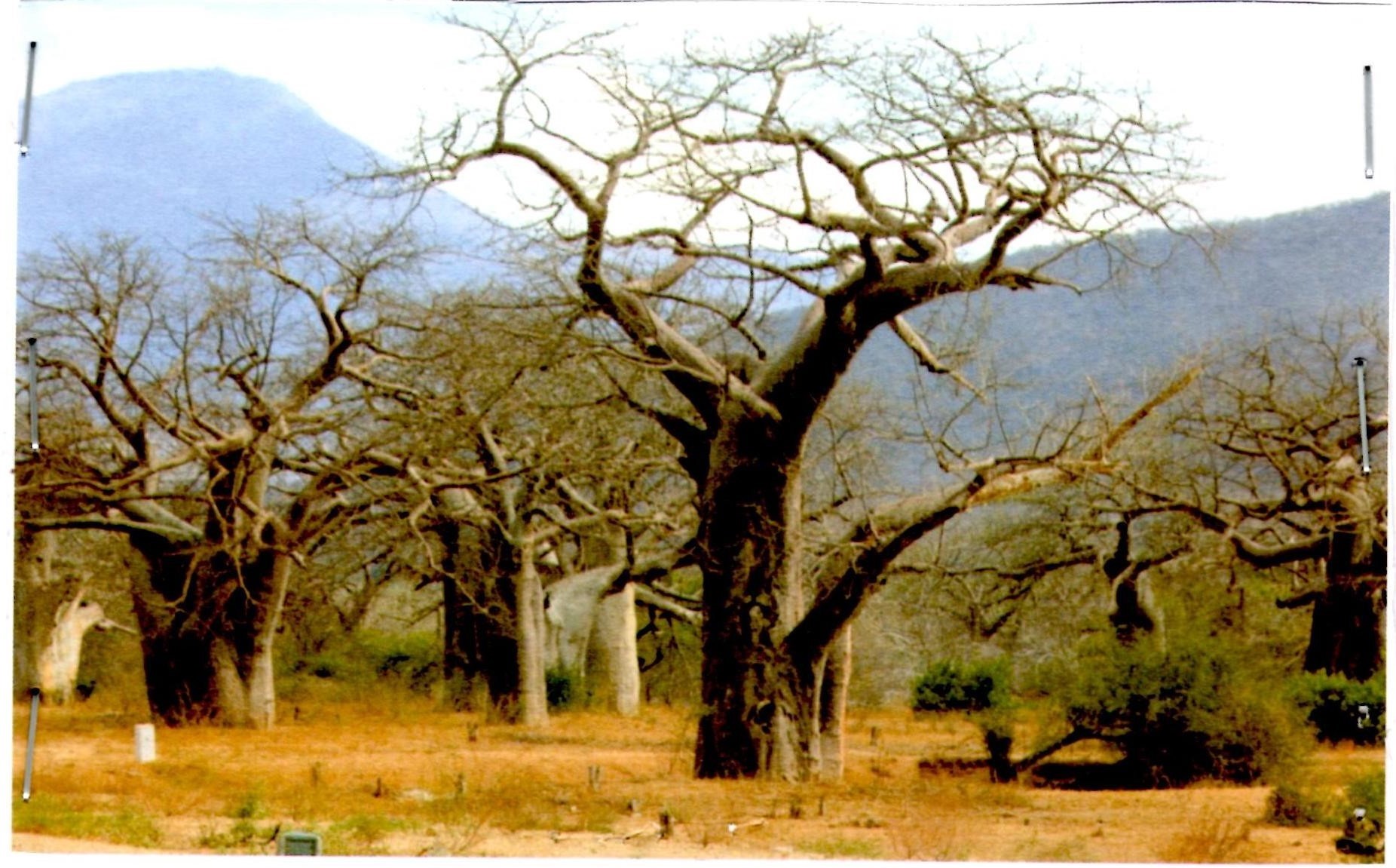
- Name the type of photograph
- Describe the possible climate of the area
- Suggest four economic activities that might be taking place in the area
- Suggest three possible regions in Tanzania where the photograph might have been taken
SECTION C. (30 Marks)
Answer two (2) questions from this section.
8. Explain any six objectives of constructing the Stigler’s gorge hydro- electric power in Tanzania.
9. Mage’s grandmother used to cultivate many crops in small area, using local seeds and hand hoe and now she is blaming that she harvests nothing in five years and she is complaining that her neighbours are the one who cause this problem. Explain to her six ways on how she can improve her farming system instead of complaining to her neighbours.
10. Explain six human factors which influences population distribution and density in Tanzania
FORM FOUR GEOGRAPHY EXAM SERIES 7
FORM FOUR GEOGRAPHY EXAM SERIES 7

DOWNLOAD LEARNING HUB APP NOW

SORRY, YOU CAN'T VIEW THIS MARKING SCHEME PLEASE DOWNLOAD LEARNING HUB APP FROM PLAYSTORE TO GET FULL ACCESS TO ALL MARKING SCHEME!!
Click Here To Download Learning Hub Tanzania App
SAMAHANI, HUWEZI KUFUNGUA MAJIBU YA MTIHANI, TAFADHALI PAKUA APP YA LEARNING HUB TANZANIA ILI KUWEZA KUFUNGUA MAJIBU YA MITIHANI KATIKA TOVUTI HII!!
Bofya Hapa Kupakua App Ya Learning Hub Tanzania
Hub App
 For Call,Sms&WhatsApp: 255769929722 / 255754805256
For Call,Sms&WhatsApp: 255769929722 / 255754805256  Matokeo Darasa VII 2025
Matokeo KIDATO CHA II 2024
Matokeo Darasa IV 2024
SECONDARY REGIONAL EXAMS
PRIMARY REGIONAL EXAMS
FORM VI NECTA REVIEWS
FORM IV NECTA REVIEWS
FORM II NECTA REVIEWS
STD VII NECTA REVIEWS
STD IV NECTA REVIEWS
SECONDARY EXAMS SERIES
PRIMARY EXAMS SERIES
PRIMARY SUBJECT NOTES
SECONDARY SUBJECT NOTES
SECONDARY TOPICAL EXAMS
SECONDARY TOPICAL QUESTIONS
PRIMARY TOPICAL QUESTIONS
PRACTICAL EXAMS & NOTES
SECONDARY REGIONAL EXAMS
DOWNLOAD SUBJECT NOTES
SCHEMES OF WORK (PRIMARY & SECONDARY)
LESSON PLAN
SECONDARY LOG BOOKS
PRIMARY LOG BOOKS
LITERARY WORKS / UCHAMBUZI VITABU
METHALI ZOTE ZA KISWAHILI
Vitendawili Vya Kiswahili
FORM VI RESULTS 2024
FORM FIVE SELECTION 2024
MATOKEO KIDATO CHA IV 2023
FORM ONE SELECTION 2024
FORM VI RESULTS 2023
Matokeo Darasa IV 2022
Matokeo Darasa VII 2025
Matokeo KIDATO CHA II 2024
Matokeo Darasa IV 2024
SECONDARY REGIONAL EXAMS
PRIMARY REGIONAL EXAMS
FORM VI NECTA REVIEWS
FORM IV NECTA REVIEWS
FORM II NECTA REVIEWS
STD VII NECTA REVIEWS
STD IV NECTA REVIEWS
SECONDARY EXAMS SERIES
PRIMARY EXAMS SERIES
PRIMARY SUBJECT NOTES
SECONDARY SUBJECT NOTES
SECONDARY TOPICAL EXAMS
SECONDARY TOPICAL QUESTIONS
PRIMARY TOPICAL QUESTIONS
PRACTICAL EXAMS & NOTES
SECONDARY REGIONAL EXAMS
DOWNLOAD SUBJECT NOTES
SCHEMES OF WORK (PRIMARY & SECONDARY)
LESSON PLAN
SECONDARY LOG BOOKS
PRIMARY LOG BOOKS
LITERARY WORKS / UCHAMBUZI VITABU
METHALI ZOTE ZA KISWAHILI
Vitendawili Vya Kiswahili
FORM VI RESULTS 2024
FORM FIVE SELECTION 2024
MATOKEO KIDATO CHA IV 2023
FORM ONE SELECTION 2024
FORM VI RESULTS 2023
Matokeo Darasa IV 2022


