PRESIDENT’S OFFICE, REGIONAL ADMINISTRATION AND LOCAL GOVERNMENT
SECONDARY EXAMINATION SERIES,
TERMINAL EXAMINATION-MAY
GEOGRAPHY FORM THREE.
Time: 3Hours
Instructions
- This paper consists of sections A, B, and C with a total eleven (11) questions.
- Answer all question in the sections A, B and two (2) questions from section C.
- Section A carries sixteen (16) marks, section B fifty four (54) marks and section C carries thirty (30) marks.
- All writing should be in blue or black pen, except for diagrams that must be drawn in pencil.
- Communication devices and any unauthorized materials are not allowed in the examination room.
- Write your Examination Number on every page of your answer booklet (s
SECTON A (16 MARKS)
- Choose the correct answer from among the alternative given.
i. The prediction of the state of the atmosphere can be done through both modern and traditional methods. Which among the following does not fit among the traditional methods used to predict weather.
- By looking at the position of the moon
- By hearing the voices of frogs
- By practicing female circumcision
- By hearing the voices of birds
- By experiencing the change of wind direction
ii. Form four students at Ngomanight secondary school were making the revision on the concept of land forms formed by vulcanicity. What do you think was the correct classification of volcanic landforms?
- Many parts according to Lava.
- Sills, dykes, valleys and earthquakes only
- Volcanic mountains and sills only
- Extrusive and intrusive features
- Batholiths, dykes and volcano only
v. Form two students at a certain school in Tanzania were taught that tourism can be done by observing minimum negative impact to the environment. Which type of tourism falls into this kind of practice?
- International tourism
- Domestic tourism
- Eco- tourism
- International tourism and domestic tourism
- Economic tourism
vi. During December holiday Caren and Kellyne decided to visit Azam company Limited in Dar es salaam where different products are made.They could see Mangoes being changes into juice and milk into Azam ice-cream. In what type of human activity does the Azam Company Limited activities falls?
- Primary human activities
- Tertiary human activities
- Quinary human activities
- Secondary human activities
- Quaternary human activities
(i) Which among the following layers of the atmosphere is characterized by 16 kilometers -thick at the equator and its temperature decreases with an increase in altitude?
- Troposphere
- Thermosphere
- Stratosphere
- Mesosphere
- Exosphere
(ii) Suppose you are living in urban center and you are interested in keeping livestock. What type of livestock keeping would be suitable for you?
- Nomadism
- Ranching
- Transhumance
- Pastoralism
- Sedentary
(v) Robert is living near the mountain within the time he noticed the bending of truck of trees and fences downward the slope. Identify the type of process occurred
- Land slide
- Mudflow
- Soil creep
- Rock fall
- Soil erosion
(vi) Kadege and Anna were debating on the section of a river characterized by a sharp V-shaped valley and interlocking spurs. As you are familiar with those phenomena, select the correct answer to educate them.
- The old stage
- The middle stage
- The youth stage
- The mature stage
- The young and middle stage
(iii) Manchester United team scored a goal at 5:00 pm in England (150 W). At what at Dar es Salaam (450E) the goal was scored?
- 1:00 pm
- 7:00 pm
- 9:45 pm
- 9:00 pm
- 6:30 am
(iv) Recently in Chile, the land with vegetation was sliding down a slope and people were busy taking photographs and wondering to the situation. Tell them what type of geological process was taking place
- Erosion and deposition
- Denudation and transportation
- Land slide and erosion
- Mass wasting and transportation
- Landslide and deposition
2. Match the description of desert land forms in list A with the corresponding names in list B by writing the letter of the correct response beside the item number in the answer booklet(s)
| LIST A | LIST B |
|
|
SECTION B: 54 MARKS
ANSWER ALL QUESTIONS
3.(a) Differentiate between longitudes and latitudes
(b) Give the importance of longitudes and latitudes
4. Describe the following features found on the ocean floor
- Continental shelf
- Continental islands
- Corals islands
- Ocean trench
- Abyssal hill
5. (a) Explain the relationship between weather and climate
(b) Explain four impacts of climate change on human activities
6. (a) Explain the formation of orographic rainfall
(b) List five factors affecting the climate of a place
7. (a) State and explain three types of rocks according to their mode of formation
(b) Briefly explain economic importance of rocks
8.(a) Using a diagram explain the following features;
- Ash and cider cones
- Shield volcano
- Acid lava cone
(b) Explain four importance of volcanic activities
SECTION B: 30 MARKS
Answer any two questions.
9.(a) Define mass wasting
(b) Explain the factors that affect the speed and nature of mass wasting.
10. Discuss the benefits of Rufiji Basin water Board
11. Describe four positive and four negative impacts of tourism in the world.
FORM THREE GEOGRAPHY EXAM SERIES 170
FORM THREE GEOGRAPHY EXAM SERIES 170
PRESIDENT’S OFFICE
REGIONAL ADMINISTRATION AND LOCAL GOVERNMENT
SECONDARY EXAMINATION SERIES
FORM THREE TERMINAL EXAMINATION
GEOGRAPHY
TIME:3 HRS MAY, 2023
INSTRUCTIONS
- This paper consists of section A, B, and C with a total of ten (10) questions.
- Answer all questions in section A and B and two questions from section C
- Map extract of HANANG (84/4) is provided
- Programmable calculators, cellular phones and other unauthorized materials are not allowed in the examination room.
- Write your examination number on every page of your answer booklet
SECTION A (15 marks)
- For each of the items (i-x) choose the correct answer from among the given alternatives and write its letter beside the item number in the answer booklet provided.
- Why does the sun appears larger than other stars that are seen at night?
- Star light bends as it passes planets
- The sun is closer to the earth than other stars
- The earth’s atmosphere filters out light from other stars
- Day light brightens the sun making it appear large
- The capacity of our eyes does not view far during the night
- Mike and Jose went for swimming at Ruaha River, while swimming, Jose reached a point at the center of the river where there was a round depression which is deeper than the rest parts of the river. What was this
- Plunge pole
- River capture
- Pot hole
- Meander
- Knick point
- One of the condition for the formation of delta is that, there must be …..
- Enough load deposited in the middle course
- Active erosion in the upper and middle course
- A coast characterized by heavy tides especially where the river enters the sea
- Enough load deposited in the upper and lower course
- Active erosion in the upper course
- Erosion by wind takes place through the process of …..
- Abrasion, attrition and deflation
- Abrasion, collision and blowing
- Collision, abrasion and attrition
- Deflation, blowing and dust
- Deflection and blowing wind
- The Amazon and Congo Basins are regions characterized with the same geographical background to human activities, climate , vegetation and relief. What could be the general term for those regions?
- Natural regions
- Natural resources
- Natural vegetation
- Natural landscapes
- Natural climate
- During dry seasons most plants shade their leaves as a way to reduce the amount of water release. The correct term for this process is …..
- Evaporation
- Precipitation
- Transpiration
- Condensation
- Infiltration
- Amina wants to carry out a field study on the atmospheric conditions suitable for growth of maize on a farm village. What are the best weather components to be considered
- Rainfall and wind
- Rainfall and cloud cover
- Moisture and sunshine
- Rainfall and temperature
- Pressure and humidity
- The Maasai around Oldonyo Lengai mountain were wondering the way the mountain was ejecting fire and smoke. They believed that the mountain was possessed by bad evils. Tell them what geological process that was taking place
- Volcanic eruption
- Tectonic movements
- Mass wasting
- Fire from God
- Faulting
- For a person who is storing, supplying and distributing plastic bags in Tanzania, the fine is between.
- TZs5,000,000 up to TZs 2,000,000 or up to 2 years of imprisonment or both.
- TZs 5,000,000 up to TZs 50,000,000 or up to 2 years of imprisonment or both
- TZs 20,000,000 up to TZs 1billion or up to 2 years of imprisonment or both
- TZs 100,000 up to TZs 500,000 or up to 3 months of imprisonment or both
- TZs 30,000 up to TZs 200,000 or up to 7 days of imprisonment or both
- Mr. ILIMRADI SHIBE is a peasant at Chita village in Mlimba District who applies proper methods of farming. Identify some proper methods of farming MR. ILIMRADI SHIBE uses which suit them
- Terracing, overgrazing and contour ploughing
- Contour ploughing, crop rotation and mulching
- Recycling, bush fallowing and terracing
- Terracing, overgrazing and crop rotation
- Shifting cultivation, terracing and overstocking
- Match the item in list A with the response in list B by writing the letter of the correct response in the answer sheet provided.
| LIST A | LIST B |
|
|
SECTION B (55 marks)
Answer all questions
- Carefully study the map extract of HANANG sheet provided (84/4) and then answer the questions that follows
- Name any four indicators that shows the presence of the following economic activities on the map.
- Tourism
- Agriculture
- Mining
- Calculate area of lake Barangida in km2
- A farmer was at grid reference 680160. He saw a fire in the North East 5kms.
- Find/write the grid reference position of the fire
- Find the direction from the fire to the origin point
- Name the physical obstacles which the farmer will face if he walks in strait line to the position of the fire.
- a) Name and explain how is formed the features found at grid reference 680160….,
b) What are the economic importance of the features you have mentioned in 3(iv) above at least two (02)
- With evidence from the map name two physical features as depicted on the mapped area.
4. Cash crops production in Tanzania 2013-2019.
| Years | sisal | cotton | coffee | Tea |
| 2013 | 113 | 42 | 53 | 14 |
| 2014 | 105 | 67 | 45 | 17 |
| 2015 | 92 | 50 | 53 | 17 |
| 2016 | 81 | 56 | 49 | 18 |
| 2017 | 86 | 60 | 48 | 17 |
| 2018 | 74 | 59 | 67 | 16 |
| 2019 | 10 | 12 | 11 | 13 |
(a)Name the two simplest way of presenting the data.
(b)Explain the three advantages and two disadvantages of presenting the data by simple methods mentioned in (a).
(c)Present the given data by using the compound bar graph.
5. a) Explain the meaning of chain surveying.
b) Describes five (5) principles of conducting chain surveying.
6. (a) (i) By using diagram show the three main parts of ground photographs.
(ii) Describe main distinctive features of oblique photographs.
(b) Mr. Msemakweli is a professional photographer at your school, he wanted to produce form four photo-entry form and identification cards for all form four students at your school.
(i) Identify the type of photograph that Mr. Msemakweli was likely to take.
(ii) Describe three advantages and disadvantages of the photograph named in (b) (i) above.
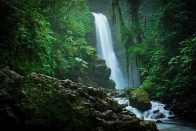
- Carefully study the following photograph and answer the questions that follows.

- What is the name of dominant trees?
- Suggest three possible regions in Tanzania what the photograph have been taken.
- Suggest climatic condition that favor such type of dominant trees.
- Name three relief features shown on the photograph
- Name two land uses that might be taking place in the area.
SECTION C (30 Marks)
Answer any two questions from this section.
- Identify any six setbacks of large-scale agriculture in Tanzania.
- Kichachani was talking with her child who believes that the temperature was affected worldwide. By using six evidences, describe how Kichachani will prove to her child that temperature can be affected by several factors
- Most of the East African Rivers are not suitable for navigation purpose. Justify this statement by six points.
FORM THREE GEOGRAPHY EXAM SERIES 126
FORM THREE GEOGRAPHY EXAM SERIES 126
THE PRESIDENT’S OFFICE
MINISTRY OF EDUCATION, REGIONAL ADMINISTRATION AND LOCAL GOVERNMENT
COMPETENCE BASED SECONDARY EXAMINATION SERIES
GEOGRAPHY TERMINAL EXAMINATION
FORM THREE-2022
INSTRUCTIONS
- This paper consists of sections A, B and C with a total of ten (10) questions.
- Answer all questions in sections A and B and any two (2) questions from section C.
- Map extract of Mkomazi (Sheet 109/1) is provided.
- Programmable calculators, cellular phones and unauthorised materials are not allowed in the examination room.
- Write your Examination Number on every page of your answer booklet(s).
SECTION A (15 Marks)
Answer all questions in this section.
1. For each of the items (i) — (x), choose the correct answer from among the given alternatives and write its letter besides the item number in the answer booklet provided.
(i)If Ronaldo scores a goal for his team playing in Colombo (80°E) at 4:00pm local time, what will be the best time at Mtwara (45°E) Tanzania?
- 1:40pm
- 1:40am
- 1:20pm
- 1:20am
- 6:20am
(ii)The intensity of an earthquake is measured by an instrument called
- Epicenter
- Chronometer
- Seismography
- Ritcher scale
- Hygrometer
(iii)Michewen at sea level has a temperature of 32°C. What is the temperature at Karatu 1500m above sea level?
- 19°C
- 9°C
- 0.6°C
- 17°C
- 23°C
(iv)Which of the following feature is formed by wind erosion?
- Delta
- Lagoon
- Rock Pedestal
- Barchan
- Seif dune
(v)Which of the following has a limestone surface feature?
- Stalagmite
- Underground stream
- Tombolo
- Polje
- Loess
(vi)The sun is overhead at the equator every year on
- 21st June
- 21st March
- 24th March
- 22nd December
- 25th December
(vii)A type of river erosion which increases the length of the river channel is called.
- Headward erosion
- Vertical erosion
- Lateral erosion
- Sheet erosion
- Deep erosion
(viii)Most building materials in Tanzania originated in which type of rock?
- Metamorphic rock
- Sedimentary rock
- Igneous rock
- Plutonic rock
- Conglomerates rock
(ix)Exfoliation is the type of weathering which mostly occurs:
- At higher altitudes
- In chalk and limestone area
- In arid and semi-arid areas
- In humid climates
- In arid and equatorial regions
(x)Why do two different countries located in different latitudes or hemispheres experience a similar type of natural vegetation? It is because of
- Their position which are very far
- Similar traditions of the people living in those areas
- The same type of climate
- Same onshore prevailing wind
- Fertile soil, good cloud cover and rains
2. Match the descriptions of vulcanism in Column A with the corresponding items in Column B by writing the letter of the corresponding answer beside the item number in the answer booklet provided.
| COLUMN A | COLUMN B |
|
|
3. With the aid of a well labelled diagram, describe the underground karts region features.
4.Carefully study the table below which show the use of soft drinks in creates at Chapamaji village then answer the questions that follows
| Types of Soft drink | Coca Cola | Fanta | Pepsi | Mirinda | Novida |
| Number of Crates | 300 | 150 | 250 | 100 | 200 |
- Draw a pie chart to present the data above
- Give three (3) merits and three (3) demerits of the method used above
5. Mr Kazimoto as a chairman of Bajado village conducted a simple chain survey in order to get right measurement of the village farm.
- Show three (3) merits and three (3) demerits of simple chain survey
- Describe five (5) instruments used in surveying the farm.
6.Carefully study the weather data for a station in Australia and answer the questions that follow
| Month | J | F | M | A | M | J | J | A | S | O | N | D |
| Temp(°C) | 28.3 | 27.5 | 28.5 | 29 | 26.7 | 26 | 26 | 25 | 24 | 26 | 27 | 28 |
| Rainfall (mm) | 380 | 330 | 240 | 175 | 170 | 5 | 2.5 | 2.2 | 17 | 50 | 210 | 230 |
- Calculate the annual mean temperature for the station
- Determine the rainfall range
- Find the temperature mode and median
- Comment on the relationship between temperature and rainfall for the station
- Giving two examples, show the application of data in the daily life.
7. Carefully study the photograph below and answer the questions that follow
- With two (2) reasons suggest on the types of climates
- Name the type of photograph shown above
- Describe two (2) main physical features found on the photograph
- Examine four (4) economic importance of the features shown on the photograph
SECTION C (30 marks)
Answer two (2) questions from this section
8.Explain six (6) problems facing peasantry agriculture in Tanzania
9.Explain six (6) limitations and six adverse effects of mining industry in African countries
10. It is known that; the earth rotates on its axis while revolving around the sun. Describe the significance of the Earth’s revolution. (Four (4) points)
FORM THREE GEOGRAPHY EXAM SERIES 86
FORM THREE GEOGRAPHY EXAM SERIES 86
THE PRESIDENT’S OFFICE
MINISTRY OF EDUCATION, REGIONAL ADMINISTRATION AND LOCAL GOVERNMENT
SECONDARY EXAMINATION SERIES
GEOGRAPHYTERMINALEXAMINATION
FORM THREE-2021
Time: 3Hours
Instructions.
- This paper consists of section A, B and C with a total of 10 questions
- Answer all questions in section A and B and two questions from section C.
- Section A carries 15 marks, section B 55 marks and section C 30 MARKS
- Map extract sheet for Hanang (Sheet 84/4) is provided.
- Programmable calculators, cellular phones and any other unauthorized materials are not allowed in examination room.
- Write your number on every page of your answer booklet.
SECTION A (15 Marks)
Answer All questions in this section.
1. For each of the items (i) — (x), choose the correct answer from among the given alternatives and write its letter besides the item number in the answer booklet provided.
- The tourists enjoyed the temperature of Zanzibar which was at sea level. They also planned to travel from Zanzibar to Manyara which is 1500m above sea level. What will be the temperature experienced by the tourists in Manyara?
- 230C
- 90C
- 190C
- 0.60C
- 170C
- Which of the following occurs when the moon's shadow cast over the earth?
- Solar eclipse
- Lunar eclipse
- Aphelion
- Summer solstice
- Equinoxes
- Which of the following layers of the earths interior is made up of sima and sial?
- Biosphere
- Hydrosphere
- Asthenosphere
- Lithosphere
- Barysphere
- Mitomingi was wondering the way large amount of soil and rock materials were sliding downward towards the steep slope. What geological processes were occurring in that area?
- Weathering and erosion
- Deposition and transportation
- Weathering and denudation
- Mass wasting and transportation
- Erosion and transportation
- You are asked to help a Form Two student who failed to identify the types of forests found in the area with low temperatures. What type of forest will you suggest among the following?
- Tropical rain forest
- Coniferous forest
- Equatorial forest
- Deciduous forest
- Mediterranean forest
- What is the social-economic advantage of reserved forests to societies?
- Tourism
- Lumbering
- Mining
- Forestry
- Agriculture

- After learning different types of soil texture, students were asked to identify the best type of soil which can be mixed with cement for building a house. What type of soil will be picked by the students who understood the lesson?
- Sandy
- Silt
- Alkaline soil
- Loam
- Clay
- Which among the following is a heavenly body that possesses and transmits its own light?
- Moon
- Sun
- Earth
- Astreroid
- Planet.
- A region which consists of thick forests, tree dwellers and people who engage in cultivation of rubber, cocoa, bananas and oil palms is known as
- Tropical savanna
- Tropical monsoon
- Polar climate
- Mediterranean
- Equatorial.
- Which among the following features are produced by wave erosion?
- Geo, wave cut platform and stack
- Blow hole, sea arch and levee
- Sea arch, beach and stump
- Beach, spit and bars.
- Tombolo, meander and cliff.
2.Match the items in list A with the correct description in list B and write the answer in the space provided.
| LIST A | LIST B |
|
|
SECTION B (55 Marks)
Answer all questions in this section.
3. Carefully study the map extract of Hanang (Sheet 84/4) provided and answer the following questions:
(a) Express the map scale as a statement.
(b) Find the bearing of grid reference 720220 to 680180.
(c) Giving three evidences from the map, suggest the climate of the mapped area.
(d) Suggest with evidence, five major economic activities which might take place in the area.
(e) Give four supportive contents of a topographical map provided.
(f) Mention three factors which affected the contents of the map given.
4. Study the following data showing the production of Irish Potatoes in a thousand (“000”) tones in three villages in Tanzania from 2000 to 2002, then answer the questions that follow:
|
|
Potato production (“000”) | ||
| Sunga | Mwaligulu | Mpera | |
| 2000 | 20 | 15 | 5 |
| 2001 | 40 | 15 | 10 |
| 2002 | 50 | 20 | 10 |
(a) Construct a compound bar graph to show the production of Irish potatoes in the three villages.
(b) Give three advantages and two disadvantages of the compound bar graph.
(c) Suggest any other methods which could be used to present the data provided in the table.
5. (a) (i) Define chain survey.
(ii) Give four principles of chain survey.
(b) Give one reason for each of the following:
(i) Ranging pole has a pointed metal end.
(ii) Note book is important during field study.
(iii) Back bearings are taken during compass survey.
(iv) During surveying, measurements are called back by the booker.
6.Study the following photograph and answer the questions that follow:
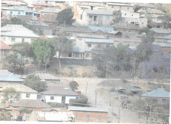
- Giving two reasons, name the type of photograph.
- Suggest the type of settlement pattern and give one factor that has influenced it.
- Suggest two economic activities that might be taking place in the area.
- Provide three advantages of photographs over maps.
7. (a) What is an earthquake?
(b) Briefly explain five effects of earthquakes.
(c) Describe four ways of reducing the risks of earthquakes.
SECTION C (30 Marks)
Answer two (2) questions from this section.
8. Elaborate eight reasons indicating why the transportation sector is important to the economy of Tanzania.
9. By using concrete examples, explain five negative effects of tourism in East Africa.
10. Examine the best ways which can ensure a sustainable use of forestry resources.
FORM THREE GEOGRAPHY EXAM SERIES 53
FORM THREE GEOGRAPHY EXAM SERIES 53
THE PRESIDENT’S OFFICE MINISTRY OF EDUCATION, LOCAL ADMINISTRATION AND LOCAL GOVERNMENT
GEOGRAPHY- TERMINAL EXAMINATION-MAY
FORM THREE
TIME: 3:00HRS 2020
NAME:_______________________________________________ CLASS:___________
INSTRUCTIONS
- This paper consists of sections A,B,C and D
- Answer All questions in section A,B and C and ONE (1) question from each part in section D
- Map extract of ENGARUKA BASIN sheet 54/1 is provided
- Credits will be awarded for the use of relevant diagrams and examples
- All writings must be done in BLUE or Black ink except for the diagrams which must be done by pencil
- Remember to write your name and class in the spaces provided above.
SECTION A (25 MARKS)
1. For each of the items (i-x), choose the correct answer among the given alternatives and write its letter beside the item number in the box provided.
(i) Great circle refers to:-
- A line of longitude
- Greenwich meridian only
- A line of the globe
- The shortest distance between the two points
- A circle in the surface whose plane passes through the centre of the globe.
(ii) Pangani at sea level has a temperature of 32C, what is the temperature of Arusha 1500M above the sea level?
- 230c
- 170c
- 90c
- 190c
- 0.60c
(iii) Plants with long roots, thorny stems, needle shaped leaves, wax or hair are found in:-
- The monsoon region
- Tropical grasslands
- Hot deserts
- The Mediterranean region
- The equatorial region
(iv) The slow movement of soil particles which can be recognized by bending of trees and fences is referred to as:-
- Soil erosion
- Mud flow
- Land slide
- Rock fall
- Soil creep
(v) The secretary general of the U.N addressed the world from New York (75w 42N) at 7:30p.m Tuesday. At what time and day will the people in Dar es Salaam (45E 06S) hear the same speech?
- 3:30p.m Wednesday
- 12:30p.m Tuesday
- 3:30a.m Wednesday
- 8:30p.m Tuesday
- 11:30p.m Wednesday
(vi) The barysphere of the earth is made up of:
- Silica and magnesia
- Iron and aluminia
- Silica and aluminia
- Iron and nickel
- Iron and Zinc
(vii) The name given to the boundary that demarcates solid materials from the molten mantle is:
- Mohorovicic
- Mesosphere
- Core
- Astheriosphere
- Gutenberg
(viii) _____________is a point where cold air from the polar regions meet warmer air from lower latitudes
- Pressure gradient
- Humidity
- Tropical maritime
- Polar front
- Cyclone
(ix) Which one of the following combinations form chemical weathering?
- Organic acid and temperature change
- Exfoliation and carbonation
- Organic acid and weak carbonic acid
- Mud flow and land slides
- Temperature change and frost action
(x) The earth is said to be oblate spherical because it is:
- A flattened sphere
- Spherical in shape
- Has a flattened surface
- Round
- A planet
2. Match the items in list A with the response in list B by writing the letter of the correct response beside the item number.
| LIST A | LIST B |
| (i) The earth’s zone which is made up of nickel and iron (ii) Magma which reaches the earth’s surface and solidifies to form extrusive features (iii) A sheet of magma which lies along the bedding plane (iv) A wall like feature formed when a mass of magma cuts across the bedding plane (v) The uppermost layer of the earth |
|
SECTION B (27 MARKS)
3. a) What do you understand by “Earthquake”?
b) Briefly explain five effects of earthquakes
c) Describe four ways of reducing the risks of earthquakes
4. (a) What is data in statistics?
(b) Explain with examples the following terms
- Individual data
- Discrete data
- Continuous data
- Grouped data
5. There are a number of researches conducted from different areas across the world. Suggest four advantages of research findings to Tanzania as a developing country after giving the definition of the word research”
6. a) Define surveying.
b) When someone wants to conduct a survey he/she has to prepare himself/herself before. Explain four (4) important things a surveyor has to prepare before deciding to conduct a chain survey.
7. Study carefully the map extract of ENGARUKA BASIN sheet 54/1 and then answer the questions that follow:
- Calculate the area covered by seasonal swamp in square kilometer (km2)
- With evidence from the map suggest two economic activities which might take place in the mapped area
- Name the features found at the following grid reference 875658 and 840580
- Describe the relief features found in a mapped area
- Change the map scale into statement scale
8. Study carefully the photograph provided below then answer the questions that follow:
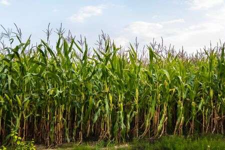
- With reasons suggest the type of photograph above
- Name the crop shown in the photograph
- Mention the natural conditions which favor the growth of the crop above
- Tanzania is very famous in growing the crop mentioned (b) above. Name three regions of Tanzania which grow the crop at commercial level
- With concrete evidence, explain the scale of production as shown on the photograph
SECTION C 30 MARKS
9. Explain the factors that influence the exploitation of mineral resources.
10. With vivid examples explain the factors which contribute to the drastic movement of people from rural to urban areas.
11. How does rapid population explosion affect small scale agriculture?
FORM THREE GEOGRAPHY EXAM SERIES 17
FORM THREE GEOGRAPHY EXAM SERIES 17

DOWNLOAD LEARNING HUB APP NOW

SORRY, YOU CAN'T VIEW THIS MARKING SCHEME PLEASE DOWNLOAD LEARNING HUB APP FROM PLAYSTORE TO GET FULL ACCESS TO ALL MARKING SCHEME!!
Click Here To Download Learning Hub Tanzania App
SAMAHANI, HUWEZI KUFUNGUA MAJIBU YA MTIHANI, TAFADHALI PAKUA APP YA LEARNING HUB TANZANIA ILI KUWEZA KUFUNGUA MAJIBU YA MITIHANI KATIKA TOVUTI HII!!
Bofya Hapa Kupakua App Ya Learning Hub Tanzania
Hub App
 For Call,Sms&WhatsApp: 255769929722 / 255754805256
For Call,Sms&WhatsApp: 255769929722 / 255754805256  Matokeo Darasa VII 2025
Matokeo KIDATO CHA II 2024
Matokeo Darasa IV 2024
SECONDARY REGIONAL EXAMS
PRIMARY REGIONAL EXAMS
FORM VI NECTA REVIEWS
FORM IV NECTA REVIEWS
FORM II NECTA REVIEWS
STD VII NECTA REVIEWS
STD IV NECTA REVIEWS
SECONDARY EXAMS SERIES
PRIMARY EXAMS SERIES
PRIMARY SUBJECT NOTES
SECONDARY SUBJECT NOTES
SECONDARY TOPICAL EXAMS
SECONDARY TOPICAL QUESTIONS
PRIMARY TOPICAL QUESTIONS
PRACTICAL EXAMS & NOTES
SECONDARY REGIONAL EXAMS
DOWNLOAD SUBJECT NOTES
SCHEMES OF WORK (PRIMARY & SECONDARY)
LESSON PLAN
SECONDARY LOG BOOKS
PRIMARY LOG BOOKS
LITERARY WORKS / UCHAMBUZI VITABU
METHALI ZOTE ZA KISWAHILI
Vitendawili Vya Kiswahili
FORM VI RESULTS 2024
FORM FIVE SELECTION 2024
MATOKEO KIDATO CHA IV 2023
FORM ONE SELECTION 2024
FORM VI RESULTS 2023
Matokeo Darasa IV 2022
Matokeo Darasa VII 2025
Matokeo KIDATO CHA II 2024
Matokeo Darasa IV 2024
SECONDARY REGIONAL EXAMS
PRIMARY REGIONAL EXAMS
FORM VI NECTA REVIEWS
FORM IV NECTA REVIEWS
FORM II NECTA REVIEWS
STD VII NECTA REVIEWS
STD IV NECTA REVIEWS
SECONDARY EXAMS SERIES
PRIMARY EXAMS SERIES
PRIMARY SUBJECT NOTES
SECONDARY SUBJECT NOTES
SECONDARY TOPICAL EXAMS
SECONDARY TOPICAL QUESTIONS
PRIMARY TOPICAL QUESTIONS
PRACTICAL EXAMS & NOTES
SECONDARY REGIONAL EXAMS
DOWNLOAD SUBJECT NOTES
SCHEMES OF WORK (PRIMARY & SECONDARY)
LESSON PLAN
SECONDARY LOG BOOKS
PRIMARY LOG BOOKS
LITERARY WORKS / UCHAMBUZI VITABU
METHALI ZOTE ZA KISWAHILI
Vitendawili Vya Kiswahili
FORM VI RESULTS 2024
FORM FIVE SELECTION 2024
MATOKEO KIDATO CHA IV 2023
FORM ONE SELECTION 2024
FORM VI RESULTS 2023
Matokeo Darasa IV 2022


