Student index number.......................................................
PRESIDENTS OFFICE
REGIONAL ADMINSTRATION AND LOCAL GOVERNMENT
SECONDARY EXAM SERIES
FORM TWO PRE MOCK EXAMINATION
GEOGRAPHY
CODE 013
TIME: 2:30 HRS. APRIL 2025
Instructions
1. This paper consists of sections A, B and C with a total of ten (10) questions.
2. Answer ALL questions.
3. Section A and C carry fifteen (15) marks each and section B carries seventy
(70) marks.
4. All writings must be in blue or black ink and should be written in the space
provided.
5. Cellular phones, calculators and any unauthorized materials are not allowed in the examination room,
6. Write your examination number at the top right corner of every page.
SECTION A: (15 Marks)
Answer All questions in this section
1. For each of the items (i) – (x), choose the correct answer from among the given alternatives and write its letter in the box provided below.
(i) Miss Asha is a small animal keeper at the village, she has two cows and she normally uses a rope to tie them to the post at one end of the rope and the other side being tied to the cow’s leg. Which process is this?
A. Zero grazing
B. Transhumance
C. Tethering
D. Nomadism
E. Sedentary
(ii) Jesca was swimming at deep sea on the way she met a long, narrow, steep sided elongation plunging from the deep-sea plain. What is the common name of the feature?
A. oceanic ridge
B. Continental shelf
C. Ocean
D. Deep Sea plain
E. Ocean floods
(iii) Suppose you want to carry out a field study on the atmospheric conditions suitable for growth of banana on village farm. What are the best weather components to be considered?
A. Rainfall and wind
B. Rainfall and cloud cover
C. Moisture and sunshine
D. Rainfall and temperature
E. Pressure and humidity
(iv) The Tourists enjoyed the temperature of Kilwa which was 32°C at sea level. They also planned to travel from Kilwa to Mwanza which is 1500M above sea level. What will be the temperature experienced by tourists in Mwanza?
A. 9°C
B. 19°C
C. 23°C
D. 0.6°C
E. 29°C
(v) A form of human activities which involves extraction of resources from the natural environment is
A. Primary activities
B. Secondary activities
C. Quaternary activities
D. Quinary activities
E. Tertiary activities
(vi) Which type of mountain is formed by prolonged denudation?
A. Block mountains
B. Residual mountains
C. Volcanic mountains
D. Fold mountains
E. Extinct volcanic mountain
(vii) Which of the following cannot be used effectively to locate a place on a map?
A. Place names
B. Altitude
C. Grid reference
D. Bearing and direction
E. Longitude and Latitude
viii) A farmer planted maize, cassava, watermelon and beans on the same farm. This process is called.
A. Bush fallowing
B. Shifting cultivation
C. Mixed farming
D. Manufacture
E. Intercropping
(ix) The environmentalist emphasizes the people on the use of solar energy as the source of energy in their daily activities due to the fact that solar energy is:
A. Non-renewable energy
B. Non energy
C. Renewable energy
D. Available energy
E. Environmentally friendly energy
(x) Form Two students from Njombe Girls Secondary School visited different historical sites found in Bagamoyo. Identify the type of tourism they were involved in:
A. Cultural tourism
B. International tourism
C. Eco-tourism
D. Domestic tourism
E. Artificial tourism
2. Match the description of Geographical term in LIST A with the corresponding correct item in LIST B by writing a correct response below in term of number provided
| LIST A | LIST B |
|
|
SECTION B (70 Marks)
Answer all questions in this section
`
3. Form one students from Kiwanjani Boys Secondary School visited the weather station at Kilimanjaro region; they saw various instruments and devices. One device was white wooden box, a box had louvers all the sides and double boarded roof. If mounted on a stand 121 cm above the ground, it was the first time for form one students to see that device.
a) As a form two student, identify the name of that device
________________________________________________________
b) Why do you think the device was having the following characteristics
i. Paint white
__________________________________________________
ii. Had louvers to all sides
__________________________________________________
c) Name the two (2) major instruments kept in it
(i) ___________________________________________________
(ii) ___________________________________________________
d) Mention the uses of instruments mentioned above.
(i) ___________________________________________________
(ii) ___________________________________________________
e) List one (1) importance of that station in our daily life
(i) ___________________________________________________
4. A resource is anything that can be utilized if necessary. Ambwene is a fisherman who uses to catch fishes from Lake Victoria for food and Commercial purposes.
(a) Identify the type of activity mentioned above
__________________________________________________________________
(b) Explain any four characteristics of small-scale crop cultivation
(i)…………………………………………………………………………………….
(ii)……………………………………………………………………………………
(iii)…………………………………………………………………………………..
(iv)…………………………………………………………………………………..
5. (a) Outline five importance of human economic activities
(i) …………………………………………………………………………………
(ii)…………………………………………………………………………………
(iii)………………………………………………………………………………….
(iv)………………………………………………………………………………….
(v)………………………………………………………………………………….
(b) Mention the three environmental problems associated with human activities
i) ____________________________________________________________
ii) ____________________________________________________________
iii) ____________________________________________________________
(c) Water is useful in the growth of any country’s economy. Mention two
product obtained from water.
(i)…………………………………………………………………………………
(ii)………………………………………………………………………………..
6. Maasai in Tanzania are famous in livestock keeping. They normally keep their animals by moving from one place to another with their herds in searching of water and pastures.
a) What is the system of livestock keeping they practice?
_________________________________________________________
b) Outline the three environmental advantages transhumance
(i)…………………………………………………………………………
……………………………………………………………………………
(ii)………………………………………………………………………
……………………………………………………………………………
(iii)………………………………………………………………………..
……………………………………………………………………………
c) Apart from Maasai suggest other two (2) societies in East Africa practicing
such system.
i. ______________________________________________________
ii. ______________________________________________________
d) List the three benefits of the livestock keeping identified in (a) above
i. ______________________________________________________
ii. ______________________________________________________
iii. ______________________________________________________
7. (a) Despite the highnumberof touristsin Tanzanians, we are still facing with problems
mention five (5) problems of tourism
(i)……………………………………………………………………….
(ii)………………………………………………………………………
(iii)………………………………………………………………………
(iv)………………………………………………………………………
(v)………………………………………………………………………..
8. The meteorological data obtained in sea meteorological center was as follows
| MONTH | J | F | M | A | M | J | J | A | S | O | N | D |
| TEMPERATURE (°C) | 13 | 16 | 20 | 25 | 28 | 35 | 36 | 35 | 32 | 26 | 19 | 14 |
| RAINFALL (mm) | 2.5 | 2.5 | 0 | 0 | 0 | 0 | 0 | 2.5 | 0 | 0 | 2.5 | 15 |
(i) Calculate the mean annual temperature for the station
(ii) Calculate the total annual rainfall for the station
(iii) give the annual range of temperature for the station
(iv) suggest the type of the climate.
(v) Outline the two crops which can be grown on the place
(a) ……………………………………………..
(b) ………………………………………………
9. Study careful the Map of MALAGARASI and then answer the following questions:
MALAGARASI SCALE 1:50,000
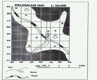
(i) Write grid references of the following points.
A…………………………………………………….
B……………………………………………………
C. ……………………………………………………
E……………………………………………………..
G…………………………………………………..
(ii) (a) Find the area of Kivu swamp in square kilometers
(iii) Express the given scale into Statement
(iv) Mention three (3) human activities found on the map.
(a) ……………………………………………………
(b)…………………………………………………….
(c) …………………………………………………..
SECTION C (15 Marks)
10. Analyze six problems facing small scale Agriculture in Tanzania
……………………………………………………………………………………………………………………………………………………………………………………………………………………………………………………………………………………………………………………………………
……………………………………………………………………………………………………………………………………………………………………………………………………………………………………………………………………………………………………………………………………
……………………………………………………………………………………………………………………………………………………………………………………………………………………………………………………………………………………………………………………………………
……………………………………………………………………………………………………………………………………………………………………………………………………………………………………………………………………………………………………………………………………
……………………………………………………………………………………………………………………………………………………………………………………………………………………………………………………………………………………………………………………………………
……………………………………………………………………………………………………………………………………………………………………………………………………………………………………………………………………………………………………………………………………
……………………………………………………………………………………………………………………………………………………………………………………………………………………………………………………………………………………………………………………………………
……………………………………………………………………………………………………………………………………………………………………………………………………………………………………………………………………………………………………………………………………
……………………………………………………………………………………………………………………………………………………………………………………………………………………………………………………………………………………………………………………………………
……………………………………………………………………………………………………………………………………………………………………………………………………………………………………………………………………………………………………………………………………
……………………………………………………………………………………………………………………………………………………………………………………………………………………………………………………………………………………………………………………………………
……………………………………………………………………………………………………………………………………………………………………………………………………………………………………………………………………………………………………………………………………
……………………………………………………………………………………………………………………………………………………………………………………………………………………………………………………………………………………………………………………………………
……………………………………………………………………………………………………………………………………………………………………………………………………………………………………………………………………………………………………………………………………
……………………………………………………………………………………………………………………………………………………………………………………………………………………………………………………………………………………………………………………………………
Page 1 of 10
FORM TWO GEOGRAPHY EXAM SERIES 204
FORM TWO GEOGRAPHY EXAM SERIES 204
THE PRESIDENT’S OFFICE
REGIONAL ADMINISTRATION AND LOCAL GOVERNMENT
GEOGRAPHY FORM TWO PRE- MOCK EXAMINATION
CODE 012
TIME: 2:30 HOURS
INSTRUCTIONS.
- This paper consists of section A, B and C with the total number of ten(10) questions
- Answer all questions in each section
- Section A carries (15) marks, section B (70) marks and section C carries (15) marks
- All writing must be in blue/black ink except drawing which must be in pencil
- Cellular phones and any unauthorized materials are not allowed in the assessment room.
SECTION A (15 Marks)
Answer all questions in this section
1. For each of the items (i) – (x) choose the correct answer from among the given alternatives and write its letter beside the item number in the answer sheet provided
(i) Geography is the study of:
- Animals and their habitats.
- Human societies in isolation.
- The Earth's surface and its relationship with humans.
- Only the physical features of the Earth.
(ii)The Earth's layers, starting from the innermost, are:
- Crust, mantle, core.
- Atmosphere, hydrosphere, lithosphere.
- Inner core, outer core, mantle.
- Troposphere, stratosphere, mesosphere.
(ii)The sun is classified as a:
- Gas giant planet.
- Dwarf planet.
- Star.
- Asteroid.
(iv) The way humans use and modify the land is called:
- Weather patterns.
- Landforms.
- Human geography.
- Climate change.
(v)The short-term condition of the atmosphere at a specific time and place is called:
- Climate.
- Weather.
- Air pressure.
- Humidity.
(vi)The average weather condition over a long period in a specific region is called:
- Weather.
- Climate.
- Precipitation.
- Temperature.
(vii)Lines of latitude run:
- East to West.
- North to South.
- Diagonally across the globe.
- They don't exist on maps.
(viii)Lines of longitude run:
- East to West.
- North to South.
- Diagonally across the globe.
- They don't exist on maps.
(ix)Deforestation can contribute to all of the following EXCEPT:
- Soil erosion.
- Increased flooding.
- Reduced biodiversity.
- Higher carbon dioxide levels in the atmosphere.
(x) Sustainable development aims to meet current needs without:
- Improving technology.
- Harming the environment.
- Increasing economic growth.
- Reducing social inequality.
2. Match the weather element with the corresponding instrument used for measurement.
| Column A | Column B |
|
|
SECTION B: 70 Marks
3. (a) Define the following terms
- Geography
- Environment
(b) Name two branches of geography.
(c) A part from planets, name two other heavenly bodies.
4. (a) What is longitude?
(b) The diagram below shows the structure of the earth. Use it to answer questions i. and ii.
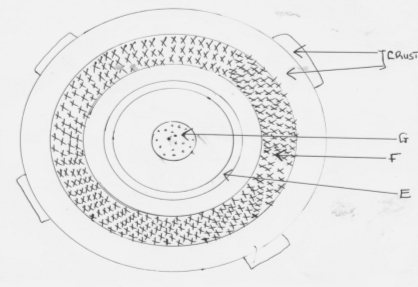
i) Name parts marked E, F and G.
E
F
G
ii) Name the minerals that make the crust.
(c) Give two dates in a year when the number of hours of daylight and darkness are equal.
5. (a) State two theories that have been put forward to explain the origin of the earth.
(b) The diagram below shows a set up of two thermometers use it to answer question (i) and (ii).
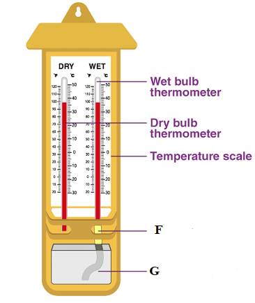
i) Which instrument is represented by the two thermometers?
ii) Name the parts labeled F and G
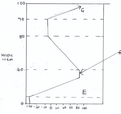
(c)The diagram below represents the structure of the atmosphere. Name parts labeled (3mks)
6. (a ) Identify three areas studied in human geography.
b) Explain four reasons why geography is studied in Tanzania schools.
(c) Name four subjects that relate with geography.
7. a) State three effects of earth’s rotation on its own axis
b) Use a well labeled diagram to show how a lunar eclipse occurs.
c) Explain three proofs that earth is spherical.
8. (a) Define weather
b) Name five elements of weather.
c) State three factors to consider when citing a weather station.
9. (a) Name three types of clouds’.
b) Name three instruments that are kept in the Stevenson’s screen.
c) The data below shows temperature of Arusha town recorded on 24/1/2014
Maximum Temperature 200C
Minimum Temperature 150C
- Calculate diurnal range of temperature for Arusha town.
- Calculate the mean daily temperature for Arusha town.
SECTION C: 15 MARKS
10. Discuss the main challenges facing livestock keeping in Australia
FORM TWO GEOGRAPHY EXAM SERIES 176
FORM TWO GEOGRAPHY EXAM SERIES 176
PRESIDENT OFFICE REGIONAL ADMNISTRATION
AND LOCAL GOVERNMENT
SECONDARY EXAMINATION SERIES
COMPETENCE BASED ASSEMENT
GEOGRAPHY FORM TWO
TERMINAL EXAMS-MAY – 2023
013
Time: 2:30 Hours
Instructions
- This paper consists of sections A, B and C with a total of ten (10) questions.
- Answer all questions.
- Section A and C carry fifteen (15) marks each and section B caries seventy (70) marks
- All writing must be in blue or black ink
- All writing must be written in the space provided.
- Cellular phones, calculators and any unauthorized materials are not allowed in the assessment room.
SECTION A (15 MARKS)
- For items (i) – (x) Choose the correct answer from alternative given and write its leer on spaces provided.
- Places on the east experience sunrise before the place of west because
- The earth rotates from west to east
- The earth rotates from east to west
- earth rotates from north to south
- The earth is closer to the sun
- Which type of mountains results of molten rocks from the earth interior?
- Volcanic mountain.
- Block mountain
- Residual mountain.
- Fold mountain
- What is the time at Lilongwe (40°w) when it is noon at Dodoma (33°E)
- 16:52pm
- 7:08am
- 7:08pm
- .10:52am
- The path used by the earth and other planet when going around the sun is called
- Axis
- Latitude
- galaxy
- Orbit
- Equal length of a day and night when the sun is overhead at the equator is known as
- Equinox
- Solstice
- Summer
- Perihelion
- Which scale is used to draw a map of large area? ( )
- large scale.
- small scale.
- Medium scale
- simple scale
- The nearest planet on the solar system from the sun .
- Mars
- Neptune
- Earth.
- Mercury
- Which water body contains salt water among the following water bodies.
- Lake Victoria.
- Lake Nyasa.
- .Indian Ocean
- Lake Tanganyika
- Which things important in map drawings
- Margin, Key,scale and R.F scale
- Key, scale,tilltle and date of publication
- Scale,frame, tilltle and linear scale
- linear scale,small scale, large scale and medium scale
- Why Stevenson screen is painted white color
- To prevent the sun's heat to reach inside
- To avoid from the dangerous animals. ( )
- To predict weather through observation
- To keep instruments which used measure elements of weather
- Match the items in List A with responses in List B by writing the letter of the correct response below the corresponding item number in the table provided:
| LIST A | LIST B |
|
|
| List A | i | ii | iii | iv | v |
| List B |
|
|
|
|
|
- The table below shows temperature readings at a weather station for one week. calculate the following
| Temp/day | Mo | Tue | Wed | Thu | Fri | Sat | Su |
| Max 0C | 28 | 27 | 28 | 26 | 29 | 29 | 26 |
| Min 0C | 18 | 18 | 20 | 16 | 22 | 21 | 19 |
- Calculate the diurnal range of temperature for Tuesday
- The Mean temperature for Saturday
- Outline five uses of solar energy.
- …………………………………………………………………………………………………………………………….
- …………………………………………………………………………………………………………………………….
- …………………………………………………………………………………………………………………………….
- ……………………………………………………………………………………………………………………………
- ……………………………………………………………………………………………………………………………
- (a) Mention three ways used to express scale of the map
(b)Why cartographer advised to use scale when they decided to draw a map. 3 points
(c) Juma is a lorry driver, he uses map when he travel across the boarders.
What is the importance of map apart from driving . 4 points
- Define the followings terms
- Subsistence farming ____________________________________________________________________________________________________________________________________________________________________________________________________________________________________________________________________________________
- Mixed farming ____________________________________________________________________________________________________________________________________________________________________________________________________________________________________________________________________________________
- Monoculture ____________________________________________________________________________________________________________________________________________________________________________________________________________________________________________________________________________________
- Primary activities ____________________________________________________________________________________________________________________________________________________________________________________________________________________________________________________________________________________
- Secondary activities ____________________________________________________________________________________________________________________________________________________________________________________________________________________________________________________________________________________
- Outline five (5) differences between weather and Climate
………………………………………………………………………………………………………………………………………………………………………………………………………………………………………………………………………………………………………………………………………………………………………………………………………………………………………………………………………………………………………………………………………………………………………………………………………………………………………………………………………………………………………………………………………………………………………………………………………………………………………………………………………………………………………………………………………………………………………………………………………………………………………………………………………………………………………………………………………………………………………………………………………………………………………………………………………………………………………………………………………………………………………………………………………………………………………………………………………………………………………………………………………………………………………………………………………………………………………………………………………………………………………………………………………………………………………………………………………………………………………………………………………………………………………………………………………………………………………………………………………………………………………………………
- List down five resources obtained from Forests
i ........................................................................................................................................................
ii. ......................................................................................................................................................
iii. .......................................................................................................................................................
iv. .......................................................................................................................................................
- ........................................................................................................................................................
- Define the following geographical terminologies
(a)Aphelion (b)Umbra (c)Great circle (d)Meteors
SECTION C (15 Marks)
Choose any one question.
- Explain how East African countries benefited from mining sector. Give six points
- About three quarters of households in sub-Saharan Africa get water from sources located away from their homes, with women and girls bearing the main task of collecting water for their respective households. Elaborate six effects of distance to water sources on the girl-child in Tanzania
FORM TWO GEOGRAPHY EXAM SERIES 146
FORM TWO GEOGRAPHY EXAM SERIES 146
THE PRESIDENT’S OFFICE
MINISTRY OF EDUCATION, REGIONAL ADMINISTRATION AND LOCAL GOVERNMENT
COMPETENCE BASED SECONDARY EXAMINATION SERIES
ANNUAL EXAMINATION
FORM TWO
GEOGRAPHY
013
TIME: 2:30 HOURS May , 2022
![]()
Instructions
1. This paper consists of sections A, B and C.
2. Answer all questions from sections A and B and any two (2) questions from section C.
3. Section A carries twenty five (25) marks, section B forty five (45) marks and section C carries thirty (30) marks.
4. All answers must be written in the spaces provided.
5. All writings must be in blue or black ink except for drawings which must be in pencil.
6. All communication devices, calculators and any unauthorized materials are not allowed in the Examination Room.
7. Write Your Examination Number on the top right of every page.
SECTION A (25 Marks)
Answer all questions in this section.
1. Each of the items (i) - (x), choose the correct answer from the given alternatives and write its letter in the space provided.
(i) What are the basic components of a map?
- Title, key, compass direction, margin and scale
- Conversion table, north direction, contour and key
- Topography, map scale, key and margin
- Grid north, true north and magnetic north
(ii) The following are the measures to improve small scale agriculture in Tanzania except;
- provision of soft loans for improved investment in agriculture.
- encouraging famers to adopt plantation agriculture in rural areas.
- educating farmers on good farming techniques.
- establishment of cooperatives that can assist farmers.
(iii) A scale of the map which is expressed as one centimeter on the map represents one kilometer on ground is called
- Representative fraction
- Linear scale
- Linear scale
- Small scale
(iv) Which set among the following shows the long-term observations of a climate of a place?
- Precipitation, humidity, temperature and wind
- Wind, air-mass, mist, fog and temperature
- Mist, dew point, wind speed and wind direction
- Wind direction, precipitation, humidity and air-mass
(v) Cultivation of cash crops based on application of advanced technology is called?
- Subsistence agriculture
- A large scale agriculture
- Mixed system agriculture
- A small scale agriculture
(vi) When does the summer solstice in the southern hemisphere occurs?
- 21st June
- 23rd September
- 21st September
- 22nd December.
(vii) Time increases by 4 minutes for every 1 ![]() of longitude when one travels from
of longitude when one travels from
- North to South
- East to South
- West to South
- West to East.
(viii)Which type of mountains results from the eruption of molten rocks from the earth interior?
- Volcanic mountains
- Block mountains
- Residual mountains
- Fold mountains
(ix)Which type of climate among the following is different from the other?
- Mediterranean
- Savanna
- Hot desert
- Equatorial
(x)Which one of the following features are correct set of the ocean floor?
- Ridge, basin, plateau and waterfall.
- Continental shelf, basin and waterfall.
- Trench, continental shelf and continental slope.
- Horst, plain and volcano.
2. Match the items in List A with responses in List B by writing the letter of the correct response below the corresponding item number in the table provided.
| LIST A | LIST B |
|
|
3 .In each of the following items (i) - (x), write TRUE if the statement is correct or FALSE if the statement is not correct.
(i)Ocean trenches are also known as submarine plateaus ....
(ii)Equator is not the Great Circle ...
(iii)An eclipse is described as partial when only a part of heavenly body is obscured .........
(iv)Maximum thermometer records both maximum temperature with a day........
(v)Grid reference and bearing are used to determine the position of a place on a map ....
(vi)A scale helps map interpreters to calculate distance, area and computation of other facts....
(vii)Ocean currents are set in motion by prevailing winds .........
(viii)Juvenile water is also referred as underground water .........
(ix)Circumnavigation of the earth is not among the evidence to prove that the earth is spherical......
(x)Uncontrolled deforestation does not expose soil to erosion and extinction of fauna and flora species ..„.
SECTION B (45 Marks)
Answer all questions in this section.
4. The students were watching a video program showing the earth's surface in Tanzania which was irregular. Difference in altitudes and slope give rise to different features and human activities observed in the video program.
(a) Outline five possible features observed by the students.
(b) By giving an example, mention major types of water bodies observed.
(c) Give an example of the main natural basin on the earth's surface observed by the students in the video program
(d) Name four possible types of a large and elevated part of the earth's surface that rise from greater height the students observed.
5. (a) Outline five economic resources which are obtained from water bodies
(i) ………… …………… ………………… ……………
(ii) …………… ……………… ……………… …………
(iii) ………… …………… …………… ……………
(iv) …………… …………… …………… …………… …
(b) Mention five ways of conserving water resources
(i) ………… …………… …………… …………… ……………
(ii) ………… …………… …………… …………… ……………
(iii) …………… …………… …………… …………… ……………
(iv) …………… ……………… ……………… ………………
(v) ……………… ……………… ……………… ………………
(c) List five major means of transport on land.
(i) …………… …………… …………… …………… ……………
(ii) ……………… ……………… ……………… ………………
(iii) ……………… ……………… ……………… ………………
(iv) ……… …… ……………… ………… ……………… …………
(v) …………… …………… …………… …………… ……………
5. Study the sketch map provided and answer the questions that follow:
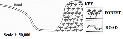
- Name the type of scale which has been used to represent this map.
- Mention three ways which can be used to measure the distance of the road in the sketch map.
- Briefly describe three important basic components of a map.
- Convert the given scale into a statement.
- Mention three methods which can be used to calculate the area of the forest shown on the sketched map.
SECTION C (30 Marks)
Answer two (2) questions from this section.
7. Elaborate five problems facing the development of mining industry in Tanzania.
8. Explain five measures which can be taken to ensure the sustainability of forests in Tanzania.
9. Write a short essay about problems which face the development of the transport sector in Tanzania.
10. What are the negative results of tourism in Tanzania?
FORM TWO GEOGRAPHY EXAM SERIES 98
FORM TWO GEOGRAPHY EXAM SERIES 98
MINISTRY OF EDUCATION, REGIONAL ADMINISTRATION AND LOCAL GOVERNMENT
SECONDARY EXAMINATION SERIES
GEOGRAPHYTERMINALEXAMINATION
FORM TWO-2021
Time: 2:30Hours
Instructions.
- This paper consists of section A, B and C with a total of 10 questions
- Answer all questions in section A and B and TWO questions from section C.
- Section A carries 25 marks, section B 45 marks and section C 30 Marks
- All answers should be written in the spaces provided.
- All communication devices, calculators and any unauthorized material are not allowed in examination room.
- Write your number on every page of your answer booklet.
SECTION A (35 Marks)
Answer All questions in this section.
- For each of the items (i)-(x), choose the correct answer from the alternatives given.
(i) The direction to which compass needle points is called
- Magnetic north
- True north
- Grid north
- Compass bearing
(ii) The condition of the atmosphere recorded for a short period of time is known as
- Climate
- Rainfall
- Weather
- Temperature
(iii) The four seasons of the year are the result of
- Rotation of the earth
- Lunar eclipse
- Revolution of the earth
- Solar eclipse.
(iv) The winds which blow from the sea to land is called
- Wind breeze
- See breeze
- Land breeze
- Ocean current
(v)Which type of mountains results from the eruption of molten rocks from the earth interior?
- Volcanic mountains
- Block mountains
- Residual mountains
- Fold mountains
(vi)Which one of the following instrument is not the component of a weather station?
- Rain gauge
- Wind vane
- Microscope
- Stevenson screen
(vii)The height above the sea level is called:
- Altitude
- Contour
- Latitude
- Ocean
(viii)Which one of the following are block mountains?
- Usambara, Sinai and Himalaya.
- Andes, Atlas and Usambara.
- Usambara, Ruwenzori and Sinai.
- , Uluguru and Usambara.
(ix)A scale of a map is said to be enlarged when:
- its denominator is increased
- its denominator and numerator are the same
- its denominator is reduced
- its numerator is increased
(x)The process whereby water vapour is turned into water droplets is called:
- evaporation
- condensation
- saturation
- transpiration
2.Match the items in List A with responses in List B by writing the letter of the correct response below the corresponding item number in the table provided.
| LIST A | LIST |
|
|
3.
- The continent that is crossed by both tropics of Cancer and Capricorn is Africa .:........
- side of mountain that faces the direction of the wind is known as leeward side .......
- Steroids are solid heavenly bodies revolving around the sun mostly between Mars and Jupiter ......
- (iii)An eclipse is described as partial when only a part of heavenly body is obscured .........
- (iv)Maximum thermometer records both maximum temperature with a day........
- (v)Grid reference and bearing are used to determine the position of a place on a map ....
- A dormant volcano is one that still experiences periodical eruptions
- The rotation of the earth results into four seasons of a year .........
- Any circle which divides a globe into hemispheres is known as great circle ..........
- The Stevenson screen is painted white to reflect light from the moon.
SECTION B (45 Marks)
Answer all questions in this section.
4. (a) Giving one example, briefly explain four main categories of mountain.
(i) …………… …………… …………… ……………
(ii) ……………… ……………… ………………
(iii) …………… ……………… ……………… ………………
(iv) ……………… ……………… ……………… ………………
(b) Briefly explain the formation of rift valleys.
……………… …… ………… ………………
5. (a) Outline four features of Linear Scale
(i) …………… …………………… ……………………
(ii) …………………… …………………… ………………
(iii) …………………… …………………… ………………
(iv) …………………… ……………………… ……………
(b) Briefly describe five essentials of a map
(i) ……………… ………………… ………………………
(ii) ……………… ………………………… …………………
(iii) ……… …………… ……………………… …………
(iv) ……… ………………………… ………………… ……
(v) ……………… ………………… ………………… …
6. Study the sketch map provided and answer the questions that follow:

- Name the type of scale which has been used to represent this map.
- Mention three ways which can be used to measure the distance of the road in the sketch map.
- Briefly describe three important basic components of a map.
- Convert the given scale into a statement.
- Mention three methods which can be used to calculate the area of the forest shown on the sketched map.
SECTION C (30 Marks)
Answer two (2) questions from this section.
7.(a) Outline five evidences to verify that the Earth is spherical.
(b) Differentiate the following terms:
![]() (i) Meteors and satellites
(i) Meteors and satellites
(ii) Sea and lake
8.(a) Outline four ways of determining direction of a place on a map.
9. Describe five factors which enhance a conducive environment for generation of energy.
10.Describe five negative effects of crop cultivation to the environment.
(b) List four features of the Representative Fraction (RF) scale.
(c) Suggest two ways of measuring areas with irregular shapes.
FORM TWO GEOGRAPHY EXAM SERIES 60
FORM TWO GEOGRAPHY EXAM SERIES 60
THE PRESIDENT’S OFFICE MINISTRY OF EDUCATION, LOCAL ADMINISTRATION AND LOCAL GOVERNMENT
GEOGRAPHY- TERMINAL EXAMINATION-MAY
FORM TWO
TIME: 2:30HRS 2020
NAME: _______________________________________________ CLASS: _________
INSTRUCTIONS
- This paper consists sections A , B and C
- Answer All questions in section A and B and two(2) from section C
- All answers should be written in black or blue ink
SECTION A
Answer ALL questions in this section
MULTIPLE CHOICES QUESTIONS
1. For each of the following questions write the letter of the correct answer in the boxes provided below:
(i) An angular distance measured in degrees East and West of the Prime Meridian:-
- Equator
- Latitude
- Longitude
- Tropic of cancer
(ii) One of the common characteristics between nomadic pastoralism and shifting cultivation is that people have:
- Advanced in technology
- Good standard of living
- High crop production
- No permanent settlement
(iii) The wise use and control of water resources is known as water:
- Controlling
- Development
- Management
- Resources
(iv) Although the earth is in motion all the time we don’t feel its motion. This is due to the reason that we are:
- In the earth
- Moving against the motion
- Moving with it
- On the earth
(v) The major features rising above the surface of ocean water and important for tourism are called:
- Continental shelf
- Continental slope
- Ocean island
- Ocean plain
(vi) The solar eclipse occurs when:
- One body passes between the two bodies
- The earth passes between the moon and the sun
- The earth passes between the sun and the moon
- The moon passes between the earth and the sun
(vii) The farthest position of the earth from the sun is known as:
- Aphelion
- Equinox
- Perihelion
- Solstice
(viii) The occurance of summer, winter, autumn and spring is a result of:
- Ferrel’s law
- Revolution of the earth
- Tilting of the earth on its axis
(ix) The height above sea level is called
- Altitude
- Contours
- Latitudes
- Ocean
(x) Which one of the following was the smallest planet in the solar system?
- Earth
- Mercury
- Pluto
- Venus
2. Matching items. Select an item from group B and match it with the corresponding item in group A
| LIST A | LIST B |
| (i) Tourism (ii) Mining (iii) Trade and commerce (iv) Sedentary livestock (v) Physical landscape, atmosphere, natural vegetations
|
|
3. The following statements are either correct or incorrect. Write TRUE if the statement is correct or FALSE if the statement is not correct:
- Circumnavigation of the earth is not the evidence to prove that the earth is spherical ________________
- Crossing the international date line causes the gauzing or losing a day _______________
- Forests are sources of medicine ____________
- Geography deals with the earth’s features only ___________
- Light industries involve manufacturing of heavy and bulky products ___________
- The time within a particular area is termed as local mean Time (L.M.T) ___________
- Good railways and road networks stimulate economic development ___________
- Industrial activities have no negative impacts on environment _____________
- Lake Victoria is within the Rift Valley _____________
- Trenches and ocean deeps are the same relief features of the river basin ____________
4. (a)Define the term “temperature”
(b) Study carefully the climatic data given for station Y and then answer the questions that follow:
| Months | J | F | M | A | M | J | J | A | S | O | N | D |
| Temp(oC) | 28 | 27 | 27 | 27 | 28 | 28 | 26 | 25 | 24 | 26 | 27 | 28 |
| Rainfall(mm) | 2400 | 2100 | 2050 | 1750 | 1700 | 1750 | 1660 | 1500 | 1700 | 1805 | 2100 | 2300 |
- Calculate the annual mean temperature
- Calculate the amount of annual rainfall
- Determine the annual range of temperature
- Suggest the type of climate at station Y
SECTION B
Answer ALL questions in this section
5. (a) Briefly explain the concept of human activities.
(b) Name four types of primary human activities.
(c) Giving two examples, differentiate between primary and secondary human activities.
6. (a)Explain the term map
(b) With examples explain the following types of maps:
- Topographical maps
- Statistical maps
(c) Examine five (5) characteristics of a good map:
SECTION C
Attempt two questions
7. Discuss the significance of atmospheric pressure in life (5 points)
8. How walking long distance to the water sources affect the girl child? Explain (5 points)
9. Describe ways of improving subsistence small scale agriculture. (5 points)
10.(a) What is river basin development project?
(b) Examine the importance of river basin development projects in Africa (4 points)
FORM TWO GEOGRAPHY EXAM SERIES 17
FORM TWO GEOGRAPHY EXAM SERIES 17

DOWNLOAD LEARNING HUB APP NOW

SORRY, YOU CAN'T VIEW THIS MARKING SCHEME PLEASE DOWNLOAD LEARNING HUB APP FROM PLAYSTORE TO GET FULL ACCESS TO ALL MARKING SCHEME!!
Click Here To Download Learning Hub Tanzania App
SAMAHANI, HUWEZI KUFUNGUA MAJIBU YA MTIHANI, TAFADHALI PAKUA APP YA LEARNING HUB TANZANIA ILI KUWEZA KUFUNGUA MAJIBU YA MITIHANI KATIKA TOVUTI HII!!
Bofya Hapa Kupakua App Ya Learning Hub Tanzania
Hub App
 For Call,Sms&WhatsApp: 255769929722 / 255754805256
For Call,Sms&WhatsApp: 255769929722 / 255754805256  Matokeo Darasa VII 2025
Matokeo KIDATO CHA II 2024
Matokeo Darasa IV 2024
SECONDARY REGIONAL EXAMS
PRIMARY REGIONAL EXAMS
FORM VI NECTA REVIEWS
FORM IV NECTA REVIEWS
FORM II NECTA REVIEWS
STD VII NECTA REVIEWS
STD IV NECTA REVIEWS
SECONDARY EXAMS SERIES
PRIMARY EXAMS SERIES
PRIMARY SUBJECT NOTES
SECONDARY SUBJECT NOTES
SECONDARY TOPICAL EXAMS
SECONDARY TOPICAL QUESTIONS
PRIMARY TOPICAL QUESTIONS
PRACTICAL EXAMS & NOTES
SECONDARY REGIONAL EXAMS
DOWNLOAD SUBJECT NOTES
SCHEMES OF WORK (PRIMARY & SECONDARY)
LESSON PLAN
SECONDARY LOG BOOKS
PRIMARY LOG BOOKS
LITERARY WORKS / UCHAMBUZI VITABU
METHALI ZOTE ZA KISWAHILI
Vitendawili Vya Kiswahili
FORM VI RESULTS 2024
FORM FIVE SELECTION 2024
MATOKEO KIDATO CHA IV 2023
FORM ONE SELECTION 2024
FORM VI RESULTS 2023
Matokeo Darasa IV 2022
Matokeo Darasa VII 2025
Matokeo KIDATO CHA II 2024
Matokeo Darasa IV 2024
SECONDARY REGIONAL EXAMS
PRIMARY REGIONAL EXAMS
FORM VI NECTA REVIEWS
FORM IV NECTA REVIEWS
FORM II NECTA REVIEWS
STD VII NECTA REVIEWS
STD IV NECTA REVIEWS
SECONDARY EXAMS SERIES
PRIMARY EXAMS SERIES
PRIMARY SUBJECT NOTES
SECONDARY SUBJECT NOTES
SECONDARY TOPICAL EXAMS
SECONDARY TOPICAL QUESTIONS
PRIMARY TOPICAL QUESTIONS
PRACTICAL EXAMS & NOTES
SECONDARY REGIONAL EXAMS
DOWNLOAD SUBJECT NOTES
SCHEMES OF WORK (PRIMARY & SECONDARY)
LESSON PLAN
SECONDARY LOG BOOKS
PRIMARY LOG BOOKS
LITERARY WORKS / UCHAMBUZI VITABU
METHALI ZOTE ZA KISWAHILI
Vitendawili Vya Kiswahili
FORM VI RESULTS 2024
FORM FIVE SELECTION 2024
MATOKEO KIDATO CHA IV 2023
FORM ONE SELECTION 2024
FORM VI RESULTS 2023
Matokeo Darasa IV 2022


