THE UNITED REPUBLIC OF TANZANIA, PRIME MINISTR'S OFFICE-RALG
FORM THREE SEPTEMBER MID–TERM EXAMINATIONS
013 GEOGRAPHY
(For Both Private and School Candidates)
Time: 3:00 Hours Year: 2026
Instructions
- This paper consists of sections A, B and C with a total of eleven (11) questions.
- Answer all questions in sections A and B and two (2) questions from section C.
- Section A carries sixteen (16) marks, section B fifty four (54) marks and section C carries thirty (30) marks.
- Map extract of HANANG (sheet 84/4) is provided.
- Except for drawings which must be drawn in pencil, all writings must be in blue or black ink.
- Non programmable calculators, cellular phones and any unauthorized materials are not allowed in the examination room.
- Write your Name in Full on every page of your answer booklet(s).
SECTION A (16 Marks)
Answer all questions in this section
1. For each of the items (i) – (x) choose the correct answer from among the given alternatives and write its letter besides the item number in the answer booklet(s) provided.
(i) Assume you are asked to help the form one student who failed to identify the type of Geography which deals with the study of physical features. What type of Geography will you suggest among the following?
- Human and economic geography
- Practical geography
- Mathematical geography
- Physical geography
- Human geography
(ii) When traveling in a fast moving vehicle, we notice trees and other objects on both sides of the road moving in opposite direction. This shows that the point of observation (the earth) is moving by rotation from:
- West to East
- East to West
- East to South
- West to North
- West to South
(iii) The layer of atmosphere characterized by 16 kilometers thick at the equator, temperature decrease with an increase in altitude and its boundary with the next layer is known as tropopause. The layer is:
- Stratosphere
- Mesosphere
- Thermosphere
- Exosphere
- Troposphere
(iv) Mr. Kijazi and their students visit at a certain National Park in Tanzania and see the thick forest, tree dwellers, animals and people who engage in cultivation of cocoa and coffee. What type of forest will you suggest among the following to represent the information above?
- Tropical Savannah
- Equatorial
- Mediterranean
- Tropical monsoon
- Polar Climate
(v) The navigable rivers in East Africa include Rufiji, Ruvuma, Tana and Nile. Unfortunately, most of the rivers are of limited use for navigation. This is due to:
- Rapids or waterfalls
- Large amount of silt
- Large volume of water
- Presence of dangerous animals
- Some rives disappear
(vi) Mr. Mengi was interested in developing energy from the remains of living organizations. What will be best raw materials for Mr. Mengi’s project?
- Coal
- Petroleum
- Natural gas
- Solar energy
- Running erosion
(vii) Form three students at Mnazi Bay Secondary make survey in Kondoa district and identify different types of soil erosion. One of the following is not a type of soil erosion. That is:
- Splash erosion
- Sheet erosion
- Lateral erosion
- Rill erosion
- Gull erosion
(viii) Exfoliation is the process of peeling of rocks. Which of the following is the cause of exfoliation?
- Bush fires
- Running water
- Air in motion
- Hydrolysis
- Hydration
(ix) From 2015 Tanzania is struggling to transform her economy from agricultural-based to industrial-based, but one of the effects of industry base economy is pollution. Identify four (4) types of pollution which are caused by Tanzania industry among the following sets:
- Soil, water, noise and air pollution
- Nuclear, land, noise and air pollution
- Radiation, water, air and noise pollution
- Air, noise, water and nuclear pollution
- Land, noise, population and stubborn pollution
(x) A coral is the limestone rock formed below the low-level tides as the result of the deposition of skeletons of minute sea organism called polyps. In which of the following conditions do the polyps survive?
- Muddy salt water
- Calcium carbonate mineral in water, 60m below mean sea level, aerated water, hot sea water and extensive long shore movement
- Muddy river water about 50C to 100C of the water and 30m to 40m depth
- Sunlight, rock platform, warm ocean water, mean sea level se organism
- Salty sea water, about 20C to 250C aerated water, planktons and 30m to 40m depth of the sea
2. Match the description of rocks in List A with the correct minerals in List B by writing the letter of the correct response beside the item number in the answer sheets provided.
| LIST A | LIST B |
|
|
SECTION B (54 Marks)
Answer all questions in this section
3. Study the map extract of HANANG (84/4) provided and then answer the following questions.
(a) Calculate the approximate area of Balangida (salt and soda) lake on the mapped area in kilometer squares.
(b) With evidences from the map, identify three (3) main ways used to depict relief features on the mapped area.
(c) Relate the main relief feature and settlement pattern shown on the mapped area.
(d) With reasons, describe three (3) rocks types shown on the map.
(e) State the vertical contour interval (V.I) used in this topographical map.
(f) By using evidences on the map, discuss four (4) main land use pattern shown on the mapped area.
4. Consider the data below about maize production at Morogoro (“000” tones) from 1980 to 1984 and then answer the questions that follow.
| YEAR | 1980 | 1981 | 1982 | 1983 | 1984 |
| MAIZE PRODUCTION | 900 | 750 | 800 | 400 | 300 |
(a) Present the data above by drawing the divergence bar graph
(b) Describe any two (2) advantages of the method you have mentioned in (a) above
(c) Briefly describe the steps or procedures taken to construct the divergence bar graph.
5. Atmospheric pressure is unequally distributed on the earth’s surface. Examine six (6) factors influencing atmospheric pressure variations.
6. Carefully examine the photograph below and then answer the questions that follow.

(a) Mention two (2) characteristics of this type of photograph.
(b) Briefly explain the process that led to the formation of the feature shown above.
(c) Identify three (3) differences between the photograph shown above and topographical maps.
(d) Comment on economic importance of the area. Provide three (3) points.
7. Form three candidates carried a study tour to Hale hydroelectric power station where and observed falling water in a river course disturbed by a wheel flow of water which caused the water wheel rotate.
(a) Name the feature with steep gradient that the candidates observed.
(b) Describe the feature named in (a) above.
(c) With the aid of diagram, describe how the feature named in (a) can lead to the formation of plunge pool.
8. Form four students visited the river mouth of Rufiji river and found the river pours in water into the Indian Ocean by spreading many small channels called distributaries covering a wide flat land with alluvium deposit forming a triangular shaped feature.
(a) Identify the feature observed by form four students.
(b) Describe four (4) conditions necessary for the formation of the feature named in (a) above.
(c) Briefly explain four (4) importance of the feature named in (a) above.
SECTION C (30 Marks)
Answer two (2) questions in this section
9. Anna and her friend Jenifer were travelling from Kibaha to Arusha. Along the road, they saw people selling rocks. “What type of that rocks? Anna asked Jenifer. ‘Those are sedimentary rocks from Tanga. Generally, those rock are important to our daily lives.” Jenifer answered. In six (6) points, support Jenifer’s words.
10. Forest is among the resources in Tanzania that we have been naturally gifted. What variety of forest would you explain to the form two students who failed to identify the classes of forests that occurred naturally in the world?
11. “Manufacturing industry plays a great role to the economic development of a country.” Clarify six (6) constrains which face the development of textile industry in Tanzania.
FORM THREE GEOGRAPHY EXAM SERIES 281
FORM THREE GEOGRAPHY EXAM SERIES 281


FORM THREE GEOGRAPHY EXAM SERIES 210
FORM THREE GEOGRAPHY EXAM SERIES 210
FORM THREE GEOGRAPHY EXAM SERIES 209
FORM THREE GEOGRAPHY EXAM SERIES 209
OFISI YA RAIS, TAWALA ZA MIKOA
NA SERIKALI ZA MITAA
JAMUHURI YA MUUNGANO YA TANZANIA
MTIHANI WA NUSU MUHULA
KIDATO CHA TATU
KISWAHILI 2024-AUG/SEPT
- Maelekezo
- 1. Karatasi hii ina sehemu A, B na C zenye jumla ya maswali kumi (10).
- 2. Jibu maswali yote kwenye nafasi ulizopewa.
- 3. Sehemu A na C zina alama kumi na tano (15) kila moja na sehemu B ina alama sabini (70).
- 4. Zingatia maelekezo ya kila sehemu na ya kila swali.
- 5. Majibu yote yaandikwe kwa kalamu yenye wino wa bluu au mweusi.
- 6. Vifaa vyote vya mawasiliano visivyoruhusiwa havitakiwi katika chumba cha upimaji.
- 7. Andika Namba yako ya Upimaji katika kila ukurasa sehemu ya juu upande wa kulia.
SEHEHU A
Jibu maswali yote katika sehemu hii.
1. Chagua Chagua herufi ya jibu sahihi katika vipengele (i) hadi (x), kisha andika herufi ya jibu hilo kwenye kijitabu chako cha kujibia.
(i) Sentensi ipi kati ya hizi zifuatazo HAINA maana Zaidi ya moja?
- Kaka amefua nguo
- Nipe sahani ya kulia
- Suedi amenunua mbuzi
- Eva amenunua kanga
- Joni amempigia mpira
(ii) Kiimbo hutafsiriwaje katika mazungumzo?
- Kupanda na kushuka kwa mawimbi ya sauti
- Kuzungumza na kuongea kwa sauti
- Kuzungumza kwa kupandisha mawimbi ya sauti
- Kuzungumza kwa kushusha mawimbi ya sauti
- Kuzungumza na kushuka kwa mawimbi ya sauti
(iii) Mkisi ameenda Dodoma. Neno Dodoma limetumika kama aina gani ya neno?
- Kielezi
- Nomino
- Kivumishi
- Kiwakilishi
- kihisishi
(iv) “Changa bia” nahau hii katika lugha ya Kiswahili ina maana ipi?
- Kuepuka matatizo kwa ujanja
- Fika mwisho
- Kula kwa ushirika
- Chombo kipo hatarini
- Kumaliza kikao
(v) Mawazo makuu ya mtunzi wa kazi za fasihi humfikia mlengwa kwa njia ipi kati ya hizi zifuatazo?
- Fani
- Maudhui
- Dhamira
- Falsafa
- Migogoro
(vi) Ipi ni tofauti ya msingi kati ya mashairi na ngonjera?
- Mpangilio wa vina na mizani
- Idadi ya mizani na mishororo
- Majibizano baina ya watu wawili au Zaidi
- Mpangilio maalumu wa silabi na lugha ya mkato
- Mapigo ya kimuziki na ridhimu
(vii) Jambo gani muhimu huzingatiwa na mtunzi wa insha ya hoja?
- Lugha yenye ukinzani
- Lugha ya kisanaa
- Lugha isiyo na mvuto
- Lugha ya kufikirisha
- Lugha inayosifia
(viii) Uwasilishaji wa kazi za fasihi unatofautiana kati ya mtunzi mmoja na mwingine huitwaje?
- Muundo
- Mtindo
- Maudhui
- Falsafa
- Fani
(ix) Unyambulishaji katika lugha ya Kiswahili huhusisha upachikaji wa viambishi___
- Kabla ya mzizi
- Katikati ya mzizi
- Baada ya mzizi
- Kabla na baada ya mzizi
- Kabla, katikati na baada ya mzizi
(x) Ili kuepuka utata katika tungo, ni muhimu
- Kuepuka matumizi ya maneno yenye maana Zaidi ya moja
- Kutumia nahau
- Kutumia aina zote za maneno katika tungo
- Kutumia alama za uandishi
- Kutumia mofu ya kauli ya kutendea
2. Oanisha dhana za nyimbo zilizopo katika ORODHA A na aina ya nyimbo katika ORODHA B Kisha andika herufi ya jibu sahihi katika kijedwali hapo chini.
| ORODHA A | ORODHA B |
|
|
SEHEMU B.
Jibu maswali yote katika sehemu hii.
3. (a) Eleza dhima za mofimu “li” kama ilivyotumika katika sentensi zifuaatazo:-
- Shamba letu li kubwa sana.
- Walichelewa kurudi.
- Tunalifuatilia
- Limeharibika
- Shikilia
(b) Andika sentensi zifuatazo katika hali ya ukanushi.
- Ameshiba sana
- Watoto wengi wanaogelea
- Mvua ilinyesha kwa wingi sana
- Kijana anakula chakula kingi sana
4. (a) Utata katika mawasiliano husababishwa na mambo mengi.Taja sababu Tano (5) zinazosababisha Utata katika lugha.
(b) "Tabibu mzuri ni yule anayejua njia za kutibu ugonjwa"ukitumia msemo huu onesha njia nne (4) zinazoweza kuondoa Utata katika lugha.
5. "Mwalimu wa kidato Cha nne aliwaambia wanafunzi wake waunde maneno mapya."Bainisha njia Tisa (9) walizozitumia kuunda maneno hayo na Kwa Kila njia toa mfano mmoja.
6. Malimusi na Wasakatonge walikuwa wanajadili kuhusu tenzi na mashairi , Malimusi anasema tenzi na mashairi zote ni tungo za kishairi hivyo zinafanana lakini Wasakatonge alikinzana na Malimusi kwa hoja kuntu. Jadili upande wa Wasakatonge kwa hoja sita (6) huku ukitolea mifano hoja zako.
7. Asasi mbalimbali zilizoanzishwa kabla na baada ya Uhuru,mfano UKUTA (1959) na TATAKI(2009) Kwa lengo la kukuza na kuendeleza kiswahili.Onesha changamoto SITA sinazozikumba asasi hizo katika ukuzaji wa kiswahili.
8. Soma kifungu cha habari kisha jibu maswali yafuatayo.
Ndugu wazazi,kumbe safari yenu inahusu harusi ya Zaituni? Mkuu wa shule aliwauliza wazazi “ndiyo” wazazi walijibu kwa Pamoja bila aibu. “inategemewa kufungwa lini”? mkuu aliendelea kuhoji. Harusi hii ilikuwa ifanyike wakati zaituni anapofika kidato cha nne,lakini zainabu huyu ametufanyia uhuni na vituko visivyoelezeka . nasi sasa tunachukiwa na Kijiji kizima na kudharauliwa na kila mtu.
Hii imetuudhi sana, tumetungiwa nyimbo na kufanyiwa kila shutuma. Hatuna raha; hivyo tumeonelea bora tuje kukuomba umfukuze shule ili kiburi kimwishe.
Nasi tupo tayari kukulipa kiasi chochote cha fedha ukitimiza haja yetu hii, “mzee Abdallah alieleza”. Muda wote mkuu wa shule alikuwa akimtazama mzee kwa chata sana.Kisha akauliza swali la kuchochea Zaidi, “zaituni ana kiburi kumbe”
Mama Zaituni hakutaka hilo limpite himahima akatoa maelezo yake. “Mama wewe, zaituni usimuone hivi”. Zaituni mwanangu hataki kufuata utamaduni wetu wa kuolewa. Zaituni ati achague mchumba mwenyewe, ati mahari haioni kama ni kitu cha msingi. Kiburi hicho kinatokana na elimu mliyompa. Mtoto sasa ameharibika. Anafanya apendavyo, elimu gani isiyojali adabu, wala utii?” mama zaituni alimaliza huku jasho na machozi yanamtoka.
Hapa mkuu wa shule aliona kwanza awaelimishe kabla hajawatolea kauli ya mwisho. Alikwishatambua kwamba wazazi wa zaituni walikuwa wameachwa nyuma na wakati. Kila upya wa mawazo waliuita kiburi.
MASWALI
- Wazazi wa Zaituni walikwenda shuleni kufanya nini?
- Wazazi walisema kuwa Zaituni amefanya kosa gani?
- Eleza mgogoro mkuu uliopo kati ya Zaituni na wazazi wake.
- Fupisha Habari hiyo kwa maneno yasiyopungua hamsini( 50) na yasiyozidi sitini(60).
SEHEMU C.
Jibu maswali mawili (2) kutoka katika sehemu hii, Swali la kumi ni lalazima.
ORODHA YA VITABU
USHAIRI
- Wasatonge – M. S Khatibu (DUP)
- Malenga wapya - TAKILUKI (DUP)
- Mashairi ya chekacheka - T. A. Mvungi (EP& D. LTD)
RIWAYA
- Takadini - Ben. J. Hanson (MBS)
- WAtoto wa mama N’tilie - E. Mbogo(H.P)
- Joka la mdimu - A. J. Safari (H.P)
TAMTHILIYA
- Orodha - Steve Reynolds (M)
- Ngoswe penzi kitovu cha uzembe - E. Semzaba(ESC)
- Kilio Chetu - Medical Aid Foundation (TPH)
9. Msanii yeyote wa kazi ya fasihi anafananishwa na mwavuli kwa jamii yake, kwa kuwa anatumia macho yake kuona maovu yaliyomo katika jamii na hutumia kalamu yake kuishauri na kuikinga jamii yake isipatwe na mabaya. Thibitisha kauli hii kwa kudadavua maovu yaliyoibuliwa na waandishi wa riwaya mbili ulizosoma. Hoja tatu kwa kila riwaya.
10. Waandishi wengi wa fasihi hupenda kutumia jazanda mbalimbali katika kuelimisha jamii katika maswala kadha wa kadha.Hivyo tumia jazanda mbalimbali kutoka diwani mbili ulizosoma kuonesha walivyosaidia kuelimisha jamii.Toa hoja tati(3)wa Kila kitabu.
11. "Uibushaji WA migongano katika tamthiliya ni nyenzo muhimu katika ufanikishaji wa tamthiliya "Kwa kutumia vitabu viwili(2)kati yavile ulivyosoma,Jadili kauli hii Kwa kutoka hoja tati (3) Kwa Kila kitabu.
FORM THREE GEOGRAPHY EXAM SERIES 181
FORM THREE GEOGRAPHY EXAM SERIES 181
THE PRESIDENT’S OFFICE
REGIONAL ADMINISTRATION AND LOCAL GOVERNMENT
SECONDARY EXAMINATION SERIES
MID TERM ONE EXAMINATION, AUG/SEPT -2024
FORM THREE
GEOGRAPHY
INTRUCTIONS TIME:2:30
- This Paper Consist Two Section A & B With A Total Of Twelve (12) Questions.
- Answer All Questions In Section ‘’A ‘’ And Two Question From Section ‘’B’’
- Section “A” Caries Seventy (15) Marks , Section B’’ Thirty (30) Marks.
- Programmable Calculator , Cellular Phones And Any Unauthorized Materials Are Not Allowed In The Examination Room.
- Write Your Name On Every Page Of Your Answer Sheet.
SECTION A (70-MARKS)
ANSWER ALL QUESTIONS FROM THIS SECTION.
i. A city located very close to the Equator is likely to experience:
- Short days and long nights all year
- Very cold winters and hot summers
- Hot temperatures and roughly equal day/night length all year
- Four distinct seasons
ii. Which of the following is not an element of weather?
- Humidity
- Precipitation
- Sunshine
- Climate
iii. Mountains which are formed by the process of denudation are referred to as:-
- Fold mountains
- Residual mountains
- Block mountains
- Volcanic Moutains
iv. Understanding how different cultures interact with their environment is important because:
- It can help us build maps
- We can learn how people used to live
- It helps us make choices that protect the planet
- It tells us who the best explorers were
v. Which one of the following is not a factor to consider while deciding the climate of a place?
- Prevailing winds
- Annual rainfall
- Distance from the ocean
- Annual range of temperature.
vi. Among the following is the only problem associated with over exploitation of forest resources.
- Desertification
- Low technology
- Poor transport and communication
- Poor capital to be used.
vii. The production of bulk products like iron, steel, car assembly and ship building is referred to as:-
- Heavy industry
- Simple or light industry
- Secondary industry
- Primary industry
viii. Solar energy coming from the sun is referred to as:-
- Renewable energy resource
- Non – renewable energy resource
- Tidal power source
- Hydroelectric power.
ix. Water transport is also referred to as:-
- Marine transport
- Sea transport
- River transport
- Lake transport
x. Total volume of pores or empty spaces between soil particles is termed as;
- Soil texture
- Soil porosity
- Soil structure
- Soil profile
2. Match the items from LIST A with the correct response in LIST B by writing a letter of the correct answer.
| LIST A | LIST B |
|
|
SECTION B
3. Explain how the following factors determine soil formation?
i) Parent rock material
ii) Climate
iii) Living organisms
iv) Relief
v) Topography.
4. (a) What do you understand by:-
- Nominal scale
- Ordinal scale
- Interval scale
- Ration scale
(b) Differentiate parametric and non – parametric data
5. Explain the importance of glacial erosional and depositional features.
6. Explain the differences between mechanical, chemical, and biological weathering, providing examples of each.
7. What are the factors that have influenced the development of car manufacturing industry in Japan?
8. (i) Classify rocks according to mode of formation.
(ii) Identify three minerals that are found in igneous rocks.
9. Carefully study the photograph provided below and then answer the questions that follow
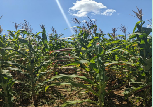
- Name the crop shown in the photograph
- Mention three necessary physical conditions for the growth of the
- With two reasons determine the type of photograph
- Mention two contributions of economic activity taking
10. List the advantages and disadvantages of air transport.
SECTION C-ANSWER QUESTION 11
11. What are the factors that favour the development of Hydro electric power (H.E.P)?
FORM THREE GEOGRAPHY EXAM SERIES 180
FORM THREE GEOGRAPHY EXAM SERIES 180
THE PRESIDENT’S OFFICE
REGIONAL ADMINISTRATION AND LOCAL GOVERNMENT
SECONDARY EXAMINATION SERIES
MID TERM ONE EXAMINATION, AUG -2023
FORM THREE
GEOGRAPHY
INSTRUCTIONS TIME:2:30
- This Paper Consist Two Section A & B With A Total Of Twelve (12) Questions.
- Answer All Questions In Section ‘’A ‘’ And Two Question From Section ‘’B’’
- Section “A” Caries Seventy (15) Marks , Section B’’ Thirty (30) Marks.
- Programmable Calculator , Cellular Phones And Any Unauthorized Materials Are Not Allowed In The Examination Room.
- Write Your Name On Every Page Of Your Answer Sheet.
SECTION A (16-MARKS)
ANSWER ALL QUESTIONS FROM THIS SECTION.
- For each of the items(i-x) choose the correct answer from among the given alternatives and write its letter in the answer sheet.
- Why does the sun appear large than other stars that are seen at night?
- The capacity of our eyes does not view far during the night.
- The sun is closer to the earth than other stars.
- The earth’s atmosphere filters out light from other stars.
- Daylight brightness the sun making it appear large.
- Which layer of the earth forms the ocean floor?
- Mantle
- Sial
- Sima
- Crust
- In the field study students were told that , soil has a certain biological, chemical and physical characteristics. what is the general term for these characteristics?
- Soil profile
- Soil particle
- Soil properties
- Soil formation
- A girl was crossing a river and accidentally dropped her school bag in the river the girl cried as she observed her beg being pulled by river water toward the river mouth . what could the bag named in relation to the river action?
- River erosion
- River transportation
- River load
- River bed
- Husna and his young brother Hamid like to play with wet soil around their home . they enjoy observing quick percolation of water in the soil . what type of soil were they playing with?
- Clay
- Silt
- Sand
- loam
- which among the following is an extrusive volcanic features?
- Dykes
- crater
- Sills
- Batholiths
- One of the factors for soil formation is
- Organic matter
- Mineral matter
- Water
- Air
- The layer of atmosphere which is nearer to the earth’s surface is called.
- Troposphere
- Stratosphere
- Mesosphere
- Thermosphere
- Which of the following is not a process for chemical weathering
- Carbonation
- Saltation
- Hydration
- Oxidation
- Which among the following features are produced by wave erosion.
- Geo, wave cut platform and stack
- Blow hole, sea arch and levee.
- Tombolo , meander and cliff.
- Match the process involved in the formation of rocks in list A with the type of rock in list B by wring the letter of the corresponding response beside the item number in the answer booklet provided.
| LIST A | LIST B |
|
|
- A. define the following terms.
- Distributaries
- Lagoon
- Levee
- Delta is formed under different conditions. Outline three conditions necessary for its formation
- Explain the function of the following survey tools
- Arrow
- Pegs
- Ranging rod
- Beacon
- Tape measure
- Explain why temperature in the stratosphere increases with the increase in height while the mesosphere experiences a decrease in temperature as height increase.
- Describe the importance of water in the soil.
- What would you do to overcome obstacles such as pond in a chain survey?
- A. Define the term soil
- Briefly explain four importance of soil to human life.
- Mention three sources of soil nutrients.
SECTION ‘’ B’’ 30-MARKS
ANSWER ANY TWO QUESTIONS FROM THIS SECTION .
- (a) Describe discordant drainage system
(b) Explain the process of river transport and describe four ways in which a river transports its load.
10. (a) Explain two major forms of measurements in land surveying.
(b) (i) Define leveling
(ii) Explain four significances of leveling.
- With the aid of diagram show the layer of atmosphere and describe the characteristics of each layer.
- Show how human population growth relate with the rate of soil erosion.
FORM THREE GEOGRAPHY EXAM SERIES 143
FORM THREE GEOGRAPHY EXAM SERIES 143
THE PRESIDENT’S OFFICE MINISTRY OF EDUCATION, REGIONAL ADMINISTRATION AND LOCAL GOVERNMENT
COMPETENCY BASED SECONDARY EXAMINATION SERIES
GEOGRAPHY-SEPT 2022
FORM THREE
INSTRUCTIONS
- This paper consists of sections A, B and C with a total of ten (10) question.
- Answer All questions in sections A and B and any two (2) questions from section C.
- Map extract of LINDI is provided
- Cellular phones are NOT allowed in the examination room.
- Write your Examination number on every page of your answer booklet (s)
SECTION A (15 MARKS)
PHYSICAL AND MATHEMATICAL GEOGRAPHY
- For each of the items (i) – (x) choose the correct answer from the given alternatives and write its letter besides the item number.
- Which of the following planets is closest to the sun?
- Earth
- Jupiter
- mars
- Mercury
- Neptune
- Overgrazing in Tanzania can lead to environmental problems. Identify the regions might have been affected by the problem;
- Dodoma, Arusha and Shinyanga
- Morogoro, Dar es salaam and Tanga
- Pwani, Mbeya and Rukwa
- Mwanza , Singida and Tabora
- Manyara , Iringa and Dodoma
- when the moon’s shadow casts over the earth’s surface the phenomenon is known as
- Lunar eclipse
- Solar eclipse
- Equinoxes
- Summer solstice
- Winter solstice
- What are the four types of statistical data basing on their nature?
- Individual data, discrete data, raw data and secondary data
- Individual data, discrete data , grouped data and continuous data
- Primary data, secondary data, grouped data and collective data
- Individual data, grouped data, statistical data and discrete data
- Raw data, continuous data , primary data and array data
- The Earth have different evidences that proves that the Earth is spherical. What do you think that this is one among those evidences?
- The four seasons
- The lunar eclipse
- The revolution of the Earth
- The Earth rotation
- The eclipse of the sun
- A drainage pattern which works like a tree with its branches is called
- Radial
- Dendritic
- Centripetal
- Annual
- Trells
- The following arc the element of weather
- Soils, clouds, dew, humidity, rainfall
- Pressure, clouds, sunshine, humidity, winds
- Fog, barometer, humidity, pressure, air mass
- Pressure, humidity, soil, fog, rainfall
- Clouds, sunshine, pressure, humidity, thermometer
- The process of peeling off of rock mass is called
- Disintegration
- Weathering
- Mass wasting
- Erosion
- Exfoliation
- A vertical feature formed out of the solidification of magma within the Earths crust is called
- Localita
- sill
- lopolith
- Dykc
- Phacolith
- Mrs Kilua was wondering how fragments are worn out during collision against each other at Kondoa river during rainy season, her daughter tells her that process is known as ……
- Hydraulic action
- Attrition
- Abrasion
- Corrosion
- Hydrolysis
- Match the items in List A with responses in List B by writing the letter of the correct response beside the item number in the answer booklet provided.
| LIST A | LIST B |
|
|
SECTION B 55 MARKS
Answer all questions in this section
3. Carefully study the map extract of Kigoma (sheet 92/3) provided and answer the following questions;
(a) Identity the features that found in the following grid references
- 923617
- 945599
- 910596
(b) Calculate the area of lake Tanganyika from 570 Southward. Give your answer in Km2
(c) What is the length of the railway line from grid reference 944633 Eastward. Give your answer in Km.
(d) With evidence suggest the type of settlement patterns depicted in the map.
(e) By providing evidences, explain three (3) human economic activities andtwo (2) social activities that might be taking place in the area.
4. Study carefully the data below that show the enrollment of form six students at Bagamoyo secondary school from 1980-1985 the answer the questions that follows;
| YEAR | NUMBER |
| 1980 1981 1982 1983 1984 1985 | 100 150 175 200 225 300 |
a) Present the data above by pie chart
b) Comment on the trend of the pie chart in (a) above
c) What are the merits of using this method Apart from that method use in (a) above. Give three (3) points
d) What are alternative methods that can be used to present the data above? Give two (2) points.
5 (a) Mary is a good cartographer; she intends to produce a contoured map of Morogoro. What type of survey method would you advise her to apply?
(b) Apart from producing contour maps, what is the other significance of the survey you have mentioned in (a) above
(c) Mention and explain uses of any three instruments which are used in method you mentioned in (a) above
6. Most of the students usually get confusion when they are trying to differentiate some terms. As a form three student how can help those students to attempt for the following?
a) Small holder farmers and subsistence farming
b) Connate water and juvenile water
c) Adit mining and panning method
d) Footloose industries and industrial inertia
e) Shooting star and meteorite
7. Study carefully the given photograph below then answer the questions that follow
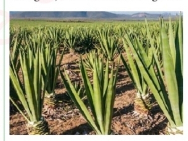
- What is the type of the photograph?
- State the scale of the production
- Outline any four regions in Tanzania where the photograph might have been taken
- What are the three necessary conditions that favour the growth of the crop shown on the photograph above?
- List down any four uses of the crop shown on the photograph
SECTION C (30 MARKS)
Answerany two questions in this section
8. a) An announcement from the ministry concerning with industries directed that, government police may play a great role in determining the location of industries, hence the minister argued that, ‘we discourage the concentration of industries in one place” what are the reasons led a minister to argue so? Four points
b) East Africa is struggling to establish several industries so as to fasten the growth of economy. Thus different types of manufacturing industries have been introduced, as an expert in manufacturing, industries identify groups of manufacturing industries in the region concern. Give six groups with vivid examples
9. Plantation is the most form of agriculture practiced in tropical region of Africa, Asia and South America. Justify six (6) characteristics of plantation practiced in these areas.
10. Explain any six objectives of constructing the striglers gorge of hydro-electric power in Tanzania.
FORM THREE GEOGRAPHY EXAM SERIES 97
FORM THREE GEOGRAPHY EXAM SERIES 97
THE PRESIDENT’S OFFICE
MINISTRY OF EDUCATION, REGIONAL ADMINISTRATION AND LOCAL GOVERNMENT
SECONDARY EXAMINATION SERIES
GEOGRAPHY MID TERM EXAMINATION
FORM THREE- AUG/SEPT -2021
Time: 3Hours
Instructions.
- This paper consists of section A, B and C with a total of 10 questions
- Answer all questions in section A and B and two questions from section C.
- Section A carries 15 marks, section B 55 marks and section C 30 MARKS
- Map extract sheet for Pangani is provided.
- Programmable calculators, cellular phones and any other unauthorized materials are not allowed in examination room.
- Write your number on every page of your answer booklet.
SECTION A (15 Marks)
Answer All questions in this section.
(i) In the field study, students were told that, soil has certain biological, chemical and physical characteristics. What is the general term for these characteristics?
- soil profile
- soil particles
- soil properties
- soil fertility
- soil formation.
(ii)A girl was crossing a river and accidentally dropped her school bag in the river. The girl cried as she observed her bag being pulled by the river water toward the river mouth. What could the bag named in relation to the river action?
- River erosion
- River transportation
- River load
- River meander
- River bed
(iii) Which of the following layers of the earths interior is made up of sima and sial?
- Biosphere
- Hydrosphere
- Asthenosphere
- Lithosphere
- Barysphere
(iv) Suppose you want to carry out a field study on atmospheric conditions suitable for growth of crops cultivated on a farm within your village. What are the best components of weather to be considered?
- Rainfall and soil
- Moisture and sunshine
- Rainfall and clouds cover
- Temperature and rainfall
- Humidity and rainfall
(v)Prediction of the state of atmosphere in a region for 24 to 48 hours is known as
- weather elements
- weather report
- weather instrument
- weather station
- weather forecasting
(vi) The process of changing granite to gneiss rock is known as
- sedimentation
- vulcanism
- denudation
- metamophism
- exfoliation.
(vii)Which of the following are features of ocean floor?
- Basin, Ocean deep and Cliff.
- Trench, Continental shelf and Stump
- Trench, Ridge and Ocean deep.
- Ocean deep, Continental shelf and Drumlin.
- Basin, Continental shelf and Tombolo.
(viii) Liverpool team scored a goal at 5.00 pm in England (15° W). At what time the goal was scored in Dar es Salaam (45° E)?
- 1.00 p.m
- 7.00 p.m
- 9.45 p.m
- 9.00 p.m
- 6.30 a.m.
(ix) Which of the following planets have small celestial bodies in orbit a round them?
- Mercury, Jupiter and Uranus
- Pluto, Earth a nd Mars
- Earth, Jupiter and Saturn
- Mercury, Venus and Earth
- Venus, Earth and Saturn.
(x) Which of the following is associated with magnitude of an earthquake?
- Richter scale
- Seismography
- Focus
- Epicenter
- Tsunami.
2. Match the items in List A with the responses in List B by writing the letter of the correct response beside the item number in the answer booklet provided.
| LIST A | LIST B |
| (i) Residues that have decomposed and mixed with soil mass. (ii) Status of soil with respect to amount of elements necessary for plants growth. (iii) Removal of materials from surface of land. (iv) Vertical section of the soil to the underlying rocks. (v) Fineness and coarseness of soil particles. |
|
SECTION B (55 Marks)
Answer all questions in this section.
3. Study the map extract of Mkomazi (Sheet 109/1) and then answer the following questions:
- By using the given RF scale, measure the distance of river Pangani in kilometres from grid reference 910771 to 910826.
- Describe relief of the area.
- With reasons, identify two types of rocks found in the map.
- Name the major way used to show the height of the land in the mapped area.
- Using a vertical scale of lcm to represent 50m, draw an annotated cross section from grid reference 960820 to 910880 and mark Ruvu river basin and the main trucks.
4. Read carefully the climatic data for station A presented in the Table and answer the questions that follow:
| Month | J | F | M | A | M | J | J | A | S | O | N | D |
| Temp. in °C | 26.6 | 26.6 | 26.6 | 26.6 | 26.6 | 26.6 | 27.2 | 27.7 | 28.3 | 28.3 | 27.7 | 27.7 |
| Rainfall mm | 233 | 228 | 244 | 215 | 118 | 91 | 36 | 36 | 51 | 104 | 140 | 196 |
(i) Describe the climatic conditions of station A.
(ii) Name any two countries in the Great Lakes of East Africa which experience this type of climatic conditions.
(iii) Present the data graphically.
5. (a) Show the features formed by intrusive land forms
(b) With vivid examples, explain what is lava plateau
6. Study carefully the photograph provided, then answer the questions that follow:
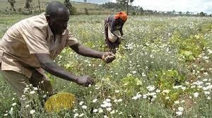
(a) Name the type of photograph provided.
(b) Name the crop shown in the foreground of the photograph.
(c) State the characteristics which favour the growth of the crop in (b) above.
(d) Comment on the stage which might have been reached by the crop mentioned in (b) above.
7. Study the following data showing the age of the Primary School pupils at Tumaini Primary School and answer the questions that follow: 15, 8, 7, 6, 12, 5, 14 and 13.
(i) Determine the range and median of the age of the pupils.
(ii) Calculate the standard deviation.
SECTION C (30 Marks)
Answer two (2) questions from this section.
8. Analyze six potentials of the Rufiji river basin.
9. Elaborate eight reasons indicating why the transportation sector is important to the economy of Tanzania.
10. Explain the main characteristics of nomadic pastoralism in East Africa and suggest the main ways of improving pastoralism in the region.
FORM THREE GEOGRAPHY EXAM SERIES 60
FORM THREE GEOGRAPHY EXAM SERIES 60
THE PRESIDENT'S OFFICE
MINISTRY OF REGIONAL GOVERNMENT AND LOCAL GOVERNMENT
AUGUST-SEPTEMBER EXAMINATION SERIES
GEOGRAPHY FORM-3
2020
TIME: 2:30 HRS
Instructions
- This paper consists of sections A, B and C with a total of ten (10) questions.
- Answer all questions in sections A and B and any two (2) questions from section C.
- Map extract of Mkomazi (Sheet 109/1) is provided.
- Programmable calculators, cellular phones and unauthorised materials are not allowed in the examination room.
- Write your Examination Number on every page of your answer booklet(s).
SECTION A (15 Marks)
Answer all questions in this section.
1. For each of the items (i) — (x), choose the correct answer from among the given alternatives and write its letter besides the item number in the answer booklet provided.
(i) Which of the following layers of the earths interior is made up of sima and sial?
- Biosphere
- Hydrosphere
- Asthenosphere
- Lithosphere
- Barysphere
(ii) You are asked to help a Form Two student who failed to identify the types of forests found in the area with low temperatures. What type of forest will you suggest among the following?
- Tropical rain forest
- Coniferous forest
- Equatorial forest
- Deciduous forest
- Mediterranean forest
(iii) What is the social-economic advantage of reserved forests to societies?
- Tourism
- Lumbering
- Mining
- Forestry
- Agriculture
(iv) Which of the following instrument is used to measure maximum and minimum temperature?
- Barometer
- Thermometer
- Anemometer
- Sixs thermometer
- Hydrometer.
(v) Which among the following is an extrusive volcanic feature?
- Crater
- Laccolith
- Batholith
- Sills
- Dykes.
(vi) A region which consists of thick forests, tree dwellers and people who engage in cultivation of rubber, cocoa, bananas and oil palms is known as
- Tropical savanna
- Tropical monsoon
- Polar climate
- Mediterranean
- Equatorial.
(vii)Which of the following is not a process for chemical weathering?
- Carbonation
- Saltation
- Hydrolysis
- Hydration
- Oxidation.
(vii) Which among the following features are produced by wave erosion?
- A Geo, wave cut platform and stack
- Blow hole, sea arch and levee
- Sea arch, beach and stump
- Beach, spit and bars.
- Tombolo, meander and cliff.
(ix) The process through which rain water enters the ground is called
- Evaporation
- Infiltration
- Transpiration
- Condensation
- Percolation.
(x)The process of peeling off and falling of rock mass is called
- disintegration
- weathering
- mass wasting
- erosion
- exfoliation.
2. Match the process involved in the formation of rocks in with the type of rock in List B by writing the letter of the correct response beside the item number in the answer booklet provided.
| LIST A | LIST B |
|
|
SECTION B (55 Marks)
Answer all questions in this section.
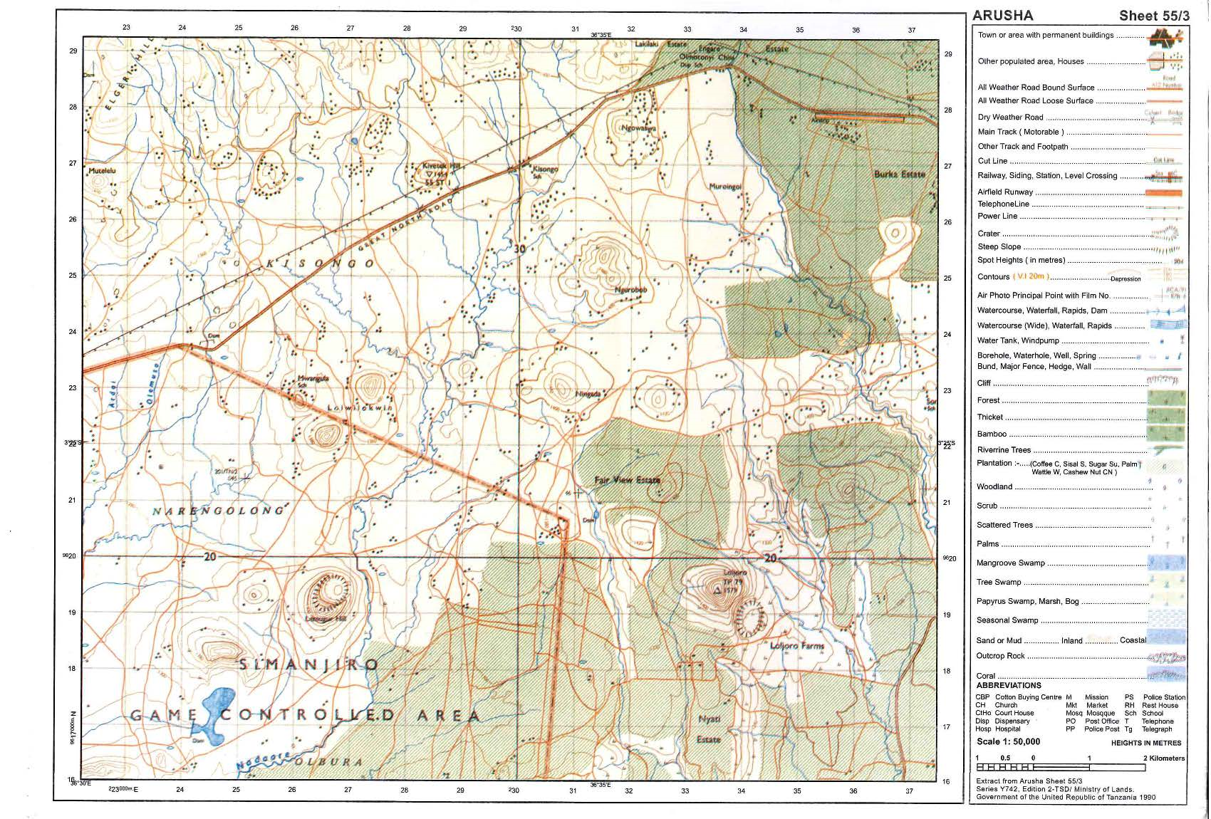
4. Carefully study the map extract of Arusha (Sheet 55/3) provided then answers the questions that follow.
- Describe the relief of the mapped area.
(b) Giving evidences, mention the major means of transport shown in a map.
(c) Change the scale of the map into a statement scale.
(d) Measure the length of the road from grid reference 378314 to grid reference 480276 in kilometres.
(e) With evidence from the map, identify three social services which are found in this area.
 |
5. (a) Define compound bar graph.
(b) Study carefully the table below on hypothetical data about cash crops production (in ‘000 tonnes) in East Africa in the year 2000, then answer the questions that follow. Find this
| Country | Crops |
| |
| Coffee | Tea | Cotton | |
| Kenya | 2200 | 2000 | 1800 |
| Uganda | 1700 | 700 | 800 |
| Tanzania | 1300 | 1900 | 2300 |
(i) Draw compound bar graphs to represent the data provided.
(ii) Outline four merits of using compound bar graph.
5. (a) Explain two major forms of measurements in land surveying.
(b) (i) Define leveling.
(ii) Explain four significances of leveling.
6. (a) What is an earthquake?
(b) Briefly explain five effects of earthquakes.
7. Carefully study the photograph given below then answer the questions that follow:
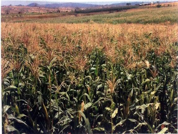
(a) Name the type of photograph.
(b) Describe the relief of the area.
(c) Giving two reasons, describe the scale of production of the crop in the photograph.
(d) Explain two uses of the crop in the photograph.
(e) Describe three conditions necessary for the production of the crop.
SECTION C (30 Marks)
Answer two (2) questions from this section.
8. Give five reasons for decreasing death rates in many parts of the world.
9. Explain eight characteristics of shifting cultivation.
10. Describe six problems facing railway transportation in East Africa.
FORM THREE GEOGRAPHY EXAM SERIES 26
FORM THREE GEOGRAPHY EXAM SERIES 26

DOWNLOAD LEARNING HUB APP NOW

SORRY, YOU CAN'T VIEW THIS MARKING SCHEME PLEASE DOWNLOAD LEARNING HUB APP FROM PLAYSTORE TO GET FULL ACCESS TO ALL MARKING SCHEME!!
Click Here To Download Learning Hub Tanzania App
SAMAHANI, HUWEZI KUFUNGUA MAJIBU YA MTIHANI, TAFADHALI PAKUA APP YA LEARNING HUB TANZANIA ILI KUWEZA KUFUNGUA MAJIBU YA MITIHANI KATIKA TOVUTI HII!!
Bofya Hapa Kupakua App Ya Learning Hub Tanzania
Hub App
 For Call,Sms&WhatsApp: 255769929722 / 255754805256
For Call,Sms&WhatsApp: 255769929722 / 255754805256  MATOKEO YA KIDATO CHA VI 2026
SECONDARY REGIONAL EXAMS
PRIMARY REGIONAL EXAMS
FORM VI NECTA REVIEWS
FORM IV NECTA REVIEWS
FORM II NECTA REVIEWS
STD VII NECTA REVIEWS
STD IV NECTA REVIEWS
SECONDARY EXAMS SERIES
PRIMARY EXAMS SERIES
PRIMARY SUBJECT NOTES
SECONDARY SUBJECT NOTES
SECONDARY TOPICAL EXAMS
SECONDARY TOPICAL QUESTIONS
PRIMARY TOPICAL QUESTIONS
PRACTICAL EXAMS & NOTES
SECONDARY REGIONAL EXAMS
DOWNLOAD SUBJECT NOTES
SCHEMES OF WORK (PRIMARY & SECONDARY)
LESSON PLAN
SECONDARY LOG BOOKS
PRIMARY LOG BOOKS
LITERARY WORKS / UCHAMBUZI VITABU
METHALI ZOTE ZA KISWAHILI
Vitendawili Vya Kiswahili
FORM VI RESULTS 2024
FORM FIVE SELECTION 2024
Matokeo KIDATO CHA II 2024
Matokeo Darasa IV 2024
MATOKEO KIDATO CHA IV 2023
FORM ONE SELECTION 2024
FORM VI RESULTS 2023
Matokeo Darasa IV 2022
MATOKEO YA KIDATO CHA VI 2026
SECONDARY REGIONAL EXAMS
PRIMARY REGIONAL EXAMS
FORM VI NECTA REVIEWS
FORM IV NECTA REVIEWS
FORM II NECTA REVIEWS
STD VII NECTA REVIEWS
STD IV NECTA REVIEWS
SECONDARY EXAMS SERIES
PRIMARY EXAMS SERIES
PRIMARY SUBJECT NOTES
SECONDARY SUBJECT NOTES
SECONDARY TOPICAL EXAMS
SECONDARY TOPICAL QUESTIONS
PRIMARY TOPICAL QUESTIONS
PRACTICAL EXAMS & NOTES
SECONDARY REGIONAL EXAMS
DOWNLOAD SUBJECT NOTES
SCHEMES OF WORK (PRIMARY & SECONDARY)
LESSON PLAN
SECONDARY LOG BOOKS
PRIMARY LOG BOOKS
LITERARY WORKS / UCHAMBUZI VITABU
METHALI ZOTE ZA KISWAHILI
Vitendawili Vya Kiswahili
FORM VI RESULTS 2024
FORM FIVE SELECTION 2024
Matokeo KIDATO CHA II 2024
Matokeo Darasa IV 2024
MATOKEO KIDATO CHA IV 2023
FORM ONE SELECTION 2024
FORM VI RESULTS 2023
Matokeo Darasa IV 2022