

iv

FORM ONE GEOGRAPHY EXAM SERIES 211
FORM ONE GEOGRAPHY EXAM SERIES 211
PRESIDENT OFFICE REGIONAL ADMNISTRATION
AND LOCAL GOVERNMENT
SECONDARY EXAMINATION SERIES
COMPETENCE BASED ASSEMENT
GEOGRAPHY FORM ONE
MID TERM EXAMS-AUG/SEPT – 2024
TIME 2:30 HRS
INSTRUCTIONS
1. This paper consists of sections A, B and C with the total of ten (10) questions
2. Answer ALL questions
3. Section A and C carry fifteen (15) marks each and section B carries seventy (70) marks
4. All writing must be in blue or black ink
5. All writing must be written in the space provided
6. Cellullar phones, calculators and any unauthorized materials are not allowed in assessment room
7. Write your names at the top of every page.
SECTION A (15 marks)
Answer ALL questions
i. The low pressure zone of the equator is known as:-
- Latitude
- ITCZ
- Horse latitudes
- Polar front
ii. The instrument at the weather station which is painted white and is used for storing other weather instruments is known as a
- Barometer
- Wind vane
- Stevenson screen
- Rain gauge.
iii. Which object is found at the center of our solar system?
(A) The Moon
(B) Mars
(C) The Sun
D) An asteroid
iv. Besides the Sun, the largest object in our solar system is:
(A) Earth
(B) Neptune
(C) Jupiter
(D) The Asteroid Belt
v. Striping method is used in finding area for
- Irregular shapes
- Regular shapes
- Both regular and irregular shapes
- Plantation farms.
vi. The term Map refers to:-
- Ratio between the distance on the map and the actual distance on the ground.
- Lines connecting all points of equal height above sea level
- A representation of the earth or part of the earth on a flat surface such as paper or chalk board.
- A direction of one point from another expressed in degree of an angle from north clock wise.
vii. What and air currents do not move in straight lines due to spinning effect of the earth. The term used to describe this situation is?
- Defletion
- Reflection
- Direction
- Deflection
viii. The word "Geography" comes from two Greek words, meaning:
(A) Earth and Study
(B) Earth and Describe
(C) Land and Travel
(D) Land and Map
ix. Which one of the following is not a factor to consider while deciding the climate of a place?
- Prevailing winds
- Annual rainfall
- Distance from the ocean
- Annual range of temperature.
x. The following are factors affecting climate of a place. Which one is not?
- Latitude
- Vegetation
- Soil
- Longitude
2. Match the branch of geography in LIST A with the corresponding meaning in LIST B and write the correct answer on table given.
| LIST A | LIST B |
|
|
SECTION B
3. Answer the following questions per the given instructions:-
- Mention three kinds of rainfall
- ………………………………………………………………
- ………………………………………………………………
- ………………………………………………………………
- Name five weather elements in your locality
- ……………………………………………………………….
- ……………………………………………………………….
- ……………………………………………………………….
- ………………………………………………………………..
………………………………………………………………..
4. Differentiate between the following geographical terms.
a) Aphelion and perihelion
b) Longitude and Latitude.
c) Umbra and penumbra.
d) Lunar and solar eclipse.
5. Explain for (4) reasons to prove that the earth rotates on its own axis.
a) …………………………………………………………………
b) …………………………………………………………………
c) …………………………………………………………………
d) …………………………………………………………………
6.
- Mention three types of scales
- ………………………………………………………………..
- ………………………………………………………………..
- …………………………………………………………………
- Name three types of maps
- ………………………………………………………………….
- ………………………………………………………………….
- ………………………………………………………………….
- Identify three methods used to measure areas of irregular shapes in maps
- …………………………………………………………………….
- …………………………………………………………………….
(iii) …………………………………………………………………….
7. (a) Define revolution of the earth
(b) Mention the effects of earth revolution.
8.(a) Define the term Climate.
(b) What is the difference between climate and weather?
9.List four effects of rotation of the earth on its axis
SECTION C
10. Name and explain five types of mountains
FORM ONE GEOGRAPHY EXAM SERIES 182
FORM ONE GEOGRAPHY EXAM SERIES 182
PRESIDENT'S OFFICE REGIONAL ADMINISTRATION
AND LOCAL GOVERNMENT
SECONDARY EXAMINATION SERIES
COMPETENCE BASED ASSESSMENT
GEOGRAPHY FORM ONE
MID TERM EXAMS-AUG – 2023
TIME 2:30 HRS
INSTRUCTIONS
1. This paper consists of sections A, B and C with the total of ten (10) questions
2. Answer ALL questions
3. Section A and C carry fifteen (15) marks each and section B carries seventy (70) marks
4. All writing must be in blue or black ink
5. All writing must be written in the space provided
6. Cellullar phones, calculators and any unauthorized materials are not allowed in assessment room
7. Write your names at the top of every page.
SECTION A (15 marks)
Answer ALL questions
1. Choose the correct answer from the following multiple choices
i. Drawing a map based on distribution of natural features in Tanzania. This activity is based on what branch of Geography?
a) Physical geography
b) Practical geography
c)Regional geography
d) Human and economic geography
Ii. Form one students were discussing about the chronological arrangement of planets in the solar system which among the following is the largest planet?
a) Jupiter b) Uranus
c) Saturn d) Pluto
iii. Why are the planets not colliding one another as they revolve the sun?
a) Because each planet has it own moon
b) All planets have satellites
c) Because each planet has it own path called orbirt
d) Because all planets revolve around the sun on the same orbit
iv. Last session in Geography club, Kamla and Rohan were studying about the Earth.
Which of the following is true regarding the Earth as they were discussed?
a) It is the third largest planet in the solar system
b) It is the only planet that is known to support life.
c) It has average temperature that crosses the orbits of other planets
d) It revolve around the sun once in every 364 days
v. When the moon shadow is cast over the earth’s the phenomena is called:-
a) Lunar eclipse b) Solar eclipse
c) Equinox d) Summer solistice
vi. Which of the following is evidence that the Earth is a spherical ?
a) The ship comes from far away
b) The ship sails on the surface of a round Earth
c) The Earth revolves around the sun
d) The ship’s visibility in the ocean changes with distance
vii. Equal length of day and night when the sun is overhead at the equator is known as :-
a) Solstice b) Aphelion
c) Cars d) Periphelion
viii. From the following pairs of mountains which one represent fold mountains:
a) Himalaya and Usambara
b) Atlas and Alps
c) Uluguru and Usambara
d) Kilimanjaro and Vesuvius
ix. The decrease of temperature with the increase of altitude is known as:
a) Temperature inversion b) latitudional
c) Isotherms d) Lapse rate
x. If the minimum and maximum temperature recorded in Dar-es-salaam on May 23rd 2019 were 23.5? and 32.5? respectively. Calculate the mean daily temperature of Dar-es-salaam.
a) 56? b) 9.0?
c) -9.0? d) 28?
| i | ii | iii | iv | v | vi | vii | viii | ix | x |
|
|
|
|
|
|
|
|
|
|
|
2. Match each term from List B with correct meaning in List A
| LIST A | LIST B |
| ||||
| i) The planet called boiling planet due to its closeness to the sun ii) The only planet which support the life iii) The hottest planet which has high amount of greenhouse gases in its atmosphere. iv) Its atmosphere is mainly composed of carbon dioxide and has two natural v)The planet that has a ring system which act as its distinctive feature | a) Jupiter b) Saturn c)Mars d)Earth e) Mercury f)Venus g) Uranus |
| ||||
| i | ii | iii | iv | v | ||
|
|
|
|
|
| ||
|
|
|
|
|
|
|
|
SECTION B (70 marks)
Answer ALL questions
3. a i) An eclipse is a total or partial obstruction of light from the sun by either the earth or the moon. How does it occurs?
____________________________________________________________________________________ ____________________________________________________________________________________
ii) What type of eclipse will occur when the moon is between the Sun and Earth and its shadow fails on the Earth’s surface?
____________________________________________________________________________________ ____________________________________________________________________________________
b) Is it possible for a solar or lunar eclipse to happen every month? Explain your answer. ____________________________________________________________________________________ ____________________________________________________________________________________ ____________________________________________________________________________________
____________________________________________________________________________________
4. As a Geographer suppose that you have been invited by the villagers of
Songambele village to teach them about the major features found on the Earth’s surface.
a) Identify four features that may be found in Songambele village.
i) ___________________________________________________________________________________
ii) __________________________________________________________________________________
iii) __________________________________________________________________________________
iv) _________________________________________________________________________________
b) Mention four types of the feature of the Earth’s surface that rises abruptly to a graeter height usually above 300 meters from a surrounding level.
i) ___________________________________________________________________________________
ii) __________________________________________________________________________________
iii) __________________________________________________________________________________
iv) _________________________________________________________________________________
c) Identify two benefits of that features mentioned above in (a).
i) ___________________________________________________________________________________
ii) __________________________________________________________________________________
5. a) In Mtakuja villages people have been engaged into different activities. What are the five possible human activities that may be conducted in Mtakuja village.
i) ___________________________________________________________________________________
ii) __________________________________________________________________________________
iii) __________________________________________________________________________________ iv)__________________________________________________________________________________
v) __________________________________________________________________________________
6(a) Asiatu and Sweke wanted to drop Geography subject because they think that it is useless. As a Geographer tell them the benefit of studying Geography.
i) ___________________________________________________________________________________
ii) __________________________________________________________________________________ iii)__________________________________________________________________________________ iv)__________________________________________________________________________________ v)__________________________________________________________________________________
d) Geography describes how human beings interact with the environment. Identify two components of environment and explain each component
i)___________________________________________________________________________________ ____________________________________________________________________________________ ii)___________________________________________________________________________________ ____________________________________________________________________________________
d)(i) Geography as a subject has three main branches, mention them
i)___________________________________________________________________________________ ii)___________________________________________________________________________________
iii)__________________________________________________________________________________
7. a) Briefly explain on the meaning of the term Weather station
____________________________________________________________________________________ ____________________________________________________________________________________ ____________________________________________________________________________________ ____________________________________________________________________________________
b) Outline four conditions necessary for establishing weather station.
i)___________________________________________________________________________________ ____________________________________________________________________________________
ii)___________________________________________________________________________________
____________________________________________________________________________________ iii)__________________________________________________________________________________ ____________________________________________________________________________________
iv) _________________________________________________________________________________ ____________________________________________________________________________________
c) Amount of sunshine in the sky is determined by the presence or absence clouds.
Outline the importance of sun shine (five points)
i) ___________________________________________________________________________________ ii)___________________________________________________________________________________
iii) __________________________________________________________________________________
iv) _________________________________________________________________________________
v) __________________________________________________________________________________
8. a) Both latitude and longitudes are used to locate position on a map. Identify their differences
____________________________________________________________________________________ ____________________________________________________________________________________ ____________________________________________________________________________________
b) Mention three importance of latitudes and longitudes
i) __________________________________________________________________________________
ii) __________________________________________________________________________________
iii) __________________________________________________________________________________
c)What is the longitude of Lindi whose local time is 8:24pm when the local time of Montevideo (Uruguay) 56°W is 2:00pm?
____________________________________________________________________________________ ____________________________________________________________________________________ ____________________________________________________________________________________ ____________________________________________________________________________________ ____________________________________________________________________________________ ____________________________________________________________________________________ ____________________________________________________________________________________ ____________________________________________________________________________________ ____________________________________________________________________________________ ____________________________________________________________________________________
____________________________________________________________________________________
9.a) A map is good if it contain all the essential of map. Identify five essentials of a good map and their functions.
i) __________________________________________________________________________________ ii) __________________________________________________________________________________ iii) __________________________________________________________________________________ iv) __________________________________________________________________________________ v) __________________________________________________________________________________
b) Identify procedures used to locate position on a map by using a compass bearing
i)___________________________________________________________________________________ ii)___________________________________________________________________________________
iii) __________________________________________________________________________________
c)Different features on a map may appear either in regular or irregular shapes. Mention three methods of determining areas of irregular shapes on a map.
i) __________________________________________________________________________________
ii) __________________________________________________________________________________
iii) __________________________________________________________________________________ SECTION C (15 MARKS)
Answer question number ten (10)
10. Carefully study the climatic data for station X and then answer the given questions
| Months | J | F | M | A | M | J | J | A | S | O | N | D |
| Temp ? | 23 | 24 | 24 | 24 | 24 | 24 | 26 | 26 | 27 | 26 | 26 | 24 |
| Rainfall mm | 338 | 200 | 433 | 355 | 275 | 230 | 160 | 70 | 50 | 25 | 15 | 230 |
a) Calculate the annual range of temperature
____________________________________________________________________________________
____________________________________________________________________________________ ____________________________________________________________________________________
b) Calculate the total rainfall
____________________________________________________________________________________
____________________________________________________________________________________ ____________________________________________________________________________________
c)With two evidences, suggest the type of climate for station X
____________________________________________________________________________________
____________________________________________________________________________________
____________________________________________________________________________________
c) What are the major economic activities that conducted in that area.
I) __________________________________________________________________________________
II) __________________________________________________________________________________
III) _________________________________________________________________________________
FORM ONE GEOGRAPHY EXAM SERIES 145
FORM ONE GEOGRAPHY EXAM SERIES 145
THE PRESIDENT’S OFFICE
REGIONAL ADMINISTRATIVE AND LOCAL GOVERNMENT
FORM ONE EXAMINATIONS SEPTEMBER 2022
GEOGRAPHY
TIME: 2:30 Hours
![]()
Instructions
- This paper consists of section A, B and C with a total often (10) questions.
- Answer all questions in section A and B and section C.
- All writing must be in blue of black ink.
- All answers must be written in the space provided.
- Cellular phones, calculator and any unauthorized materials are not allowed in the examination room.
- Write your examination number at the top right corner of every page.
SECTION A (15 MARKS)
Answer all questions in this section.
1. For each of the items (i) — (x), choose the correct answer from among the given alternative and write its letter in the box provided.
- The Earth's shape is flattered sphere which is called;
- Geodic
- Globe
- Galaxy
- Spheroid
- Cyclic
- Mr Maurice and his colleagues enjoyed the temperature of Mtwara which was 32°C at sea level.
They had a plan to travel to visit Babati for their vacation which is 1500m above the sea level. What will be the temperature they expect to experience during their visit in Babati?
- 23°C
- 41°C
- 0.6°C
- 9 °C
- 20°C
- Which of the following planets is closest to the sun?
- Earth
- Jupiter
- mars
- Mercury
- Neptune
- when the moon’s shadow casts over the earth’s surface the phenomenon is known as
- Lunar eclipse
- Solar eclipse
- Equinoxes
- Summer solstice
- Winter solstice
- The Earth have different evidences that proves that the Earth is spherical. What do you think that this is one among those evidences?
- The four seasons
- The lunar eclipse
- The revolution of the Earth
- The Earth rotation
- The eclipse of the sun
- If the scale of a map is 1: 50,000 what will be the actual ground distance of a river with 18cm on a map?
- 9km
- 2km
- 18000km
- 4Km
- 900,000 km
- If the temperature at 950 metres is 240 C What is the temperature of Kilimanjaro 5895 metres above the sea level?
- 10.240 C
- 340 C
- 5.670 C
- 18.50 C
- 320 C
- The following are the element of weather
- Soils, clouds, dew, humidity, rainfall
- Pressure, clouds, sunshine, humidity, winds
- Fog, barometer, humidity, pressure, air mass
- Pressure, humidity, soil, fog, rainfall
- Clouds, sunshine, pressure, humidity, thermometer
- Assume you have given a task to identify the proper arrangement of the first five planets of the solar system according to the distance from the sun starting with the nearest planet. Which one of the following set will be the best set of arrangement of the first five planets of the solar system?
- Mercury, Earth, Venus, Saturn, and Mars
- Mercury, Venus, Earth, Mars and Jupiter
- Venus, Mercury, Mars, earth and Venus
- Mars, Earth, Mercury, Jupiter and Venus
- Mercury, Jupiter, Earth, Venus and Uranus
- Taifa Stars scored a goal against Malawi in Town Y 150E at 4:00 pm. At what time will commentator at Town X 630W will communicate a goal?
- 4:47 pm
- 10:48 am
- 11:12 am
- 1:48 pm
- 6:12 pm
2. Match the descriptions of bodies in the solar system in List A with the correct solar system body in List B by writing the letter of the correct response below the corresponding item number in the table provided.
| List A | List B |
|
|
SECTION B (70 MARKS)
Answer All Questions from this section
3. The students were watching a video program showing the earth's surface in Tanzania which was irregular. Difference in altitudes and slope give rise to different features and human activities observed in the video program.
(a) Outline five possible features observed by the students.
(b) By giving an example, mention major types of water bodies observed.
(c) Give an example of the main natural basin on the earth's surface observed by the students in the video program
(d) Name four possible types of a large and elevated part of the earth's surface that rise from greater height the students observed.
4. (a) Giving one example, briefly explain four main categories of mountain.
(i) …………… …………… …………… ……………
(ii) ……………… ……………… ………………
(iii) …………… ……………… ……………… ………………
(iv) ……………… ……………… ……………… ………………
(b) (i) Briefly explain the formation of rift valleys.
(ii) List five rift valley lakes in East Africa.
5. Study the sketch map provided and answer the questions that follow:
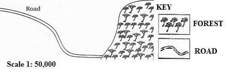
- Name the type of scale which has been used to represent this map.
- Mention three ways which can be used to measure the distance of the road in the sketch map.
- Briefly describe three important basic components of a map.
- Convert the given scale into a statement.
- Mention three methods which can be used to calculate the area of the forest shown on the sketched map.
6.(a) Outline five evidences to verify that the Earth is spherical.
![]() (b) Briefly describe the following features of the continents
(b) Briefly describe the following features of the continents
(i)Basin
(ii)Plateau
(iii)Valley
7. (a) Outline four ways of determining direction of a place on a map.
(b) List four features of the Representative Fraction (RF) scale.
(c) Suggest two ways of measuring areas with irregular shapes.
8. (a) What are the values of scale to the map users? Gives three
- Which methods can be used to locate position of a place on the map? Mention four.
- The distance of the road from Ifakara to Mang’ula is 38 cm. convert the distance in kilometer if the scale used is 1:50000.
- Why do you study maps? Give two reasons
- A large scale, medium scale and small scale maps all are the types of map scale.
With examples explain how they are distinguished by one to another. Give two reasons.
9. (a) Distinguish the following terms:
- Solar system and solar energy
- Raw materials and manufacturing industries
- Map and scale of a map
- Plateau and mountain
(b)
- Define lunar eclipse.
- Draw a well labelled diagram to show lunar eclipse.
SECTION B (15 MARKS)
Answer Question 10
10. (a) Carefully study the climatic data given for station X and then answer the questions that follow:
| Month | J | F | M | A | M | J | J | A | S | O | N | D |
| Temp °C | 30 | 30 | 30 | 31 | 32 | 38 | 37 | 37 | 35 | 34 | 31 | 30 |
| RAINFALL (mm) | 10 | 20 | 26 | 15 | 8 | 0 | 0 | 0 | 12 | 18 | 15 | 10 |
(i) Calculate the annual mean of temperature.
(ii) Determine the annual rainfall.
(iii) Calculate the mean range of temperature.
(iv) What type of climate does station X experience? Give reasons.
(v) Suggest the hemisphere in which station X is located.
(b) (i) Define:
a map
a scale
(ii) List down four essentials of a map.
(iii) In station P on a map, an area covered by thick forest was found to be 12 full squares and 26 half squares. Calculate the area of the thick forest in square kilometres.
(iv) If the map distance of Ruvu river is 29 centimetres, calculate actual distance of Ruvu river in kilometres given that the map scale is 1:25,000.
(v) Change the scale 1:25,000 into a statement scale.
FORM ONE GEOGRAPHY EXAM SERIES 102
FORM ONE GEOGRAPHY EXAM SERIES 102
THE PRESIDENT’S OFFICE
MINISTRY OF EDUCATION, REGIONAL ADMINISTRATION AND LOCAL GOVERNMENT
SECONDARY EXAMINATION SERIES
GEOGRAPHY MID TERM EXAMINATION
FORM ONE-AUG/SEPT-2021
Time: 2:30Hours
Instructions.
- This paper consists of section A, B and C with a total of 10 questions
- Answer all questions in section A and B and TWO questions from section C.
- Section A carries 25 marks, section B 45 marks and section C 30 Marks
- All answers should be written in the spaces provided.
- All communication devices, calculators and any unauthorized material are not allowed in examination room.
- Write your number on every page of your answer booklet.
SECTION A (35 Marks)
Answer All questions in this section.
i) A raised part of an ocean is called;
- A ridge
- Ocean deeps
- Continental shelf
- Deep sea plains
ii) Which of the following is a fold mountain?
- Ruwenzori
- Mt. Kilimanjaro
- Mt. Usambara
- Mt. Evarest.
iii) Which of the following is an example of an extinct volcano?
- Mt. Elgon
- Mt. longonot
- Black forest mountains
- Mt. Sinai.
(iv) Geomorphology is regarded as;
- The study of soil science
- The study of Geology
- The study of physical features
- The study of flora and fauna.
(v) Geography is sub – divided into;
- Practical, Human, Economic.
- Physical, Practical, Demography
- Human – economic, practical and physical.
- Practical, Survey, Statistics.
(vi) Agriculture, mining, lumbering can be studied in:
- Physical Geography.
- Human and economic Geography.
- Plant Geography.
- Practical and physical Geography.
(vii) If the local time at place A (30 0 N, 30 0 E) is 8.00 a.m., what will be the local time at place B (27 O N, 12 0 E)? ![]()
A. 6.28 a.m.
B. 6.28 p.m.
C. 9.32 a.m.
D. 9.32 p.m. ![]()
(viii) Block mountains are formed through:
- earthquakes
- faulting
- folding
- vulcanicity
(ix) Crater lakes are most likely to be formed in
- areas of fold mountains
- intensively faulted areas
- downwarped areas
- regions where subsidence is taking place
- areas of active vulcanicity.
(x)Which of the following pairs is not a correct association?
- Isobar and pressure
- Isobar and sunshine
- Isotherms and temperature
- Isohyets and rainfall
2. Match the items from list A with those in list B.
| LIST A | LIST B |
| (i) Survey (ii) Climatology (iii) Practical geography (iv) Geomorphology (v) Pedology |
|
3. In each of the following items (i – x), write TRUE if the statement is correct or FALSE if the statement is not correct.
(i)Ocean trenches are also known as submarine plateaus ....
(ii)Equator is not the Great Circle ...
(iii)An eclipse is described as partial when only a part of heavenly body is obscured .........
(iv)Maximum thermometer records both maximum temperature with a day........
(v)Grid reference and bearing are used to determine the position of a place on a map ....
(vi)A scale helps map interpreters to calculate distance, area and computation of other facts....
(vii)Ocean currents are set in motion by prevailing winds .........
(viii)Juvenile water is also referred as underground water .........
(ix)Circumnavigation of the earth is not among the evidence to prove that the earth is spherical......
(x) Geography is originated from Greek words Geo and Graphien_______
SECTION B (45 Marks)
Answer all questions in this section.
4.(a) Outline five evidences to verify that the Earth is spherical.
(b) Differentiate the following terms:
![]() (i) Meteors and satellites
(i) Meteors and satellites
(ii) Sea and lake
5.(a) Mention five features of the ocean floor.
(b) Name the five largest oceans in the world.
(c) Mention five largest lakes in the world.
(d) Differentiate the following terms:
(i)Temperature and humidity
(ii)Minimum and maximum thermometer
(iii) Pressure and wind
6. (a) Mention three ways of locating places on maps.
(b) Name three methods used to measure distance of linear features on a ![]() map.
map.
SECTION C (30 Marks)
Answer two (2) questions from this section.
7. (a) Distinguish the following terms:
- Solar system and solar energy
- Raw materials and manufacturing industries
- Map and scale of a map
- Plateau and mountain
(b)
- Define lunar eclipse.
- Draw a well labelled diagram to show lunar eclipse.
8. Carefully study the climatic data given for station X and then answer the questions that follow:
| Month | J | F | M | A | M | J | J | A | S | O | N | D |
| Temp °C | 30 | 30 | 30 | 31 | 32 | 38 | 37 | 37 | 35 | 34 | 31 | 30 |
| RAINFALL (mm) | 10 | 20 | 26 | 15 | 8 | 0 | 0 | 0 | 12 | 18 | 15 | 10 |
(i) Calculate the annual range of temperature.
(ii) Determine the annual rainfall.
(iii) Calculate the mean annual temperature.
(iv) What type of climate does station X experience? Give reasons.
(v) Suggest the hemisphere in which station X is located.
9. (a) Study the map provided then answer the questions that follow:
|
Scale: 10m to 0.5km |
(i) Calculate the area of the mine.
(ii) Find the bearing of point B from A.
(iii) Give the direction of A from B.
(iv) State the grid reference of A and B.
(b) Carefully study the climatic graph given and then answer the questions that follow.
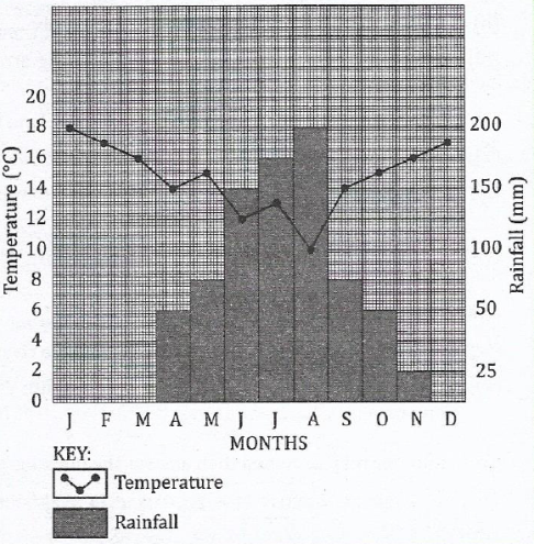
|
|
(i) Calculate the annual range of temperature.
(ii) Calculate the annual rainfall for the station.
(iii)Calculate the mean annual rainfall for the station.
(iv)Suggest the type of climate for the station.
(v) Give reasons for the suggestion you have given in (iv) above.
10. Describe the factors that influence the climate of a place
FORM ONE GEOGRAPHY EXAM SERIES 66
FORM ONE GEOGRAPHY EXAM SERIES 66
THE PRESIDENT'S OFFICE
MINISTRY OF REGIONAL GOVERNMENT AND LOCAL GOVERNMENT
AUGUST-SEPTEMBER EXAMINATION SERIES
GEOGRAPHY FORM-1
2020
TIME: 2:30 HRS
INSTRUCTIONS.
- This paper consists of sections A, B and C with a total of ten (10) questions.
- Answer all questions in section A and B and two (2) questions from section C
- All writing must be in blue or black ink.
- All answers must be written in the space provided.
- Calculators, cellular phones and any unauthorized materials are not allowed in the examination room.
- Write your Examination Number at the top right corner of every page.
SECTION A (25 Marks)
Answer all questions in this section.
1. For each of the items (i) – (ii), choose the correct answer from among the given alternatives and write its letter in the box provided.
(i) One characteristics of equatorial climate is:-
- Low rainfall
- Moderate temperature
- Low humidity
- Thick forest.
(ii) Cultivation of cash crops based on application of advanced technology is called?
- Subsistence agriculture
- A large scale agriculture
- Mixed system agriculture
- A small scale agriculture
(iii)Which one of the following instrument is not the component of a weather station?
- Rain gauge
- Wind vane
- Microscope
- Stevenson screen
(iv)Which type of climate among the following is different from the other?
- Mediterranean
- Savanna
- Hot desert
- Equatorial
(v)The height above the sea level is called:
- Altitude
- Contour
- Latitude
- Ocean
(vi)All meridians pass through:
- the North and South Poles
- the East and West poles
- the Latitudes and Longitudes
- the Greenwich meridian
(vii)The process whereby water vapour is turned into water droplets is called:
- evaporation
- condensation
- saturation
- transpiration
(viii)A feature formed as a result of either natural or artificial depression varying in size on the earth surface is called:
- Island arc
- Fold mountain
- Rift valley
- Basin
(ix)A feature formed as a result of either natural or artificial depression varying in size on the earth surface is called:
- Island arc
- Fold mountain
- Rift valley
- Basin
(x) Contours are lines drawn on maps to join places with the same:
- height between mountains
- altitude above sea level
- areas between valleys
- features in mountains.
2. Match the items in List A with the responses in List B by writing the letter of the correct response below the corresponding item number in the table provided.
| List A | List B |
| (i) Moons of the planets. (ii) Pieces of hard matter falling from outer space. (iii) Natural satellites of the earth (iv) The centre of the solar system. (v) Heavenly body that posses and transmit its own light. |
|
3. Write TRUE for the correct statement and FALSE for the incorrect statement.
- The Earth’s orbit is more spherical than elliptical in shape
- The moon generates light during the night
- Geography deals with Earth’s features only
- Mercury is the largest planet in the solar system
- Equator is the line which divides the earth into two equal hemispheres
- The solar system contains the sun and its planets which revolve around the sun in elliptical orbits.
- The Greet word “Geo” in the concept of Geography refers to: draw, write about or describe the earth.
- The term geography can be defined as the study of the earth as a home of man and other living organisms.
- Physical geography is concerned with field study, photography work, map work and statistics.
- One of the importance of studying geography is to understand the social and geographical problems and how to solve them.
SECTION B (45 Marks)
Answer all questions in this section.
4.(a) Mention five sources of water in Tanzania.
(b) Mention five uses of water.
(c) Briefly describe the following terms:
(i)Hydrological cycle
(ii)Water conservation
(iii)Water population
5.(a) Outline five evidences to verify that the Earth is spherical.
![]() (b) Differentiate the following terms:
(b) Differentiate the following terms:
![]() (i) Meteors and satellites
(i) Meteors and satellites
(ii) Sea and lake
6.(a) Outline four ways of determining direction of a place on a map.
(b) List four features of the Representative Fraction (RF) scale.
(c) Suggest two ways of measuring areas with irregular shapes.
7.(a) Mention five features of the ocean floor.
(b) Name the five largest oceans in the world.
(c) Mention five largest lakes in the world.
(d) Differentiate the following terms:
(i)Temperature and humidity
(ii)Minimum and maximum thermometer
(iii) Pressure and wind
8.(a) Convert:
(i)1:50,000 into statement scale.
(ii)lcm to 4.57km into representative fraction scale.
(iii)If the map distance of a certain river on a topographical map is 15 centimeters, calculate the actual ground distance of that river in kilometers given that the map scale is 1:50,000.
(b) (i) Give a difference between Sketch maps and Atlas maps.
(ii) Give three types of northings.
(iii) Name two types of grid reference systems.
9. (a) Distinguish the following terms:
- Solar system and solar energy
- Raw materials and manufacturing industries
- Map and scale of a map
- Plateau and mountain
(b)
- Define lunar eclipse.
- Draw a well labelled diagram to show lunar eclipse.
10. (a) Giving one example, briefly explain four main categories of mountain.
(i) …………… …………… …………… ……………
(ii) ……………… ……………… ………………
(iii) …………… ……………… ……………… ………………
(iv) ……………… ……………… ……………… ………………
(b) (i) Briefly explain the formation of rift valleys.
(ii) List five rift valley lakes in East Africa.
FORM ONE GEOGRAPHY EXAM SERIES 20
FORM ONE GEOGRAPHY EXAM SERIES 20

DOWNLOAD LEARNING HUB APP NOW

SORRY, YOU CAN'T VIEW THIS MARKING SCHEME PLEASE DOWNLOAD LEARNING HUB APP FROM PLAYSTORE TO GET FULL ACCESS TO ALL MARKING SCHEME!!
Click Here To Download Learning Hub Tanzania App
SAMAHANI, HUWEZI KUFUNGUA MAJIBU YA MTIHANI, TAFADHALI PAKUA APP YA LEARNING HUB TANZANIA ILI KUWEZA KUFUNGUA MAJIBU YA MITIHANI KATIKA TOVUTI HII!!
Bofya Hapa Kupakua App Ya Learning Hub Tanzania
Hub App
 For Call,Sms&WhatsApp: 255769929722 / 255754805256
For Call,Sms&WhatsApp: 255769929722 / 255754805256  Matokeo Darasa VII 2025
Matokeo KIDATO CHA II 2024
Matokeo Darasa IV 2024
SECONDARY REGIONAL EXAMS
PRIMARY REGIONAL EXAMS
FORM VI NECTA REVIEWS
FORM IV NECTA REVIEWS
FORM II NECTA REVIEWS
STD VII NECTA REVIEWS
STD IV NECTA REVIEWS
SECONDARY EXAMS SERIES
PRIMARY EXAMS SERIES
PRIMARY SUBJECT NOTES
SECONDARY SUBJECT NOTES
SECONDARY TOPICAL EXAMS
SECONDARY TOPICAL QUESTIONS
PRIMARY TOPICAL QUESTIONS
PRACTICAL EXAMS & NOTES
SECONDARY REGIONAL EXAMS
DOWNLOAD SUBJECT NOTES
SCHEMES OF WORK (PRIMARY & SECONDARY)
LESSON PLAN
SECONDARY LOG BOOKS
PRIMARY LOG BOOKS
LITERARY WORKS / UCHAMBUZI VITABU
METHALI ZOTE ZA KISWAHILI
Vitendawili Vya Kiswahili
FORM VI RESULTS 2024
FORM FIVE SELECTION 2024
MATOKEO KIDATO CHA IV 2023
FORM ONE SELECTION 2024
FORM VI RESULTS 2023
Matokeo Darasa IV 2022
Matokeo Darasa VII 2025
Matokeo KIDATO CHA II 2024
Matokeo Darasa IV 2024
SECONDARY REGIONAL EXAMS
PRIMARY REGIONAL EXAMS
FORM VI NECTA REVIEWS
FORM IV NECTA REVIEWS
FORM II NECTA REVIEWS
STD VII NECTA REVIEWS
STD IV NECTA REVIEWS
SECONDARY EXAMS SERIES
PRIMARY EXAMS SERIES
PRIMARY SUBJECT NOTES
SECONDARY SUBJECT NOTES
SECONDARY TOPICAL EXAMS
SECONDARY TOPICAL QUESTIONS
PRIMARY TOPICAL QUESTIONS
PRACTICAL EXAMS & NOTES
SECONDARY REGIONAL EXAMS
DOWNLOAD SUBJECT NOTES
SCHEMES OF WORK (PRIMARY & SECONDARY)
LESSON PLAN
SECONDARY LOG BOOKS
PRIMARY LOG BOOKS
LITERARY WORKS / UCHAMBUZI VITABU
METHALI ZOTE ZA KISWAHILI
Vitendawili Vya Kiswahili
FORM VI RESULTS 2024
FORM FIVE SELECTION 2024
MATOKEO KIDATO CHA IV 2023
FORM ONE SELECTION 2024
FORM VI RESULTS 2023
Matokeo Darasa IV 2022


