PRIME MINISTER’S OFFICE REGIONAL ADMINISTRATION AND LOCAL GOVERNMENT
FORM FOUR MIDTERM EXAMINATION
013 GEOGRAPHY
Time: 2:30 Hours March, 2026
Instructions
- This paper consists of sections A, Band C with a total of ten (11) questions.
- Answer all questions in section A and B and two (2) questions from section C.
- Map extract of SIKONGE (sheet 137/2) is provided.
- Programmable calculators, Cellular phones and any unauthorized materials are not allowed in the examination room.
- Write your Examination number on every page of your answer booklet (s).
SECTION A (16 MARKS)
Answer all questions in this section
1. For each of the items (i-x), choose the correct answer among the given alternatives and write its letter in the answer booklet (s) provided.
(i) It is a fact that ocean currents are set in motion, one among the reason for the movement of ocean current is
- Revolution
- Lunar eclipse
- Rotation of the earth
- Climatic change
- Volcanism.
(ii) Mr. Kasimba is keeping a group of animals in a permanent place, he does not move from place to place with his animals looking for pasture. What is the general term for the livestock keeping category Mr. Kasimba is practicing?
- Nomadic pastoralism
- Semi nomadic
- Transhumance
- Sedentary livestock keeping
- Commercial animal
(iii) An area of low pressure with high temperature is called?
- Doldrums
- Depression
- Cyclone
- Mountain region
- Equator.
(iv) An overhead sun occurs on the tropic of cancer at?
- 21st June
- 21st March
- 22nd December
- 23rd September
- 23rd June
(v) What will be the temperature of Bagamoyo 500m above the sea level, if the temperature of Same 1500m above the sea level is 150C?
- 24oC
- 25oC
- 26oC
- 26oC
- 21oC
(vi) Absence of drainage on the surface of the limestone region is the direct consequences of……..
- Presence of deep gorges
- Well jointed rocks
- Very low rain in the area
- Big river that swallow small water
- Absence of springs
(vii) People of Mtakuja village are not served by electricity; instead they are using the energy that are produced by inorganic materials (Plants and animals products) after broken down by bacteria in an oxygen free environment. What is the name of such energy?
- Biogas
- Solar energy
- Wind energy
- hydroelectric power
- Sun
(viii) Large masses of volcanic rocks often form the root of the fold mountains are called
- Sill
- Laccolith
- Volcanic cone
- Batholith
- Dyke.
(ix) The chairman of Sanya station village insisted his villagers that they should not enter in the reserved forest of the village. What do you think are the social – economic advantages of the reserved forest?
- Agriculture
- Mining
- Lumbering
- Forestry
- Tourism
(x) The geological time scale is the scheme of scale classified into three eras which one is correct sequence?
- Mesozoic, Paleozoic and Cenozoic
- Period, epoch and ages
- Paleozoic, Mesozoic and Cenozoic
- Cenozoic, Mesozoicand Paleozoic
- Tertiary, quaternary and Oligocene
2. Match the types rocks in list A with their corresponding explanation inlist B by writing the letter of the correct response beside the item number in the answer sheetprovided
| LIST A | LIST B |
|
|
SECTION B (54 Marks)
Answer all questions in this section.
3. Carefully study the Map Extract of SIKONGE (Sheet 137/2) provided, then answer questions that follow below:
(a) With supportive reason, identify thedominant type of rock found on the mapped area.
(b) With vivid evidences from the map, give three main human activities that are taking place on the mapped area.
(c) By using linear scale from the map, calculate the distance of Dry weather road from grid reference 738828 to 759882.
(d) Give the name of the method of showing relief which is found at grid reference 796849.
4. (a) Madam Rose recorded the outcome of his student’s performance in Geography weekly test as follows: 8, 22, 18, 16, 8, 4, 18, 10, 15, 16, 20, 16, 21, 4, 18, 13, 22, 12, 30, 23, 10, 20, 15, 6, 16, 8, and 2. Can you help Madam to find the following?
(i) Mean (iii) Median (ii) Mode (iv)Range
(b) With three points, show the application of the statistical data in daily life at (a) above.
5. Lilian is working in women affairs institution. She decided to conduct a research on the effects of abortion on academic performance for girl students in Katavi Region. She selected only five schools to represent others and then ten girl students were chosen from each school to be used as samples under study.
- What will be the best research approach for her study?
- Name the sampling technique used by Lilian.
- Give two reasons for why Lilian decided to use sample in her research?
- State two uses of her research output.
- Suggest three constraints which possibly faced her collecting date.
6. If you are given a task to conduct a chain survey around your school compound.
(a) What are the main three procedures you would use to carry out the task?
(b) Name three marking instruments which you would use.
7. Study the following photograph and answer the questions that follow:
 |
- Name the crop shown on the photograph.
- What is the activity taking place on the photograph?
- With one evidence, suggest the scale of production of the crop shown.
- List down two conditions necessary for the growth of the crop shown on the photograph.
- Outline two factors that might affect the quality of the photograph given.
8. It is a geographical phenomenon that results to sudden shaking of the Earth and it causes some impacts to the population in the affected area.
- What is the phenomenon spoken about?
- Explain four impacts which might be caused by the geographical event named in (a) above.
- Suggest three precautionary measures to minimize the incidence of the phenomenon named in (a) above.
SECTION C (30 MARKS)
Answer two (02) questions from this section
9. The Minister of national resources and Tourism in Tanzania has been so much active inpromoting tourism sector. Despite the economic significance of the sector, there arenegative impacts to our country. Elaborate this statement by giving (six points).
10. In a Form three classroom, a Geography teacher stated that, “areas affected by vulcanism are not that bad”. Support teacher’s statement in six points.
11. “People do not live everywhere’’ Why? Give six reasons.
FORM FOUR GEOGRAPHY EXAM SERIES 233
FORM FOUR GEOGRAPHY EXAM SERIES 233
THE OFFICE OF THE PRESIDENT, REGIONAL ADMINISTRATION AND LOCAL GOVERNMENT.
SECONDARY EXAMINATION SERIES
MARCH 2025
GEOGRAPHY FORM FOUR
TIME: 2:30HRS
INSTRUCTIONS
1. This paper consists of three section A, B and C with a total of eleven (11) questions.
2. Answer all questions from section A and B and two questions from section C.
3. Section A carries sixteen (16) marks, section B carries fifty four (54) marks and section C carries thirty (30) marks.
4. Map extract of LIWALE sheet 280/4 is provided.
5. All writing should be in blue ink except diagrams which must be in pencil.
6. All communication devices and any unauthorized material are not allowed in the examination room.
7. Write your Examination number at the top right corner of every page.
1. For each of the items (i –x) choose the most from the given alternatives and write its letter beside the item number in the answer sheet (booklet) provided. (i) All the following are famous tourist attraction sites in Tanzania except;
A. Mikumi wildlife, Tarangire and Ruaha reserve.
B. Serengeti national park, Mount Kilimanjaro and Mikumi
C. Selous reserve, Tarangire and Mikumi Park
D. Tsaro, Turkana and Oldonyo Lengai
E. Tarangire, Ruaha reserve and Serengeti national park
(ii) SIMA and SIAL are separated by the zone called;
A. Sialic
B. Mohorovic discontinuity
C. Mesosphere
D. Conrad discontinuity
E. Gutenberg discontinuity
(iii) Chemical weathering is most dominant in areas of;
A. High temperature and high humidity
B. Low temperature and low humidity
C. High temperature and low humidity
D. Low temperature and high Humidity
E. Only high temperature
(viii) Suppose you are living in urban center and you are interested in keeping livestock. What type of livestock keeping would be suitable for you?
A. Nomadism
B. Ranching
C. Transhumance
D. Pastoralism
E. Sedentary
(ix) If the location of a point on a map is given by grid reference 365490, then;
A. 490 are northings
B. 490 are Eastings
C. 365 are degrees
D. 365 are northings
E. 365 are longitudes
(x) Soil is among factors which determines economic activities together with;
A. Climate
B. Type of zone
C. Nature of people
D. Agricultural activities
E. Equatorial zones
(viii) People living in Bukoba — Tanzania experienced sudden vibrations of the Earths surface caused by movement of the molten rocks below or within the crust Identify the instrument used to measure the magnitude of such vibrations;
A. Ritcher scale
B. Thermometer
C. Barometer
D. Hygrometer
E. Wind vane
(ix) Hamisi at Chungwa secondary school had an interest in conducting geographic research on challenges that face street children in cities. What will be the last stage for his research?
A. Data collection
B. Data presentation
C. Report writing
D. Data analysis
E. Data processing
(x) Students were digging the toilet pits around the school, they observed different layers of soil usually of different texture and colors What does the soil refer lo?
A. Soil profile
B. Soil texture
C. Soil stucture
D. Soil porosity
E. Sand soil
(vi) Dormant volcanic mountains are those which:
A. Have never experience eruption
B. Have erupted once but are no longer active
C. Continue to erupt occasionally
D. Erupt only when there is an earthquake
E. Erupt every
2. Match the descriptions of the major features of the earth in Column A with its responses in Column B by writing the letter beside the item number.
| Column A | Column B |
| i. A boundary between one drainage and the next ii. Extensive high altitude area with more or less uniform summit level iii. Natural depression on the earth’s surface iv. A piece of land surrounded by water v. Warmest continent in the world vi. A long narrow deep and steep sided depression between parallel faults on the earth’s surface | A. Island B. Block mountain C. Rift valley D. Asia E. Plateau F. Africa G. Water shed H. Basin |
SECTION B (54 Marks)
Answer all questions in this section
3. Carefully Study the map extracts of Liwale sheet 280/4 provided, then answer the questions that follow
(a) With supporting evidence from the map, describe settlement pattern of the mapped area.
(b) By giving the evidence from the map, name four social activities carried out in the area
(c) Calculate the area covered by forest using square method. Give your answer in Km2.
(d) Change the scale of the map into a statement scale
(e) By giving evidence from the map, describe two main types of transport found in the mapped area.
4. A sudden shake and vibration of the earth’s crust may have a number of outcomes
a. What is his geographical phenomenon
b. Outline four (4) outcomes of the phenomenon mention in (a) above
c. What is the instrument would be used to measure the intensity of the hazard named in (a)
d. Describe four (4) causes of the hazard in (a)
5. Study the data in the table below that shows the production of cash crops in Nyakanazi village in 000’tones from 2000 to 2003 and answer the questions that follow.
| YEARS | 2000 | 2001 | 2003 |
| CROPS | |||
| MAIZE | 200 | 260 | 275 |
| TEA | 100 | 200 | 180 |
| COFFEE | 150 | 220 | 200 |
QUESTIONS:
a. Present the data by means of multiple bar graph.
b. Give out two advantages and two disadvantages of the graph drawn in (a) above
6. The geography teacher at Kilimarondo Secondary school assigned his students to determine the relative heights of various points around their school. As an expert in surveying,
a. Advice the students of Kilimarondo secondary school the suitable survey technique for their assignment
b. Name at least four equipment you are likely to use.
c. Briefly describe four significance of the surveying technique named in (a) above.
7. Mr. Mpeligwa is the best geography teacher at Chimbe Secondary School. He teaches his students many types of photograph and one among the type of photograph is used in geographical research since can produce more accurate maps.
(a) With two reasons, suggest the type of photograph which can produce more accurate maps.
(b) Explain four similarities between the type of photograph mentioned in (a) above and map
(c) List three factors which may affect the quality of photograph
8. Draw and label eight (8) features of ocean floor.
9. (a) A group of students were sitting at a high steep face of a rock along the sea coast of the Indian Ocean, They observed the breaking movements of ocean waves in which ocean water is thrown up the beach and returned under gravity down the shore
i. What are the two wave processes the students observed?
ii. Mention four erosion processes involved in that ocean wave
b. Identify three factors that affect wave erosion
c. Draw a well labeled diagram to show the following features resulting from wave erosion
i. Blow hole
ii. Cave
10. “Despite of the fact that road transport causes a lot of accidents in Tanzania, most Tanzanians prefer road transport to Air transport”. With six points justify this statement.
11. Mr. Benedict he great believe that human activities can lead to the modification of the physical environment and distribution of people. On the other hand this may be as the result of the types of environment in the area. With six (6) points, explain the factors influences population distribution in Tanzania.
FORM FOUR GEOGRAPHY EXAM SERIES 210
FORM FOUR GEOGRAPHY EXAM SERIES 210
PRESIDENT’S OFFICE, REGIONAL ADMINISTRATION AND LOCAL GOVERNMENT
SECONDARY EXAMINATION SERIES,
MID TERM ONE – MARCH-2024
GEOGRAPHY FORM FOUR
Time: 3Hours
Instructions
- This paper consists of sections A, B, and C with a total eleven (11) questions.
- Answer all question in the sections A, B and two (2) questions from section C.
- Section A carries sixteen (16) marks, section B fifty four (54) marks and section C carries thirty (30) marks.
- All writing should be in blue or black pen, except for diagrams that must be drawn in pencil.
- Communication devices and any unauthorized materials are not allowed in the examination room.
- Write your Examination Number on every page of your answer booklet (s
SECTON A (16 MARKS)
- Choose the correct answer from among the alternative given.
- Which stage of research enables the researcher to identify the needs of the society?
- Research output
- Research methodology
- Problem identification
- Research input
- Research design
- Which of the following are major types of variable in a research process
- Qualitative and quantitative
- Dependent and independent
- Null and alternative
- Dependent and quantitative
- Alternative and independent
- The Amazon and Congo basin regions characterized by the same geographical backgrounds to human activities, climate vegetation and relief. What would be the general term for these regions?
- Natural vegetation
- Natural climate region
- Natural well
- Natural resources
- Natural landscape
- Tourist reported enjoying the temperature of Ihefu Wettland in Mbeya at 1500 Metres above sea level, which is 320C. They also planned to travel from Ihefu to Unguja in Zanzibar, which is at the sea level. What might be the temperature experience by the tourist in Zanzibar?
- 230C
- 0.60C
- 90C
- 410C
- 190C
- Measures of Central tendency involve
- Mode, mean and variables
- Mode, arithmetic, mean, data
- Mean, mode, and median
- Arithmetic mean, mode and variable
- Marine erosion is a constant action of
- Wind and running water
- Waves, currents, and tides
- Swash and backwash
- Wave breaks
- Wind
- Downward or upward movement of the earth’s crust are called
- Internal earth movement
- Radical movements
- Lateral movement
- Rational movement
- Lateral movement
- Physical geography deal with ;
- Environment that includes settlement and economic activities
- Trade and business
- The study of earth’s natural features
- Driving and teaching profession
- Man made features
- Weather forecasting is important because it
- Help people get well
- support wild animals
- Help people to plan daily activities
- Show the origin of weather
- Promote people to become rich
- Rainwater which flow on the surface without following a proper channel is called
- Groundwater
- River
- Runoff
- Spring
- Erosion.
- Match the description of environmental issue in list A with their environmental concept in list B, by writing a letter of corresponding response besides the item number in the answer booklet provided
| List A | List B |
|
|
SECTION B
54 MARKS
Answer all questions on this section
- Carefully study the map extract of Liwale (sheet 280/4) and answer the questions that follows
- Giving a reason, identifying the dominant type of rock in a mapped area
- Describe three characteristics of the rock mentioned in (a)
- Briefly describe two possible reasons for the growth of Liwale town
- By using RF scale measure the distance of road in Kilometers from Grid reference 814218 to 809165
- To get solution to the people face in their daily lives pertaining to environmental issues, an expert should conduct a Geographic research. With six points, explain the importance of doing that research.
- Describe social and economic benefits of surveying
- Study carefully the given photograph and answer the question that follow....(necta2023)
- With two reasons, suggest the type of photograph
- Mention the depositional, emotional and manmade features on the photograph. Give two features for each
- Describe three stages of formation of main marine erosion feature seen at the south eastern part of the foreground
- i)Describe the following features
- Snowline
- Moraine
- U- shaped valley
- Glaciated landform
ii) Distinguish between Corrasion and Corrosion
- (a)How do vegetable adapt to the environmental in the desert areas. Give five points.
(b) Explain four characteristics of vegetation found in desert area
SECTION C.
30 MARKS
Answer two questions from this section
- (a) what is weather
(b) Describe six elements of weather
- Describe the lessons Tanzania can draw form solar energy production in U.S.A
- Discuss the role played by the textile industries in economy of Tanzania.
FORM FOUR GEOGRAPHY EXAM SERIES 179
FORM FOUR GEOGRAPHY EXAM SERIES 179
PRESIDENT OFFICE REGIONAL ADMINISTRATION AND LOCAL GOVERNMENT
SECONDARY EXAMINATION SERIES
COMPETENCE BASED ASSESSMENT
013 GEOGRAPHY FORM FOUR
MID-TERM EXAMS MARCH – 2023
Time: 3.00 Hours
Instructions
- This paper consists of section A, B and C with a total of ten (10 questions
- Answer all questions in sections A and B and two (2) questions from section C.
- Section A carries fifteen (15) marks, section B fifty (55) marks and section C carries thirty (30) marks
- Programmable calculators, cellular phones and any unauthorized materials are not allowed in the examination room.
SECTION A (16 Marks)
Answer all questions in this section
1. For each of the items (i) – (x), choose the correct answer from among the given alternative and write its letter beside the item number in the answer booklet(s) provided.
- The extensive highland area with more or less uniform summit level bounded by one or more sleep slope side is called
- Hill
- Plateaus
- Residual
- Basin
- Horst
- Which of the following planets is closest to the sun?
- Earth
- Jupiter
- Mars
- Mercury
- Neptune
- The minimum and maximum temperature recorded is used to calculate
- Daily range of temperature
- Annual temperature
- Monthly temperature
- Alcohol temperature
- Relative temperature
- Rain water which flours on the surface without a proper channel is called
- Ground water
- River
- Run off
- Spring
- Well
- If the temperature at asometres is 24°C what is the temperature of Kilimanjaro 5895 metres above the sea level
- 10.24°C
- 34°C
- 5.67°C
- 18.5°C
- 32°C
- The process of peeling off of rock mass is called
- Disintegration
- Weathering
- Mass wasting
- Erosion
- Exfoliation
- Various method are used in mining activities depending on the occurrence of the concerned mineral, easiness of the method and cost. The following are the common methods of mining except
- Strip method
- Placer method
- Open coast method
- Underground method
- Gold, Zinc and Copper
- Juma observed a type of soil with clearly distinguishable horizon which occurs in definite regions of the climate and vegetation. Which or the following type of the soil he observes?
- Intrazonal
- Zonal soil
- Ozonal soil
- Clay soil
- Desert soil
- What geological time scale tool place in Jurassic era?
- Volcanic activity
- Deposition of marine surface sediments
- Ice age mountain
- Down warping of the earth
- Glaciations of East African
- Taifa stars scored a goal against Malawi in Town Y 150E at 4:00p.m. At what time will cementation at town X 63°W will communicate a goal
- 4:47pm
- 10:48a.m
- 11:12am
- 1:48pm
- 6:12pm
2. Match the letter of the correct response beside the item number in the answer sheet provided.
| LIST A | LIST B |
|
|
SECTION B
Answer all questions in this section
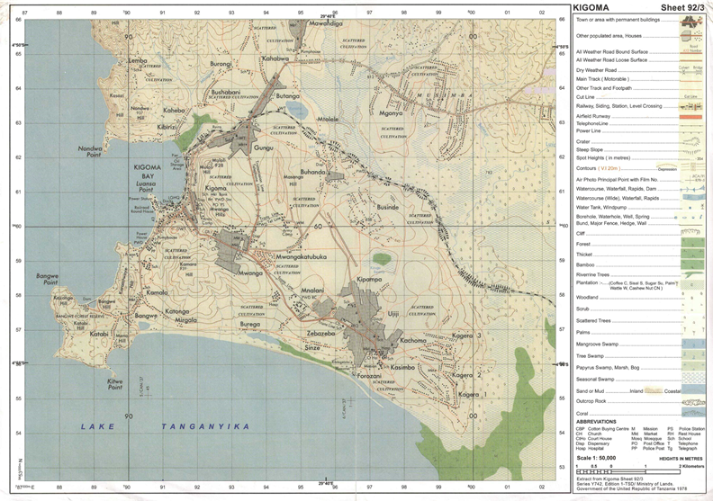
3. Study carefully the map extract of Kigoma (sheet 92/3) and then answer the questions that follows)
- Identify the feature that is found in the following grid references
(i)923617 (ii) 945599 (iii) 910596
- Calculate the area of Lake Tanganyika from 570 southward. Give your answer in km2
- What is the length of railway line from grid reference 944633 Eastward. Give your answer in km.
- With evidence Suggest the type of settlement patterns depicted in the map
- By providing evidence, explain three (3) human activities and two (2) social activities that might be taking place in the area.
4. The following table indicates scores of Geography weekly test for some form four students at Mwakalel secondary school in 2021
| Student | Mwantege | Mwaipaya | Mwabete | Mwatu | Mwaka |
| Score | 70 | 50 | 70 | 80 | 40 |
- Present the data by means of divergence bar graph
- Give two merits and two demerits of method used
5. Assume you are a chain survey or expert in one of the villages and you have been assigned a task of measuring a distance of a river from point A to point B
- Which seven steps will you follow to carry out such task?
- Would you ensure the correctness of measurement as you carry out your task?
6. (a)Mention three of metamorphic rocks
(b)Briefly explain importance of rocks
7. Study carefully the photograph below then answer the questions that follow
- Name the type of photograph
- Describe the possible climate of the area
- Suggest four economic activities that might be taking place in the area
- Suggest three regions in Tanzania where the photograph might have been taken
SECTION C (30 Marks)
Answer two (2) questions from this section
8. Explain any six objectives of constructing the Stigler’s gorge hydro-electric power in Tanzania
9. Manufacturing industry plays a great me to the economic development of a country. Clarify any six (6) constraint which face the development of textile industry in Tanzania
10. Plantation is the most common form of Agriculture practiced in Tropical region of Africa, Asia and South America. Justify six (6) characteristics of plantation practiced in these areas
|
|
FORM FOUR GEOGRAPHY EXAM SERIES 139
FORM FOUR GEOGRAPHY EXAM SERIES 139
THE PRESIDENT’S OFFICE
MINISTRY OF EDUCATION, REGIONAL ADMINISTRATION AND LOCAL GOVERNMENT
SECONDARY EXAMINATION SERIES
GEOGRAPHY MID TERM EXAMINATION
FORM FOUR- MARCH/APRIL -2021
Time: 3 Hours
Instructions.
SECTION A (15 Marks)
Answer All questions in this section.
TIME 3:00 HRS
INSTRUCTIONS
- This paper consists of section A, B and C with a total often (O) questions.
- Answer all questions in section A and B and two (2) questions from section C

- Section A carries fifteen (15) marks; section B fifty-five (55) marks AND section C carries thirty (30) marks.
- Map extract of MKOMAZI (Sheet 109/1).
- Programmable calculators, cellular phones and any unauthorized material are not allowed

- Write your fully name on every page of your answer
SECTION A: 15 MARKS
Answer all questions in this section
l. For each of the following item (i) —(x), choose the correct answer from the given alterative and write its letter In the booklet(s) provided.ssss
- The sun IS surrounded by a layer of gas that has boiled from its surfaces, -
- Corona
- Colona
- Satellite
- Milky way
- Galaxy
- Form tour students from Kibo secondary school visited KIA weather station, but suddenly all of them were shocked to see a white wooden box mounted on 4 legs. What are the instruments found in it?
- Maximum and minimum thermometer
- Hygrometer, wet bulb and rain gauge
- Drv bulb thermometer and barometer
- Six's thermometer and wind vane
iii) Minimum thermometer and wind speed which of the following occurs when the moon's shadow cast over the earth0
- Solar eclipse
- Lunar eclipse
- Aphelion
- Summer solstice
- E) Equinoxes
- A geographer watched national geographic session on TV at Baffin Bay (750W, 780N) at 7:30pm
Tuesday at what time and day will people in Mpanda (450E, 060S) be watching the TV9
- 8.30pm Tuesday
- 3:30pm Wednesday
- 1 1:30pm Wednesday
- 12:30pm Tuesday
- 3:30am Wednesday
- Form four students of Kibo secondary school made simple Investigation around Lake
Victoria with their geography teacher, arc observed that, Lake Victoria is the best example of, -
- Up warping
- Volcanic activity
- Wave action
- Down warping E) Rift valley
- When describing the internal structure of the earth crust which layers, is the following which layer of the earth forms the ocean floor
- Sial
- Core
- Crust D) Mantle E) Sima
- The tourists enjoyed the temperature of Mwanza which was 320C at sea level. They also planned to travel from Mwanza to Arusha which is 1500M above sea level. What will be the temperature experienced by the tourists in Arusha?
A) 90C
- 0 60C
- 170c
- 190C
- 230C
![]() Philemon was living near the mountain. Within a time; he noticed the bending of trees and fences down ward the slope. Identify the type process occur.
Philemon was living near the mountain. Within a time; he noticed the bending of trees and fences down ward the slope. Identify the type process occur.
A) . Mud slide
B). Soil slide
- Soil creep
- Rock fall
- Soil erosion
x) The form three students were told that, soil has certain biological chemical and physical characteristics. What is the general term for these characteristics?
- Soil particles
- Soil properties
- Soil formation
- Soil profile
- soil fertility
- Match the descriptions of the type of agriculture in LJ.ST A with the correct type of agriculture in LIST B by writing the letter of the correct response beside the item number in the answer booklet(s) provided

|
| LIST A | LIST B |
|
|
|
|
SECTION B: 55 MARKS
Answer all questions from this section
- Study the map extract of MKOMANZI (Sheet 109/1) provided then answer die following questions

- Calculate the forest area by grid square in km2

- In which ways the map scale has been expressed?
- With reasons identify the major type of transport found in the mapped area?
- With evidence from the map, describe two geomorphic processes that have shaped the mapped area.
- With two reasons, identify the type of climate in the area
- Calculate the forest area by grid square in km2
- Mr. Lufega is a very good farmer but he does not know how to present the production of his crops by using graphs although he always likes to record the production of each year The table below shows his records of production of some crops as from 2010 to 2013 in "000" tones

| Crops/year | 2010 | 201 1 | 2012 | 2013 |
| Cotton | 65 | 35 | 60 | 70 |
| Wheat | 25 | 30 | 20 | 25 |
| Sisal | 50 | 60 | 45 | 45 |
- Help Mr. Lufega to present the data by using a grouped bar graph
- Explain to Mr. Lufega three advantages Of using the above method of data presented (iii) Comment on the trend of production of Mr. Lufega
- Luciana visited her friend at Mwibate village, she noticed that her friend wanted to conduct survey that she wanted to conduct survey by measuring horizontal distance between two points but there was a pond between the identified points and her friend didn't know how to do any more.
- Name the method of land survey appropriate to her survey.
- Name the method that Luciana would advise her friend to use so as to avoid the pond.
- Draw a diagram showing the method named in 5 (b) above.
- Outline five tools that might be used in the method named in 5(a) above.
- Ngorongoro conservation Authority (NCA) is globally recognized as environmental friendly by allowing socio-interaction of the human being and wildlife within the crater. The Rhino species was nowdays disappearing due to their demand in Asian markets. Nakumbuka as a member of Malihai club from Kibo secondary school was interested to conduct a research on it.
- What will be the research title? o
- Describe the methods used to get information.
- List down two (2) advantages of each method used.
- State three (3) uses of research outputs
-

 Study the photograph provided below and then answer the questions that follow
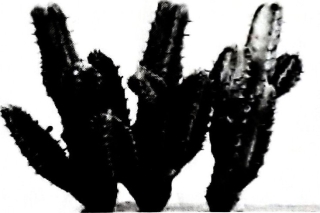
- With reason, identify the type of photograph
- What is the name of the plant shown on the photograph?
- With reason, suggest the climate does the plant named in 7(b) above belong?
- Outline four adoptive mechanisms of the named plant in 7(b) above to its environment.
SECTION C: 30 MARKS
- "The ideally census must cover the whole country and all people residing in the country must be counted." Suppose you have given a task to educate your society about census, why would you tell people that, it is very important for Tanzania government to conduct census? (Explain five (5) points•
- Recently the world is facing a very dangerous pandemic disease (COVID 19) which affects people and their economy. Explain six (6) effects of the pandemic to the tourism sector in Tanzania.
- Human activities enable the livelihood but on other hand they destroy the environment. Justify this statement with six (6) points on the environmental problem resulted by human activities that normally do.
FORM FOUR GEOGRAPHY EXAM SERIES 79
FORM FOUR GEOGRAPHY EXAM SERIES 79
THE PRESIDENT’S OFFICE MINISTRY OF EDUCATION, REGIONAL ADMINISTRATION AND LOCAL GOVERNMENT
SECONDARY EXAMINATION SERIES
FORM FOUR GEOGRAPHY MID TERM EXAMINATION
Time: 3Hours
Instructions.
- This paper consists of section A, B and C with a total of 10 questions
- Answer all questions in section A and B and two questions from section C.
- Section A carries 15 marks, section B 55 marks and section C 30 MARKS
- Map extract sheet for Sikonge(sheet 137/2) is provided.
- Programmable calculators, cellular phones and any other unauthorized materials are not allowed in examination room.
- Write your number on every page of your answer booklet.
SECTION A (15 Marks)
Answer All questions in this section.
- The layer of the earth that forms the ocean floor is
- Mantle
- Sial
- Sima
- Core
- Crust
- Which of the following is not a cause of desertification in Tanzania?
- Deforestation
- Urban growth
- Shift cultivation
- Over fishing
- Bush fire
- The following factors makes Switzerland Attractive to tourists except
- Wildlife
- Good infrastructure
- Best hospitality
- Political stability
- Package tours
- Which of the following occurs when the moon shadow cast over the earth?
- Solar eclipse
- Lunar eclipse
- Equinoxes
- Summer solstice
- Aphelion.
- The upper section of the river is also called
- Young stage
- gradient stage
- old stage
- nature stage
- deposition stage
- It refers to the seasonal variation of water volume in river valley
- river capture
- river rejuvenation
- River regime
- river erosion
- river capture
- Sand dunes and ripples shares similar features in this way
- Have crastinal characteristics
- are formed from ground moraine
- Originated from river activities
- are formed by depositional activities
- are formed in deserts
- Rift valley lakes are normally deep and narrow, a good example is
- Lake Baringo and Nakuru in Kenya
- Lake Victoria in Tanzania
- Lake Volta in Ghana
- Qattara Depressions in Egypt
- Lake chad
- A basin which consists of layers of permeable rock lying between two layers of impermeable rock is called.
- Well
- Spring
- artesian basin
- artesian well
- rill
- Which of the following is involved in deforming the structure of the earth?
- gravitation force
- denudation
- deforestation
- overgrazing
- earth quake.
2. Match the description of the types of agriculture in LIST A with the correct type of Agriculture in LIST B by writing the letter of the correct answer beside the item number in answer booklet provided.
| LIST A | LIST B |
|
|
3. Carefully study the map extract of sikonge provided then answers the questions that follow
- Calculate the total distance covered in kilometers if the car was travelling from Sikonge town (732787) to Lyombakuzoa church (755765) and turned back to Sikonge town.
- With evidence from the map, describe the nature of relief in mapped area
- Calculate the gradient from grid reference 835846 to 782786
- Find the highest point on the given map and give its grid references and direction
- State the general direction of the slope of the land in the mapped area.
4. Read carefully the hypothetical data representing each crop production in Tanzania in “000” tones, and then answer the questions after it.
| YEARS | COFFEE | COTTON | TEA |
| 1980 | 200 | 150 | 250 |
| 1981 | 150 | 200 | 150 |
| 1982 | 130 | 100 | 100 |
a) Mention 5 methods which the given data may be presented.
b) Present the data above through comparative line graph.
c) Why there is a decrease of Tea production year after year (3-reasons).
5. a) What is meant by Research
b) Briefly explain the importance of research to students. (4 points)
c) Differentiate between Primary data and secondary data.
6. a) Define these terms as applied to surveying technique.
- Levelling
- Chaining
- Forward Bearing
- Booking
b) What are shortcomings of using a “chain” as a measuring instrument where surveying a place (5 points)
8. Study this photograph and then answer the next questions.
Questions
i) What type of photograph is this?
ii) Suggest the natural feature seen at large
iii) Suggest the limitation of the types of transport displayed on photograph-(2 limitation)
iv) Write two significances of the area
v) Suggest two places where the photo might have been taken
SECTION C (30 MARKS)
8. Tanzania is endowed with large virgin lands for farming but yet there is a problem of food shortage, suggest 6 causes for food shortage in Tanzania.
9. Analyze 6 benefits of livestock keeping in East African countries
10. Migration is caused by push and pull factors. Using six points, Justify this statement.
FORM FOUR GEOGRAPHY EXAM SERIES 47
FORM FOUR GEOGRAPHY EXAM SERIES 47

DOWNLOAD LEARNING HUB APP NOW

SORRY, YOU CAN'T VIEW THIS MARKING SCHEME PLEASE DOWNLOAD LEARNING HUB APP FROM PLAYSTORE TO GET FULL ACCESS TO ALL MARKING SCHEME!!
Click Here To Download Learning Hub Tanzania App
SAMAHANI, HUWEZI KUFUNGUA MAJIBU YA MTIHANI, TAFADHALI PAKUA APP YA LEARNING HUB TANZANIA ILI KUWEZA KUFUNGUA MAJIBU YA MITIHANI KATIKA TOVUTI HII!!
Bofya Hapa Kupakua App Ya Learning Hub Tanzania
Hub App
 For Call,Sms&WhatsApp: 255769929722 / 255754805256
For Call,Sms&WhatsApp: 255769929722 / 255754805256  Matokeo Darasa VII 2025
Matokeo KIDATO CHA II 2024
Matokeo Darasa IV 2024
SECONDARY REGIONAL EXAMS
PRIMARY REGIONAL EXAMS
FORM VI NECTA REVIEWS
FORM IV NECTA REVIEWS
FORM II NECTA REVIEWS
STD VII NECTA REVIEWS
STD IV NECTA REVIEWS
SECONDARY EXAMS SERIES
PRIMARY EXAMS SERIES
PRIMARY SUBJECT NOTES
SECONDARY SUBJECT NOTES
SECONDARY TOPICAL EXAMS
SECONDARY TOPICAL QUESTIONS
PRIMARY TOPICAL QUESTIONS
PRACTICAL EXAMS & NOTES
SECONDARY REGIONAL EXAMS
DOWNLOAD SUBJECT NOTES
SCHEMES OF WORK (PRIMARY & SECONDARY)
LESSON PLAN
SECONDARY LOG BOOKS
PRIMARY LOG BOOKS
LITERARY WORKS / UCHAMBUZI VITABU
METHALI ZOTE ZA KISWAHILI
Vitendawili Vya Kiswahili
FORM VI RESULTS 2024
FORM FIVE SELECTION 2024
MATOKEO KIDATO CHA IV 2023
FORM ONE SELECTION 2024
FORM VI RESULTS 2023
Matokeo Darasa IV 2022
Matokeo Darasa VII 2025
Matokeo KIDATO CHA II 2024
Matokeo Darasa IV 2024
SECONDARY REGIONAL EXAMS
PRIMARY REGIONAL EXAMS
FORM VI NECTA REVIEWS
FORM IV NECTA REVIEWS
FORM II NECTA REVIEWS
STD VII NECTA REVIEWS
STD IV NECTA REVIEWS
SECONDARY EXAMS SERIES
PRIMARY EXAMS SERIES
PRIMARY SUBJECT NOTES
SECONDARY SUBJECT NOTES
SECONDARY TOPICAL EXAMS
SECONDARY TOPICAL QUESTIONS
PRIMARY TOPICAL QUESTIONS
PRACTICAL EXAMS & NOTES
SECONDARY REGIONAL EXAMS
DOWNLOAD SUBJECT NOTES
SCHEMES OF WORK (PRIMARY & SECONDARY)
LESSON PLAN
SECONDARY LOG BOOKS
PRIMARY LOG BOOKS
LITERARY WORKS / UCHAMBUZI VITABU
METHALI ZOTE ZA KISWAHILI
Vitendawili Vya Kiswahili
FORM VI RESULTS 2024
FORM FIVE SELECTION 2024
MATOKEO KIDATO CHA IV 2023
FORM ONE SELECTION 2024
FORM VI RESULTS 2023
Matokeo Darasa IV 2022


