Pupil’s name: _______________________________________
School name: ___________________________________________
PRIME MINISTER’S OFFICE, REGIONAL ADMINISTRATIVE AND LOCAL GOVERNMENT
TERMINAL EXAMINATION FOR STD FIVE 2026
SUBJECT- GEOGRAPHY AND ENVIRONMENT
SECTION A: GEOGRAPHY AND ENVIRONMENT (26MARKS)
Answer all questions in this section.
1. For each of the items (i) – (xv), choose the correct answer and write its letter in the box provided:
i. Which of the following is not classify as a natural resource in the vegetable farming projects?
- Land
- water
- labour
- seed
- minerals
ii. Which resource directly enables the actual growth of vegetable crops?
- Money
- machinery
- seeds
- labour
- storage facilities
iii. A community in Tanzania wants to develop a sustainable income source from their local forest. Which forest-related activity would best provide income while preserving the forest’s environmental functions?
- Clear-cutting all trees for timber scale
- Establishing a beekeeping project in the forest
- Converting the forest into agricultural farmland
- Mining minerals inside the forest area
- Using the forest only for firewood collection without replanting
iv. The Tanzania National Parks Authority (TANAPA) needs to decide which action will most effectively protect the “big five” wildlife in a national park. Which management action is most appropriate?
- Allowing unrestricted tourist hunting of big five
- Expanding agricultural zones inside the park
- Creating stricter anti-poaching patrols and habitat protection
- Relocating the big five to private farms
- Reducing the park’s protected area size
v. Some children have a tendency of defecating and urinating in water sources. What is the effects of that act?
- Increase of fish
- Increase of water
- spread of diseases
- purify water
- treat water
vi. Mr. Njate climbed Mount Kilimanjaro and reached the summit after three days. What did he see on the top of the Mountain?
- Ocean and dam
- Manmade snow
- Stone’s house only
- Snow
- accumulation of mud
2. Answer items (i) – (v) by matching the location of the national parks found in Tanzania in List A with their name in List B and write the letter of the correct response in the bracket provided.
| LIST A | Answer | LIST B |
| i. North-western (Mara, Arusha, Simiyu) | A. Serengeti B. Tarangire C. Kondoa Irangi D. Lake Manyara E. Ngorongoro F. Ruaha G. Gombe | |
| ii. Northern (Manyara, Arusha, Dodoma? | ||
| iii. Northern ( Arusha and Manyara) | ||
| iv. Southern western (Iringa and Mbeya) |
3. i. What is the contribution of Gold to Tanzania economy ?
- _______________________________________
- _______________________________________
ii. Tanzania is also rich in renewable resources. Mention any two renewables resources.
- _______________________________________
- __________________________________
iii. To promote the blue economy sector, what sustainable use of resources should we focus on?
- ________________________________________
- ______________________________
4.Study the following map and then answer question (a) – (d) by writing the correct answer in the space provided.
A MAP OF MSANGALALE WARD

Questions:
a) How many mountains are there on map above?
________________________________________________________
b) Name any two man- made features shown on the map.
i) _______________________________________
ii) _________________________________________
c) What is the direction of the mosque from the church?
_________________________________________________________
d) How many bridges are there on the map above?
_________________________________________________________
e) What symbol from the map stand for the natural feature of the mountain? Draw the symbol.
__________________________________________________________
SECTION B: SPORT AND ARTS ( 24MARKS)
5. Choose the correct answer and write its letter in the box provided.
i. The following are drawing tools except
A: Duster B: A water C: A pencil D: Table and chair
ii. Which types of performing art is popular with pupils?.
(A)Story telling (B)music (C) Recitation (D) Modelling
iii. What is the name of the clothes used by actors during performances?
(A) Costume(B) Make up (C) Materials (d) clothes
iv .________is the art of portraying a character is a story or on a stage.
(A) praying ( B) Acting (C) Running (D) Jumping
6. Match the items in list A against those in list B by writing the letter of the correct sentences beside the item number.
| COLUMN A | COLUMN B | ||
| I | Rattle | | A. Struck instruments B. Cup C. Kayamba D. Flute F. A traditional game played by two people using small seeds or shells G. A game that is played by using hands by tree people H. Percussion instrument |
| Ii | Drum | | |
| iii | Bao | | |
| iv | Wind instruments | | |
| v. | Rede | |
7. (a) Mention two main things to consider when acting out with actions and sound.
(i)_________________________________________
(ii)_________________________________________
b.The children seen in the picture below are actors preparing to perform.

QUESTIONS
i. What are people who do performing arts called? __________________________
ii. What is that play called?._____________________________________________
iii. What are the clothes they are wearing called? ___________________________________
LEARNINGHUBTZ.CO.TZGEOGRAPHY STANDARD FOUR EXAM SERIES 131

LEARNINGHUBTZ.CO.TZGEOGRAPHY STANDARD FOUR EXAM SERIES 118
LEARNINGHUBTZ.CO.TZGEOGRAPHY STANDARD FOUR EXAM SERIES 117
LEARNINGHUBTZ.CO.TZGEOGRAPHY STANDARD FOUR EXAM SERIES 116
OFFICE OF THE PRESIDENT, REGIONAL ADMINISTRATION AND LOCAL GOVERNMENT
PRIMARY EXAMINATION SERIES
MARCH 2025
STANDARD FOUR, GEOGRAPHY AND ENVIRONMENT
- MULTIPLE CHOICES
- What does the study of geography deal with?
(A)relief features and settlements only
(B) human activities and physical features
(C) water bodies and plants only
(D) everything on the land
- Juma lives near lake Victoria which economic activity is he likely to practise
(A) agriculture
(B) lumbering
(C) fishing
(D) mining
- The following are feature we study on the earth except
(A) atmosphere
(B) land
(C) water bodies
(D) history
iv. Moses lives in Mafinga Iringa, where there is a dense forests. Which economic activity is he likely to practice
(A) fishing
(B) lumbering
(C) mining
(D) construction
v. The following are branches of Geography except
(A) photography interpretation geography
(B) human geography
(C) physical Geography
(D) practical geography
vi. Which of the following refers to the atmospheric condition experienced over a short period, it many be an hour
(A) weather
(B) resources
(C) disaster
(D) climate
vii. The process of cutting down trees for charcoal, timber is called
(A) afforestation
(B)re- a forestation
(C) deforestation
(D) air pollution
viii. Mr. John works in a timber processing factory. So Mr john experiences
(A) air pollution
(B) noise pollution
(C) water pollution
(D) land pollution
ix. The following are sources of water sources except
(A)river
(B) lake
(C) building
(D) dam
x. People who travel to places of interest for study or leisure are called
(A) traders
(B) students
(C) drivers
(D) tourist
xi. Which of the following is physical features
(A) mountain
(B) mountain
(C) river
(D) lake
xii. Among the following is a man- made feature .
(A) darn
(B) lake
(C) valley
(D) river
xiii. The tallest mountain in Tanzania is called
(A) Mt. Meru
(B) Mt. Oldonyo Lengai
(C) Mt. Kilimanjaro
(D) Mt. Uluguru
xiv. Human residences in towns and cities are called settlements
(A) village
(B) urban
(C) commercial
(D) rural
xv. The extraction of minerals from the under ground is called
(A) fishing
(B) mining
(C) lumbering
(D) agriculture
SECTION B:
4. MATCHING ITEMS
| LIST A | ANSWER | LIST B |
|
| A. Compass directions |
|
| B. Frame |
|
| C. Key |
|
| D. Title |
|
| E. Scale |
|
|
|
|
SECTION C:
STRUCTURE
5. i. What is the meaning of direction?
ii. Define re-afforestation
Use the compass direction below to answer questions
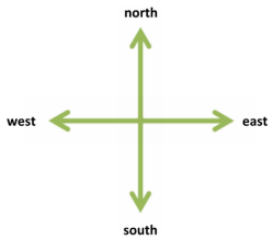
- Which direction does the sun set
- Which direction is Mt Kilimanjaro from our school Patrick Primary school
- Which direction does the sun rise
LEARNINGHUBTZ.CO.TZGEOGRAPHY STANDARD FOUR EXAM SERIES 111

DOWNLOAD LEARNING HUB APP NOW

SORRY, YOU CAN'T VIEW THIS MARKING SCHEME PLEASE DOWNLOAD LEARNING HUB APP FROM PLAYSTORE TO GET FULL ACCESS TO ALL MARKING SCHEME!!
Click Here To Download Learning Hub Tanzania App
SAMAHANI, HUWEZI KUFUNGUA MAJIBU YA MTIHANI, TAFADHALI PAKUA APP YA LEARNING HUB TANZANIA ILI KUWEZA KUFUNGUA MAJIBU YA MITIHANI KATIKA TOVUTI HII!!
Bofya Hapa Kupakua App Ya Learning Hub Tanzania
Hub App
 For Call,Sms&WhatsApp: 255769929722 / 255754805256
For Call,Sms&WhatsApp: 255769929722 / 255754805256  RATIBA NECTA KIDATO CHA IV 2026
Matokeo Darasa VII 2025
Matokeo KIDATO CHA II 2024
Matokeo Darasa IV 2024
SECONDARY REGIONAL EXAMS
PRIMARY REGIONAL EXAMS
FORM VI NECTA REVIEWS
FORM IV NECTA REVIEWS
FORM II NECTA REVIEWS
STD VII NECTA REVIEWS
STD IV NECTA REVIEWS
SECONDARY EXAMS SERIES
PRIMARY EXAMS SERIES
PRIMARY SUBJECT NOTES
SECONDARY SUBJECT NOTES
SECONDARY TOPICAL EXAMS
SECONDARY TOPICAL QUESTIONS
PRIMARY TOPICAL QUESTIONS
PRACTICAL EXAMS & NOTES
SECONDARY REGIONAL EXAMS
DOWNLOAD SUBJECT NOTES
SCHEMES OF WORK (PRIMARY & SECONDARY)
LESSON PLAN
SECONDARY LOG BOOKS
PRIMARY LOG BOOKS
LITERARY WORKS / UCHAMBUZI VITABU
METHALI ZOTE ZA KISWAHILI
Vitendawili Vya Kiswahili
FORM VI RESULTS 2024
FORM FIVE SELECTION 2024
MATOKEO KIDATO CHA IV 2023
FORM ONE SELECTION 2024
FORM VI RESULTS 2023
Matokeo Darasa IV 2022
RATIBA NECTA KIDATO CHA IV 2026
Matokeo Darasa VII 2025
Matokeo KIDATO CHA II 2024
Matokeo Darasa IV 2024
SECONDARY REGIONAL EXAMS
PRIMARY REGIONAL EXAMS
FORM VI NECTA REVIEWS
FORM IV NECTA REVIEWS
FORM II NECTA REVIEWS
STD VII NECTA REVIEWS
STD IV NECTA REVIEWS
SECONDARY EXAMS SERIES
PRIMARY EXAMS SERIES
PRIMARY SUBJECT NOTES
SECONDARY SUBJECT NOTES
SECONDARY TOPICAL EXAMS
SECONDARY TOPICAL QUESTIONS
PRIMARY TOPICAL QUESTIONS
PRACTICAL EXAMS & NOTES
SECONDARY REGIONAL EXAMS
DOWNLOAD SUBJECT NOTES
SCHEMES OF WORK (PRIMARY & SECONDARY)
LESSON PLAN
SECONDARY LOG BOOKS
PRIMARY LOG BOOKS
LITERARY WORKS / UCHAMBUZI VITABU
METHALI ZOTE ZA KISWAHILI
Vitendawili Vya Kiswahili
FORM VI RESULTS 2024
FORM FIVE SELECTION 2024
MATOKEO KIDATO CHA IV 2023
FORM ONE SELECTION 2024
FORM VI RESULTS 2023
Matokeo Darasa IV 2022


