THE PRESIDENT'S OFFICE
MINISTRY OF REGIONAL GOVERNMENT AND LOCAL GOVERNMENT
PRE-NATIONAL EXAMINATION SERIES-1
GEOGRAPHY FORM-4
2020
TIME: 3:00 HRS
Instructions
- This paper consists of sections A, B and C with a total of ten (10) questions.
- Answer all questions in sections A and B and any two (2) questions from section C.
- Map extract of Mkomazi (Sheet 109/1) is provided.
- Programmable calculators, cellular phones and unauthorised materials are not allowed in the examination room.
- Write your Examination Number on every page of your answer booklet(s).
SECTION A (15 Marks)
Answer all questions in this section.
1. For each of the items (i) — (x), choose the correct answer from among the given alternatives and write its letter besides the item number in the answer booklet provided.
(i) Which of the following layers of the earths interior is made up of sima and sial?
- Biosphere
- Hydrosphere
- Asthenosphere
- Lithosphere
- Barysphere
(ii) Senegal National team scored a goal at 2:00 pm in Senegal (1500 W). At what time at Burundi (300 E) the goal was scored?
- 2:00 am
- 10:00 am
- 4:00 am
- 10:00 pm
- 12:00 am
(iii) Which of the following is the process of wearing down the rock surface by wind where the load becomes cutting tools?
- Deflation
- Attrition
- Abrasion
- Corrasion
- Hydration.
(iv) The renewed power of erosion of a river is called.
- river capture
- river erosion
- river rejuvenation
- river meanders
- river basin.
(v)Prediction of the state of atmosphere in a region for 24 to 48 hours is known as
- weather elements
- weather report
- weather instrument
- weather station
- weather forecasting
(vi) Deposition of soil materials removed from one horizon to another is called
- Convex sided
- Concave sided
- Gentle sided resistance
- Steep sided resistant
- Steep sided non resistance.
(vii) The excessive strong wind blowing across an extensive ocean surface is called
- Tsunami
- Ocean currents
- Storm s urge
- Hurricane
- Wind.
(viii) Rainfall that occurs when the air moves towards a hill or a mountain is called
- cyclonic
- orographic
- convectional
- showers
- typhoon.
(ix) An active state of decomposition caused by soil microorganism is called
- organic matter
- soil water
- mineral matter
- soil air
- soil components.
(x) The name given to earthquake waves that travel within a crust is
- focus
- epicentre
- seismic
- surface waves
- body waves.
2. Match the items in List A with the responses in List B by writing the letter of the correct response beside the item number in the answer booklet provided.
| LIST A | LIST B |
| (i) A mass of magma which has emerged on the earth’s surface. (ii) A wall like feature formed when magma cuts across a bedding plane. (iii) A sheet of magma which lies along a bedding plane. (iv) A very large mass of magma which often forms the root of a mountain. (v) A dome-shaped feature formed when magma push up the overlaying layers. |
|
SECTION B (55 Marks)
Answer all questions in this section.
3. Study the map extract of Mkomazi (Sheet 109/1) and then answer the following questions:
- By using the given RF scale, measure the distance of river Pangani in kilometres from grid reference 910771 to 910826.
b. Describe relief of the area.
c. With reasons, identify two types of rocks found in the map.
d. Name the major way used to show the height of the land in the mapped area.
e.Using a vertical scale of lcm to represent 50m, draw an annotated cross section from grid reference 960820 to 910880 and mark Ruvu river basin and the main trucks.
4. (a) Explain the meaning of the standard deviation.
(b) Study the following data showing the age of the Primary School pupils at Tumaini Primary School and answer the questions that follow: 15, 8, 7, 6, 12, 5, 14 and 13.
(i) Determine the range and median of the age of the pupils.
(ii) Calculate the standard deviation.
5. Form three students at Nguvumali secondary school would like to conduct a simple chain survey around their school compound and measure the height of the big gully near the headmaster’s office. Describe the significance of survey in Tanzania
6. (a) What is meant by sampling techniques as used in research?
(b) Briefly explain the following concepts as they are applied in sampling:
(i) A sample
(ii) Random sampling
(iii) Systematic sampling
(iv) Stratified sampling
(c) Outline the procedures of conducting an interview.
7. Study the photograph given below and then answer the questions that follow:
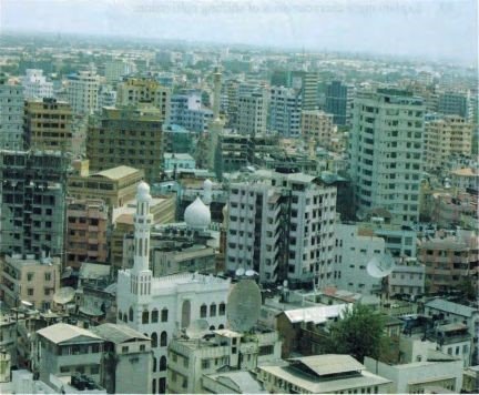
(a) With two reasons, identify the type of the photograph.
(b) Identify the type of the settlement pattern seen on the photograph.
(c) Name two economic importances of the area shown on the photograph.
(d) Explain two social and environmental problems that are likely to occur in the area.
SECTION C (30 Marks)
Answer two (2) questions from this section.
8. Describe seven problems associated with rapid urbanization.
9. Describe five measures to control floods to the environment.
10. Analyse six potentials of the Rufiji river basin.
LEARNINGHUBTZ.CO.TZFORM FOUR GEOGRAPHY MODAL SERIES 22
THE PRESIDENT’S OFFICE MINISTRY OF EDUCATION, LOCAL ADMINISTRATION AND LOCAL GOVERNMENT
GEOGRAPHY- POST-MOCK- EXAMINATION-JUNE
FORM FOUR
Time 3:00 Hours JUNE 2020
Instructions
- This paper consists of sections A, B, and C.
- Answer all questions in sections A, and B two questions from section C.
- Map extract of Ilonga (Sheet 265/2) is provided.
- Credit will be given for the use of relevant diagrams.
- Calculators and Cellular phones are not allowed in the examination room.
- Write your Examination Number on every page of your answer booklet(s)
SECTION A
(i) Which of the following layers of the earths interior is made up of sima and sial?
- Biosphere
- Hydrosphere
- Asthenosphere
- Lithosphere
- Barysphere
(ii) Senegal National team scored a goal at 2:00 pm in Senegal (1500 W). At what time at Burundi (300 E) the goal was scored?
- 2:00 am
- 10:00 am
- 4:00 am
- 10:00 pm
- 12:00 am
(iii) One of the factors for soil formation is
- organic matters
- mineral matters.
- time.
- water.
- air.
(iv) Which among the following is a heavenly body that possesses and transmits its own light?
- Moon
- Sun
- Earth
- Astreroid
- Planet.
(v) Which among the following features are produced by wave erosion?
- A Geo, wave cut platform and stack
- Blow hole, sea arch and levee
- Sea arch, beach and stump
- Beach, spit and bars.
- Tombolo, meander and cliff.
(vi) Prediction of the state of atmosphere in a region for 24 to 48 hours is known as
- weather elements
- weather report
- weather instrument
- weather station
- weather forecasting
(vii) Which of the following instrument is used to measure maximum and minimum temperature?
- Barometer
- Thermometer
- Anemometer
- Sixs thermometer
- Hydrometer.
(viii) The process of changing granite to gneiss rock is known as
- sedimentation
- vulcanism
- denudation
- metamophism
- exfoliation.
(ix) Zeugens and yadangs differ in
- position of the rock strata
- position of the rock in the slope
- place of formation
- colour of the rock on which they are formed
- the type of the rock on which they are formed.
(x) Which of the following features produced by ice action is the result of both erosional and depositional activities?
- Arête.
- Hanging Valley.
- Erratic.
- Cirque.
- Roche Mountonee.
2. Match the descriptions of karst region features in Column A with the corresponding feature in Column B by writing the letter of the correct answer beside the item number in the answer booklet provided.
| LIST A | LIST B |
|
|
SECTION B (55 Marks)
Answer all questions in this section.
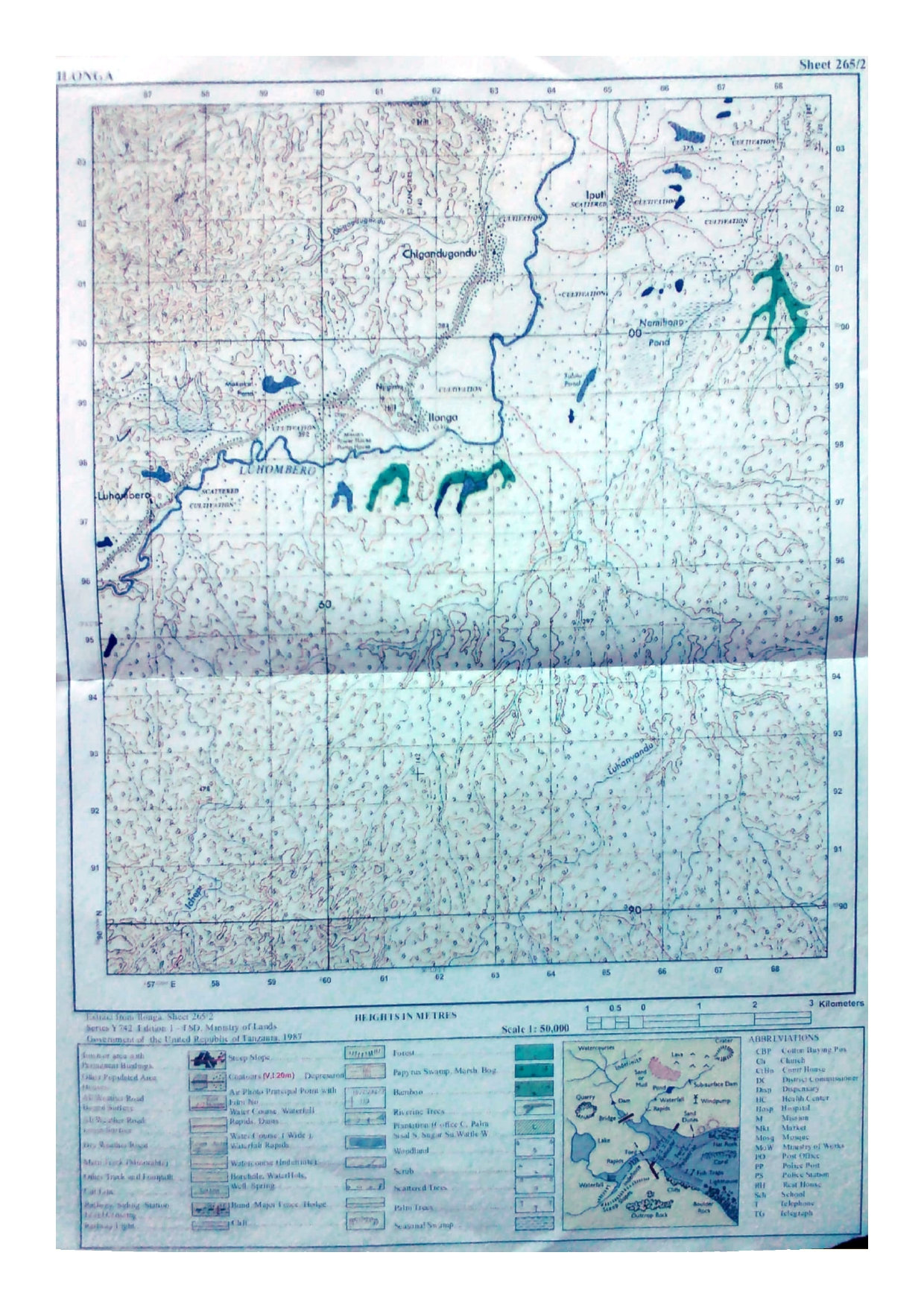
3. Study the map extract of Ilonga (Sheet 265/2) and answer the following questions:
a. By using square method, determine the area North western of Luhombero river from grid reference 570963 to 644034.
b. With evidence from the map, name six symbols which have been used to inteprete a given map.
c. Give the direction of Iputi to Ilonga.
d. Describe the settlement pattern of the mapped area.
e. Giving evidences, mention five possible economic activities which might take place in the mapped area.
4. (a) Give three differences between interview and observation.
(b) Outline four merits of library research.
5. Explain five importance of survey in daily life.
6. (a) Define compound bar graph.
(b) Study carefully the table below on hypothetical data about cash crops production (in ‘000 tonnes) in East Africa in the year 2000, then answer the questions that follow. Find this
| Country | Crops | ||
| Coffee | Tea | Cotton | |
| Kenya | 2200 | 2000 | 1800 |
| Uganda | 1700 | 700 | 800 |
| Tanzania | 1300 | 1900 | 2300 |
(i) Draw compound bar graphs to represent the data provided.
(ii) Outline four merits of using compound bar graph.
7. (a) Describe discordant drainage system.
(b) Explain the process of river transport and describe four ways in which a river transports its load.
SECTION C (30 Marks)
Answer two (2) questions from this section.
8. Describe seven problems associated with rapid urbanization.
9. Analyse six potentials of the Rufiji river basin.
10.Elaborate seven ways of managing industrial pollutants to the environment.
LEARNINGHUBTZ.CO.TZFORM FOUR GEOGRAPHY MODAL SERIES 17
LEARNING HUB TANZANIA
CODE 013 GEOGRAPHY

INSTRUCTIONS TIME 3:00Hrs
1. This paper consists of three sections A, B, and C.
2. Answer all questions in section A and B and two (2) questions from section C
3. All writings should be in blue or black ink, diagrams should be in pencil
4. Write your examination number on every page of your answer sheet(s) or booklet(s)
5. Cellular phones are not allowed in the examination room.
SECTION A. (15 MARKS)
PHYSICAL AND MATHEMATIC GEOGRAPHY
Answer all questions in this section.
l . For each of the items (i) � (x) choose the correct answer from among the given alternatives.
 Which of the following give the proof that the earth is spherical in shape?
A. Circumnavigation of the earth, solar eclipse and lunar eclipse.
B. Ship visibility, lunar eclipse and aerial photography
C. Great circles, longitude and small circle
D. Latitude and small circles
E. Longitude and latitude.
ii. Geography is sub divided into;
- Practical, human and economic
- Physical, practical demography
- Human economic , practical, physical
- Practical, survey, statistics
- Practical, statistical, human
iii. When do we get summer solstice in southern hemisphere?
- 23 rd September
- 21 st June
- 22nd December
- 21 st March
- 21 st September
iv) In geography the term rotation means:
- The spinning of the body on its axis
- The movements of one body around another
- The movement of the sun
- The rise of the moon in the east
- The movement of planets around another
v. An old stage of the river is called
A. Valley stage B. Torrent stage C. Plain stage D. Mature stage
E. Youth F. Full stage
vi. The part of the earth that forms continental blocks is called;
A. Sima B. Sial C. Core D. Mantle E. Crust
vii. The tropical savannah land is potentially important for the 
- Extensive wheat farming
- Irrigation farming
- Large plantation of cocoa
- Cattle rearing
- Intensive
E. The equatorial region
ix. Which of the following features are the impacts of water action in the deserts?A. Yardangs B. Zeugens C. Gullies D. Sink hole E. Bad lands
x. A vertical cross section of the soil showing its horizons is called
A. Soil profile B. Soil porosity C. Soil erosion D. Soil pH
E. Soil catena
2. Match the items in LIST A with the responses in LIST B by writing the letter of the correct response in the answer sheet(s) or booklet(s) provided.
| LIST A |
| LIST B |
| i. Earths zone which is rich in nickel iron ii. Forces which mainly cause reverse fault iii. A dome shaped features formed when magma push up overlaying layers. iv. A sheet of magma which lies a long a bedding plane v. The zone of faults often developed into a valley | A. B. C. D. E.. F. G. | Mantle Core Rift valley Laccolith Batholith Compressional force Dyke |
SECTION B (55 MARKS)
Answer all questions in this section.
APPLICATION OF STATISTICS, INTRODUCTION TO RESEARCH, ELEMENTARY SURVEY, MAP READING AND PHOTOGRAPHY INTERPRETATION
3. The following table shows production of crops in Tanzania from 1970 � 1973, Study it then answers the questions that follows.
| Crops/year | 1970 | 1971 | 1972 | 1973 |
| Millet | 115,000 | 105,OOO | 120,000 | 135,000 |
| G/Nuts | 85,000 | 95,000 | 110,000 | 125,000 |
| Rice | 210,000 | 320,000 | 325,000 | 345,000 |
 a. Construct a comparative bar graph
b. Give two advantages and two disadvantages of the graph in (a) above
4. (a) What is an interview?
b. Analyses five (5) things to be adhered for a researcher to have a successful interview.
5. Obstacles are common in chain survey due to various features that exist on the earths surface. By using diagrams explain four (4) methods to overcome obstacles in chain.
6. Study carefully the map extract of Kasamwa (Sheet 32/4), Then answer the questions that follow;
(a) Identify two ways that have been used to show relief on the map
(b) Identify the length of all weathered road in KM from grid reference 315844 to 443940.
(c) Find the bearing of Chabulongo hill at 367917 to a school at Nyamahuna 34981 8

(d) Suggest three (3) economic activities practice in this area.
7. Study the photography provided and then answer the questions that follow;
(a) Identify the type of the photography
(b) By providing evidence from the photography describe the relief of the area.
(c) Explain three possible factors which have contributed to the growth of this town.
(d) Explain two similarities between map and photography.
SECTION C (30 MARKS)
Answer two (2) questions from this section.
8. Discuss the reasons for the low level of industrial development in Sub � Sah an Africa (six points)
9. Explain the six (6) environmental factors which influence population distribution in Tanzania.
10. Drawing experience from your local areas and the world in general, elaborate six (6) main environmental problems facing East African Counties.
SECTION C (30 MARKS)
Answer two (2) questions from this section.
8. Discuss the reasons for the low level of industrial development in Sub � Saharan Africa (six points)
9. Explain the six (6) environmental factors which influence population distribution in Tanzania.
10. Drawing experience from your local areas and the world in general, elaborate six (6) main environmental problems facing East African Countries.
4
LEARNINGHUBTZ.CO.TZFORM FOUR GEOGRAPHY MODAL SERIES 13

 For Call,Sms&WhatsApp: 255769929722 / 255754805256
For Call,Sms&WhatsApp: 255769929722 / 255754805256  Matokeo Darasa VII 2025
Matokeo KIDATO CHA II 2024
Matokeo Darasa IV 2024
SECONDARY REGIONAL EXAMS
PRIMARY REGIONAL EXAMS
FORM VI NECTA REVIEWS
FORM IV NECTA REVIEWS
FORM II NECTA REVIEWS
STD VII NECTA REVIEWS
STD IV NECTA REVIEWS
SECONDARY EXAMS SERIES
PRIMARY EXAMS SERIES
PRIMARY SUBJECT NOTES
SECONDARY SUBJECT NOTES
SECONDARY TOPICAL EXAMS
SECONDARY TOPICAL QUESTIONS
PRIMARY TOPICAL QUESTIONS
PRACTICAL EXAMS & NOTES
SECONDARY REGIONAL EXAMS
DOWNLOAD SUBJECT NOTES
SCHEMES OF WORK (PRIMARY & SECONDARY)
LESSON PLAN
SECONDARY LOG BOOKS
PRIMARY LOG BOOKS
LITERARY WORKS / UCHAMBUZI VITABU
METHALI ZOTE ZA KISWAHILI
Vitendawili Vya Kiswahili
FORM VI RESULTS 2024
FORM FIVE SELECTION 2024
MATOKEO KIDATO CHA IV 2023
FORM ONE SELECTION 2024
FORM VI RESULTS 2023
Matokeo Darasa IV 2022
Matokeo Darasa VII 2025
Matokeo KIDATO CHA II 2024
Matokeo Darasa IV 2024
SECONDARY REGIONAL EXAMS
PRIMARY REGIONAL EXAMS
FORM VI NECTA REVIEWS
FORM IV NECTA REVIEWS
FORM II NECTA REVIEWS
STD VII NECTA REVIEWS
STD IV NECTA REVIEWS
SECONDARY EXAMS SERIES
PRIMARY EXAMS SERIES
PRIMARY SUBJECT NOTES
SECONDARY SUBJECT NOTES
SECONDARY TOPICAL EXAMS
SECONDARY TOPICAL QUESTIONS
PRIMARY TOPICAL QUESTIONS
PRACTICAL EXAMS & NOTES
SECONDARY REGIONAL EXAMS
DOWNLOAD SUBJECT NOTES
SCHEMES OF WORK (PRIMARY & SECONDARY)
LESSON PLAN
SECONDARY LOG BOOKS
PRIMARY LOG BOOKS
LITERARY WORKS / UCHAMBUZI VITABU
METHALI ZOTE ZA KISWAHILI
Vitendawili Vya Kiswahili
FORM VI RESULTS 2024
FORM FIVE SELECTION 2024
MATOKEO KIDATO CHA IV 2023
FORM ONE SELECTION 2024
FORM VI RESULTS 2023
Matokeo Darasa IV 2022


