 Regional Exams
 THE PRESIDENT’S OFFICE
REGIONAL ADMINISTRATION AND LOCAL GOVERNMENT
SECONDARY EXAMINATION SERIES
ANNUAL EXAMINATION, NOV -2023
FORM THREE
GEOGRAPHY
INSTRUCTIONS TIME:2: 30
- This Paper Consist Two Section A & B With A Total Of Twelve (12) Questions.
- Answer All Questions In Section ‘’A ‘’ And Two Question From Section ‘’B’’
- Section “A” Caries Seventy (15) Marks, Section B’’ Thirty (30) Marks.
- Programmable Calculator, Cellular Phones And Any Unauthorized Materials Are Not Allowed In The Examination Room.
- Write Your Name On Every Page Of Your Answer Sheet.
SECTION A (16-MARKS)
- For each of items (i) – (ix), choose the most correct answer from among given alternatives given and write its letter on your answer sheet beside item number
- One of the following is a set of factors affecters climate
- Ocean Current, altitude sleet and Barometer
- Distance from sees rainfall, cloud cover, latitude
- Prevailing wind, latitude, rainfall, hygrometer aspect
- Altitude, Temperature, and Earth notation
- Humidity, dew point, atmosphere pressure raingauge
- Soil has physical, chemical and Biological properties which of the following are physical properties of soil
- Colour, clay, texture, structure and porosity
- Porosity, colour, texture, density and structure
- Texture, silt, structure, porosity and sand
- Porosity, profile, structure, Texture and fertility
- Fertility, structure, texture, porosity and colour
- Which statement is true regarding air transport
- It facilitates integration of global economy
- It is the fastest means of transport in the world
- It is the most appropriate means of transport for perishable goods
- It is categorized into local and domestic
- It is one of the most expensive means of Trans sport
- If the minimum temperature recorded in a day to 12°C and maximum temperature recorded in C day is 38°C. Find daily range temperature.
- 50°C
- 26°C
- 50°C
- 26°C
- 55°C
- The following are aspects of physical geography except
- Natural features of the earth
- Structure of the earth
- Distribution of plants and animal
- Population growth and distribution
- Formation and Distribution of land forms
- Suppose you want to invest and engage in commercial livestock-keeping. Which three categories of Commercial livestock-keeping will you consider?
- Pastoralism, sedentary, nomadism
- Traditional, modem and pure livestock keeping
- Traditional livestock keeping, cattle keeping, diary keeping
- Beef livestock; Dairy livestock keeping and sheep keeping
- Pastoralism, cattle keeping, and sedentary animal keeping
- Which of the following is an example of residual mountain
- Sekenke hills in Singida
- Kibo in Kilimanjaro
- Uluguru in Morogoro
- Usambara in Tanga
- Meru in Arusha
- What is the best name of a form of energy that is created by force of flowing water from mountains or high land form?
- Geothermal energy
- Non-renewable energy
- Hydro-electric power
- Waterfalls energy
- Wind energy
- A physical feature in which a piece of land enters the ocean is called
- Cape
- Peninsula
- Gulf
- Straight
- Tributary
- Which of the following is not a component of the solar system
- Sun
- Planet
- Plateau
- Meteoroid
- Asteroid
- Match the description of features formed by wind in LIST A with corresponding feature in LIST B by writing the letter of correct answer beside item number in answer booklet provide.
| LIST A | LIST B |
|
|
- Form four students from Anwarite girls secondary school were conducting a land Survey in order to determine linear measurement to establish vegetable gardens and determine bounder of the school land for different uses. In light of this statement answer questions below
- Identify the survey techniques used by students
- Give two importance of survey technique used above
- Explain why survey technique identified above is referred to as simplest method of surveying give 2 reasons
- What was the first step employed in the survey technique you have identified above and why do you think the step is important to survey team?
- Suppose in process of surveying in survey technique. You have identified above, the survey team encountered a river as an obstacle, with aid of well labeled diagram, suggest a suitable method they used to overcome the obstacle.
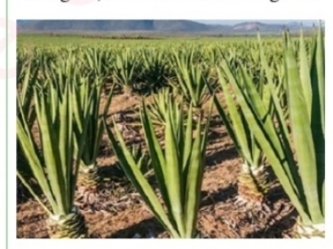
- Study the following photograph and answer a question that follows.
- With two (2) evidence, name the type of photograph
- What is the name of dominant vegetation shown on photographed area?
- With one evidence from the photograph, suggest the climate of photographed area
- In three (3) points show how vegetations depicted on the photograph adapt to climatic condition of the area
- Name the feature appearing on the back ground of the photograph and describe the geomorphic process responsible for its formation.
- Study the following table which indicates Electricity generation in giga watts per hour at Kinyerezi power plant in Tanzania from 2016 to 2020
| Source/Year | 2016 | 2017 | 2018 | 2019 | 2020 |
| Hydro-electric power | 1992 | 1769 | 1721 | 2613 | 2124 |
| Gas | 2265 | 2664 | 2872 | 2624 | 2873 |
| Heavy fuel oil | 781 | 1083 | 1133 | 784 | 1188 |
- Draw a multiple bar graph and precisely comment on the graph
- Give two (2) advantage and two (2) disadvantages of using multiple bar graph
- Identify two (2) alternative method which may be used to present statistical information from given table
- Study the map extract of SIKONGE (Sheet 13712) and then answer the questions
- Using the given RF scale, determine the length of the road in Kilometers from grid reference 740829 to grid reference 760881
- Determine the area at the right hand side of northing 800 in km2
- With examples, name two (2) ways used to show height of the land on the mapped area
- Under what climatic region is mapped area found?
- Draw and label eight features of ocean floor
- Explain six (6) challenges facing green tourism
SECTION C. (30 MARKS)
Answer any two (2) questions
- Solar energy is the friendliest source to environment. However it is not harnessed in large quantities on other sources. What might be reasons for the problem and possible solutions give six points
- Tanzania is known to have a conducive and prospective geological environment with abundant potential of mineral deposits. In six (6) points explain the importance of mining sector to economy of Tanzania
- In six points, explain factors affecting soil formation in Ngara District.
LEARNINGHUBTZ.CO.TZFORM THREE GEOGRAPHY MODAL SERIES 39
THE PRESIDENT’S OFFICE MINISTRY OF EDUCATION, REGIONAL ADMINISTRATION AND LOCAL GOVERNMENT
COMPETENCY BASED SECONDARY EXAMINATION SERIES
GEOGRAPHY-SEPT 2022
FORM THREE
INSTRUCTIONS
- This paper consists of sections A, B and C with a total of ten (10) question.
- Answer All questions in sections A and B and any two (2) questions from section C.
- Map extract of LINDI is provided
- Cellular phones are NOT allowed in the examination room.
- Write your Examination number on every page of your answer booklet (s)
SECTION A (15 MARKS)
PHYSICAL AND MATHEMATICAL GEOGRAPHY
- For each of the items (i) – (x) choose the correct answer from the given alternatives and write its letter besides the item number.
- Which of the following planets is closest to the sun?
- Earth
- Jupiter
- mars
- Mercury
- Neptune
- Overgrazing in Tanzania can lead to environmental problems. Identify the regions might have been affected by the problem;
- Dodoma, Arusha and Shinyanga
- Morogoro, Dar es salaam and Tanga
- Pwani, Mbeya and Rukwa
- Mwanza , Singida and Tabora
- Manyara , Iringa and Dodoma
- when the moon’s shadow casts over the earth’s surface the phenomenon is known as
- Lunar eclipse
- Solar eclipse
- Equinoxes
- Summer solstice
- Winter solstice
- What are the four types of statistical data basing on their nature?
- Individual data, discrete data, raw data and secondary data
- Individual data, discrete data , grouped data and continuous data
- Primary data, secondary data, grouped data and collective data
- Individual data, grouped data, statistical data and discrete data
- Raw data, continuous data , primary data and array data
- The Earth have different evidences that proves that the Earth is spherical. What do you think that this is one among those evidences?
- The four seasons
- The lunar eclipse
- The revolution of the Earth
- The Earth rotation
- The eclipse of the sun
- A drainage pattern which works like a tree with its branches is called
- Radial
- Dendritic
- Centripetal
- Annual
- Trells
- The following arc the element of weather
- Soils, clouds, dew, humidity, rainfall
- Pressure, clouds, sunshine, humidity, winds
- Fog, barometer, humidity, pressure, air mass
- Pressure, humidity, soil, fog, rainfall
- Clouds, sunshine, pressure, humidity, thermometer
- The process of peeling off of rock mass is called
- Disintegration
- Weathering
- Mass wasting
- Erosion
- Exfoliation
- A vertical feature formed out of the solidification of magma within the Earth's crust is called
- Localita
- sill
- lopolith
- Dykc
- Phacolith
- Mrs Kilua was wondering how fragments are worn out during collision against each other at Kondoa river during rainy season, her daughter tells her that process is known as ……
- Hydraulic action
- Attrition
- Abrasion
- Corrosion
- Hydrolysis
- Match the items in List A with responses in List B by writing the letter of the correct response beside the item number in the answer booklet provided.
| LIST A | LIST B |
|
|
SECTION B 55 MARKS
Answer all questions in this section
3. Carefully study the map extract of Kigoma (sheet 92/3) provided and answer the following questions;
(a) Identity the features that found in the following grid references
- 923617
- 945599
- 910596
(b) Calculate the area of lake Tanganyika from 570 Southward. Give your answer in Km2
(c) What is the length of the railway line from grid reference 944633 Eastward. Give your answer in Km.
(d) With evidence suggest the type of settlement patterns depicted in the map.
(e) By providing evidences, explain three (3) human economic activities and two (2) social activities that might be taking place in the area.
4. Study carefully the data below that show the enrollment of form six students at Bagamoyo secondary school from 1980-1985 the answer the questions that follows;
| YEAR | NUMBER |
| 1980 1981 1982 1983 1984 1985 | 100 150 175 200 225 300 |
a) Present the data above by pie chart
b) Comment on the trend of the pie chart in (a) above
c) What are the merits of using this method Apart from that method use in (a) above. Give three (3) points
d) What are alternative methods that can be used to present the data above? Give two (2) points.
5 (a) Mary is a good cartographer; she intends to produce a contoured map of Morogoro. What type of survey method would you advise her to apply?
(b) Apart from producing contour maps, what is the other significance of the survey you have mentioned in (a) above
(c) Mention and explain uses of any three instruments which are used in method you mentioned in (a) above
6. Most of the students usually get confusion when they are trying to differentiate some terms. As a form three student how can help those students to attempt for the following?
a) Small holder farmers and subsistence farming
b) Connate water and juvenile water
c) Adit mining and panning method
d) Footloose industries and industrial inertia
e) Shooting star and meteorite
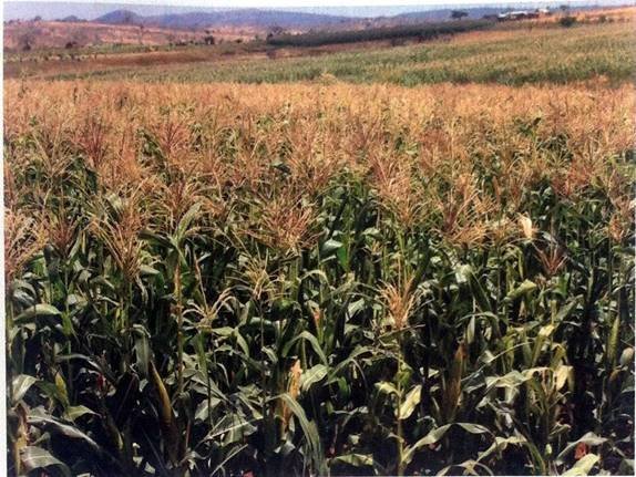
7. Study carefully the given photograph below then answer the questions that follow
- What is the type of the photograph?
- State the scale of the production
- Outline any four regions in Tanzania where the photograph might have been taken
- What are the three necessary conditions that favour the growth of the crop shown on the photograph above?
- List down any four uses of the crop shown on the photograph
SECTION C (30 MARKS)
Answer any two questions in this section
8. a) An announcement from the ministry concerning with industries directed that, government police may play a great role in determining the location of industries, hence the minister argued that, ‘we discourage the concentration of industries in one place” what are the reasons led a minister to argue so? Four points
b) East Africa is struggling to establish several industries so as to fasten the growth of economy. Thus different types of manufacturing industries have been introduced, as an expert in manufacturing, industries identify groups of manufacturing industries in the region concern. Give six groups with vivid examples
9. Plantation is the most form of agriculture practiced in tropical region of Africa, Asia and South America. Justify six (6) characteristics of plantation practiced in these areas.
10. Explain any six objectives of constructing the striglers gorge of hydro-electric power in Tanzania.
LEARNINGHUBTZ.CO.TZFORM THREE GEOGRAPHY MODAL SERIES 28
THE PRESIDENT'S OFFICE
MINISTRY OF REGIONAL GOVERNMENT AND LOCAL GOVERNMENT
AUGUST-SEPTEMBER EXAMINATION SERIES
GEOGRAPHY FORM-3
2020
TIME: 2:30 HRS
Instructions
- This paper consists of sections A, B and C with a total of ten (10) questions.
- Answer all questions in sections A and B and any two (2) questions from section C.
- Map extract of Mkomazi (Sheet 109/1) is provided.
- Programmable calculators, cellular phones and unauthorised materials are not allowed in the examination room.
- Write your Examination Number on every page of your answer booklet(s).
SECTION A (15 Marks)
Answer all questions in this section.
1. For each of the items (i) — (x), choose the correct answer from among the given alternatives and write its letter besides the item number in the answer booklet provided.
(i) Which of the following layers of the earths interior is made up of sima and sial?
- Biosphere
- Hydrosphere
- Asthenosphere
- Lithosphere
- Barysphere
(ii) You are asked to help a Form Two student who failed to identify the types of forests found in the area with low temperatures. What type of forest will you suggest among the following?
- Tropical rain forest
- Coniferous forest
- Equatorial forest
- Deciduous forest
- Mediterranean forest
(iii) What is the social-economic advantage of reserved forests to societies?
- Tourism
- Lumbering
- Mining
- Forestry
- Agriculture
(iv) Which of the following instrument is used to measure maximum and minimum temperature?
- Barometer
- Thermometer
- Anemometer
- Sixs thermometer
- Hydrometer.
(v) Which among the following is an extrusive volcanic feature?
- Crater
- Laccolith
- Batholith
- Sills
- Dykes.
(vi) A region which consists of thick forests, tree dwellers and people who engage in cultivation of rubber, cocoa, bananas and oil palms is known as
- Tropical savanna
- Tropical monsoon
- Polar climate
- Mediterranean
- Equatorial.
(vii)Which of the following is not a process for chemical weathering?
- Carbonation
- Saltation
- Hydrolysis
- Hydration
- Oxidation.
(vii) Which among the following features are produced by wave erosion?
- A Geo, wave cut platform and stack
- Blow hole, sea arch and levee
- Sea arch, beach and stump
- Beach, spit and bars.
- Tombolo, meander and cliff.
(ix) The process through which rain water enters the ground is called
- Evaporation
- Infiltration
- Transpiration
- Condensation
- Percolation.
(x)The process of peeling off and falling of rock mass is called
- disintegration
- weathering
- mass wasting
- erosion
- exfoliation.
2. Match the process involved in the formation of rocks in with the type of rock in List B by writing the letter of the correct response beside the item number in the answer booklet provided.
| LIST A | LIST B |
|
|
SECTION B (55 Marks)
Answer all questions in this section.
4. Carefully study the map extract of Arusha (Sheet 55/3) provided then answers the questions that follow.
- Describe the relief of the mapped area.
(b) Giving evidences, mention the major means of transport shown in a map.
(c) Change the scale of the map into a statement scale.
(d) Measure the length of the road from grid reference 378314 to grid reference 480276 in kilometres.
(e) With evidence from the map, identify three social services which are found in this area.
4. (a) Define compound bar graph.
(b) Study carefully the table below on hypothetical data about cash crops production (in ‘000 tonnes) in East Africa in the year 2000, then answer the questions that follow. Find this
| Country | Crops |
| |
| Coffee | Tea | Cotton | |
| Kenya | 2200 | 2000 | 1800 |
| Uganda | 1700 | 700 | 800 |
| Tanzania | 1300 | 1900 | 2300 |
(i) Draw compound bar graphs to represent the data provided.
(ii) Outline four merits of using compound bar graph.
5. (a) Explain two major forms of measurements in land surveying.
(b) (i) Define leveling.
(ii) Explain four significances of leveling.
6. (a) What is an earthquake?
(b) Briefly explain five effects of earthquakes.
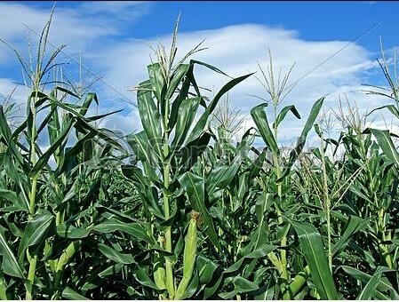
7. Carefully study the photograph given below then answer the questions that follow:
(a) Name the type of photograph.
(b) Describe the relief of the area.
(c) Giving two reasons, describe the scale of production of the crop in the photograph.
(d) Explain two uses of the crop in the photograph.
(e) Describe three conditions necessary for the production of the crop.
SECTION C (30 Marks)
Answer two (2) questions from this section.
8. Give five reasons for decreasing death rates in many parts of the world.
9. Explain eight characteristics of shifting cultivation.
10. Describe six problems facing railway transportation in East Africa.
LEARNINGHUBTZ.CO.TZFORM THREE GEOGRAPHY MODAL SERIES 23
LEARNING HUB.TZ
GEOGRAPHY EXAMINATION FORM THREE
ANNUAL
NAME…………………………………………..CLASS……………………………TIME: 2HRS
INSTRUCTIONS:-
- This paper consists of three sections- A, B and C.
- Answer all questions in section A and B, but only ONE question in section C.
- Write in blue/black pen and drawing using pencil.
- All answers must be written in the spaces provided in each question.
SECTION A:
PHYSICAL AND MATHEMATICAL GEOGRAPHY:
1. For each of the items i-x choose the correct answer from among the given alternatives and write its letter behind the item number.
(i) Autumn, winter, spring and summer are the result of:-
(a) Monsoon
(b) Lunar eclipse
(c) Rotation
(d) Revolution
(e) Tides
(ii) Which of the following is not a factor influencing temperature of a place?
(a) Aspect
(b) Ocean current
(c) Altitude
(d) Eclipse
(e) Length of a day
(iii) Which among the following features is the impact of water action in the desert?
(a) Yardang
(b) Gullies
(c) Bad lands
(d) Sinkholes
(e) Rock pedestals
(iv) What is the direction of 22![]() ?
?
(a) SES
(b) NEN
(c) NWN
(d) SWS
(e) None of the above
(v) Which of the following is formed due to depositional features of the river?
(a) Water fall
(b) Delta
(c) Hanging Valley
(d) Tombolo
(e) Cirque
(vi) The maximum and minimum temperature are obtained from an instrument called?
(a) A barometer
(b) A Six’s thermometer
(c) An anemometer
(d) Kilometer
(vii) The solar system is made up of:-
(a) Sun, planets and interplanetary gases
(b) Atmosphere and hydrosphere
(c) Planets, clouds and gases
(d) Hydrosphere, atmosphere and clouds
(viii) A delta which is formed in a lake is called ………delta
(a) Moraine
(b) Laustrine
(c) Alluvial
(d) Acute
(e) Cuspate
(ix) What is the compass bearing of WNW?
(a) 27![]()
(b) 33![]()
(c) 31![]()
(d) 32![]()
(e) 292.![]()
(x) Destruction, wastage and removal of parts of the earth’s surface;
(a) Denudation
(b) Frost action
(c) Exfoliation
(d) Deposition
2. Match the items in LIST “A” with the responses in LIST B
| LIST A | LIST B |
|
|
SECTION B
3. (a) What is meant by Moraine erosion?
(b) Describe four (4) processes which are involved in Moraine erosion.(5marks)
4. Study the data in the following table and answer the questions that follow.
ENVIRONMENTAL WORKERS IN TEN STREETS OF ARUSHA CITY.
| STEET | A | B | C | D | E | F | G | H | I | J |
| NUMBER OF WORKERS | 12 | 06 | 20 | 03 | 12 | 02 | 12 | 03 | 18 | 09 |
(a) Find the range of workers in this city.
(b) Calculate the (i) Mean (ii) Median (iii) Mode of these workers.
(c) Calculate variance and standard deviation of the workers.
5. Carefully study the map extract of Arusha (sheet 55/3) provided then answer the questions that follows.
(a) Describe the relief of the mapped area
(b) Giving evidences, mention the major means of transport shown in a map.
(c) Change the scale of the map into a statement scale
(d) Measure the length of the road from grid reference 378314to grid reference 480276 in Kilometers.
(e) With evidence from the map identify three social services which are found in this area.
6. Study carefully photograph provided then answer the questions that follows.
(a) Suggest the title of photograph
(b) (i) Name the type of forest seen in the photograph
(ii) Give two characteristics of the forest named in (i)
(c) Outline three ways of interpreting the photograph given
(d) (i) Identify the product in the middle ground of the photograph
(ii) Give two uses of the product in the middle ground of the photograph.
SECTION B:
Answer only one question in this part.
7. Explain seven ways of improving tourism Industry in Tanzania.
8. Elaborate the problems hindering development of agriculture sector in Tanzania.
LEARNINGHUBTZ.COM.TZ Page 1
LEARNINGHUBTZ.CO.TZFORM THREE GEOGRAPHY MODAL SERIES 11
LEARNING HUB TANZANIA
FORM THREE GEOGRAPHY ANNUAL EXAM
NAME………………………………………………………………STREAM………………………………
TIME: 2:30HRS SUBJECT GEOGRAPHY
ISTRUCTIONS
. This paper consists of four section A, B, and C.
. Answer al questions in section A, and B . Choose one answer to questions in section C .
. Observe good arrangement of work
SECTION A: (25 MARKS)
PHYSICAL AND MATHEMATICAL GEOGRAPHY
- i. Earthquake begins;
- Along a fault or a fissure
- At the inner core of the earth
- At the epicenter
- At the focus
- From the mantle
ii. Which one of the following is characterized by receiving rainfall throughout the year
- Tropical climate
- Mediterranean climate
- Tropical monsoon
- Equatorial climate
- Hot desert
iii. Igneous rock;
- Are hard and non stratified
- Contain fossils
- Are formed when one type of rock change into another type of rocks
- Occur in layers
- Are soft rock
iv. Which one of the following do not support mass wasting
- Forest fires
- Steep slope
- Heavy rainfall
- Human activity
- Wind
v. What is the dominant force that cause mass wasting
A. Gravity
B. seismic energy release
C. Force of water
D. Glacial
E. Tidal force
vi. The formation of the river delta involves the following process
- Transportation, corrosion, deposition
- Deposition, erosion, transportation
- Deposition, transportation, abrasion
- Saltation, suspension, solution
- Hydraulic action, attrition, deposition
vii. The erosive power of the river depend upon its ;
- Width and depth
- Speed and depth
- Gradient and width
- Speed and volume
- Speed and width
viii. Rolling of large pieces of materials from one place to place
- Attrition
- Traction
- Suspension
- Solution
- Abrasion
ix. Which scale is the largest?
- 1:1000000
- 1:10000
- 1:50000
- 1:30000
- 1:100000
x. Which one is the feature formed due to river rejuvenation among the
A. Elbow
B. Landslide
C. Rock fall
D. Interlocking spurs
E. Knick point
| i | ii | Iii | Iv | v | Vi | Vii | viii | ix | X |
|
|
|
|
|
|
|
|
|
|
|
- MATCH THE ITEM FOUND IN TABLE A WITH THAT OF TABLE B
| TABLE A | TABLE B |
|
|
| i. | ii. | iii. | iv. | v. |
|
|
|
|
|
|
- With the aid of diagram describe the following geographical features
- Arcute delta
- Cuspate delta
- Ox-bow lake
- Water falls
- Pot holes
SECTION B: (55 MARKS)
APPLICATION OF STATISTIC AND ELEMENTARY SURVEY
- Contribution of agriculture to the Gross Domestic Product (GDP) in East Africa in percentage
| Year/country | TANZANIA | KENYA | UGANDA |
| 2002 | 64 | 47 | 67 |
| 2003 | 59 | 42 | 64 |
| 2004 | 61 | 40 | 61 |
| 2005 | 54 | 38 | 59 |
- Draw the comparative bar graph to present above information( 5 marks)
- Comment on the contribution of agriculture to the economy of these countries( 2 marks)
- State 2 advantage and 2 dis- advantage of comparative bar graph( 4 marks)
5. a. Analyze the procedure for conducting survey( 4 marks)
b. mention types of error in chain survey( 3 marks)
c. by the use of diagram explain about four equipments used in chain survey( 5 marks)
MAP READING AND PHOTOGRAPHY INTERPRETATION
6. Study carefully the map extract of KASAMWA sheet number32/4 and then answer the questions that follow;
a. Change the scale of the map into
i. Representative fraction
ii. Statement scale
iii. Linear scale
b. Calculate the vertical exaggeration of the given map
c. Mention at least three ways in which the cartographer used to present relief of the given map
d. Calculate the area covered by seasonal swap
e. With clear evidence suggest 2 social activities and 2 economic activities conducted in the map given
f. Periodize the map given. (11 marks)
7. Study the photo given and answer the question below
a. What is the type of photograph does the picture present?(2 marks)
b. State 3 characteristic of the type of photograph in (a) above( 3 marks)
c. Mention two economic contribution of the crop shown ( 2 marks)
d. Mention at least 2 uses of the crop shown in the photograph ( 2 marks)
e. Mention the country in the world which is famous in the growing of the crop above ( 2 marks)
SECTION C (30 marks)
REGIONAL FOCAL STUDY AND ENVIROMENTAL ISSUES
8. Describe the contribution of Serengeti National Park to our country
9. Explain the main factors which have influenced the ship industry in Japan
11. “Leaching process is the only source of land degradation”. Discuss
LEARNINGHUBTZ.CO.TZFORM THREE GEOGRAPHY MODAL SERIES 10

 For Call,Sms&WhatsApp: 255769929722 / 255754805256
For Call,Sms&WhatsApp: 255769929722 / 255754805256 


