THE UNITED REPUBLIC OF TANZANIA NATIONAL EXAMINATIONS COUNCIL OF TANZANIA CERTIFICATE OF SECONDARY EDUCATION EXAMINATION
013 GEOGRAPHY
(For Both School and Private Candidates)
Time: 3:00 Hours Year:2024
Instructions
This paper consists of sections A, B and C with a total of eleven (11) questions.
Answer all questions in sections A and B and two (2) questions from section C.
Section A carries sixteen (16) marks, section B fifty four (54) marks and section C carries thirty (30) marks.
All writing must be in blue or black ink except drawing which must be in pencil.
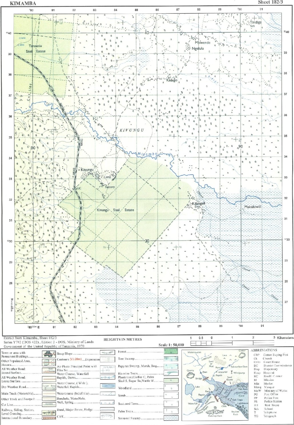
Map extract of Kimamba (Sheet 182/3) is provided.
6. Programmable calculators, communication devices and any unauthorised materials are not allowed in the examination room.
Write your Examination Number on every page of your answer booklet(s).
SECTION A (16 Marks)
Answer all questions in this section.
l . For each of the items (i) — (x), choose the correct answer from the given alternatives and write its letter beside the item number in the answer booklet(s) provided.
(i) During the night, Mayoo saw a bright object lighting crossing the sky at high speed. Identify the object seen by Mayoo.
Meteors
Satellites
Planets
Asteroids
Comets
Choose Answer :
(ii) Abel keeps records of linear measurements, heights and angles on the earth's surface during surveying. Who is Abel?
Cartographer
Booker
Leader
Chain man
Follower
Choose Answer :
(iii) A businessman wants to transport bulky goods from Dar es Salaam to Kigoma. Suggest the best mode of transport that he can use.
Air
Railway
Water
Pipeline
Cable
Choose Answer :
(iv) Gold deposits which are near to the surface have been discovered at Mtakuja village, What could be the suitable method in extracting them?
Shaft mining
Underground mining
Open cast mining
Alluvial mining
Placer mining
Choose Answer :
(v) Jaka is living in Dar es Salaam city centre where houses are clustered together. What could be the main environmental problem in the area?
Loss of biodiversity
Deforestation
Soil erosion
Desertification
Pollution
Choose Answer :
(vi) What is the local time in Burundi which is located at 290 E when it is 06:00 am in Brazzaville which is located at 140 E?
1100 pm
01: 00 am
07:00 am
11:00 am
10: 00 am
Choose Answer :
(vii) Miss Shengo uses energy generated from the sun for cooking. Identify the type of energy she is using.
Nuclear energy
Wind energy
Geothermal energy
Solar energy
Biogas energy
Choose Answer :
(viii) Which is the main characteristic of the Earth's crust?
It is the thickest layer of the Earth
It is the outer layer of the Earth
It is the middle layer of the Earth
It is the molten layer of the Earth
It is the hottest layer of the Earth
Choose Answer :
(ix) Pita was asked by his teacher to identify components of soil in a farm. Which among the following components will be identified?
Organic matter, inorganic matter, water and air
Inorganic matter, minerals, trees and earthworms
Water, air, living organisms and plants
Parental rocks, climate, water and organisms
Rocks, minerals, water and gases
Choose Answer :
(x) Mr. Kanjubai established school bags industry near Kanjubai Primary and Secondary schools. Identify the main factor for locating that industry in the area.
Capital
Labour force
Power supply
Market
Raw material
Choose Answer :
2. Match the climatic region in List A with their corresponding areas in the world in List B by writing a letter of the correct response beside the item number in the answer booklet provided.
3. Study carefully the map extract of Kimamba (sheet 182/3) provided and then answer the following questions:
(a) Suppose a hunter was standing at Tindiga school compound at grid reference 907406 and he saw an antelope at grid reference 870380. Locate the position of an antelope by using bearing.
(b) Identify the stage of development reached by the main river in the map.
(c). Briefly describe the distribution of vegetation in the mapped area. Give two points.
(d) Classify three settlement patterns of the mapped area.
10. Formation of features on the Earth's surface is a result of forces that originates and operates either within or on the Earth's surface. Describe five forces responsible for the formation of those features.


 For Call,Sms&WhatsApp: 255769929722 / 255754805256
 RATIBA NECTA KIDATO CHA IV 2026


