THE UNITED REPUBLIC OF TANZANIA NATIONAL EXAMINATIONS COUNCIL OF TANZANIA CERTIFICATE OF SECONDARY EDUCATION EXAMINATION
013 GEOGRAPHY
(For Both School and Private Candidates)
Time: 3 HoursYear: 2021
Instructions
This paper consists of sections A, B and C with a total of ten (10) questions.
Answer all questions in section A and B and two (2) questions from section C.
Section A carries fifteen (15) marks, section B fifty five (55) marks and section C carries thirty (30) marks.
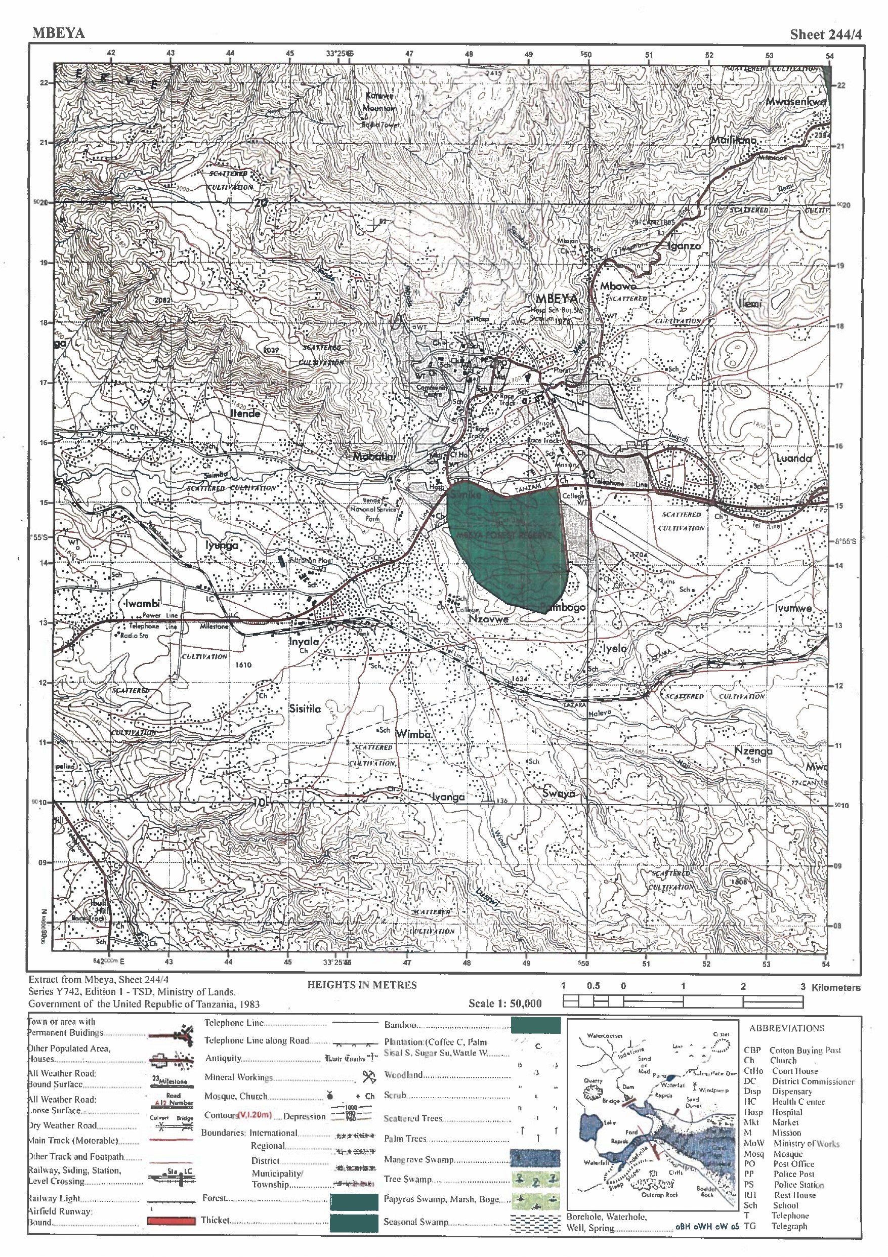
Map extract of Mbeya (Sheet 244/4) is provided.
Programmable Calculators, Cellular phones and any unauthorised materials are not allowed in the examination room.
Write your Examination Number on every page of your answer booklet(s).
SECTION A (15 Marks) Answer all questions in this section.
1. For each of the items (i) - (x), choose the correct answer from among the given alternatives and write its letter in the answer booklet(s) provided.
(i) The solar system is made up of the sun, planets and other heavenly bodies which revolve around the sun. Which planet has the shortest orbit?
Pluto
Mercury
Mars
Earth
Venus
Choose Answer :
(ii) Asha was observing the uniform removal of top thin layer of the soil by running water in the rainy day. What type of soil removal was she observing?
Splash erosion
Gully erosion
Sheet erosion
Rill erosion
Wind erosion
Choose Answer :
(iii) Tanzanian population structure is concave in shape. What is the implication of this shape?
Birth rate is high, low life expectancy and high death rate
Low birth rate, high life expectancy and stable growth rate
Birth rate is high, high infant mortality and high death rate
Birth rate is low, low infant mortality and high death rate
Birth rate is high, high life expectancy and stable growth rate
Choose Answer :
(iv) Form One students were watching a Television program on various human activities in Maisha village. Which among the observed activities is not the cause of environmental destruction in that Village?
Afforestation
Charcoal burning
Lumbering
Fire wood cutting
Construction activities
Choose Answer :
(v) Maneno's village has rainfall throughout the year and is surrounded by dense forest. Which type of forest do you think could be found in his village?
Mangrove forest
Coniferous forest
Tropical forest
Temperate forest
Semi-arid forest
Choose Answer :
(vi) What is the main cause of time variation between Lamu 40°E and Tunis 10°E?
Rotation of the earth
Differences in longitudes
Revolution of the earth
Rotation and revolution
Differences in latitudes
Choose Answer :
(vii) Form Three students were taught that, the Southern Tourist Circuit in Tanzania promotes ecotourism. Which of the following is not encouraged in the promotion of ecotourism in the area?
Afforestation
Protecting endangered species
Coastal attraction
Environmental conservation
Discouraging forest fire
Choose Answer :
(viii) Which one is a factor that affects temperature between Tanzania and Netherlands?
Altitude
Solar system
The sun
Solar energy
Heavenly bodies
Choose Answer :
(ix) It is observed that, there is mineral exhaustion in Kahama district and the production is very minimal. Which one is the best alternative economic activity that can be adopted by the people living in the area so as to improve the standard of their life?
Improving methods of extraction
Reducing population
Reclaiming the affected areas for agriculture
Developing other sources of energy
Establishing industries
Choose Answer :
(x) The owner of a plastic industry ordered the management to use environmental friendly energy sources in production. Which energy source could be used in that industry?
Petroleum
Nuclear
Fuel wood
Coal
Solar
Choose Answer :
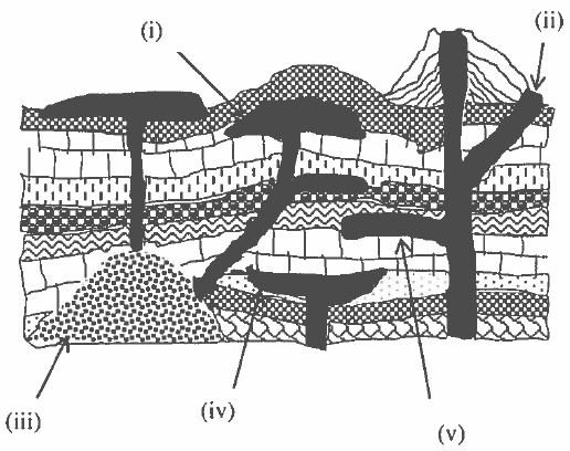
2. Match the intrusive volcanic features in List A with their corresponding relevant names in List B by writing a letter of the correct response beside the item roman number in the answer booklet provided.
4.The form One students carried a study tour to Hale Hydroelectric Power Station where they observed falling water in a river course disturbed by a steep flow of water which cause the water wheel to rotate.
Name the feature with steep gradient the students observed.
Describe the feature named in (a).
With the aid of a diagram, describe how the feature named in (a) can be formed where a layer of resistant rock lies horizontally across a river channel.
6.Assume you are a chain surveyor expert in one of the village and you have been assigned a task of measuring a distance of a river from point A to point B.
Which seven steps will you follow to carry out such a task?
How would you ensure the correctness of measurement as you carry out a task?
8. The Form Four students had a field study to the National Bureau of Statistics. In the site, the statistician explained to them about different concepts of statistics and their benefits to users. Describe five benefits of statistics that might have been explained by the statistician.
9. Mdariani is a village surrounded by different types of rocks. Suppose you have been invited by the villagers to educate them about the sedimentary rocks and their characteristics, what six features would you give them as a guide?
10. "River basin development project is essential to economic development of various countries of the world". In six points, explain the importances of the project to the economy of Tanzania.

 For Call,Sms&WhatsApp: 255769929722 / 255754805256
 MATOKEO YA KIDATO CHA VI 2026


