THE UNITED REPUBLIC OF TANZANIA NATIONAL EXAMINATIONS COUNCIL OF TANZANIA CERTIFICATE OF SECONDARY EDUCATION EXAMINATION
013GEOGRAPHY
(For Both School and Private Candidates)
Time: 3 HoursTuesday, 06th November 2018 p.m.
Instructions
This paper consists of sections A, B, C and D with a total of twelve (12) questions.
Answer all questions in section A, B and C and one (1) question from each part of section D.
Map extract of Ilonga (Sheet 265/2) is provided.
Calculators, cellular phones and any unauthorized materials are not allowed in the examination room.
SECTION A (25 Marks) Answer all questions in this section. PHYSICAL AND MATHEMATICAL GEOGRAPHY
1. For each of the items (i) (x), choose the correct answer from among the given alternatives and write its letter besides the item number in the answer booklet provided.
(i)Which of the following instrument is used to measure maximum and minimum temperature?
Barometer
Thermometer
Anemometer
Sixs thermometer
Hydrometer.
Choose Answer :
(ii)Which among the following is an extrusive volcanic feature?
Crater
Laccolith
Batholith
Sills
Dykes.
Choose Answer :
(iii)One of the factors for soil formation is
organic matters
mineral matters.
time.
water.
air.
Choose Answer :
(iv)The layer of the atmosphere which is nearer to the earths surface is called
troposphere
stratosphere
hydrosphere
mesosphere
thermosphere.
Choose Answer :
(v)Which among the following is a heavenly body that possesses and transmits its own light?
Moon
Sun
Earth
Astreroid
Planet.
Choose Answer :
(vi) A region which consists of thick forests, tree dwellers and people who engage in cultivation of rubber, cocoa, bananas and oil palms is known as
Tropical savanna
Tropical monsoon
Polar climate
Mediterranean
Equatorial.
Choose Answer :
(vii) An instrument used to determine Magnetic North is called
Stevenson screen.
Compass.
Thermometer.
Hygrometer
Barometer.
Choose Answer :
(viii)Which of the following is not a process for chemical weathering?
Carbonation
Saltation
Hydrolysis
Hydration
Oxidation.
Choose Answer :
(ix) Which among the following features are produced by wave erosion?
A Geo, wave cut platform and stack
Blow hole, sea arch and levee
Sea arch, beach and stump
Beach, spit and bars.
Tombolo, meander and cliff.
Choose Answer :
(x) If the scale of a map is 1:50,000, what will be the actual ground distance of a river with 18cm on a map?
9 km
2 km
4 km
8 km
1 km.
Choose Answer :
2. Match the process involved in the formation of rocks in with the type of rock in List B by writing the letter of the correct response beside the item number in the answer booklet provided.
LIST A
LIST B
Rocks formed when magma solidifies deep in the crust and can be exposed on the surface by agents of erosion.
Rocks formed when molten magma cools and solidifies inside the rocks of the earth or on the surface of the earth.
Rocks formed as results of deposition and compaction of remains of dead plants and animals.
Rocks formed when different types of rocks are subjected to great heat and pressure.
Rocks formed when sediments are deposited either by water, wind or ice
SECTION B (27 Marks) Answer all questions in this section.
APPLICATION OF STATISTICS, INTRODUCTION TO RESEARCH AND ELEMENTARY SURVEYING
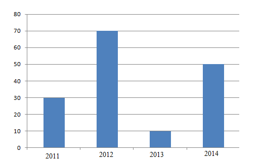
Carefully study the following statistical graph showing coffee production (in tonnes) in Tanzania, from 2011 to 2014 and answer the questions that follows

 For Call,Sms&WhatsApp: 255769929722 / 255754805256
 MATOKEO YA KIDATO CHA VI 2026


