2. Answer all questions in sections A, B and C and one(1) question from each part of section D.
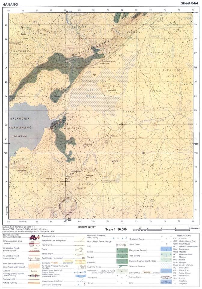
3. Map extract of Hanang (Sheet 84/4) is provided.
4. Calculators and Cellular phones are not allowed in the examination room.
5. Write your ExaminationNumber on every page of your answer booklet(s)
SECTIONA(25Marks)
Answer all questions in this section.
PHYSICAL AND MATHEMATICAL GEOGRAPHY
1. For e ach o f the i tems ( i) - ( x), c hoose t he correct answer from among the g iven a lternatives and write its letter in the a nswer booklet provided.
(i) The speed of the earth quake waves i n t he earth is c hanged at a line called
Mohorovic discontinuity
Gutenberg discontinuity
Tectonics
Tectonics
Isostatic.
Choose Answer :
(ii) Liverpool team scored a goal at 5.00 pm in England (15° W). At what time the goal was scored in Dar es Salaam (45° E)?
1.00 p.m
7.00 p.m
9.45 p.m
9.00 p.m
6.30 a.m.
Choose Answer :
(iii) The sun is overhead attropic of Capricorn every year on
22nd December
21stMarch
23rd September
21st June
24thMarch.
(iv)Day reaches its maximum length on 21st June in
Southern hemisphere
Northern Hemisphere
Arctic Circle
Polar region
Tropic of Capricorn.
Choose Answer :
(iii) The sun is overhead attropic of Capricorn every year on
22nd December
21stMarch
23rd September
21st June
24thMarch.
(iv)Day reaches its maximum length on 21st June in
Southern hemisphere
Northern Hemisphere
Arctic Circle
Polar region
Tropic of Capricorn.
Choose Answer :
(v) Which of the following planets have small celestial bodies in orbit a round them?
Mercury, Jupiter and Uranus
Pluto, Earth a nd Mars
Earth, Jupiter and Saturn
Mercury, Venus and Earth
Venus, Earth and Saturn.
Choose Answer :
(vi) Deposition of soil materials removed from one horizon to another is called
Convex sided
Concave sided
Gentle sided resistance
Steep sided resistant
Steep sided non resistance.
Choose Answer :
(vii) The excessive strong wind blowing across an extensive ocean surface is called
Tsunami
Ocean currents
Storm s urge
Hurricane
Wind.
Choose Answer :
(ix) Rainfall that occurs when the air moves towards a hill or a mountain is called
cyclonic
orographic
convectional
showers
typhoon.
Choose Answer :
(x) Mountains can be classified on the basis o f
their importance
their s urrounding
their c omposition
their formation
their height.
Choose Answer :
(x) A channel diverging from the main river a nd flowing into the sea or a lake by a separate mouth is called
tributary
stream
distributary
river basin
water shade.
Choose Answer :
p>2. Match the items in List A with the responses in List B by writing the letter of the correct response b esides t he i tem number i n t he answer b ooklet provided.
LIST A
LIST B
Water that flows out of the ground.
Water that seep out of rocks and into the rock holes.
Water that enters the rocks of the earth’s surface.
Interaction of water v apour, p recipitation, i nfiltration, r un off, evaporation and condensation.

 For Call,Sms&WhatsApp: 255769929722 / 255754805256
 MATOKEO YA KIDATO CHA VI 2026


