THE UNITED REPUBLIC OF TANZANIA
NATIONAL EXAMINATIONS COUNCIL CERTIFICATE OF SECONDARY EDUCATION EXAMINATION
013 GEOGRAPHY
(For School Candidates Only)
Time: 3 Hours Monday, 04 th November 2013 a.m.
Instructions
1. This paper consists of sections A, B, C and D.
2. Answer all questions in sections A, B and C and one (1) question from each part of section D.
3. Map extract of Kigoma (Series Y742 sheet 92/3) is provided.
4. Credit will be given for the use of relevant sketch maps and diagrams.
5. Calculators and cellular phones are not allowed in the examination room.
6. Write your Examination Number on every page of your answer booklet(s)
SECTION A (25 Marks)
Answer all questions in this section.
PHYSICAL AND MATHEMATICAL GEOGRAPHY
1. For each of the items (i) - (x), choose the correct answer from among the given alternatives and write its letter beside the item number.
(i) A cirque is
an arm-chair shaped depression on a glaciated lowland area an arm-chair shaped depression on the sides of a glaciated mountain an arm-chair shaped depression in the desert areas an arm-chair shaped valley in glaciated areas an arm-chair shaped depression on the plateau. Choose Answer :
- -
A
B
C
D
E
(ii) A geyser can be described as
a hot spring an explosion of volcanic vapour a fountain of superheated water and steam a thermal stream a pool of hot water. Choose Answer :
- -
A
B
C
D
E
(iii) Which one of the following conditions is important for the growth of coral reefs?
Warm and muddy river water Warm and muddy sea water Warm and clear sea water Warm and clear tape water Warm and clear river water. Choose Answer :
- -
A
B
C
D
E
(iv) A time accepted throughout a time zone of 15° longitude is known as
local time noon time greenwich mean time sun time standard time. Choose Answer :
- -
A
B
C
D
E
(v) Which sequence of the following processes is necessary for the formation of rainfall?
Condensation, cooling and evaporation Evaporation, cooling and condensation Evaporation, sedimentation and cooling Evaporation, condensation and cooling Evaporation, cooling and sedimentation. Choose Answer :
- -
A
B
C
D
E
(vi) Which of the following instruments is used to measure pressure?
Wet and dry bulb thermometer Aneroid barometer Anemometer Rain gauge Hygrometer. Choose Answer :
- -
A
B
C
D
E
(vii) Faulting may lead to the formation of
rift valleys moraines ox-bow lakes boulder clays yardangs. Choose Answer :
- -
A
B
C
D
E
(viii) Which of the following statements is true to an equatorial region?
It has a small annual range of temperature It has four rainfall maxima It experiences temperatures below 20°C It has a high annual range of temperature It is found between 15° and 30° north and south of the equator. Choose Answer :
- -
A
B
C
D
E
(ix) The earth’s crust is also known as
atmosphere hydrosphere mantle lithosphere troposphere. Choose Answer :
- -
A
B
C
D
E
(x) What is the compass bearing of WNW?
270° 337° 315° 327° 292° Choose Answer :
- -
A
B
C
D
E
2. Match the items in List A with the responses in List B by writing the letter of the correct response beside the item number.
LIST A LIST B (i) A tidal wave formed as a result of an earthquake or volcanic eruption.
(ii) Denser rocks that form the ocean floor.
(iii) A force that causes the bending of the earth’s crust.
(iv) Intrusive volcanic feature formed horizontally along the bedding plane.
(v) Formed when two caves on opposite sides of headland join up.
Compression Dyke Sial Ocean currents Faulting Arch Sima Tsunami Stack Sill
View Ans 3. With the aid of diagram, explain any five features formed by wave deposition.
View Ans SECTION B (27 Marks)
Answer all questions this section.
APPLICATION OF STATISTICS, INTRODUCTION TO RESEARCH AND ELEMENTARY SURVEYING
4. (a) Explain the meaning of the standard deviation.
View Ans (b) Study the following data showing the age of the Primary School pupils at Tumaini Primary School and answer the questions that follow: 15, 8, 7, 6, 12, 5, 14 and 13.
(i) Determine the range and median of the age of the pupils.
(ii) Calculate the standard deviation.
View Ans 5. (a) What is research?
View Ans (b) Explain four benefits of conducting research.
View Ans 6. (a) Explain the best steps required in order to conduct an accurate chain survey.
View Ans (b) What are the five good booking methods used in chain survey?
View Ans SECTION C (28 Marks)
Answer all questions in this section.
MAP READING AND PHOTOGRAPH INTERPRETATION
7. Study the printed map extract of Kigoma (Series Y742 sheet 92/3), then answer the following questions:
(a) By using the vertical scale of 1cm to 20m, draw a cross section from grid reference 91057 to grid reference 932620 and determine its Vertical Exaggeration (V.E).
(b) With vivid evidence from the map, mention the major types of transport shown in the area.
(c) Apart from fishing activities, use concrete evidence to name other economic activities taking place in the area.
(d) In which hemisphere is the mapped area located? Give evidence for your answer.
View Ans 8. Study the photograph given below and then answer the questions that follow:
(a) Identify the type of photograph. Give concrete evidence
(b) By providing evidence from the photograph, describe the relief of the area.
(c) Explain three possible factors which have contributed to the growth of this town.
(d) Apart from providing shade, explain any other three advantages of the vegetation shown on the photograph.
View Ans SECTION D (20 Marks)
Answer one (1) question from each part.
PART 1: REGIONAL FOCAL STUDIES
9. Explain six factors which account for the development of car manufacturing industry in Japan.
View Ans 10. Describe six problems facing railway transportation in East Africa.
View Ans 11. Elaborate six importance of Mount Kilimanjaro to Tanzania.
View Ans 12. Examine six effects of environmental pollution in African cities.
View Ans 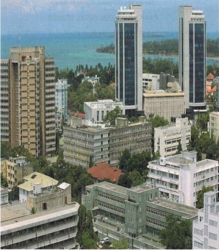

 For Call,Sms&WhatsApp: 255769929722 / 255754805256
 RATIBA NECTA KIDATO CHA IV 2026


