THE UNITED REPUBLIC OF TANZANIA NATIONAL EXAMINATIONS COUNCIL
CERTIFICATE OF SECONDARY EDUCATION EXAMINATION
013 GEOGRAPHY
(For School Candidates Only)
Time:3 Hours Tuesday, 8th October 2009 p.m.
Instructions
1. This paper consists of sections A, B, C and D.
2. Answer all questions in sections A, B and C and one (1) question from each part of section D.
3. Map extract of Galula is provided.
4. Credit will be given for the use of relevant sketch maps and diagrams.
5. Electronic calculators and cellular phones are not allowed in the examination room.
6. Write your Examination Number on every page of your answer booklet(s)
SECTION A (25 Marks)
Answer all questions in this section.
PHYSICAL AND MATHEMATICAL GEOGRAPHY
1. For each of the items (i) - (x), choose the correct answer from among the given alternatives and write its letter beside the item number.
(i) The solar system is made up of
- sun, planets and interplanetary gases
- atmosphere and hydrosphere
- planets, clouds and gases
- clouds, wind and gases
- sunlight, gases, wind and clouds.
Choose Answer :
(ii) If the time recorded at time X, 45°E was 9.00 a.m. what could be the longitude of Y at 3.00 a.m.
- 90°W
- 45°W
- 15°E
- 90°E
- 75°W
Choose Answer :
(iii) Lunar eclipse occurs because
- the moon comes between the earth and the sun
- the earth comes between the moon and the sun
- the earth rotates from west to east
- the sun comes between the moon and the earth
- the moon, the earth and the sun are in rotation.
Choose Answer :
(iv) About 98% of the matter making the sun is
- light and heat
- heavier elements
- tars and other heavenly bodies
- lighter elements of hydrogen and helium
- gases, heat and sun ray.
Choose Answer :
(v) Absence of drainage on the surface in the limestone region is the direct result of
- very low rains in the area
- presence of swallow holes
- the big rivers which swallow small rivers
- presence of deep gorges
- presence of sound and big pores.
Choose Answer :
(vi) The following are marine depositional features:
- Beach, lagoons and sand spits
- Beach, fringing reef and stump
- Beach, stump and atoll
- Tombolo, delta and headland
- Headland, geo and stacks.
Choose Answer :
(vii) Why do two different countries located in different latitudes or hemispheres experience similar type of natural vegetation? It is because of
- their positions which are very far
- similar traditions of the people living in those areas
- the same type of climate
- same onshore prevailing winds
- fertile soils, good could cover and rains.
Choose Answer :
(viii) ………. shows the soil’s grain size.
- Soil texture
- Soil structure
- Soil morphology
- Particle density
- Soil profile
Choose Answer :
(ix) Temperate cyclones are characterized as follows:
- They are instruments with cycles for measuring temperature
- Have long hours of high temperature
- They are temperate winds which have a high speed
- They are low pressure centres which develop in temperate Latitudes
- They are strong temperate rains in the United States of America, Africa and the Congo basin.
Choose Answer :
(x) A vertical cross-section of the soil showing its horizons is called
- soil erosion
- soil porosity
- soil profile
- soil PH
- soil catena.
Choose Answer :
2. Match the items in List A with the responses in List B by writing the letter of the correct response besides the item number.
| List A | List B |
| (i) Intervisibility (ii) A Basin (iii) Glaciers (iv) Denudation (v) Stevenson’s screen | - It determines the distance of a cross-section
- Weather station
- A catchment area of the river
- Ox-bow lake
- One of the sources of a river
- A screen showing precipitation
- Batholiths
- Weathering and erosion
- Movement of the earth
- The ability to see between two given points
|
View Ans
3. With the aid of diagrams, explain the types of moraines.
View Ans
SECTION B (27 Marks)
Answer all questions this section.
APPLICATION OF STATISTICS, INTRODUCTION TO RESEARCH AND ELEMENTARY SURVEYING
4. Read carefully the climatic data for station A presented in the Table and answer the questions that follow:
| Month | J | F | M | A | M | J | J | A | S | O | N | D |
| Temp. in °C | 26.6 | 26.6 | 26.6 | 26.6 | 26.6 | 26.6 | 27.2 | 27.7 | 28.3 | 28.3 | 27.7 | 27.7 |
| Rainfall mm | 233 | 228 | 244 | 215 | 118 | 91 | 36 | 36 | 51 | 104 | 140 | 196 |
(i) Describe the climatic conditions of station A.
(ii) Name any two countries in the Great Lakes of East Africa which experience this type of climatic conditions.
(iii) Present the data graphically.
View Ans
5. (a) What is research design?
(b) Briefly explain any four (4) types of research-design.
View Ans
6. (a) Mary is a good cartographer, she intends to produce a contoured map of Dar es Salaam. What type of survey method would you advise her to apply?
(b) Apart from producing contour maps, what is the other significance of the type of survey you have mentioned in (a) above?
View Ans
SECTION C (28 Marks)
Answer all questions in this section.
MAP READING AND PHOTOGRAPH INTERPRETATION
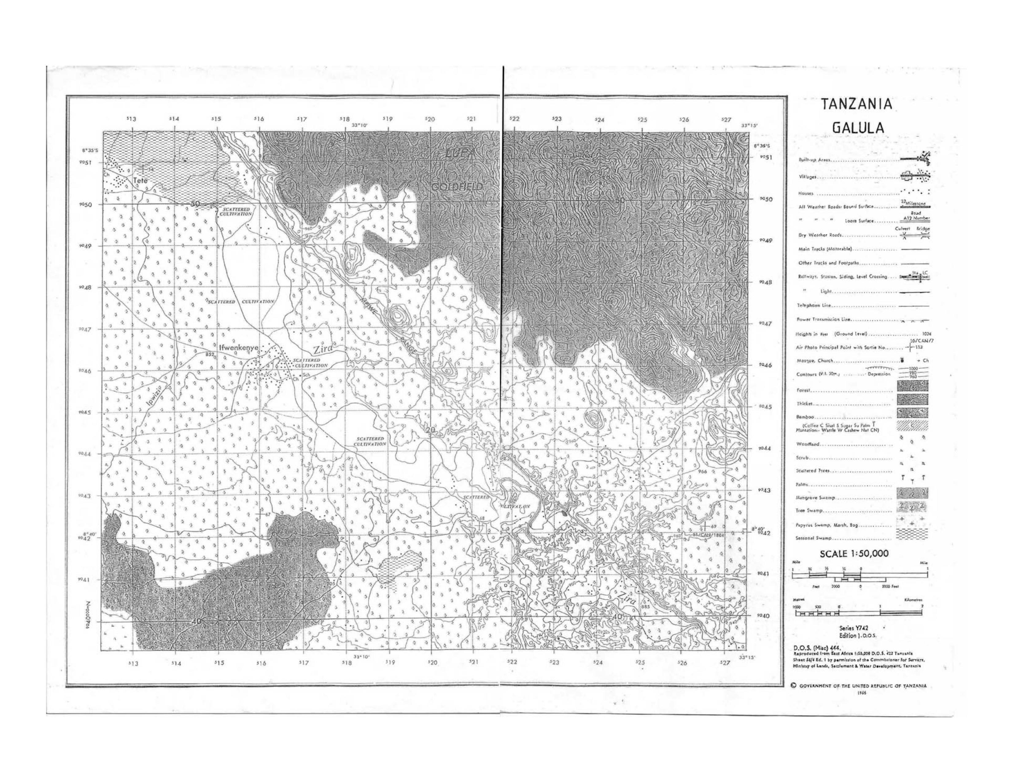
7. Carefully study the map extract of Galula provided then answer the following questions.
(a) Calculate the area of the forest in Km2 north of northings 450.
(b) Calculate the length of River Ipwizi in Kilometres from grid reference 150508 to grid reference 125435.
(c) Find the bearing of Tete Village (grid reference 127506) from Ifwekenye village (grid reference 160460).
(d) Describe the main physical features found in the area.
(e) With evidence, show the main economic activities.
View Ans
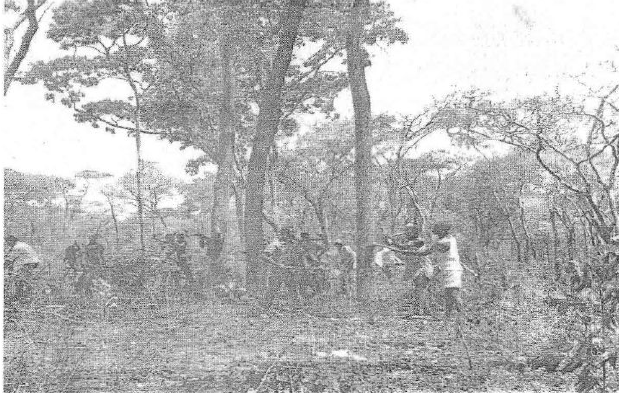
8. Study the photograph provided and then answer the questions that follow.
(i) What type of a photograph is this? Give reasons for your answer
(ii) With evidence, suggest the type of climate of the place where this photograph was taken.
(iii) What kind of activity is taking place in the area?
(iv) What will happen if the activity in (iii) above takes place in your local environment?
View Ans
SECTION D (20 Marks)
Answer one (1) question from each part.
PART 1: REGIONAL FOCAL STUDIES
9. (a) What were the aims of constructing the Aswan High dam?
View Ans
(b) If the dam were constructed at Kondoa, how would the people of central Tanzania benefit from it?
View Ans
10. “Agriculture achievements in China have been brought about by good Government policy only.” Discuss.
View Ans
PART II: ENVIRONMENTAL ISSUES, POPULATION AND SETTLEMENT
11. With vivid examples, explain the causes of population change in the Great lakes of East Africa.
View Ans
12. Some lakes and rivers in Tanzania are likely to lose their aquatic resources. Suggest any five (5) ways on how to overcome this threat.
View Ans

 For Call,Sms&WhatsApp: 255769929722 / 255754805256
 RATIBA NECTA KIDATO CHA IV 2026


