THE UNITED REPUBLIC OF TANZANIA NATIONAL EXAMINATIONS COUNCIL OF TANZANIA CERTIFICATE OF SECONDARY EDUCATION EXAMINATION
013 GEOGRAPHY
(For Both School and Private Candidates)
Time: 3:00 Hours Year:2024
Instructions
- This paper consists of sections A, B and C with a total of eleven (11) questions.
- Answer all questions in sections A and B and two (2) questions from section C.
- Section A carries sixteen (16) marks, section B fifty four (54) marks and section C carries thirty (30) marks.
- All writing must be in blue or black ink except drawing which must be in pencil.
- Map extract of Kimamba (Sheet 182/3) is provided.
- 6. Programmable calculators, communication devices and any unauthorised materials are not allowed in the examination room.
- Write your Examination Number on every page of your answer booklet(s).
SECTION A (16 Marks)
Answer all questions in this section.
l . For each of the items (i) — (x), choose the correct answer from the given alternatives and write its letter beside the item number in the answer booklet(s) provided.
(i) During the night, Mayoo saw a bright object lighting crossing the sky at high speed. Identify the object seen by Mayoo.
- Meteors
- Satellites
- Planets
- Asteroids
- Comets
(ii) Abel keeps records of linear measurements, heights and angles on the earth's surface during surveying. Who is Abel?
- Cartographer
- Booker
- Leader
- Chain man
- Follower
(iii) A businessman wants to transport bulky goods from Dar es Salaam to Kigoma. Suggest the best mode of transport that he can use.
- Air
- Railway
- Water
- Pipeline
- Cable
(iv) Gold deposits which are near to the surface have been discovered at Mtakuja village, What could be the suitable method in extracting them?
- Shaft mining
- Underground mining
- Open cast mining
- Alluvial mining
- Placer mining
(v) Jaka is living in Dar es Salaam city centre where houses are clustered together. What could be the main environmental problem in the area?
- Loss of biodiversity
- Deforestation
- Soil erosion
- Desertification
- Pollution
(vi) What is the local time in Burundi which is located at 290 E when it is 06:00 am in Brazzaville which is located at 140 E?
- 1100 pm
- 01: 00 am
- 07:00 am
- 11:00 am
- 10: 00 am
(vii) Miss Shengo uses energy generated from the sun for cooking. Identify the type of energy she is using.
- Nuclear energy
- Wind energy
- Geothermal energy
- Solar energy
- Biogas energy
(viii) Which is the main characteristic of the Earth's crust?
- It is the thickest layer of the Earth
- It is the outer layer of the Earth
- It is the middle layer of the Earth
- It is the molten layer of the Earth
- It is the hottest layer of the Earth
(ix) Pita was asked by his teacher to identify components of soil in a farm. Which among the following components will be identified?
- Organic matter, inorganic matter, water and air
- Inorganic matter, minerals, trees and earthworms
- Water, air, living organisms and plants
- Parental rocks, climate, water and organisms
- Rocks, minerals, water and gases
(x) Mr. Kanjubai established school bags industry near Kanjubai Primary and Secondary schools. Identify the main factor for locating that industry in the area.
- Capital
- Labour force
- Power supply
- Market
- Raw material
THE UNITED REPUBLIC OF TANZANIA NATIONAL EXAMINATIONS COUNCIL OF TANZANIA CERTIFICATE OF SECONDARY EDUCATION EXAMINATION
013 GEOGRAPHY
(For Both School and Private Candidates)
Time: 3:00 Hours Year: 2023
Instructions
- This paper consists of sections A, B and C with a total of eleven (11) questions.
- Answer all questions in sections A and B and two (2) questions from section C.
- Section A carries sixteen (16) marks, section B fifty four (54) marks and section C carries thirty (30) marks.
- All writing must be in blue or black ink except drawing which must be in pencil.
- Map extract of Liwale (Sheet 280/4) is provided.
- Programmable calculators, communication devices and any unauthorised materials are not allowed in the examination room.
- Write your Examination Number on every page of your answer booklet(s).
SECTION A (16 Marks)
Answer all questions in this section.
l. For each of the items (i) - (x), choose the correct answer from the given alternatives and write its letter beside the item number in the answer booklet(s) provided.
(i) What will happen when the orbit of heavenly body is nearest to the Sun?
- Perihelion
- Aphelion
- Sunrise
- Equinox
- Sunset
(ii) At the road construction site, John saw a layer of land with finest soil particles and more humus. Identify the layer observed by him.
- B horizon
- E horizon
- D horizon
- A horizon
- C horizon
(iii) Keino want to transport his car from Japan to Tanzania. Which mode of transport would be best to use?
- Water
- Pipeline
- Cable
- Animal
- Road
(iv) Songoro prefer to cultivate vegetables, maize and beans in his farm. What type of faming is he practicing?
- Mixed farming
- Bush fallowing
- Large scale farming
- Crop rotation
- Shifting cultivation
(v) Sometimes people living in the Central part of Tanzania experience sudden vibrations of the Earth's surface caused by movement of the molten rocks below or within the crust. Identify the instrument to be used to measure the magnitude of such vibrations.
- Hygrometer
- Thermometer
- Wind vane
- Richer Scale
- Barometer
(vi) Coastal areas do not maintain its shape due to erosional and depositional processes.
Which factors influence those processes?
(i) The strength of the wind that blows over the sea
(ii) Weather condition in the area
(iii) The depth of the sea water along the coast
(iv) The nature of the rocks on the coast
- (i), (ii) and (iv)
- (i), (ii), (iii)
- (i), (iii) and (iv)
- (ii), (iii) and (iv)
- (ii) and (iv)
(vii) It is noon in Adis Ababa (390E). What will be the time in Dar es Salaam which is located along the same longitude?
- 12:00 pm
- 12:00 am
- 06:00 pm
- 11:00 am
- 06:00 am
(viii) Which factors cause Tanzania's population structure to be dynamic?
- Fertility, mortality and migration
- Fertility, fecundity and migration
- Mortality, fertility and fecundity
- Migration, mortality and fecundity
- Mortality, emigration and fecundity
(ix) What could be the appropriate method for extracting gold deposits which are near to the surface?
- Shaft mining
- Underground mining
- Open cast mining
- Alluvial mining
- Placer mining
(x) Why are Japanese ship building industries located along the coast?
- Government policy
- Presence of skilled labour
- Availability of capital
- Good supply of power
- Presence of natural harbours
THE UNITED REPUBLIC OF TANZANIA NATIONAL EXAMINATIONS COUNCIL OF TANZANIA
CERTIFICATE OF SECONDARY EDUCATION EXAMINATION
013 GEOGRAPHY
(For Both School and Private Candidates)
Time: 3 Hours Year: 2022
Instructions
- This paper consists of sections A, B and C with a total of ten (10) questions.
- Answer all questions in sections A and B and two (2) questions from section C.
- Section A carries fifteen (15) marks, section B fifty five (55) marks and section C carries thirty (30) marks.
- Map extract of Ilonga (Sheet 2652) is provided.
- Programmable calculators, cellular phones and any unauthorised materials are not allowed in the examination room.
- Write your Examination Number on every page of your answer booklet(s).
SECTION A (15 Marks)
Answer all questions in this section.
1. For each of the items (i) — (x), choose the correct answer from among the given alternatives and write its letter besides the item number in the answer booklet(s) provided.
(i) Which set of elements of weather are mainly used to classify climate of an area?
- Humidity and precipitation
- Temperature and rainfall
- Temperature and sun shine
- Temperature and humidity
- Wind and temperature
(ii) The local time at Greenwich Meridian is 10:30 am on Thursday. What will be the time at longitude 180°E?
- 10:30 pm on Thursday
- 10:30 am on Wednesday
- 12:30 am on Wednesday
- 11:00 am on Friday
- 12:00 pm on Thursday
(iii) Which one is a major environmental problem facing most of African cities?
- Loss of biodiversity
- Soil erosion
- Air pollution
- Deforestation
- Overgrazing
(iv) Suppose you were walking along river Rufiji and you had a chance to observe the drainage pattern with uniform rock structure and rock resistance, suggest the name of that drainage pattern.
- Dendritic
- Trellis
- Radial
- Parallel
- Centripetal
(v) Suppose you are living in an urban center and you are interested in keeping livestock. What type of livestock keeping would be suitable for you?
- Sedentary
- Transhumance
- Ranching
- Pastoralism
- Nomadism
(vi) Which earth crust processes caused the formation of Uluguru mountains?
- Prolonged denudation
- Wrinkling of the earth's crust
- Sinking of the earth's crust
- Outflow and spread of lava
- Faulting of the earth's crust
(vii) The following diagram shows the sun, the earth and the orbit of the moon around the earth. Study it carefully and then answer the question that follows:
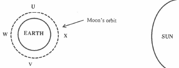 |
At which position of the moon is lunar eclipse likely to occur?
- V
- W
- U and V
- U
- X
(viii) Husna and his young brother Hamid like to play with wet soil around their home. They enjoy observing quick percolation of water in the soil. What type of soil were they playing with?
- Clay
- Silt
- Loam
- Sand
- Silt and clay
(ix) Earthquakes and volcanoes have a clearly identifiable pattern over the earth's surface. Which area is not prone to earth quakes and volcanoes?
- Coast of Alaska
- East African rift valley
- Andes mountain
- Himalayan belt
- Sahara desert
(x) Which location of mineral occurrence is best for shaft method of mining?
- Horizontal to the earth's surface
- Very close to the earth's surface
- In a river valley
- On the earth's surface
- Lay deep into the earth's surface
THE UNITED REPUBLIC OF TANZANIA NATIONAL EXAMINATIONS COUNCIL OF TANZANIA CERTIFICATE OF SECONDARY EDUCATION EXAMINATION
013 GEOGRAPHY
(For Both School and Private Candidates)
Time: 3 HoursYear: 2021
Instructions
- This paper consists of sections A, B and C with a total of ten (10) questions.
- Answer all questions in section A and B and two (2) questions from section C.
- Section A carries fifteen (15) marks, section B fifty five (55) marks and section C carries thirty (30) marks.
- Map extract of Mbeya (Sheet 244/4) is provided.
- Programmable Calculators, Cellular phones and any unauthorised materials are not allowed in the examination room.
- Write your Examination Number on every page of your answer booklet(s).
SECTION A (15 Marks)
Answer all questions in this section.
1. For each of the items (i) - (x), choose the correct answer from among the given alternatives and write its letter in the answer booklet(s) provided.
(i) The solar system is made up of the sun, planets and other heavenly bodies which revolve around the sun. Which planet has the shortest orbit?
- Pluto
- Mercury
- Mars
- Earth
- Venus
(ii) Asha was observing the uniform removal of top thin layer of the soil by running water in the rainy day. What type of soil removal was she observing?
- Splash erosion
- Gully erosion
- Sheet erosion
- Rill erosion
- Wind erosion
(iii) Tanzanian population structure is concave in shape. What is the implication of this shape?
- Birth rate is high, low life expectancy and high death rate
- Low birth rate, high life expectancy and stable growth rate
- Birth rate is high, high infant mortality and high death rate
- Birth rate is low, low infant mortality and high death rate
- Birth rate is high, high life expectancy and stable growth rate
(iv) Form One students were watching a Television program on various human activities in Maisha village. Which among the observed activities is not the cause of environmental destruction in that Village?
- Afforestation
- Charcoal burning
- Lumbering
- Fire wood cutting
- Construction activities
(v) Maneno's village has rainfall throughout the year and is surrounded by dense forest. Which type of forest do you think could be found in his village?
- Mangrove forest
- Coniferous forest
- Tropical forest
- Temperate forest
- Semi-arid forest
(vi) What is the main cause of time variation between Lamu 40°E and Tunis 10°E?
- Rotation of the earth
- Differences in longitudes
- Revolution of the earth
- Rotation and revolution
- Differences in latitudes
(vii) Form Three students were taught that, the Southern Tourist Circuit in Tanzania promotes ecotourism. Which of the following is not encouraged in the promotion of ecotourism in the area?
- Afforestation
- Protecting endangered species
- Coastal attraction
- Environmental conservation
- Discouraging forest fire
(viii) Which one is a factor that affects temperature between Tanzania and Netherlands?
- Altitude
- Solar system
- The sun
- Solar energy
- Heavenly bodies
(ix) It is observed that, there is mineral exhaustion in Kahama district and the production is very minimal. Which one is the best alternative economic activity that can be adopted by the people living in the area so as to improve the standard of their life?
- Improving methods of extraction
- Reducing population
- Reclaiming the affected areas for agriculture
- Developing other sources of energy
- Establishing industries
(x) The owner of a plastic industry ordered the management to use environmental friendly energy sources in production. Which energy source could be used in that industry?
- Petroleum
- Nuclear
- Fuel wood
- Coal
- Solar
THE UNITED REPUBLIC OF TANZANIA NATIONAL EXAMINATIONS COUNCIL OF TANZANIA
CERTIFICATE OF SECONDARY EDUCATION EXAMINATION
013 GEOGRAPHY
(For Both School and Private Candidates)
Time: 3 Hours Year: 2020
Instructions
l . This paper consists of sections A, B and C with a total of ten (10) questions.
2. Answer all questions in section A and B and two (2) questions from section C.
3.Section A carries fifteen (15) marks, section B fifty five (55) marks and section C carries thirty (30) marks.
4.Map extract of Sikonge (Sheet 137/2) is provided.
5.Programmable calculators, cellular phones and any unauthorised materials are not allowed in the examination room.
6.Write your Examination Number on every page of your answer booklet(s).
SECTION A (15 Marks)
Answer all questions in this section.
1. For each of the items (i) (x), choose the correct answer from among the given alternatives and write its letter in the answer booklet(s) provided. (10 marks)
(i)Why does the sun appear larger than other stars that are seen at night?
- Starlight bends as it passes planets
- The sun is closer to the earth than other stars
- The earth's atmosphere filters out light from other stars
- Daylight brightens the sun making it appear larger
- The capacity of our eyes does not view far during the night
(ii)Which layer of the earth forms the ocean floor'?
- Mantle
- Sial
- Sima
- Core
- Crust
(iii) In the field study, students were told that, soil has certain biological, chemical and physical characteristics. What is the general term for these characteristics?
- soil profile
- soil particles
- soil properties
- soil fertility
- soil formation.
(iv)A girl was crossing a river and accidentally dropped her school bag in the river. The girl cried as she observed her bag being pulled by the river water toward the river mouth. What could the bag named in relation to the river action?
- River erosion
- River transportation
- River load
- River meander
- River bed
(v)Which of the following factors is not the cause of desertification in Tanzania?
- Deforestation
- Urban growth
- Shifting cultivation
- Over fishing
- Bush fire
(vi)Suppose you were interested in developing energy from the remains of living things. What will be the best raw material for your project?
- Running water
- Petroleum
- Solar energy
- Coal
- Natural gas
(vii)The Amazon and Congo basins are regions characterised with the same geographical background to human activities, climate, vegetation and relief. What could be the general term for these regions?
- Natural region
- Natural resources
- Natural vegetation
- Natural landscape
- Natural climate
(viii)Suppose you were given several types of minerals and you were asked to select three non-metallic minerals. What would be your selection from the following alternatives?
- Coal, gold and copper
- Natural gas, silver and diamond
- Oil, diamond and coal
- Copper, silver and oil
- Gold, natural gas and diamond
(ix)The tourists enjoyed the temperature of Zanzibar which was at sea level. They also planned to travel from Zanzibar to Manyara which is 1500m above sea level. What will be the temperature experienced by the tourists in Manyara?
- 230C
- 90C
- 190C
- 0.60C
- 170C
(x)Which of the following occurs when the moon's shadow cast over the earth?
- Solar eclipse
- Lunar eclipse
- Aphelion
- Summer solstice
- Equinoxes
THE UNITED REPUBLIC OF TANZANIA NATIONAL EXAMINATIONS COUNCIL OF TANZANIA CERTIFICATE OF SECONDARY EDUCATION EXAMINATION
013 GEOGRAPHY
(For Both School and Private Candidates)
Time: 3 Hours Wednesday, 06th November 2019 p.m
Instructions
- This paper consists of sections A, B and C with a total of ten (10) questions.
- Answer all questions in sections A and B and any two (2) questions from section C.
- Map extract of Mkomazi (Sheet 109/1) is provided.
- Programmable calculators, cellular phones and unauthorised materials are not allowed in the examination room.
- Write your Examination Number on every page of your answer booklet(s).
SECTION A (15 Marks)
Answer all questions in this section.
1. For each of the items (i) � (x), choose the correct answer from among the given alternatives and write its letter besides the item number in the answer booklet provided.
(i) Which of the following layers of the earths interior is made up of sima and sial?
- Biosphere
- Hydrosphere
- Asthenosphere
- Lithosphere
- Barysphere
(ii) Senegal National team scored a goal at 2:00 pm in Senegal (1500 W). At what time at Burundi (300 E) the goal was scored?
- 2:00 am
- 10:00 am
- 4:00 am
- 10:00 pm
- 12:00 am
(iii) Mitomingi was wondering the way large amount of soil and rock materials were sliding downward towards the steep slope. What geological processes were occurring in that area?
- Weathering and erosion
- Deposition and transportation
- Weathering and denudation
- Mass wasting and transportation
- Erosion and transportation
(iv) You are asked to help a Form Two student who failed to identify the types of forests found in the area with low temperatures. What type of forest will you suggest among the following?
- Tropical rain forest
- Coniferous forest
- Equatorial forest
- Deciduous forest
- Mediterranean forest
(v) Taha used to see a group of herdsmen moving seasonally with their cattle between lowlands and highlands in search of water and pasture. What is the general term for such movement?
- Pastoralism
- Transhumance
- Nomadism
- Semi-nomadic
- Zero grazing
(vi) What is the social-economic advantage of reserved forests to societies?
- Tourism
- Lumbering
- Mining
- Forestry
- Agriculture

(vii) After learning different types of soil texture, students were asked to identify the best type of soil which can be mixed with cement for building a house. What type of soil will be picked by the students who understood the lesson?
- Sandy
- Silt
- Alkaline soil
- Loam
- Clay
(viii) Jane was living in Dar es Salaam since 1990 and works as a secretary in Prime Ministerw Office. In January 2019 she was transferred to a new office in Dodoma region. Identify the type of Janes movement.
- migrant
- emigration
- immigrant
- emigrant
- immigration
(ix) Suppose you want to carry out a field study on atmospheric conditions suitable for growth of crops cultivated on a farm within your village. What are the best components of weather to be considered?
- Rainfall and soil
- Moisture and sunshine
- Rainfall and clouds cover
- Temperature and rainfall
- Humidity and rainfall
(x) Mr. Limfuata had a chance to visit South-East Asia for a study tour and he experienced seasonal reverse of wind in the area. Identify the type of climate in the area.
- Tropical maritime
- Tropical monsoon
- Tropical continental
- Equatorial monsoon
- Equatorial
THE UNITED REPUBLIC OF TANZANIA NATIONAL EXAMINATIONS COUNCIL OF TANZANIA CERTIFICATE OF SECONDARY EDUCATION EXAMINATION
013 GEOGRAPHY
(For Both School and Private Candidates)
Time: 3 Hours Tuesday, 06th November 2018 p.m.
Instructions
- This paper consists of sections A, B, C and D with a total of twelve (12) questions.
- Answer all questions in section A, B and C and one (1) question from each part of section D.
- Map extract of Ilonga (Sheet 265/2) is provided.
- Calculators, cellular phones and any unauthorized materials are not allowed in the examination room.
SECTION A (25 Marks)
Answer all questions in this section.
PHYSICAL AND MATHEMATICAL GEOGRAPHY
1. For each of the items (i) (x), choose the correct answer from among the given alternatives and write its letter besides the item number in the answer booklet provided.
(i) Which of the following instrument is used to measure maximum and minimum temperature?
- Barometer
- Thermometer
- Anemometer
- Sixs thermometer
- Hydrometer.
(ii) Which among the following is an extrusive volcanic feature?
- Crater
- Laccolith
- Batholith
- Sills
- Dykes.
(iii) One of the factors for soil formation is
- organic matters
- mineral matters.
- time.
- water.
- air.
(iv) The layer of the atmosphere which is nearer to the earths surface is called
- troposphere
- stratosphere
- hydrosphere
- mesosphere
- thermosphere.
(v) Which among the following is a heavenly body that possesses and transmits its own light?
- Moon
- Sun
- Earth
- Astreroid
- Planet.
(vi) A region which consists of thick forests, tree dwellers and people who engage in cultivation of rubber, cocoa, bananas and oil palms is known as
- Tropical savanna
- Tropical monsoon
- Polar climate
- Mediterranean
- Equatorial.
(vii) An instrument used to determine Magnetic North is called
- Stevenson screen.
- Compass.
- Thermometer.
- Hygrometer
- Barometer.
(viii)Which of the following is not a process for chemical weathering?
- Carbonation
- Saltation
- Hydrolysis
- Hydration
- Oxidation.
(ix) Which among the following features are produced by wave erosion?
- A Geo, wave cut platform and stack
- Blow hole, sea arch and levee
- Sea arch, beach and stump
- Beach, spit and bars.
- Tombolo, meander and cliff.
(x) If the scale of a map is 1:50,000, what will be the actual ground distance of a river with 18cm on a map?
- 9 km
- 2 km
- 4 km
- 8 km
- 1 km.
THE UNITED REPUBLIC OF TANZANIA NATIONAL EXAMINATIONS COUNCIL
CERTIFICATE OF SECONDARY EDUCATION EXAMINATION
013 GEOGRAPHY
(For Both School and Private Candidates)
Time: 3 Hours Monday, 30thOctober 2017 p.m.
Instructions
- This paper consists of sections A, B, C and D with a total of twelve (12) questions.
- Answer all questions in sections A, B and C and one (1) question from each part of section D.
- Map extract of Arusha (Sheet 55/3) is provided.
- Credit will be given for the use of relevant diagrams.
- Calculators, cellular phones and any unauthorized materials are not allowed in the examination room.
- Write your Examination Number on every page of your answer booklet(s)
SECTIONA(25Marks)
Answer all questions in this section
PHYSICAL AND MATHEMATICAL GEOGRAPHY
For each of the items (i) - (x), choose the correct answer from among the given alternatives and write its letter beside the item(s) number in the answer booklet(s) provided.
(i) The luminous body which provides energy to the solar system is
- Sun
- Earth
- Moon
- Planet
- Satellite.
(ii) The earth�s layer which consists of sial and sima is called
- lithosphere
- hydrosphere
- stratosphere
- atmosphere
- thermosphere.
(iii) Which of the following is the process of wearing down the rock surface by wind where the load becomes cutting tools?
- Deflation
- Attrition
- Abrasion
- Corrasion
- Hydration.
(iv) The renewed power of erosion of a river is called.
- river capture
- river erosion
- river rejuvenation
- river meanders
- river basin.
(v)Prediction of the state of atmosphere in a region for 24 to 48 hours is known as
- weather elements
- weather report
- weather instrument
- weather station
- weather forecasting
(vi) The process through which rain water enters the ground is called
- Evaporation
- Infiltration
- Transpiration
- Condensation
- Percolation.
(vii) The process of changing granite to gneiss rock is known as
- sedimentation
- vulcanism
- denudation
- metamophism
- exfoliation.
(viii) Which of the following is another name for Savanna climate in Africa
- Tropical maritime.
- Warm temperature maritime.
- Tropical grassland.
- Warm temperature desert.
- Cool temperate western margin.
(ix)The process of peeling off and falling of rock mass is called
- disintegration
- weathering
- mass wasting
- erosion
- exfoliation.
(x)Which of the following are features of ocean floor?
- Basin, Ocean deep and Cliff.
- Trench, Continental shelf and Stump
- Trench, Ridge and Ocean deep.
- Ocean deep, Continental shelf and Drumlin.
- Basin, Continental shelf and Tombolo.
THE U NITED R EPUBLIC O F TANZANIA NATIONAL EXAMINATIONS COUNCIL
CERTIFICATE O F S ECONDARY E DUCATION E XAMINATION
013 G EOGRAPHY
(For B oth S chool a nd P rivate Candidates)
Time:3 Hours Wednesday, 02nd November 2016 p.m.
Instructions
1. This paper consists of sections A, B, C and D.
2. Answer all questions in sections A, B and C and one (1) question from each part of section D.
3. Map extract of Hanang (Sheet 84/4) is provided.
4. Calculators and Cellular phones are not allowed in the examination room.
5. Write your Examination Number on every page of your answer booklet(s)
SECTION A (25 Marks)
Answer all questions in this section.
PHYSICAL AND MATHEMATICAL GEOGRAPHY
1. For e ach o f the i tems ( i) - ( x), c hoose t he correct answer from among the g iven a lternatives and write its letter in the a nswer booklet provided.
(i) The speed of the earth quake waves i n t he earth is c hanged at a line called
- Mohorovic discontinuity
- Gutenberg discontinuity
- Tectonics
- Tectonics
- Isostatic.
(ii) Liverpool team scored a goal at 5.00 pm in England (15� W). At what time the goal was scored in Dar es Salaam (45� E)?
- 1.00 p.m
- 7.00 p.m
- 9.45 p.m
- 9.00 p.m
- 6.30 a.m.
(iii) The sun is overhead attropic of Capricorn every year on
- 22nd December
- 21st March
- 23rd September
- 21st June
- 24th March.
(iv)Day reaches its maximum length on 21st June in
- Southern hemisphere
- Northern Hemisphere
- Arctic Circle
- Polar region
- Tropic of Capricorn.
(v) Which of the following planets have small celestial bodies in orbit a round them?
- Mercury, Jupiter and Uranus
- Pluto, Earth a nd Mars
- Earth, Jupiter and Saturn
- Mercury, Venus and Earth
- Venus, Earth and Saturn.
(vi) Deposition of soil materials removed from one horizon to another is called
- Convex sided
- Concave sided
- Gentle sided resistance
- Steep sided resistant
- Steep sided non resistance.
(vii) The excessive strong wind blowing across an extensive ocean surface is called
- Tsunami
- Ocean currents
- Storm s urge
- Hurricane
- Wind.
(ix) Rainfall that occurs when the air moves towards a hill or a mountain is called
- cyclonic
- orographic
- convectional
- showers
- typhoon.
(x) Mountains can be classified on the basis o f
- their importance
- their s urrounding
- their c omposition
- their formation
- their height.
(x) A channel diverging from the main river a nd flowing into the sea or a lake by a separate mouth is called
- tributary
- stream
- distributary
- river basin
- water shade.
THE UNITED REPUBLIC OF TANZANIA NATIONAL EXAMINATIONS COUNCIL
CERTIFICATE OF SECONDARY EDUCATION EXAMINATION
013 GEOGRAPHY
(For Both School and Private Candidates)
Time: 3 Hours Thursday, 05thNovember 2015 a.m.
Instructions
1. This paper consists of sections A, B, C and D.
2. Answer all questions in sections A, B and C and one (1) question from each part of section D.
3. Map extract of Kasamwa (sheet 32/4) is provided.
4. Credit will be given for the use of relevant diagrams.
5. Calculators and Cellular phones are not allowed in the examination room.
6. Write your Examination Number on every page of your answer booklet(s)
SECTION A (25 Marks)
Answer all questions in this section.
PHYSICAL AND MATHEMATICAL GEOGRAPHY
1. For each of the items (i) � (x), choose the correct answer from among the given alternatives and write its letter in the answer booklet provided.
(i) Autumn, winter, spring and summer are the result of
- monsoon
- lunar eclipse
- rotation
- revolution
- tides.
(ii) A large part of the Southern Hemisphere is covered by
- land mass
- volcanoes
- water mass
- dark clouds E ice.
(iii) The shallow part of the sea that stretches out from the coast is called
- Continental shelf
- Continental slope
- Ocean ridge
- Ocean trench
- Island.
(iv) Which of the following is not a factor influencing temperature of a place?
- Aspect.
- Ocean current.
- Altitude.
- Eclipse.
- Length of a day.
(v) The sideways erosion which widens the V�-shaped valley is known as
- vertical erosion
- lateral erosion
- headward erosion
- hydraulic action
- attrition.
(vi) Deposition of soil materials removed from one horizon to another is called
- illuviation
- weathering
- eluviation
- organic sorting
- leaching.
(vii) Which of the following results to vertical movements within the earth�s crust?
- Earthquake, faulting and volcanic eruptions.
- Block mountains, raised beaches and broad basins.
- Volcanic eruptions, rock fall and asymmetric folds.
- Fold mountains, basins and asymmetrical folds.
- Emerged coasts, over folds and faulting.
(viii) Which among the following features is the impact of water action in the desert?
- Yardang
- Gullies
- Badlands
- Sinkholes
- Rock pedestals.
(ix) An active state of decomposition caused by soil microorganism is called
- organic matter
- soil water
- mineral matter
- soil air
- soil components.
(x) Which of the following is associated with magnitude of an earthquake?
- Richter scale
- Seismography
- Focus
- Epicenter
- Tsunami.
THE UNITED REPUBLIC OF TANZANIANATIONAL EXAMINATIONS COUNCIL
CERTIFICATE OF SECONDARY EDUCATION EXAMINATION
013 GEOGRAPHY
(For Both School and Private Candidates)
Time: 3 Hours Thursday, 06thNovember 2014 a.m.
Instructions
1. This paper consists of sections A, B, C and D.
2. Answer all questions in sections A, B and C and one (1) question from each part of section D.
3. Map extract of Songwe River (sheet 244/3) is provided.
4. Credit will be given for the use of relevant sketch maps and diagrams.
5. Calculators and cellular phones are not allowed in the examination room.
6. Write your Examination Number on every page of your answer booklet(s)
SECTION A (25 MARKS)
Answer all questions in this section.
PHYSICAL AND MATHEMATICAL GEOGRAPHY
1. For each of the items (i) - (x), choose the correct answer from among the given alternatives and write its letter beside the item number in the answer booklet provided.
(i) Zeugens and yadangs differ in
- position of the rock strata
- position of the rock in the slope
- place of formation
- colour of the rock on which they are formed
- the type of the rock on which they are formed.
(ii) An old age stage of the river is called
- Valley Stage
- Torrent Stage
- Plain Stage
- Mature Stage E Youthful Stage.
(iii) The summer solstice in the northern hemisphere occurs on
- 23rd September
- 21st September
- 22nd December
- 21st March
- 21st June
(iv) A Stevenson�s box is painted by white colour in order to
- improve insulation
- be seen clearly
- decorate it
- allow thermometers to be placed
- allow movement of air.
(v) A stony desert is called
- hamada
- reg
- barchan
- erg
- rock pedestal.
(vi) The temperature at Korogwe 950 metres is 24�C. What is the temperature of Kilimanjaro 5895 metres above sea level?
- 34�C.
- 5.67�C.
- 18.1�C.
- 10.24�C.
- 32�C.
(vii) When two lateral forces act away from each other are known as
- horizontal forces
- orogenic forces
- vertical forces
- compression forces
- tension forces.
(viii) Water vapour is turned into water droplets in the process known as
- evaporation
- convection
- saturation
- condensation
- transpiration.
(ix) Which of the following features produced by ice action is the result of both erosional and depositional activities?
- Ar�te.
- Hanging Valley.
- Erratic.
- Cirque.
- Roche Mountonee.
(x) The name given to earthquake waves that travel within a crust is
- focus
- epicentre
- seismic
- surface waves
- body waves.
THE UNITED REPUBLIC OF TANZANIA
NATIONAL EXAMINATIONS COUNCIL CERTIFICATE OF SECONDARY EDUCATION EXAMINATION
013 GEOGRAPHY
(For School Candidates Only)
Time: 3 Hours Monday, 04thNovember 2013 a.m.
Instructions
1. This paper consists of sections A, B, C and D.
2. Answer all questions in sections A, B and C and one (1) question from each part of section D.
3. Map extract of Kigoma (Series Y742 sheet 92/3) is provided.
4. Credit will be given for the use of relevant sketch maps and diagrams.
5. Calculators and cellular phones are not allowed in the examination room.
6. Write your Examination Number on every page of your answer booklet(s)
SECTION A (25 Marks)
Answer all questions in this section.
PHYSICAL AND MATHEMATICAL GEOGRAPHY
1. For each of the items (i) - (x), choose the correct answer from among the given alternatives and write its letter beside the item number.
(i) A cirque is
- an arm-chair shaped depression on a glaciated lowland area
- an arm-chair shaped depression on the sides of a glaciated mountain
- an arm-chair shaped depression in the desert areas
- an arm-chair shaped valley in glaciated areas
- an arm-chair shaped depression on the plateau.
(ii) A geyser can be described as
- a hot spring
- an explosion of volcanic vapour
- a fountain of superheated water and steam
- a thermal stream
- a pool of hot water.
(iii) Which one of the following conditions is important for the growth of coral reefs?
- Warm and muddy river water
- Warm and muddy sea water
- Warm and clear sea water
- Warm and clear tape water
- Warm and clear river water.
(iv) A time accepted throughout a time zone of 15� longitude is known as
- local time
- noon time
- greenwich mean time
- sun time
- standard time.
(v) Which sequence of the following processes is necessary for the formation of rainfall?
- Condensation, cooling and evaporation
- Evaporation, cooling and condensation
- Evaporation, sedimentation and cooling
- Evaporation, condensation and cooling
- Evaporation, cooling and sedimentation.
(vi) Which of the following instruments is used to measure pressure?
- Wet and dry bulb thermometer
- Aneroid barometer
- Anemometer
- Rain gauge
- Hygrometer.
(vii) Faulting may lead to the formation of
- rift valleys
- moraines
- ox-bow lakes
- boulder clays
- yardangs.
(viii) Which of the following statements is true to an equatorial region?
- It has a small annual range of temperature
- It has four rainfall maxima
- It experiences temperatures below 20�C
- It has a high annual range of temperature
- It is found between 15� and 30� north and south of the equator.
(ix) The earth�s crust is also known as
- atmosphere
- hydrosphere
- mantle
- lithosphere
- troposphere.
(x) What is the compass bearing of WNW?
- 270�
- 337�
- 315�
- 327�
- 292�
THE UNITED REPUBLIC OF TANZANIA NATIONAL EXAMINATIONS COUNCIL
CERTIFICATE OF SECONDARY EDUCATION EXAMINATION
013 GEOGRAPHY
(For School Candidates Only)
Time: 3 Hours Wednesday, 10thOctober 2012a.m.
Instructions
1. This paper consists of sections A, B, C and D.
2. Answer all questions in sections A, B and C and one (1) question from each part of section D.
3. Map extract of Korogwe (Series Y742 sheet 129/2) is provided.
4. Credit will be given for the use of relevant sketch maps and diagrams.
5. Calculators and cellular phones are not allowed in the examination room.
6. Write your Examination Number on every page of your answer booklet(s)
SECTION A (25 Marks)
Answer all questions in this section.
PHYSICAL AND MATHEMATICAL GEOGRAPHY
1. For each of the items (i) - (x), choose the correct answer from among the given alternatives and write its letter beside the item number.
(i) The outer layers of the earth include:
- Atmosphere, Lithosphere and Troposphere
- Atmosphere, Troposphere and Biosphere
- Atmosphere, Hydrosphere and Biosphere
- Atmosphere, Lithosphere and Biosphere
- Atmosphere, Hydrosphere and Lithosphere.
(ii) Which of the following is the effect of mass wasting?
- Frost action
- Interlocking spur
- Rock fall
- Exfoliation
- Rock disintegration.
(iii) The columns of clay capped by boulders formed due to rain action are known as:
- soil creep
- gullies
- land slide
- earth pillars
- cuesta
(iv) Which of the following features is formed by river erosion?
- pot hole
- ox bow lake
- delta
- flood plain
- lagoon.
(v) Rotation of the earth results to:
- elliptical orbit
- change of seasons
- day and night
- leap year
- standard time.
(vi) __________ are good examples of fold mountains in Africa.
- Uluguru and Oldoinyo Lengai
- Jos and Karoo
- Elgon and Kilimanjaro
- Atlas and Cape Ranges
- Udzungwa and Kilimanjaro.
(vii) Which one of the following is a process of wind erosion?
- Abrasion
- Corrosion
- Hydrolysis
- Exfoliation
- Attrition.
(viii) A great circle is a circle on a globe whose plane:
- passes through the centre of the globe
- has the shortest distance between two points
- is perpendicular with the globe
- marks a line of longitude
- marks a line of latitude.
(ix) The intensity of an earthquake is measured by:
- epicentre
- seismograph
- richter scale
- chronometer
- mercalli scale.
(x) Soil texture refers to:
- arrangement of soil particle
- size of individual soil particles
- soil catena
- soil PH
- grained structure.
THE UNITED REPUBLIC OF TANZANIA
NATIONAL EXAMINATIONS COUNCIL CERTIFICATE OF SECONDARY EDUCATION EXAMINATION
013 GEOGRAPHY
(For School Candidates Only)
Time: 3 Hours Tuesday, 4th O ctober 2011 a.m
Instructions
1. This paper consists of sections A, B, C and D.
2. Answer all questions in sections A, B and C and one (1) question from each part of section D.
3. Map extract of Malampaka (sheet 49/1) is provided.
4. Credit will be given for the use of relevant sketch maps and diagrams.
5. Calculators and cellular phones are not allowed in the examination room.
6. Write your Examination Number on every page of your answer booklet(s)
SECTION A (25 Marks)
Answer all questions in this section.
PHYSICAL AND MATHEMATICAL GEOGRAPHY
1. For each of the items (i) - (x), choose the correct answer from among the given alternatives and write its letter beside the item number.
(i) One of the following features is a characteristic of coniferous forests:
- Trees are made up of hard wood
- Trees occur in stands
- Trees favour high temperatures
- Trees have broad leaves
- Trees grow in a few years.
(ii) The Inter-Tropical Convergence Zone (ITCZ) means
- a region of low pressure
- a region of doldrums
- a region of high pressure
- a sub-tropical high pressure belt
- a region with high speed winds.
(iii) Rias often provide natural harbour because they are
- found along the sub-merged coast.
- mainly found in Europe where the sea is shallow
- deep outlets of water along the coast
- not deep, ships can approach ports easily
- similar to lagoons but have shallow depths.
(iv) If the local time at town X (30�E 45�N) is 5.00 p.m. Monday, what will the time be at town Y (15�W 50�S)?
- 2 a.m. Monday
- 8 p.m. Monday
- 2 p.m. Monday
- 3 p.m. Monday
- 2 p.m. Sunday.
(v) The following are instruments used in chain and tape survey:
- Barometer, pegs, notebook, compass
- Tape measure, chain, cross staff, anemometer
- Chain, arrows, ranging poles, altimeter
- Arrows, ranging poles, pegs, chain
- Cross staff, notebook, chain and plane table.
(vi) When the river flows in its long profile it performs the following geological activities:
- Moves fast and can carry everything on the earth�s surface
- Erodes, transports and deposits weathered materials
- Meanders and forms ox-bow lakes throughout the profile
- Does three functions such as abrasion, solution and attrition
- Acts as agent of weathering and erosion along the profile.
(vii) If the location of a point on a map is given by grid reference 365490, then
- 365 are Degrees
- 365 are Longitudes
- 490 are Northings
- 490 are Eastings
- 365 are Northings
(viii) The following are the elements of weather:
- Soils, clouds, dew, humidity, rainfall
- Fog, barometer, humidity, pressure, air mass
- Clouds, sunshine, pressure, humidity, thermometer
- Pressure, clouds, sunshine, humidity, winds
- Pressure, humidity, soils, fog.
(ix) Which one of the following is not an outcome of the rotation of the earth on its own axis?
- Deflection of winds and ocean currents
- Difference of one hour between two meridians 15� apart
- Day and night
- Seasons of the year
- Sunrise and sunset.
(x) Landforms formed by vulcanicity can be divided into
- Many parts according to the nature of lava
- Sills, dykes, valleys and earthquakes only
- Volcanic mountains and sills only
- Extrusive and intrusive features
- Batholiths, dykes and volcano only.
THE UNITED REPUBLIC OF TANZANIA NATIONAL EXAMINATIONS COUNCIL
CERTIFICATE OF SECONDARY EDUCATION EXAMINATION
013 GEOGRAPHY
(For School Candidates Only)
Time: 3 Hours Tuesday, 5th O ctober 2010 a.m.
Instructions
1. This paper consists of sections A, B, C and D.
2. Answer all questions in sections A, B and C and one (1) question from each part of section D.
3. Map extract of LINDI is provided.
4. Credit will be given for the use of relevant sketch maps and diagrams.
5. Calculators and cellular phones are not allowed in the examination room.
6. Write your Examination Number on every page of your answer booklet(s)
SECTION A (25 Marks)
Answer all questions in this section.
PHYSICAL AND MATHEMATICAL GEOGRAPHY
1. For each of the items (i) � (x), choose the correct answer from among the given alternatives and write its letter beside the item number.
(i) Crater lakes are most likely to be formed in
- areas of fold mountains
- intensively faulted areas
- downwarped areas
- regions where subsidence is taking place
- areas of active vulcanicity.
(ii) Which one of the following is not associated with earthquakes?
- Body waves
- Geyser
- Richter scale
- Seismograph
- Focus.
(iii) If the time at town X 15�E is 12.00 noon, what could be the longitude of town Y if it is 8.00 a.m?
- 15�W
- 30�E
- 45�W
- 30�W
- 45�E
(iv) Which one of the following, by origin and composition is not a form of igneous rocks?
- Sill
- Gypsum
- Lava plain
- Volcano
- Granite.
(v) One of the following features is a product of weathering:
- Earth pillar
- Gully
- Lilly
- Hot springs
- Soil creep.
(vii) A scale of 4 cm representing 18 km on the ground will be represented by representative fraction (R.F) scale as
- 1 : 900000
- 1 : 1800000
- 1 : 450000
- 2 : 900000
- 1 ? 10,000
(viii) Which one of the following owes its origin to deflation?
- Qattara depression
- Lake turkana
- Tekekitarn
- Lake Chad
- Lake Victoria.
(ix) The presence of paired terraces on both sides of a river valley indicates that
- river capture has taken place
- lateral erosion is dominant
- sea level has risen
- rejuvenation has taken place
- truncated spurs have retreated.
(x) A good example of intrusive igneous rocks is
- gneiss
- basalt
- gabbro
- marble
- imestone.
THE UNITED REPUBLIC OF TANZANIA NATIONAL EXAMINATIONS COUNCIL
CERTIFICATE OF SECONDARY EDUCATION EXAMINATION
013 GEOGRAPHY
(For School Candidates Only)
Time:3 Hours Tuesday, 8th October 2009 p.m.
Instructions
1. This paper consists of sections A, B, C and D.
2. Answer all questions in sections A, B and C and one (1) question from each part of section D.
3. Map extract of Galula is provided.
4. Credit will be given for the use of relevant sketch maps and diagrams.
5. Electronic calculators and cellular phones are not allowed in the examination room.
6. Write your Examination Number on every page of your answer booklet(s)
SECTION A (25 Marks)
Answer all questions in this section.
PHYSICAL AND MATHEMATICAL GEOGRAPHY
1. For each of the items (i) - (x), choose the correct answer from among the given alternatives and write its letter beside the item number.
(i) The solar system is made up of
- sun, planets and interplanetary gases
- atmosphere and hydrosphere
- planets, clouds and gases
- clouds, wind and gases
- sunlight, gases, wind and clouds.
(ii) If the time recorded at time X, 45°E was 9.00 a.m. what could be the longitude of Y at 3.00 a.m.
- 90°W
- 45°W
- 15°E
- 90°E
- 75°W
(iii) Lunar eclipse occurs because
- the moon comes between the earth and the sun
- the earth comes between the moon and the sun
- the earth rotates from west to east
- the sun comes between the moon and the earth
- the moon, the earth and the sun are in rotation.
(iv) About 98% of the matter making the sun is
- light and heat
- heavier elements
- tars and other heavenly bodies
- lighter elements of hydrogen and helium
- gases, heat and sun ray.
(v) Absence of drainage on the surface in the limestone region is the direct result of
- very low rains in the area
- presence of swallow holes
- the big rivers which swallow small rivers
- presence of deep gorges
- presence of sound and big pores.
(vi) The following are marine depositional features:
- Beach, lagoons and sand spits
- Beach, fringing reef and stump
- Beach, stump and atoll
- Tombolo, delta and headland
- Headland, geo and stacks.
(vii) Why do two different countries located in different latitudes or hemispheres experience similar type of natural vegetation? It is because of
- their positions which are very far
- similar traditions of the people living in those areas
- the same type of climate
- same onshore prevailing winds
- fertile soils, good could cover and rains.
(viii) ………. shows the soil’s grain size.
- Soil texture
- Soil structure
- Soil morphology
- Particle density
- Soil profile
(ix) Temperate cyclones are characterized as follows:
- They are instruments with cycles for measuring temperature
- Have long hours of high temperature
- They are temperate winds which have a high speed
- They are low pressure centres which develop in temperate Latitudes
- They are strong temperate rains in the United States of America, Africa and the Congo basin.
(x) A vertical cross-section of the soil showing its horizons is called
- soil erosion
- soil porosity
- soil profile
- soil PH
- soil catena.
THE UNITED REPUBLIC OF TANZANIA NATIONAL EXAMINATIONS COUNCIL
CERTIFICATE OF SECONDARY EDUCATION EXAMINATION
013 GEOGRAPHY
(For Both School and Private Candidates)
TIME: 3 Hours Thursday afternoon 11/10/2007
Instructions
1. This paper consists of sections A, B, C and D.
2. Answer all questions in sections A, B and C and one (1) question from each part of section D.
3. Map extract of Kigoma sheet 92/3 is provided.
4. Credit will be given for the use of relevant sketch maps and diagrams.
5. Cellular phones are not allowed in the examination room.
6. Electronic calculators are not allowed in the examination room.
7. Write your Examination Number on every page of your answer booklet(s)
SECTION A (25 Marks)
Answer all questions in this section.
PHYSICAL AND MATHEMATICAL GEOGRAPHY
1. For each of the items (i) - (x), choose the correct answer from among the given alternatives and write its letter beside the item number.
(i) Clay as a parent rock can be classified as __________ rock.
- pervious
- porous
- permiable
- impermiable
- permiable and impermiable
(ii) Circular depressions which are formed by glaciations in the highlands are
- caldera
- craters
- cirques
- hanging valleys
- aretes.
(iii) A drainage pattern, which looks like a tree with its branches is called
- trellised
- dendritic
- radial
- centripetal
- annular.
(iv) The second layer of the earth’s crust is known as
- sial
- sima
- mantle
- core
- gotenburg gap.
(v) Wadis, Bajada, Buttes and Mesa are examples of __________ features.
- wind erosion and deposition
- glacial erosion and deposition
- wave erosion and deposition
- desert water erosion and deposition
- river erosion and deposition
(vi) Which one of the following combinations form chemical weathering?
- Organic acid and weak carbonic acid.
- Temperature change and frost action.
- Exfoliation and carbonation.
- Mud flow and land slides.
- Organic acid and temperature change.
(vii) A vertical feature formed out of the solidification of magma within the earth’s crust is called
- phacolith
- sill
- dyke
- lopolith
- lacolith.
(viii) A coral reef with a circular elliptical shape enclosing a lagoon is called
- fringing reef
- barrier reef
- lagoon
- atoll
- planktons.
(ix) If the temperature at 500 metres where the tourists start climbing mount Kilimanjaro is 20°C. What will be the temperature when they reach 2,000 metres above sea level?
- 10°C.
- 5°C.
- 11°C
- 12°C
- 15°C.
(x) The process in which a river renews its erosion in its valley is called
- regime
- rejuvenation
- capture
- cavitation
- abrasion.
THE UNITED REPUBLIC OF TANZANIA NATIONAL EXAMINATIONS COUNCIL
CERTIFICATE OF SECONDARY EDUCATION EXAMINATION
GEOGRAPHY
(For Both School and Private Candidates)
TIME: 3 Hours October , 2006
Instructions
1. This paper consists of sections A, B, C and D.
2. Answer all questions in sections A, B and C and one (1) question from each part of section D.
3. Map extract of Tabora sheet 118/2 is provided.
4. Credit will be given for the use of relevant sketch maps and diagrams.
5. Electronic calculators are not allowed in the examination room.
6. Cellular phones are not allowed in the examination room.
7. Write your Examination Number on every page of your answer booklet(s)
SECTION A (25 marks)
PHYSICAL AND MATHEMATICAL GEOGRAPHY
1. For each of the items (i) - (x) choose the correct answer from among the given alternatives and write its letter beside the item number.
(i)The rotation of the earth causes the following except:
- day and night
- seasons
- difference of one (1) hour between two meridians of 150
- the deflation of winds and ocean currents
- the daily rising and falling of the ocean tides
(ii)Which of the following develops at the bottom of a waterfall?
- Plunge pool
- delta
- different junction
- playa river regime
(iii)The crust is sometimes referred to as:
- lithosphere
- hydrosphere
- troposphere
- mesosphere
- tropopause
(iv)The force of water that wears out soft rocks such as clay is known as:
- hydraulic action
- solution action
- attrition action
- corrasion action
- siltation action
(v)The name given to a boundary that demarcates solid materials from the molten mantle is:
- asthenosphere
- Gutenberg
- mohorovic
- mesosphere
- core
(vi)What is the longitude of Morogoro if its local time is 10:00 p.m., whereas the longitude of Accra in Ghana is 00 and local time is 7:00 p.m.?
- 450E
- 450W
- 350E
- 350W
- 600W
(vii) . . . . . . . . . . is a point where cold air from the polar regions meets warmer air from lower latitudes.
- polar front
- tropical maritime
- cyclone
- humidity
- pressure gradient
(viii)Which of the following types of lakes does not occur from depositional factor?
- Playa
- Tarn
- Ox-bow
- Delta
- Lagoon
(ix)Salinity of ocean water increases with:
- increased rate of evaporation of ocean water
- distance from the equatorial region
- depth of the sea water
- altitude
- increasing rainfall
(x)Soil structure refers to the:
- size of soil particles
- arrangement of soil particles
- soil ninerals and contents
- soil pH
- soil catena
THE UNITED REPUBLIC OF TANZANIA NATIONAL EXAMINATIONS COUNCIL
CERTIFICATE OF SECONDARY EDUCATION EXAMINATION
013 GEOGRAPHY
(For Both School and Private Candidates)
TIME: 3 Hours Thursday, October 13, 2005 p.m.
Instructions
1. This paper consists of sections A, B, C and D.
2. Answer all questions in sections A, B and C and one (1) question from each part of section D.
3. Map extract of Tabora sheet 118/2 is provided.
4. Credit will be given for the use of relevant sketch maps and diagrams.
5. Electronic calculators are not allowed in the examination room.
6. Cellular phones are not allowed in the examination room.
7. Write your Examination Number on every page of your answer booklet(s)
SECTION A (25 marks)
PHYSICAL AND MATHEMATICAL GEOGRAPHY
1. For each of the items (i) - (x), choose the correct answer from among the given alternatives and write its letter beside the item number.
(i) The earth’s shape is a flattened sphere which is called
- ekman spiral
- geoid
- globe
- galtax
- spherical.
(ii) ________ occurs when three heavenly bodies are in one line and one of them being the source of light.
- Solar system
- Equinox
- Eclipse
- Solstice
- Solar radiation.
(iii) The Secretary General of the UN addressed the world from New York (75°W 42°N) at 7:30 p.m. Tuesday. At what time and day will people in Dar Es Salaam (45°E 06°S) hear the same speech?
- 3:30 a.m. Wednesday
- 12:30 p.m. Tuesday
- 11:30 p.m. Wednesday
- 3:30 p.m. Wednesday
- 8:30 p.m. Tuesday.
(iv) The temperature at Moshi 950 metres is 24°C. What will the temperature be at Uhuru Peak 5,895 metres above sea level?
- 32°C
- ?8°C
- ?24°C
- 18°C
- 0°C
(v) When two forces act away from each laterally, they are called
- lateral forces
- orogenic forces
- vertical forces
- compressional forces
- tensional forces.
(vi) A delta which is found in a lake is called ________ delta.
- marine
- lacustrine
- alluvial
- arcute
- bird’s foot
(vii) A natural outflow of water from the surface rock is known as
- oasis
- stream
- artesian well
- spring
- aquifer.
(viii) When several rivers drain into a depression they form a drainage system called ________ drainage.
- radial
- superimposed
- trellised
- centripetal
- dendritic
(ix) A soluble rock with jointed structure resembling a wall is called
- granite
- grike
- basalt
- limestone
- clint.
(x) The Barysphere of the earth is made up of
- silica and magnesia
- silica and alumina
- iron and nickel
- iron and zinc
- iron and alumina.
THE UNITED REPUBLIC OF TANZANIA NATIONAL EXAMINATIONS COUNCIL OF TANZANIA CERTIFICATE OF SECONDARY EDUCATION EXAMINATION
GEOGRAPHY
(For Both School and Private Candidates)
Time: 3 Hours Year: 2004
SECTION A
PHYSICAL AND MATHEMATICAL GEOGRAPHY
1. For each of the items (i) — (x) choose the correct answer from among t he given alternatives and write its letter beside the item number.
(i) River erosion operates in three ways, namely:
- surface, vertical and lateral
- headward, vertical and surface
- lateral, frontal and surface
- frontal lateral and headward
- lateral, subsurface and surface.
(ii) The magnitude of an earthquake refers to:
- effects produced by the earthquake
- large amplitude waves known as L-waves
- point at which earthquake originates
- total amount of energy released
- point on the earth surface above the focus
(iii)If Ronaldo scores a goal for his team playing in Colombo (800E) at 4:00pm local time. What will be the time at Mtwara in Tanzania (400E)?
- 6:40 a.m.
- 1:20 a.m.
- 6.40 p.m.
- 1:20 p.m.
- 2:40 p.m.
(iv)Plants with long roots, thorny stems, needle shaped leaves, wax or hair are found in:
- the Mediterranean region
- hot deserts
- tropical grasslands
- the equatorial region
- the monsoon region
(v)The part of the earth that forms continental blocks is called:
- Sima
- Core
- Mantle
- Sial
- hydrosphere
(vi)The temperature of Dar es Salaam at sea level is 31 0C. Whatwill be the temperature of Arusha 2500 metres above sea level?
- 160C
- 290 C
- 150C
- 460 C
- 32.5 0C
(vii) Reverse fault is mainly caused by:
- earth movement
- tension force
- an earthquake
- weathering
- compressional force
(viii)Which one among the following features occurs in a glaciated lowland region?
- Esker
- Cirque
- Pyramidal peak
- Hanging valley
- Arete
(ix)The slow movement of soil particles which can be recogniæed by bending of trees and fences is referred to as:
- land slide
- mud flow
- soil creep
- rock fall
- soil erosion
(x)A drainage system of a river where the river flows in accordance with the rock structure is called:
- discordant drainage system
- antecedent drainage system
- superimposed drainage system
- back tilted drainage system
- Accordant drainage system
THE UNITED REPUBLIC OF TANZANIA NATIONAL EXAMINATIONS COUNCIL OF TANZANIA CERTIFICATE OF SECONDARY EDUCATION EXAMINATION
GEOGRAPHY
(For Both School and Private Candidates)
Time: 3 Hours Year: 2003
SECTION A
PHYSICAL AND MATHEMATICAL GEOGRAPHY
1. For each of the items (i) - (x) choose the correct answer from among the given alternatives and write its letter beside the item number.
(i)Which of the following is the evidence which proves that the earth is spherical?
A.The lunar eclipse
B.The four seasons
C.The revolution of the earth
D.The eclipse of the sun E. Equator
(ii)A great circle refers to:
A.a line of longitude
B.a circle of the globe
C.the shortest distance between the two points
D.a circle in the surface whose plane passes through the centre of the globe
E.Greenwich meridian only.
(iii)A reverse fault is caused by:
A.tensional forces
B.down warping of the earth's surface
C. folding
D. compressional forces
E. denudation.
(iv)Tides are highest:
A.during the eclipse
B.during the aphelion
C.during the equinox
D.during the day and night throughout the year
E.at the poles
(v)Micheweni at sea level has a temperature of 320C. What is the temperature of Karatu 1500m above sea level?
A.19 0C
B. 9 0C
C. 0.60 C
D. 17 0C
E. 23 0 C
(vi)Quartz is a compound element of:
A.aluminium and granite
B.feldspar and carbon dioxide
C. manganese and iron
D.iron, granite carbon dioxide
E.silicon and oxygen
(vii)The intensity of an earthquake is measured by an instrument called:
A. epicentre
B.chronometer
C. seismography
D. Richter scale
E. hygrometer
(viii)Which of the following is a limestone surface feature?
A.Stalagmite
B.Underground stream
C.Tombolo
D. Polje
E. Loess
(ix)A stony desert is called:
A.hamada
B. reg
C.barchan
D.erg
E.temperate desert
(x)The following is not a feature formed in the glaciated highland areas:
A.Truncated spar
B.V-shaped valley
C. Crag and tail
D.pyramidal peak
E. Arete
VIEW MARKING SCHEME

 For Call,Sms&WhatsApp: 255769929722 / 255754805256
For Call,Sms&WhatsApp: 255769929722 / 255754805256  Matokeo Darasa VII 2025
Matokeo KIDATO CHA II 2024
Matokeo Darasa IV 2024
SECONDARY REGIONAL EXAMS
PRIMARY REGIONAL EXAMS
FORM VI NECTA REVIEWS
FORM IV NECTA REVIEWS
FORM II NECTA REVIEWS
STD VII NECTA REVIEWS
STD IV NECTA REVIEWS
SECONDARY EXAMS SERIES
PRIMARY EXAMS SERIES
PRIMARY SUBJECT NOTES
SECONDARY SUBJECT NOTES
SECONDARY TOPICAL EXAMS
SECONDARY TOPICAL QUESTIONS
PRIMARY TOPICAL QUESTIONS
PRACTICAL EXAMS & NOTES
SECONDARY REGIONAL EXAMS
DOWNLOAD SUBJECT NOTES
SCHEMES OF WORK (PRIMARY & SECONDARY)
LESSON PLAN
SECONDARY LOG BOOKS
PRIMARY LOG BOOKS
LITERARY WORKS / UCHAMBUZI VITABU
METHALI ZOTE ZA KISWAHILI
Vitendawili Vya Kiswahili
FORM VI RESULTS 2024
FORM FIVE SELECTION 2024
MATOKEO KIDATO CHA IV 2023
FORM ONE SELECTION 2024
FORM VI RESULTS 2023
Matokeo Darasa IV 2022
Matokeo Darasa VII 2025
Matokeo KIDATO CHA II 2024
Matokeo Darasa IV 2024
SECONDARY REGIONAL EXAMS
PRIMARY REGIONAL EXAMS
FORM VI NECTA REVIEWS
FORM IV NECTA REVIEWS
FORM II NECTA REVIEWS
STD VII NECTA REVIEWS
STD IV NECTA REVIEWS
SECONDARY EXAMS SERIES
PRIMARY EXAMS SERIES
PRIMARY SUBJECT NOTES
SECONDARY SUBJECT NOTES
SECONDARY TOPICAL EXAMS
SECONDARY TOPICAL QUESTIONS
PRIMARY TOPICAL QUESTIONS
PRACTICAL EXAMS & NOTES
SECONDARY REGIONAL EXAMS
DOWNLOAD SUBJECT NOTES
SCHEMES OF WORK (PRIMARY & SECONDARY)
LESSON PLAN
SECONDARY LOG BOOKS
PRIMARY LOG BOOKS
LITERARY WORKS / UCHAMBUZI VITABU
METHALI ZOTE ZA KISWAHILI
Vitendawili Vya Kiswahili
FORM VI RESULTS 2024
FORM FIVE SELECTION 2024
MATOKEO KIDATO CHA IV 2023
FORM ONE SELECTION 2024
FORM VI RESULTS 2023
Matokeo Darasa IV 2022


