Chapter 01 : Theories of landforms formation
| Introduction The Earth has diverse range of landforms, from expansive mountain ranges to rolling hills, from deep oceanic trenches to meandering rivers. The formation of these landforms and the processes that create and shape them are of great significance in the field of physical geography. In this chapter you will learn about theories of landforms formation such as continental drift, seafloor spreading, plate tectonics, and isostasy and how they aid in explaining existing landforms. The competencies developed will enable you to demonstrate an advanced understanding of the concept and theories explaining the structure of the Earth and interaction of the earth’s system. It will also enable you to appreciate theoretical linkage between the earth’s processes and formation of landforms. |
| Think about The existence of continents and other landforms on the Earth. |
Theories guiding formation of landforms of the Earth
Activity 1.1
Search from online sources or library about theories explaining the formation of landforms. Write a summary on the key observations and evidence that support each theory you have studied.
The Earth has various landforms such as hills, mountains, plateaus, plains, and valleys which are created and shaped by one or a combination of processes. Understanding how different landforms come into existence is complex. However, theories such as continental drift, plate tectonics, and isostasy provide crucial insights into landform formation.
Continental drift theory
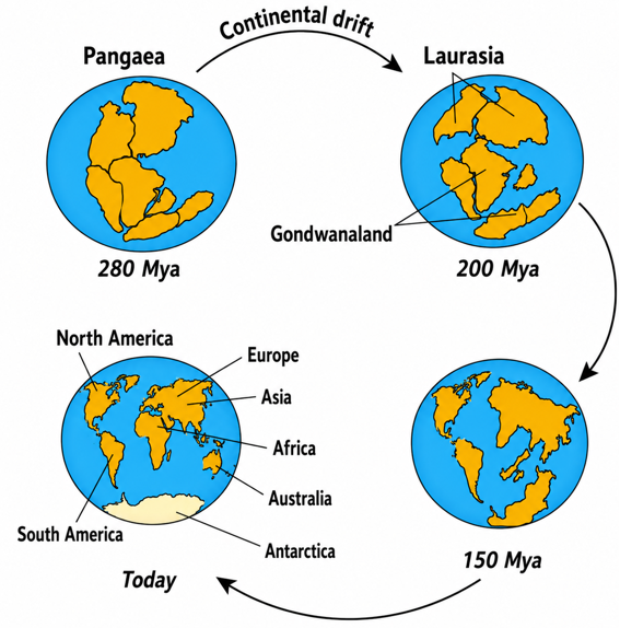
Continental drift theory was initially developed in 1908 by Frank Bursley Taylor who postulated about the concept of horizontal displacement of the continents to explain the distribution of the fold mountains. In 1912 the theory was proposed by Alfred Wegener who explained about how the continents have moved from their original position of the earth’s surface. Wegener explained that the earth’s continents were once united forming a single super-continent land mass called Pangaea (a Greek word meaning all lands together) which was surrounded by a huge water-mass (ocean) called Panthalassa about 280 million years ago. Later on about 200 million years Pangaea broke up to form two land masses, the northern continent which was known as Laurasia and the southern continent called Gondwanaland. These continents were separated by a long narrow sea called Tethys. About 150 million years later, between the Mid-Permian and the Cretaceous periods, Laurasia broke up into three continents, that is Europe, North America and Asia while Gondwanaland broke up and formed Africa, South America, Australia, New Zealand, Antarctica, and India. Subsequent as shown in Figure 1.1.
|
Figure 1.1: Continental drift |
Wegener and other scientists such as Arthur Holmes and Frank Bursley Taylor proposed three main causes of continental drifting which are centrifugal force, tidal attraction and convection transfer of heat.
Centrifugal force
The rotation of the Earth created a centrifugal force towards the Equator. Wegener believed that Pangaea originated near the South Pole and that the centrifugal force to the planet caused the proto continent to break up and resulted into continents drifting towards the equator. He called this action the pole-fleeing force. According to him after breaking away from the Pangaea, the continents moved in two directions namely equatorward and west-ward movements. The equatorward movement of sialic blocks was caused by gravitational force and force of buoyancy. Wegener explained that the lightweight sialic materials were floating without friction on relatively denser (SIMA) materials. Equator-ward movement depended on the relation between the centre of gravity and centre of buoyancy of the floating continental mass.
Tidal attraction
Wegener presumed that tidal influence of the Sun and moon gave the continent westward motion, a counter movement of the revolution of the Earth. Wegener complemented Taylor’s proposal that the main driving force possible for displacement of the continent was tidal force. According to Wegener the attraction force resulted from the Sun and the moon which attained its maximum level when the moon was nearest to the Earth, thus dragged the outer sialic crust (continental blocks) over the interior of the earth towards the West.
Convection and heat transfer
In 1929, Arthur Holmes elaborated one of Wegener’s hypotheses about the idea that the mantle undergoes thermal convection. This idea is based on the fact that, when a substance is heated its density decreases causing it to rise to the surface and when it cools down it sinks again. The repeated heating and cooling results in a current which may be sufficiently strong to cause that substance to slightly move. This is associated with the movement of continents.
Evidence of continental drift
Ever since Wegener and other scholars put forward the continental drift theory, various evidence have been provided to support the idea of continental drift. The following are some of the available evidence to support the theory.
Jig-saw-fit
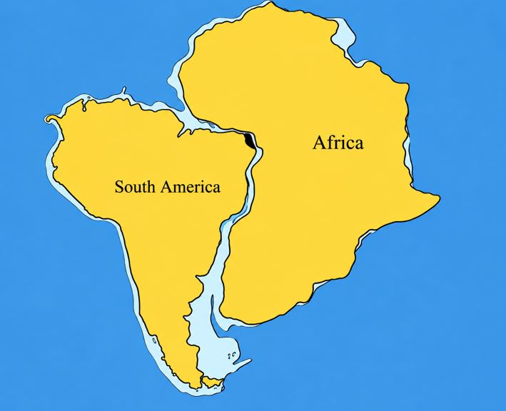
According to Wegener there is a geographical similarity among various coasts of different continents. It was observed that some coastlines of different continents could fit into one another along the margin if brought together. For example, the east coast of South America could fit into the west coast of Africa (Figure 1.2). This is known as Jig-saw fit. The Jig-saw fit implies that all continents were formed from a single landmass.
|
Figure 1.2: Jig-saw fit of the continents |
Activity 1.2
Use internet sources for searching models or simulations that demonstrate the concept of continental drift. Based on the simulation observed, write short notes on the arguments of continental drift theory and its evidence.
Paleontological evidence
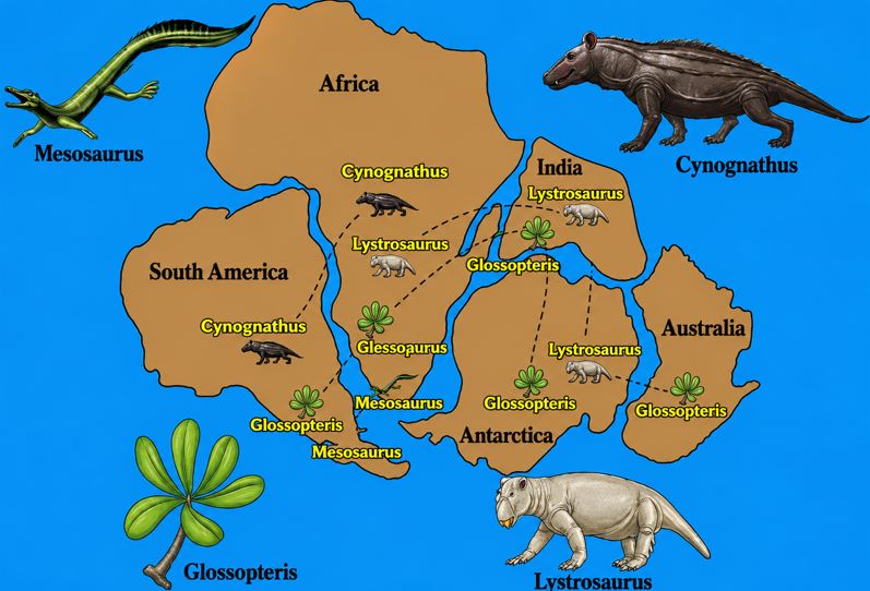
This is a biological evidence which explain the similarity of plants and animals’ fossils in rocks with similar age which are found on the shores of the different continents and which suggests that the continents were once connected. For example, fossils of Mesosaurus, a freshwater reptile, have been found in Brazil and Western Africa and fossils of the land reptile Lystrosaurus have been found in rocks of the same age in Africa, India and Antarctica (Figure 1.3). Moreover, the distribution of Glossopteris flora in India, South Africa, Australia, Antarctica and Falkland island proves the fact that all landmasses were previously united.
|
Figure 1.3: Paleontological evidence of the continental drift |
Geological similarities
These refers to the similarities in the large scale geological features found in different continents. This evidence uses identical rocks in terms of types, structures and ages which are found on both sides of Atlantic Ocean. For example, rocks on the coastlines of South America and West Africa seem to match up. The familiar rock strata of the Karoo system of South Africa matches correctly with the Santa Catarina system in Brazil. Moreover, the mountain ranges with the same rock types, structure and age are now found on the opposite sides of the Atlantic Ocean. For example, the Appalachian Mountains in Eastern North America are linked with the Eastern Greenland mountain ranges.
Evidence from glaciations
During the later part of the Paleozoic era (about 300 million years ago), glaciations occurred throughout the large part of the continent in the Southern hemispheres. The deposits left by these ancient glaciers are recognized by striations and grooves on the underlying rocks showing the direction in which the ice moved. The presence of glacial deposited in the Congo basin where the climate is warm, is used as the evidence that the continents drifted from regions which were cold to currently warm regions. For instance, Africa shifted northwards from the South.
Paleomagnetism
Paleomagnetism also supports the theory that continents changed position over time. When the rocks cooled, they were magnetized in the same direction the magnetic field (magnetic north) is found. The paleo magnetic dating shows that rocks older than 200000 years from different parts of the Earth have shifted their relative position, which indicates the shifting of continents. The shifting of continents is detected by using a sensitive instrument called magnetometer which is capable of determining the direction of magnetic poles at a given geographical period.
The formation of rift valley
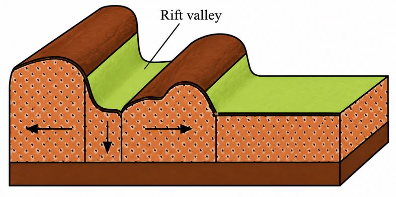
The presence of rift valleys like the Great East African rift valley is another major indication of continental drift. This rift valley was formed due to the movement of plates beneath the continents. The tensional force of the moving plates forms cracks which finally formed a rift valley (Figure 1.4).
|
Figure 1.4: Formation of a rift valley |
The red sea evidence
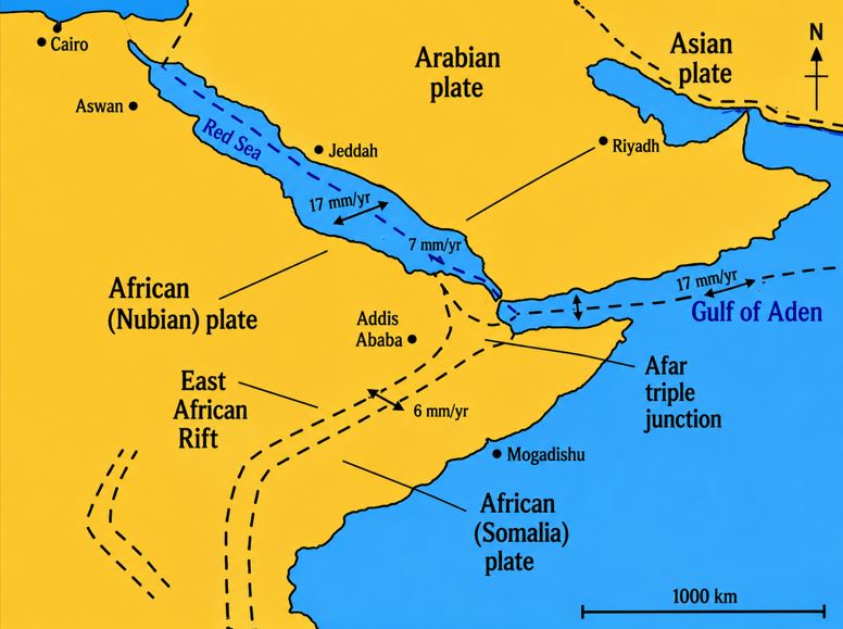
This began as a rift valley 20 million years ago and it is now over 300 km wide. It was formed by the divergence between African continent (plate) and Arabian plate (Figure 1.5).
|
Figure 1.5: Red sea evidence |
Coral reefs in the north pole
Recent expedition to the cold north water especially Arctic have revealed giant deep sea coral reefs. Normally, coral reefs develop in the warm water regions. The presence of coral reefs in the cold north water (Arctic) is an evidence that Laurasia was once located along the tropics.
Geomorphological evidence
This was based on the nature, age, structure and chain of Atlas mountain range in Africa and Alps mountain range in Europe that seem to be similar in age, structure and alignment. It is believed that possibly the mountains were formed when the African plate moved northward due to tectonic movement which resulted into collision with European plate and created the mountain ranges we see today.
The consequences of continental drift
The consequences of continental drift are highlighted based on the formation of physical features, climate change, changes in patterns of ocean currents, evolution of animals and speciation and crustal deformation.
Formation of physical features
Drifting of continents led to the formation of various features such as mountains, oceans, seas and the rift valleys. Taylor (1910) hypothesises that fold mountains were formed as a result of movement of landmass. He further argues that the wrinkling of crust is due to the drifting of continents. The drifting of continents is believed to be causing the natural catastrophes such as earthquakes, volcanic eruption and tsunamis. Drifting up of the landmass resulted in the formation of oceans and seas. For example, westward movement of landmass opened the Atlantic Ocean while Red Sea was formed after a divergence between the African plate and the Arabian plate.
Climate change
Climate change is a long-term shift in weather conditions identified by changes in temperature, precipitation, winds, and other indicators. Climate change can involve both changes in average conditions and changes in variability including, extreme weather events. It is commonly known as net pole-ward movement resulting to same continents shifting to the polar areas where they are assumed that there was very low temperature contrary to those positioned at the Equator where the temperature is high like the African continent.
Change in patterns of ocean currents
The ocean currents in some parts of the world were also affected in terms of temperature. For example, the waters around New Zealand’s South Island cooled from 20°C at the beginning of Eocene period about 56–53 million years ago to 17°C during 30–14 million years ago and then cooling to the present temperature of 12°C.
Evolution of animals and speciation
The rearrangement and displacement of landmasses helped to create the diversity of animals which we see today. Without the continental drift, the Earth today would have been very different in terms of the diversity of animals available in different parts of the world. Continental drift promoted allopatric speciation as when the united landmass separated, regions that were once connected became geographically isolated. Each separate region became an evolutionary arena with plants and animals diverging from those in other continents. For example, the distribution of the flightless running birds or ratites in South America, Africa and Australia is a result of the break up of the Pangaea.
Crustal deformation
The drifting of continents is believed to be causing the natural catastrophes such as earthquakes, volcanic eruption and tsunamis. When the landmasses move they cause crustal deformation when the applied force exceeds the internal strength of the contracted rock. The force creates physical changes and causes fold, fracture and faults. When energy is released brittle deformation causes an earthquake.
Change of economic activities
The change in geographical position caused some changes in human activities in accordance to the nature of the position of that region. For example, if Africa had remained in the Southern pole, some human activities like agriculture would not be possible. Moreover, continental drift resulted into features like sea, ocean, rift valley and mountains. These features have caused various human activities such as fishing and tourism to emerge.
Critiques of the theory of continental drift
Despite the causes and evidence explained, continental drift still faces a number of critiques. Here are some of the main critiques:
It is claimed that, Wegener has failed to explain convincingly the causes and mechanisms of continental drift theory. For instance, Wegener presumed that tidal influence of the moon gave the continents westward motion, a counter movement to the revolution of the Earth.
Another critique is by Jeffrey (1920), a physicist, pointed out that tidal friction of the magnitude which needed to displace the continents would bring the earth’s rotation to a half in a matter of few years.
On the other hand, the idea of centrifugal forces was rejected by a scientific community, primarily because the actual force generated by the rotation of the Earth were calculated to be insufficient to move the continents. Moreover, the use of jig-saw puzzle analogy as one of the evidence of Wegener’s theory was not easily accepted. The argument was that, it was not a perfect fit because not all continents can fit exactly to each other and the continents true shape was discovered not be the shoreline around them, but the edges of their continental shelves.
Wegener’s explanation of the physical process that separated the continents was considered weak and strongly criticized on valid physical grounds. He proposed that a continental layer of less dense rock had moved like a great floating raft through a sea of denser oceanic crustal rock but geologists used established principles of physics to show that the proposed mechanism was impossible.
Lastly, it was observed that Wegener had failed to explain the development of glacier in the hot desert such as Iran that exists to the present. Despite all the critiques, Sea floor spreading theory came into existence to support the continental drift theory, by mainly focusing on oceanic environment.
| Activity 1.3 Read from various sources on the mechanisms that drives continental drift. Write short notes on what you have read. |
Seafloor spreading theory
This is one of the modern theories put forward by Harry Hess, an American geologist in 1960. It provides explanation on the formation of the mid-oceanic mountain ranges called mid-oceanic ridges as a fundamental result of plate tectonic movements that necessitated a continental drifting. Hess states that new crustal materials are being formed along the mid oceanic ridges as a result of earth’s mantle which behaves like a giant convectional system in which materials are heated by radioactive elements and rise to the surface to form new oceanic crust.
As new crustal materials form, new materials push apart the old seafloor on both side of the ridges and this process leads to the spreading apart of the seafloor at a rate of 1–10 cm per year. A good example is the Atlantic Ocean that widens at a rate of 1 to 10 cm per year.
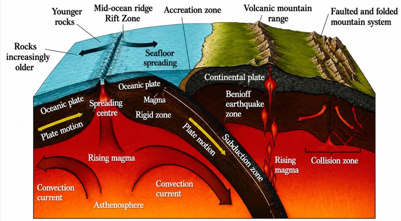
Seafloor spreading does not lead to the enlargement of the crust. This is because as the new seafloor gains materials at the mid ridge it also loses the old ones in the deep trenches where the crust of the new flow moves downward to the mantle, melts and becomes part of the mantle which will eventually be forced out in the form of volcanicity. Through this process, the continents carried above are forced to move along it (Figure 1.6).
|
Figure 1.6: Processes and features of seafloor spreading |
Evidence of Seafloor spreading
There are several evidence that support seafloor spreading theory namely, presence of oceanic ridges, rifts, differences in the ages of rocks along the seafloor and magnetic cyclic.
Presence of oceanic ridges
A mid-oceanic ridge is a seafloor mountain system formed by plate tectonics. Typically, it has the depth of 2600 metres and rises about two kilometres above the deepest portion of an ocean basin. It is this feature that seafloor spreading takes place causing a divergent plate boundary.
Presence of fractures and rifts at the mid oceanic ridge
The centre of the mid ocean is marked by a deep and steeply walled valley. It is believed that this is the valley through which the molten rock comes up through from the mantle.
The molten materials cool and harden to become part of the ocean floor. The addition of these materials creates new crust on each side of the mid ocean ridge. This process is manifested through the spread of the seafloor of Atlantic and Indian Oceans, the presence of oceanic trenches which form as the seafloor buckles in response to the outward push of the molten rock and evidence from seismic devices which show that crust is being downward in the trenches.
Differences in ages of rocks along the seafloor
Exploration of the mid ocean ridge has shown that rocks at its centre are younger than rocks in the seafloor on either sides. Thus, a move away from the ridge in either direction marks an increase in the age of the rocks of the seafloor.
Furthermore, evidence show that seafloor rocks are younger than continental rocks. The youngest rocks along the seafloor are along the rifts of mid oceanic ridges and older rocks are found further away from mid-oceanic ridges.
Magnetic evidence:
In molten rocks, iron atoms move about and point to the magnetic poles of the time. After cooling and solidification, iron atoms are locked in one place. Rocks of different ages show different directions to magnetic poles, thus, rocks that hardened at different times show different directions in mid oceanic ridges. It should be noted that magnetic poles have been discovered to be reversing from year to year. That is to say, a magnetic pole can be in the South for a particular period of time and then in the North for another period of time. It is therefore claimed that there have been 171 reversals in over 76 million years. Therefore, if basaltic lava is formed when the magnetic pole was in the North, new basalt iron atoms would be aligned to the North. After the reversal, new lava would be oriented to the South.
Presence of oceanic trench:
This is an indicator that subduction has taken place after seafloor spreading.
Strength of the Seafloor spreading theory
The Seafloor spreading theory explains the features of the seafloor as it offers reasons for the presence of oceanic ridges, rifts along the oceanic ridges, formation of deep trenches as well as the reasons for seafloor spreading. It also helps us to understand the causes of lithosphere movement. However, the theory fails to explain the mechanism that would allow continents to move through ocean basins.
www.learninghubtz.co.tz
Exercise
1. With examples from Africa, support the continental drift theory.
2. Explain the forces behind continental drifting.
3. Elaborate the continental drift “continents are restless”.
4. Discuss the strengths and weaknesses of the continental drift theory.
5. How does seafloor spreading theory connect to continental drift theory?
6. Show how the seafloor spreading theory explains the formation of landforms.
7. Discuss the strengths and weaknesses of the seafloor spreading theory.
Plate tectonic theory
Geologically, the word plate means a slab of a rock made up of continental and oceanic lithosphere. The word tectonic comes from the Greek word tekton which means “a builder or to build”. The development of plate tectonic theory began in 1915 following the early criticism of Continental drift theory. Essentially, plate tectonics are geological components of study related to the origin and arrangement of the broad structural features of the earth’s surface including not only folds and faults but also mountain belts, continents and earthquake belts. The basic idea of plate tectonics is that the lithosphere (earth’s crust and the upper rigid part of the mantle) is divided into separate parts called tectonic plates, which move slowly. At present it is believed that there are seven (7) large plates and about thirteen (13) or more small plates, making a total of about twenty (20) plates or more.
The major plates
The seven major plates are:
(a) North American plate – It includes the surrounding oceanic crust up to the mid Atlantic ridge.
(b) South American plate – It includes the surrounding oceanic crust up to the mid Atlantic ridge.
(c) Pacific Plate – This plate is the largest of all covering about one-fifth of the earth’s surface, hence occupies the whole of Pacific region.
(d) Eurasian plate – It is a continental plate, thus it occupies both Europe and Asia continents and includes their surrounding areas.
(e) Antarctic Plate – It covers the Antarctica continent and the surrounding Southern Ocean.
(f) African plate – It takes all of Africa and its surrounding area to the mid Atlantic ridge.
(g) Australian–Indian plate – This includes the continental crust of India and Australia as well as the oceanic crust of India and parts of Pacific Ocean.
The minor plates
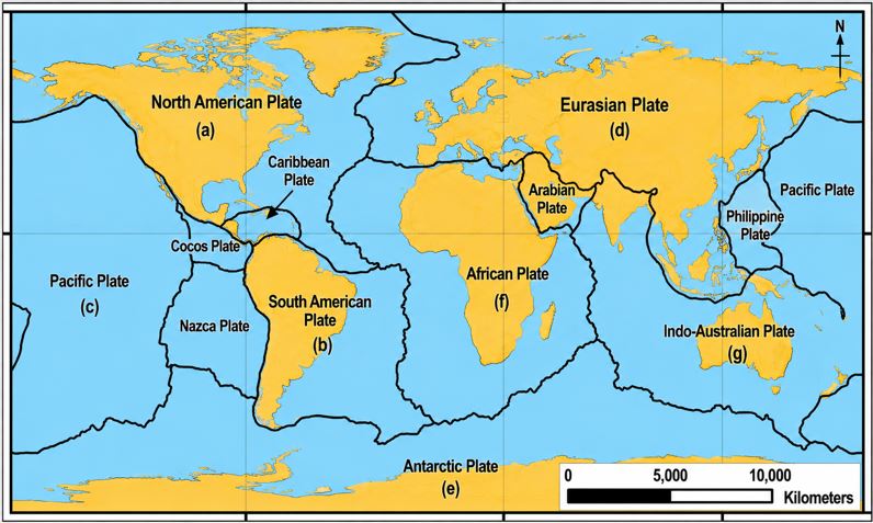
The minor plates are greater in number than major plates reaching to about 13. They include; Caribbean, Philippine, Arabian, Nazca, Cocos, Scotia, Caroline, Somali, Fuji, Burma, New Hebrides and Juan de Fuca plates (Figure 1.7). These plates move over the hot and partially molten asthenosphere though their speed is low.
|
Figure 1.7: Major and Minor Plates |
Assumptions of the plate tectonic theory
The plate tectonic theory states that the earth’s crust is divided into separate parts called tectonic plates. These plates are mobile and they float on underlying semi molten mantle (the asthenosphere) and are moved by convectional currents.
The theory can also be used to be the study of the movement of the plates and their resultant landforms. The plates are divided into two types which are continental and oceanic plates.
Continental plates
These are plates which carry the continents also known as continental mass. They are composed of old rocks mainly over 1500 million years and lighter rocks of granitic type dominated by minerals rich in silica and aluminium (sial). The continental plate of Africa, North America, and South America are good examples of continental plates with old rocks.
Oceanic plates
These are made up of simatic younger and denser rock of basalt composition, dominated with silica and magnesium minerals. They are younger mainly under 200 million years. The boundary between the crust (continental or oceanic) and the underlying mantle is known as Moho or Mohorovicic discontinuity and it was named after a study conducted by Andrija Mohorovicic in 1909.
Causes of plate movement
The causes of plate movement are mantle convectional current generated by heat from the centre of the Earth, formation of new oceanic crust, cooling and sinking of oceanic crust, differences in force of gravity between the oceanic ridge and trench and oceanic topography (elevation of the mid oceanic ridge).
Mantle convectional current
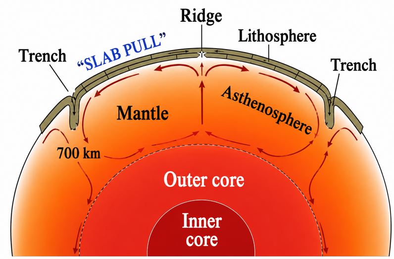
Radioactivity generated heat in the upper mantle produces convectional currents which carry plates along them with the continents as passengers. The heated material in mantle expands and becomes less dense and slowly rises. When it reaches near the crust, it cools down slowly and contracts; hence it becomes dense and sinks down again (Figure 1.8). The new oceanic crust gradually cools down and thickens with age and it is pushed downhill as new magma emerges from the active zones of divergence behind it. This force is regarded as gravity force.
|
Figure 1.8: Mantle convectional current |
Formation of new oceanic crust
New oceanic crust is formed at the mid oceanic ridge as the magma comes to the earth’s crust. The magma rises through the cracks on the plates and cools to form new crust. As the newly formed crust cools down and becomes denser, thus causing the sea bed to sink to subduction zone. As it moves down into subduction zone, the crust is pushed down under another plate. It bends down and sinks into the mantle, thus keeping the plates moving.
Differences in forces of gravity between the oceanic ridge and oceanic trench
The existing differences of gravitational pull between the ridge and trench causes the ridge to be pulled down to the deep trench, hence causing the motion of the plates.
Oceanic topography
Oceanic topography is also known as elevation of the mid oceanic ridges. When the elevated parts of the oceanic floor is subjected to extra weight it results into sinking of the materials which in turn lead to plate motion. As plates move, they can either collide, move apart or slide past each other and result into the formation of various landforms such as mountains, trenches, earthquakes, volcanoes, and mid oceanic ridges.
Plate movement and resulting landforms
Tectonic plates move slowly over time. Some plates move towards each other forming a convergent movement. At a time, some plates move away from each other forming divergent movement, while other plates may also move horizontally and past each other and form a transform movement. The movement of plates creates plate wrinklings or tectonic boundaries from which landforms formation occur.
However, due to its relatively low density, continental crust does not sink but floats permanently on a denser oceanic plate.
Oceanic crust is being formed and destroyed continuously. Continental plates, such as the Eurasian plate, may consist of both continental and oceanic crust, the Earth is neither expanding nor shrinking in size. Thus, when new oceanic crust is being formed in one place, older oceanic crust must be destroyed in another part. Continental crust may extend far beyond the margins of the land masses. Plates cannot overlap. This means that either they must be pushed upwards on impact to form mountains or one plate must be forced downwards into the mantle and destroyed.
Moreover, plate movement is slow, though not in geological terms, and is usually continuous. Sudden movements are detected as earthquakes. Most significant landforms (fold mountains, volcanoes, island arc, deep sea trenches and batholith intrusions) are found at plate boundaries. Very little change occurs in plate centres (shield lands).
The plate margins
These are important regions, zones or boundaries where plates either meet, slide or move apart from one another. The margins are also active seismically and tectonically. Plate margins are characterized by a combination of tectonic and topographic features such as oceanic ridges, Benioff zones, young fold mountains, and transform faults.
Plate boundaries can be classified into three main types which are divergence, convergence and transform/conservative/shear boundaries.
Divergence plate boundary
This boundary (zone) is also known as constructive zone. It is a zone whereby two plates move away from each other. They are called constructive zones because new materials from the interior part of the earth are added to the surface and form new features like the mid-ocean ridge, island arcs, and new oceanic crust. A divergence zone can be found among continental plates (Figure 1.9a), oceanic plates (Figure 1.9b) and continental and oceanic plates. When divergence occurs in the ocean floor no gap is left on the ocean floor as new crustal material from mantle fills them.
Moreover, when divergence occurs on the continent, the continent breaks up and drift apart and the central block subsides. For instance, the land giant through such as the Great Rift Valley in Africa were formed when plates moved apart. The continent to continent divergence zones are associated with different features.
|
Figure 1.9: Divergent plate boundary |
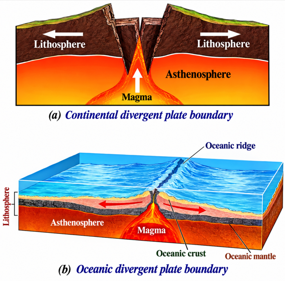
Formation of rift valley occurs if the divergence boundary is on the continental land. A good example is the Great East African rift valley. Volcanic features like volcanic mountains, such as Mount Kilimanjaro in Tanzania, are formed as magma forces along the faults.
A divergent zone on oceanic to oceanic boundary is associated with formation of oceanic ridges if two oceanic plates move away from each other. An example of this formation is the Mid Atlantic Ridges which are 1000 km long and 2500 metres high.
The formation of a rift valley at the mid-oceanic ridges happens when the oceanic ridge breaks at the centre. The Atlantic Oceanic trench is an example of seafloor spreading. It was formed due to the divergence of South America and African plates. Moreover, volcanic islands are formed from the rising submarine volcano at divergent zone that solidified to form an island. Volcanicity and shallow earthquakes are also resulting features at divergent zones on oceanic boundary.
Convergence plate boundary
The convergence plate boundary is also known as a destructive or consuming plate margin. This occurs when two plates move towards each other and result into the formation of trenches such as Marianas, fold mountains like Himalaya and volcanic islands like Japan. Convergence boundary is divided into three main categories namely;
- continental–oceanic,
- continental–continental, and
- oceanic–oceanic convergence boundaries.
Continental–oceanic convergence boundary
The continental–oceanic convergence boundary forms when oceanic floors (plate) and continental plate meet. As they meet, the heavier rocks (oceanic floor) will be forced to sink (making subduction zone) while the lighter continental rock will be forced to rise. The sinking oceanic rock will be destroyed in hot mantle and come out in the form of volcano (Figure 1.10). The subduction zone is active in volcanicity and earthquake zones. Examples of these include Java Trench and Mariana Trench which were formed when the Philippine Plate subducted under the Pacific Plate.
|
Figure 1.10: Continental–oceanic convergence boundary |
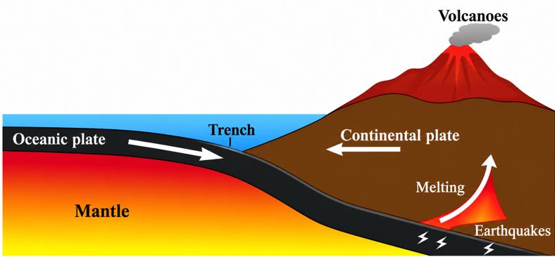
Continental–continental convergence boundary
Continental–continental convergence boundary is the zone where two similar plates (continental and continental) collide such that neither of them sinks below the other; rather they are forced to bend, leading to the formation of fold mountains such as the Himalayas, Alps and Atlas (Figure 1.11). It is also known as a destructive zone because the plates tend to lose the materials at their margins where collision occurs.
|
Figure 1.11: Continental–continental convergence boundary |
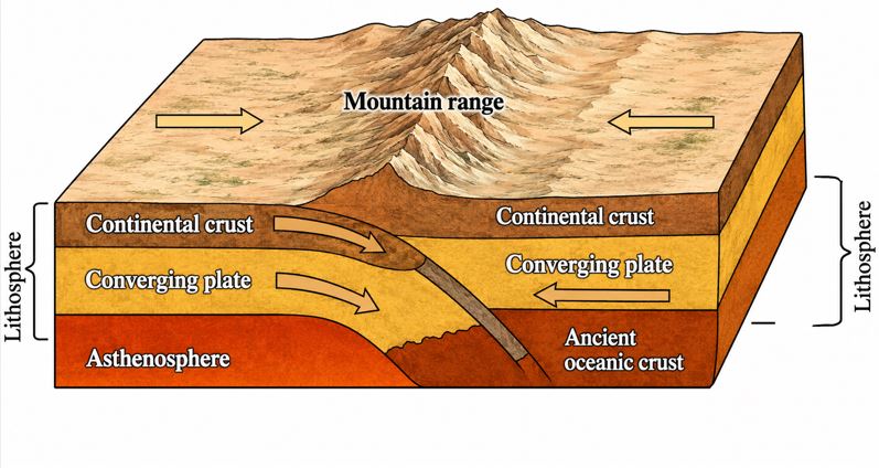
Oceanic–oceanic convergence boundary
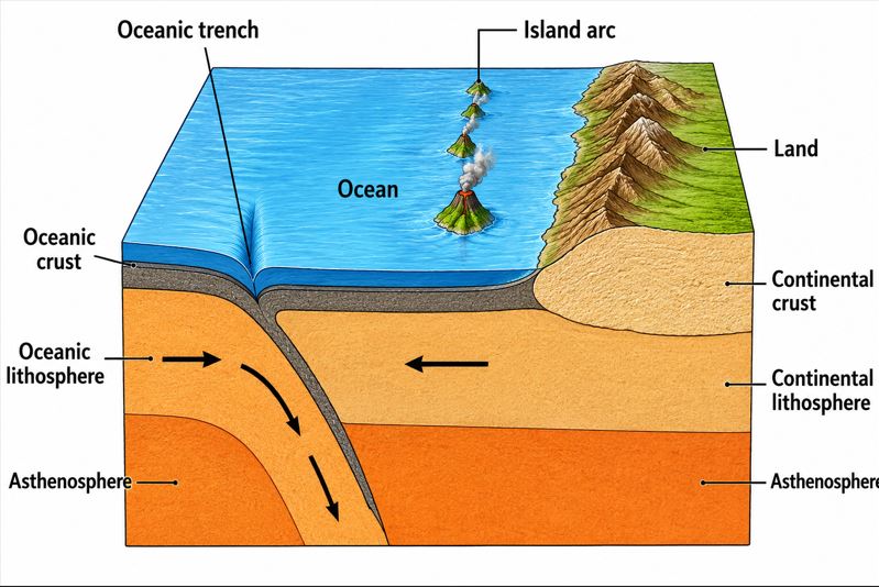
Oceanic–oceanic convergence boundary occurs when two oceanic plates converge and one is subducted beneath the other along an oceanic–oceanic plate boundary. Specifically, it happens when one oceanic plate is slightly denser than the other (Figure 1.12). On the non-subducted plate, a volcanic island arc forms from the rising magma generated from the subducting plate. A good example is an island arc of Japan and West Indies.
|
Figure 1.12: Oceanic–oceanic convergence boundary |
Transform boundary
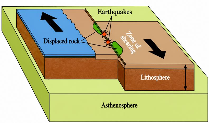
Transform boundary is also known as conservative or tear (shear) plate boundary. This occurs when two lithospheric plates slide past each other along a transform fault (Figure 1.13). During that process neither plate is created nor destroyed.
As a result, transform faults which are accompanied by tremors and earthquakes may occur. Examples of faults in the transform boundaries are the San Andreas Fault in California and the North Anatolian Fault in Turkey.
|
Figure 1.13: Transform boundary |
| Activity 1.4 Search for appropriate readings from school library or online platforms about plate tectonic theory. Write a summary elaborating the applicability of the theory in explaining the formation of landforms on Earth. |
www.learninghubtz.co.tz
Exercise
1. Explain how the Plate Tectonic Theory accounts for the formation of the following landforms:
- Fold mountains
- Rift valleys
- Mid-ocean ridges
- Deep-sea trenches
- Volcanic islands
2. "The Plate Tectonic Theory provides a better explanation of the Earth's structural features than the Continental Drift Theory." Discuss this statement.
3. Assess the role of mantle convection currents in the movement of tectonic plates and the formation of various landforms.
4. With the aid of well-labelled diagrams, examine the characteristics of divergent, convergent and transform plate boundaries and explain the landforms associated with each.
5. Explain the causes of plate movement and show how each contributes to the continuous movement of tectonic plates.
6. Using examples from different parts of the world, examine the processes and landforms associated with:
- Continental–continental convergence
- Continental–oceanic convergence
- Oceanic–oceanic convergence
7. Explain why earthquakes and volcanoes are concentrated along plate boundaries despite the slow movement of tectonic plates.
8. Evaluate the relevance of the Plate Tectonic Theory in explaining geological phenomena and solving environmental challenges in Africa.
9. Substantiate the contention that plate tectonic theory is a new version of a continental drift theory.
10. Relate the theory of plate tectonics with landforms formation in Africa.
Isostasy theory
This theory was proposed by Clarence Dutton, an American Geologist in 1889.
The term isostasy is derived from two Greek words isos which means equal and stasis which refers to the state of equilibrium or balance or standing still. Literally, isostasy refers to equal standing. Generally, the theory explains the tendency of the earth’s crust to attain an equilibrium state and the distribution of the materials in the earth’s crust which conforms to the observed gravity values.
Assumption of the Isostasy theory
The theory assumes that the earth’s crust is floating on the molten rocks of the upper mantle, like a raft floating in the water rather than resting on the mantle like a raft sitting on the ground.
The theory states that, the lithosphere which has a constant density of 2.7 grams per cubic centimetre, floats in the asthenosphere which has a constant density of 3.3 grams per cubic centimetre. It further states that, there is a state of gravitational equilibrium between the earth’s lithosphere and asthenosphere, in such a way that the tectonic plates floating at an elevation depend on their thickness and density (Figure 1.14). This means that, a continental rock (sial – silica and aluminium) has low density, underlie denser oceanic rocks (sima – silica and magnesium) which results to a state of balance.
|
Figure 1.14: Lithosphere floating on asthenosphere |
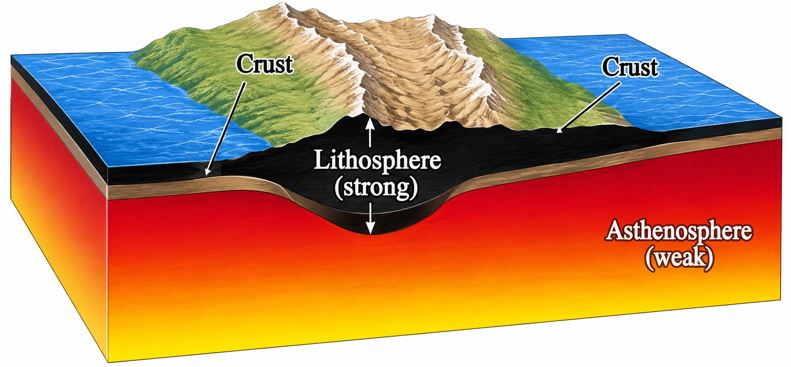
The theory further states that, where the continental masses (Sial) rise to form a mountain, the penetration of ice below is greater to compensate the excess mass. Moreover, where the continental mass is thin, like Sima layer draws near the surface or reaches the surface of the Earth and form the ocean floor.
The principle of buoyant force is proportional to the depth of its root. Hence, the deeper the root the higher the mountain. This state or balance between different parts of the earth’s crust is called isostasy where equal mass underlies equal surface area. This concept helps to explain the existence of different topographic heights on the earth’s surface.
The theory further states that any disturbance or restoration in the earth’s crust will cause a sinking and uplifting movement of the Earth in order to balance itself. The disturbance can either be erosion or melting of the accumulated snow while restoration can be deposition or accumulation of large snow or a volcanic hill. The theory therefore describes the state of balance achieved between erosion and deposition.
Analogy of Isostasy theory
Analogy of Isostasy theory may be made with things like; floated icebergs, floated pieces of wood, and loaded and unloaded ships.
(a) Floated iceberg
An iceberg or ice mountain is a large piece of freshwater ice that has broken off a glacier or an ice shelf and it is floating freely in open water. It may subsequently become frozen into pack ice (see “crust of sea ice”). An iceberg always floats with a certain proportion of its mass below water surface.
The portion below water surface is compensation portion (Figure 1.15). If a layer of ice is somehow sliced off on the top of the iceberg, the remaining iceberg will rise. Similarly, the earth’s lithosphere floats on the asthenosphere the same as the iceberg floats on water.
|
Figure 1.15: Iceberg floating in water |

Floated pieces of wood
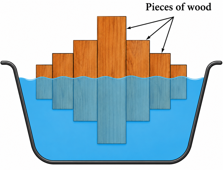
The idea of isostasy may be grasped by considering a series of wooden blocks of different heights floating in water. If such woods are immersed in water, the longer one will sink down more than the short one (Figure 1.16). Therefore, when wooden blocks are submerged, the height of the submerged part of the pieces is proportional to their respective emerged parts.
|
Figure 1.16: Proportions of submerged pieces of wood to the respective emerged parts |
Loading and unloading ships
Floating ships show how isostasy affects the behavior of the crust as it floats on the heavy mantle rock. For instance, when cargo is transferred from ship “A” to ship “B”, ship “A” floats higher in the water and ship “B” floats lower. This happens as a response to the process of loading and unloading of cargo (Figure 1.17).
|
Figure 1.17: Compensation process |
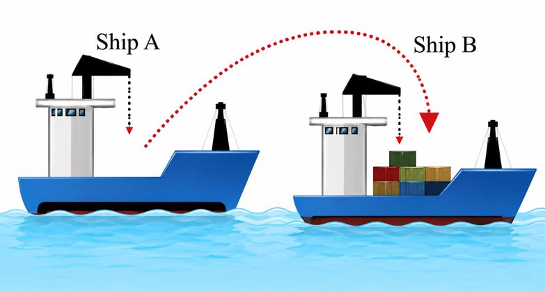
The Earth maintains its balance in the same way as ships. The process of loading and unloading of the eroded materials of the earth’s surface disturbs the balance on the Earth, therefore, the process of compensation takes place to restore it. The restoration process is extremely slow as it happens over thousands of years.
Isostatic movements and resulting landforms
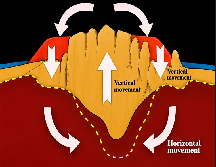
There are two main movements of isostasy namely; vertical and horizontal movements. Vertical movement is also known as the movement of weight while horizontal movement is referred to as the movement of heat accumulation.
Vertical movement
It involves upward and downward movements of materials which enhance isostatic readjustment. The process is slow and takes thousands of years in maintaining the balance between oceanic mass and continental rocks.
The existence of vertical movements can be indicated in various parts of the world, especially in the poles in connection to the formation of ice (ice age) and its melting. Therefore, it is evidenced that, when the great ice caps are formed, the weight of ice causes the sinking or sagging of the crust, and when the ice melts, recovery gradually takes place, thus producing considerable changes in the level of the land relative to that of the sea.
Examples of vertical movement can be evidenced in different parts of the world including, the continental shelf of Antarctica which is deeper than others as its water depth is about 750 metres compared with 180 metres around other continents. This may be a result of the weight of the present ice sheet.
Another example is the ice cap of Greenland whose landscape is covered by enormous weight of ice. Unless otherwise, the surface of underlying plateaus would be 1100 metres higher.
Furthermore, changes in weather and climate in northern Europe caused disappearance of ice sheets which caused a raised land and formed a beach in Scandinavia.
As the weight of continental rocks increased due to restoration, it resulted into extra weight which disrupted the balance in the area and finally caused the sinking.
Several reasons cause extra weight including volcanic eruption, deposition of sediments, accumulation of snow and ice, the decrease of continental rock weight as well as denudation and melting of ice.
Volcanic eruption
The outpouring of lava due to volcanic eruption that forms volcanic mountain/arch may cause extra weight, hence a sinking movement.
Deposition of sediment
When large amounts of sediments are deposited on a particular region, the enormous weight of the new sediments may cause the crust below to sink.
Accumulation of snow and ice
The formation of ice sheets and the falling of snow for instance in the northern hemisphere like Arctic, Alaska, Greenland, Siberia or Antarctica in the South Pole have caused the earth’s surface to sink.
The decrease in continental rock weight
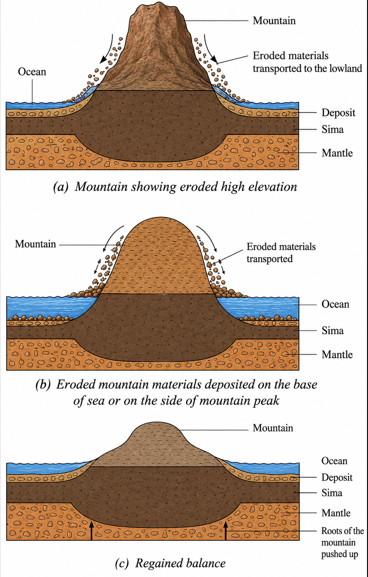
If the weight of continental rocks is decreased because of erosion/denudation at the mountain and melting of ice in one area, it results in the uplifting of a given area.
Denudation
When large amounts of materials are eroded away from a region, the land may rise to compensate the lost height and weight. Therefore, as a mountain range is eroded away, the reduced range rebounds upwards to a certain extent (Figure 1.18 a, b and c).
(a) Mountain showing eroded high elevation
(b) Eroded mountain materials deposited on the base of sea or on the side of mountain peak
(c) Regained balance
|
Figure 1.18: Isostatic movements |
Melting of ice
Isostatic post glacial rebound is observed in areas once covered by ice sheets which have now melted. Example are found around the Baltic-sea and Hudson Bay. As the ice retreats, the load on the lithosphere and asthenosphere is reduced and they rebound back towards their equilibrium levels. In this way it is possible to find former sea cliffs and associated wave-cut platforms hundreds of metres above present day sea level. The rebound movements are slower such that the uplifting caused by the ending of the last glacial period continues.
Horizontal movement
This occurs when there is a horizontal flow of material from the depressed area to the uplifted area for adjustment. The adjustment involves a horizontal flow or convection current that involves accumulation of heat. It takes place in the simatic layer, especially in the asthenosphere where there is maximum plasticity (Figure 1.19). There is a continuous radioactive disintegration within the simatic layer specifically in the asthenosphere. The disintegration releases heat which may be accumulated and prevented by overlying more solid layer from escaping the earth’s surface through radiation. The heat, therefore, makes the sima mobile resulting to the sinking of the sialic continents, once periodic ocean transgression. On the other hand, if it happens that, the accumulated heat is degenerated due to various processes such as widespread volcanic activities, the sima becomes less fluidity and continents begin to rise. Therefore, it produces a regression of the sea, hence the exposure of former seafloor. These major transgressions and regressions in the Earth are affected by the warping and tilting of the sialic blocks.
|
Figure 1.19: Combined isostatic movements |
The evidence of isostatic movement on earth’s surface
The evidences of isostatic movements can be seen in different parts of the world as explained below:
Presence of raised beach
The raised beach in Scandinavia which was covered by a vast ice sheet about 10000 years ago is still rebounding isostatically at the rate of up to 1 metre per century. The result is the formation of raised beaches which lie between 8–30 metres above present beaches. Similarly, the Ballyhillin beach in Ireland is rebounding isostatically to form raised beaches.
The evidence of coastal cities in Scandinavia as old constructed dock, have been uplifted rapidly enough and the docks which were constructed several centuries ago are now far from the shore. The coastal areas are rebounding to maintain balance due to the areas covered by vast ice sheet during ice age. Moreover, in East Africa, this raised beach was witnessed through past studies. For example, studies conducted in the 1970’s marked some evidence of the raising shore line in Mombasa coastal area, in Kenya.
Depression formation
This is another evidence which means landform sunk below the surface area. Depressions may be formed by various mechanisms such as erosion-related. With this one, features like blowouts are created by wind erosion typically in either a partially vegetated sand dune ecosystem or dry soils. Moreover, area of subsidence caused by the collapse of an underlying structure such as sinkholes in karst terrain. In Greenland and Antarctica, the surface has been depressed below sea level by the weight of a glacial ice so as to maintain balance.
Land uplift
This is another evidence with which isostatic rebound has also occurred in different areas. For example in the eastern and central Canada and southern Ontario where the land has risen as much as 100 metres in the last 600 years. During the ice age, the weight of the glaciers depressed the surface of the land. The depressed land began to rise when the glacier melted because of the isostatic readjustment.
Deformity of continental shelf
An example of this evidence is the continental shelf around Antarctica, converted with water to a depth of about 500 feet (750 metres) compared with 600 feet (180 metres) around other continents. This may be a result of the weight of the present ice. The current Antarctic ice sheet acts as surface load causing deformation of the Earth. This explains why continental shelf of Antarctica is deeper than that of the entire Antarctica continent including the subsided continental shelf due to the presence of Antarctic ice sheet as a significant load on the earth’s surface compared to other continental shelf in the world. The Antarctic continent is almost isostatic equilibrium.
Existence of mountain ranges
Despite the continuous processes of erosion, several mountains have maintained their heights. For instance, Mt. Kilimanjaro has maintained its height of about 5895 metres above sea level for thousands of years.
Existence of water bodies
Despite the continuous deposition activity which accumulate and deposit millions of tons of materials, water bodies like Indian Ocean, Lake Victoria, and Lake Tanganyika have not disappeared. There is also, the emergence of emerged coast formed as a result of land uplift around the coast of Scandinavian countries.
Significance of Isostasy theory
Several implications of the Isostasy theory can be provided. However, the most significant ones are; the theory signifies the state of equilibrium in the earth’s crust with equal mass underlining equal surface area. Therefore, it gives an understanding on the earth’s crust dynamic state as it is influenced by internal and external forces. Also, the relationship which is made as the crust floats on mantle just like the iceberg on the ocean or seawater is important in the understanding of plate tectonic and continental drift theories. Precaution can be taken depending on the nature of the climatic condition of a given area especially in the occurrence of ice sheet and the melting of ice. Furthermore, it provides a basis for predicting the future of the crustal state at any place on the earth’s surface and understanding how different landforms are formed and the mechanisms involved in their formation.
The effects of isostatic movements
The isostatic movements causes several effects on the earth’s surface. The vertical and horizontal movements of isostasy result into occurrences of faulting and folding of the earth’s crust. Faulting and folding have a prolonged impact of causing rift valleys, mountains as well as volcanic eruptions with their associated features. Despite the geomorphological effects of the Isostasy theory, still it is criticized due to its failure to explain the formation of inland and undersea mountains or the presence of volcanic islands.
| Activity 1.5 Read books and other online sources, then write a summary elaborating the weaknesses of the following theories:
|
www.learninghubtz.co.tz
Revision exercise
1. As a geographer student, why do you think it is necessary to learn about theories of landforms formation?
2. Examine the interrelationships between erosion and deposition in the context of isostatic balance.
3. “Isostasy theory has never been realistic.” Argue for or against this view.
4. Using examples, explain the observation made by Alfred Wegener to support his continental drift theory.
5. Substantiate the contention that “isostasy is isostatic adjustment”.
6. How does sea floor spreading theory relate to the plate tectonic theory?
7. Explain why Plate Tectonic Theory is regarded as the most accepted theory of landform formation.
8. Why does the African continent continue to experience tectonic activities?
9. Explain why earthquakes and volcanoes are concentrated along plate boundaries.
10. Examine the role of mantle convection currents in plate movement.
11. Assess the relevance of theories of landform formation in solving environmental and geological problems in Tanzania.

Hub App
 For Call,Sms&WhatsApp: 255769929722 / 255754805256
For Call,Sms&WhatsApp: 255769929722 / 255754805256  MATOKEO YA KIDATO CHA VI 2026
SECONDARY REGIONAL EXAMS
PRIMARY REGIONAL EXAMS
FORM VI NECTA REVIEWS
FORM IV NECTA REVIEWS
FORM II NECTA REVIEWS
STD VII NECTA REVIEWS
STD IV NECTA REVIEWS
SECONDARY EXAMS SERIES
PRIMARY EXAMS SERIES
PRIMARY SUBJECT NOTES
SECONDARY SUBJECT NOTES
SECONDARY TOPICAL EXAMS
SECONDARY TOPICAL QUESTIONS
PRIMARY TOPICAL QUESTIONS
PRACTICAL EXAMS & NOTES
SECONDARY REGIONAL EXAMS
DOWNLOAD SUBJECT NOTES
SCHEMES OF WORK (PRIMARY & SECONDARY)
LESSON PLAN
SECONDARY LOG BOOKS
PRIMARY LOG BOOKS
LITERARY WORKS / UCHAMBUZI VITABU
METHALI ZOTE ZA KISWAHILI
Vitendawili Vya Kiswahili
FORM VI RESULTS 2024
FORM FIVE SELECTION 2024
Matokeo KIDATO CHA II 2024
Matokeo Darasa IV 2024
MATOKEO KIDATO CHA IV 2023
FORM ONE SELECTION 2024
FORM VI RESULTS 2023
Matokeo Darasa IV 2022
MATOKEO YA KIDATO CHA VI 2026
SECONDARY REGIONAL EXAMS
PRIMARY REGIONAL EXAMS
FORM VI NECTA REVIEWS
FORM IV NECTA REVIEWS
FORM II NECTA REVIEWS
STD VII NECTA REVIEWS
STD IV NECTA REVIEWS
SECONDARY EXAMS SERIES
PRIMARY EXAMS SERIES
PRIMARY SUBJECT NOTES
SECONDARY SUBJECT NOTES
SECONDARY TOPICAL EXAMS
SECONDARY TOPICAL QUESTIONS
PRIMARY TOPICAL QUESTIONS
PRACTICAL EXAMS & NOTES
SECONDARY REGIONAL EXAMS
DOWNLOAD SUBJECT NOTES
SCHEMES OF WORK (PRIMARY & SECONDARY)
LESSON PLAN
SECONDARY LOG BOOKS
PRIMARY LOG BOOKS
LITERARY WORKS / UCHAMBUZI VITABU
METHALI ZOTE ZA KISWAHILI
Vitendawili Vya Kiswahili
FORM VI RESULTS 2024
FORM FIVE SELECTION 2024
Matokeo KIDATO CHA II 2024
Matokeo Darasa IV 2024
MATOKEO KIDATO CHA IV 2023
FORM ONE SELECTION 2024
FORM VI RESULTS 2023
Matokeo Darasa IV 2022
WHATSAPP US NOW FOR ANY QUERY
App Ya Learning Hub Tanzania