THE UNITED REPUBLIC OF TANZANIA
NATIONAL EXAMINATIONS COUNCIL CERTIFICATE OF SECONDARY EDUCATION EXAMINATION
013 GEOGRAPHY
(For School Candidates Only)
Time: 3 Hours Tuesday, 4th O ctober 2011 a.m
Instructions 1. This paper consists of sections A, B, C and D.
2. Answer all questions in sections A, B and C and one (1) question from each part of section D.
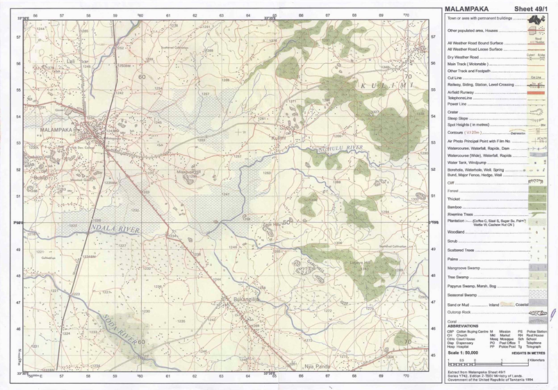
3. Map extract of Malampaka (sheet 49/1) is provided.
4. Credit will be given for the use of relevant sketch maps and diagrams.
5. Calculators and cellular phones are not allowed in the examination room.
6. Write your Examination Number on every page of your answer booklet(s)
SECTION A (25 Marks)
Answer all questions in this section.
PHYSICAL AND MATHEMATICAL GEOGRAPHY 1. For each of the items (i) - (x), choose the correct answer from among the given alternatives and write its letter beside the item number.
(i) One of the following features is a characteristic of coniferous forests:
Trees are made up of hard wood Trees occur in stands Trees favour high temperatures Trees have broad leaves Trees grow in a few years. Choose Answer :
- -
A
B
C
D
E
(ii) The Inter-Tropical Convergence Zone (ITCZ) means
a region of low pressure a region of doldrums a region of high pressure a sub-tropical high pressure belt a region with high speed winds. Choose Answer :
- -
A
B
C
D
E
(iii) Rias often provide natural harbour because they are
found along the sub-merged coast. mainly found in Europe where the sea is shallow deep outlets of water along the coast not deep, ships can approach ports easily similar to lagoons but have shallow depths. Choose Answer :
- -
A
B
C
D
E
(iv) If the local time at town X (30°E 45°N) is 5.00 p.m. Monday, what will the time be at town Y (15°W 50°S)?
2 a.m. Monday 8 p.m. Monday 2 p.m. Monday 3 p.m. Monday 2 p.m. Sunday. Choose Answer :
- -
A
B
C
D
E
(v) The following are instruments used in chain and tape survey:
Barometer, pegs, notebook, compass Tape measure, chain, cross staff, anemometer Chain, arrows, ranging poles, altimeter Arrows, ranging poles, pegs, chain Cross staff, notebook, chain and plane table. Choose Answer :
- -
A
B
C
D
E
(vi) When the river flows in its long profile it performs the following geological activities:
Moves fast and can carry everything on the earth’s surface Erodes, transports and deposits weathered materials Meanders and forms ox-bow lakes throughout the profile Does three functions such as abrasion, solution and attrition Acts as agent of weathering and erosion along the profile. Choose Answer :
- -
A
B
C
D
E
(vii) If the location of a point on a map is given by grid reference 365490, then
365 are Degrees 365 are Longitudes 490 are Northings 490 are Eastings 365 are Northings Choose Answer :
- -
A
B
C
D
E
(viii) The following are the elements of weather:
Soils, clouds, dew, humidity, rainfall Fog, barometer, humidity, pressure, air mass Clouds, sunshine, pressure, humidity, thermometer Pressure, clouds, sunshine, humidity, winds Pressure, humidity, soils, fog. Choose Answer :
- -
A
B
C
D
E
(ix) Which one of the following is not an outcome of the rotation of the earth on its own axis?
Deflection of winds and ocean currents Difference of one hour between two meridians 15° apart Day and night Seasons of the year Sunrise and sunset. Choose Answer :
- -
A
B
C
D
E
(x) Landforms formed by vulcanicity can be divided into
Many parts according to the nature of lava Sills, dykes, valleys and earthquakes only Volcanic mountains and sills only Extrusive and intrusive features Batholiths, dykes and volcano only. Choose Answer :
- -
A
B
C
D
E
2. Match the items in List A with the responses in List B by writing the letter of the correct response beside the item number.
LIST A LIST B (i) Earth’s zone which is rich in Nickel and iron. (ii) Erosional feature which is always formed in the young/upper stage of the river valley.
(iii) Consists of a huge canopy which limits the undergrowth.
(iv) The feel of coarseness or softness of the individual soil particles.
(v) A planet in the solar system with the longest orbit around the sun.
Soil texture Delta Soil structure Mantle Jupiter Coniferous forest Core Pluto Tropical rain forest Interlocking spurs
View Ans 3. Soils may differ from one area but they share almost the same components.
Describe the composition of the soil.
View Ans SECTION B (27 Marks)
Answer all questions this section.
APPLICATION OF STATISTICS, INTRODUCTION TO RESEARCH AND ELEMENTARY SURVEYING
4. Data in the following table show the enrolment of Form One students at Mji Mpya Secondary School from 2006 to 2010. Carefully study them and answer the questions that follow.
Year
2006
2007
2008
2009
2010
Number of students
220
200
150
180
205
(a) Present the data by using simple bar graph.
(b) Comment on the trend of the enrolment.
(c) Explain the advantages of the method you have used in (a) above.
View Ans 5. (a) What is hypothesis formulation?
View Ans (b) Explain four importance of hypothesis in research.
View Ans 6. Form three students at Nguvumali secondary school would like to conduct a simple chain survey around their school compound and measure the height of the big gully near the headmaster’s office. Describe the significance of survey in Tanzania
View Ans SECTION C (28 Marks)
Answer all questions in this section.
MAP READING AND PHOTOGRAPH INTERPRETATION
7. Carefully study the map extract of Malampaka (sheet 49/1) provided and answer the following questions:
(a) Calculate the area covered by seasonal swamps in Km2 .
(b) Explain the distribution of natural vegetation.
(c) How long in kilometres is river Ng’hulu from grid reference 625496 to grid reference 700522?
(d) Identify any three ways which have been used to represent relief in the area.
(e) Through giving evidence, explain any four economic activities that might be taking place in the area.
View Ans 8. Carefully study the following photograph and answer the questions that follow.
(a) Such the type of the photograph by giving two reasons.
(b) Suggest any four economic activities that might be taking place in the area shown on the photograph.
(c) Comment on the nature of the settlement pattern as it is portrayed on the photograph.
(d) Explain the relief of the area.
View Ans SECTION D (20 Marks)
Answer one (1) question from each part.
PART 1: REGIONAL FOCAL STUDIES
9. (a) Distinguish between large scale and small scale farming.
View Ans (b) What are the advantages of large scale over small scale farming?
View Ans 10. “Oil as an economic resource has improved the living standards of the people of Libya”. Discuss.
View Ans PART II: ENVIRONMENTAL ISSUES, POPULATION AND SETTLEMENT
11. Explain the environmental factors which influence population distribution in Tanzania.
View Ans 12. Suggest the measures to be taken in order to reduce the effects of global climate change at national level.
View Ans 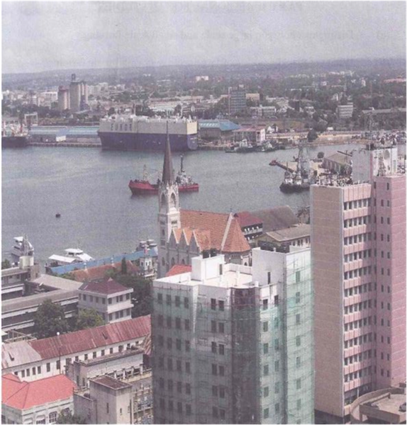

 For Call,Sms&WhatsApp: 255769929722 / 255754805256
 MATOKEO KIDATO CHA IV 2023
FORM ONE SELECTION 2024
Matokeo Darasa VII 2023
MATOKEO KIDATO CHA IV 2023
FORM ONE SELECTION 2024
Matokeo Darasa VII 2023


