THE UNITED REPUBLIC OF TANZANIA NATIONAL EXAMINATIONS COUNCIL
CERTIFICATE OF SECONDARY EDUCATION EXAMINATION
013 GEOGRAPHY
(For Both School and Private Candidates)
TIME: 3 Hours Thursday afternoon 11/10/2007
Instructions
1. This paper consists of sections A, B, C and D.
2. Answer all questions in sections A, B and C and one (1) question from each part of section D.
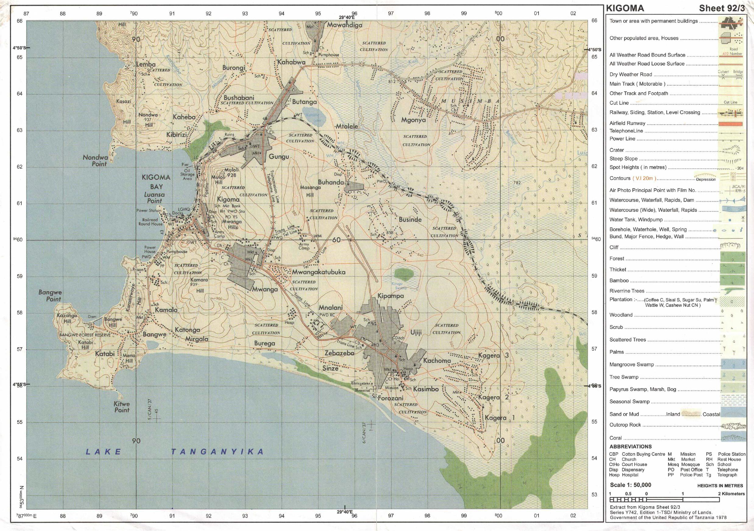
3. Map extract of Kigoma sheet 92/3 is provided.
4. Credit will be given for the use of relevant sketch maps and diagrams.
5. Cellular phones are not allowed in the examination room.
6. Electronic calculators are not allowed in the examination room.
7. Write your Examination Number on every page of your answer booklet(s)
SECTION A (25 Marks)
Answer all questions in this section.
PHYSICAL AND MATHEMATICAL GEOGRAPHY
1. For each of the items (i) - (x), choose the correct answer from among the given alternatives and write its letter beside the item number.
(i) Clay as a parent rock can be classified as __________ rock.
pervious
porous
permiable
impermiable
permiable and impermiable
Choose Answer :
(ii) Circular depressions which are formed by glaciations in the highlands are
caldera
craters
cirques
hanging valleys
aretes.
Choose Answer :
(iii) A drainage pattern, which looks like a tree with its branches is called
trellised
dendritic
radial
centripetal
annular.
Choose Answer :
(iv) The second layer of the earth’s crust is known as
sial
sima
mantle
core
gotenburg gap.
Choose Answer :
(v) Wadis, Bajada, Buttes and Mesa are examples of __________ features.
wind erosion and deposition
glacial erosion and deposition
wave erosion and deposition
desert water erosion and deposition
river erosion and deposition
Choose Answer :
(vi) Which one of the following combinations form chemical weathering?
Organic acid and weak carbonic acid.
Temperature change and frost action.
Exfoliation and carbonation.
Mud flow and land slides.
Organic acid and temperature change.
Choose Answer :
(vii) A vertical feature formed out of the solidification of magma within the earth’s crust is called
phacolith
sill
dyke
lopolith
lacolith.
Choose Answer :
(viii) A coral reef with a circular elliptical shape enclosing a lagoon is called
fringing reef
barrier reef
lagoon
atoll
planktons.
Choose Answer :
(ix) If the temperature at 500 metres where the tourists start climbing mount Kilimanjaro is 20°C. What will be the temperature when they reach 2,000 metres above sea level?
10°C.
5°C.
11°C
12°C
15°C.
Choose Answer :
(x) The process in which a river renews its erosion in its valley is called
regime
rejuvenation
capture
cavitation
abrasion.
Choose Answer :
2. Match the items in List A with the responses in List B by writing the letter of the correct response besides the item number.
List A
List B
(i) The galaxy from which the solar system containing the planet earth is found.
(ii) A large area on the earth’s surface with uniform characteristics of temperature, rainfall and vegetation.
(iii) A thin blanket of air surrounding the earth.
(iv) A process that course the wrinkling of the earth’s surface rocks.
(v) The destruction of rocks by temperature change.

 For Call,Sms&WhatsApp: 255769929722 / 255754805256
 MATOKEO KIDATO CHA IV 2023
FORM ONE SELECTION 2024
Matokeo Darasa VII 2023
MATOKEO KIDATO CHA IV 2023
FORM ONE SELECTION 2024
Matokeo Darasa VII 2023


