PRESIDENT’S OFFICE, REGIONAL ADMINISTRATION AND LOCAL GOVERNMENT
SECONDARY EXAMINATION SERIES,
PRE MOCK EXAMINATION
GEOGRAPHY FORM FOUR
Time: 3Hours
Instructions
- This paper consists of sections A, B, and C with a total eleven (11) questions.
- Answer all question in the sections A, B and two (2) questions from section C.
- Section A carries sixteen (16) marks, section B fifty four (54) marks and section C carries thirty (30) marks.
- All writing should be in blue or black pen, except for diagrams that must be drawn in pencil.
- Communication devices and any unauthorized materials are not allowed in the examination room.
- Write your Examination Number on every page of your answer booklet (s
SECTON A (16 MARKS)
- Choose the correct answer from among the alternative given.
(i) Which of the following planets has the most moons?
- Mercury
- Venus
- Earth
- Mars
- Jupiter
(ii) The layer of the Earth that is responsible for plate tectonics is the:
- Crust
- Mantle
- Outer Core
- Inner Core
- Atmosphere
(iii)The average weather conditions of a place over a long period is referred to as:
- Precipitation
- Humidity
- Climate
- Air pressure
- Wind speed
(iv) On a topographic map, brown contour lines indicate areas of:
- High elevation
- Low elevation
- Water bodies
- Dense vegetation
- Urban areas
(v)The process by which rock is broken down into smaller fragments without chemical change is called:
- Erosion
- Weathering
- Volcanism
- Metamorphism
- Sedimentation
(vi) The layer of soil with the highest concentration of organic matter is the:
- A-horizon
- B-horizon
- C-horizon
- O-horizon
- R-horizon
(vii) The breakdown of rock by the action of freezing and thawing water is an example of:
- Chemical weathering
- Physical weathering
- Biological weathering
- Erosion
- Sedimentation
(viii)The process by which wind removes loose particles from the Earth's surface is called:
- Deposition
- Erosion
- Weathering
- Mass wasting
- Compaction
(ix) Which of the following instruments is used to measure horizontal angles?
- Theodolite
- Level
- Clinometer
- GPS receiver
- Tape measure
(x) A soil with a good balance of sand, silt, and clay particles will have good:
- Drainage
- Aeration
- Water holding capacity
- All of the above
- None of the above
2. Match the description for a extrusive feature formed on the earth surface ON LIST A with the correct term in LIST B.
| LIST A | LIST B |
| A. Shield volcano B. Lava dome C. Caldera D. Cinder cone E. Volcanic fissure F. Tephra
|
SECTION B: 54 Marks
3. Study the map extract of KIGOMA (sheet 92/03) provided and then answer following questions.
(a) Comment on the settlement patterns on the mapped area
(b) Show any two methods which have been used to determine the elevation of the mapped area
(c) By using grid method, find the area of Lake Tanganyika from grid 60 northward of mapped area
(d) Examine four land use of Kigoma area.
4. Describe the following features;
- Snowline
- Moraine
- U-shaped valley
- Glaciated landform
5. Explain four main factors that influence soil formation.
6. Juma wants to use chain survey to carry out his survey work. Explain to him the advantages and disadvantages of using simple chain survey.
7. Study the photograph below and answer the questions that follow.
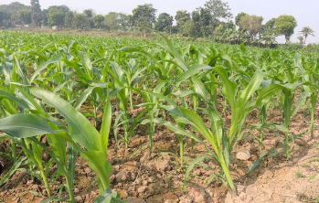
- Name the crop shown on the Photograph
- Mention the climatic conditions which favor the growth of the crop
- Name at least three regions in Tanzania where this crop is grown in large scale
- With concrete evidence, explain the possible scale of production of the crop as shown on the photograph
- What are economic potentials of this crop for the farmers of this region.
8. The Ministry of Education of United Republic of Tanzania under National Examination Council of Tanzania past five years was in a research about why there was mass failure of pupils in primary schools. This made the government to take sample schools to make a research.
a) As a student who studied a research topic, give only five reasons why the ministry decided to use sample of schools to complete its research instead of taking all primary schools?
b) (i) Briefly explain the tool of data collection that is bias and it suits only to literate people or respondents.
(ii) Which tool needs a researcher to create a friendship atmosphere with a respondent before starting the collection of data?
SECTION B: 30 Marks
Answer all questions in this section
9. Explain the contribution of mining to the economy of Tanzania
10. What lessons can Tanzania learn from tourism industry in Switzerland and Namibia.
11. Most of African countries established birth control and international migration policy as among the methods of controlling rapid population growth. As a form four student, do you think there is any problem of population increase in these countries? Give six points.
FORM FOUR GEOGRAPHY EXAM SERIES 191
FORM FOUR GEOGRAPHY EXAM SERIES 191
PRESIDENT OFFICE REGIONAL ADMNISTRATION
AND LOCAL GOVERNMENT
SECONDARY EXAMINATION SERIES
COMPETENCE BASED ASSEMENT
GEOGRAPHY FORM FOUR
TERMINAL EXAMS MAY – 2023
013
TIME: 3HOURS
INSTRUCTIONS:
- This paper consists of section A, B and C with a total of eleven (11) questions
- Answer all questions in sections A and B and two questions from section C.
- Section A carries fifteen (16) marks, section B carries fifty five (54) marks and section C thirty (30) marks.
- Map extract of Kigoma (sheet 92/3) is provided.
- Write your examination number on every page of your answer sheet.
SECTION A (16 MARKS)
Answer all questions in this section:
- For each of the item (i – x) choose the best correct answer among the given alternatives and write its letter in your answer sheet.
- Solid heavenly bodies that revolve around the sun mostly between the orbit of mars and Jupiter...........
- Meteors
- Planets
- Asteroids
- Comets
- Which of following layer of the earth that from the ocean floor:
- Core
- Sima
- Crust
- Sial
- One type of mechanical weathering known as Exfoliation is mostly active:
- In limestone areas
- Hot humid region
- In arid region
- At high altitude
- What cause high and low temperature in the desert:
- Lack of vegetation
- Poor cloud cover
- Poor climate
- Harmattan wind
- Soil structure refers to the
- Size of soil particles in the soil
- Arrangement of particles in the soil
- Soil minerals and contents
- Soil PH
- .............. is not a product of denudation in hot region?
- Seif
- Reg
- Grike
- Erg
- Mr Kisimba is keeping a group of Animal in a permanent place, he does not move from place to place with his animals looking for pasture. What is the general term of the livestock keeping category Mr. Kisimba is practicing?
- Nomadic pastoralism
- Semi nomadic
- Transhumance
- Sedentary livestock
- According to approach there are two types of census which are facto and de jure. Do you think which among of the following series of distracters is true about de jure census?
- People how stay in the household for the night are counted
- Is only done for every five years
- Only permanent members of the household are counted
- Is only done for every ten years
- Young African sports club scored first goal against Real De Bamako at 7:10PM in Dar es Salaam (15°W). What time of Burundi (45°E) the goal was scored?
- 11:10AM
- 10:00AM
- 11:10AM
- 12:00AM
- The drainage patterns is formed in an area with an alternative belt of hard and soft rocks;
- Dendritic Drainage pattern
- Centripetal drainage pattern
- Trellis drainage pattern
- Parallel drainage pattern
- Match the item in List A with responses in List B by writing the letter of the correct response beside the item number in the answer booklet provided:
| LIST A | LIST B |
|
|
SECTION B (54 MARKS)
Answer all questions in this section
- Carefully study the following data and answer the questions that follow,
Production.
| YEAR | MAIZE | BEANS | RICE | WHEAT |
| 2004 | 8000 | 1400 | 3320 | 3000 |
| 2005 | 6000 | 2600 | 4000 | 2900 |
| 2006 | 6000 | 4300 | 6000 | 5000 |
| 2007 | 4500 | 4300 | 3850 | 2300 |
| 208 | 3200 | 2850 | 1390 | 1800 |
- Find the mean production of wheat
- Draw the divergence line graph to present wheat production
- Briefly explain four merits of using divergent line graph
- In which year the production of wheat was below the mean
- Form four Geography teacher spent a lot of time on explaining about research topics. You as a student explain how you can conduct a field research
- (a)Explain the function of the following survey tools:
(i)Arrow (ii) Ranging rod (iii) Pegs (iv) Beacon
(b)With aid of diagrams outline five tools used in plane table survey
- (a)The Earth is always affected by different forces within and on the surface.
Briefly explain four forces that occur onto the Earth’s surface
(b) With aid of diagrams briefly explain five intrusive volcanic features
- Study carefully the following photograph and then answer the questions that follows:

- Name the crop shown on the photography
- What is the activity taking place on the photograph
- With the evidence suggest the scale of production on the crop shown
- List down four (4) conditions necessary for the growth of the crop shown on the photography
- Outline four factors that might affect the quality of the photograph given.
- Briefly explain the various problems facing forestry industry in the developing countries. (nine points)
SECTION C (30 MARKS)
Answer two (2) questions from this section
- Study carefully the map extract of Kigoma (sheet 92/3) and then answer the following questions:
- If a train travels from grid reference 910606 to 020579 and then returns back to first station. Calculate the distance covered by the train in km.
- Find the area of Lake Tanganyika in square kilometers
- Describe the settlement pattern found in this Map
- Show three natural physical features found in the map
- Citing evidence from the map, suggest three possible economic activities carried out in the mapped area.
- (a) “Mwanza is among of the fastest growing cities in Tanzania” Briefly explain this situation by using geographical knowledge.
(b) The poor development of rural life has been a major incentive for many young people to leave their rural village, describe why they leave their rural village.
- Luja was talking with her grandmother who believes that the earth’s shape is flat like a table. By using six evidence describe how Luja will prove to her grandmother that the earth is spherical.
FORM FOUR GEOGRAPHY EXAM SERIES 153
FORM FOUR GEOGRAPHY EXAM SERIES 153
THE PRESIDENT’S OFFICE, MINISTRY OF EDUCATION, REGIONAL ADMINISTRATION AND LOCAL GOVERNMENT
COMPETENCE BASED SECONDARY EXAMINATION SERIES
GEOGRAPHY TERMINAL EXAMINATION
FORM FOUR -2022
INSTRUCTIONS
- This paper consists of section A, B and C with a total of ten (10) questions.
- Answer all questions in section A and B and any two (2) questions from section C.
- Map extract of Kigoma (sheet 92/3) is provided.
- Programmable calculators, cellular phones and unauthorized materials are not allowed in the examination room.
- Write your examination number on every page of your answer booklet(s).
SECTION A
Answer all questions in this section
1 For each of the items (i — x), choose the correct answer from among the given alternatives and write its letter in the answer bracket (s) provided.
(i) The Earth have different evidences that proves that the Earth is spherical. What do you think that this is one among those evidences?
- The four seasons
- The lunar eclipse
- The revolution of the Earth
- The Earth rotation
- The eclipse of the sun
(ii) If the scale of a map is 1: 50,000 what will be the actual ground distance of a river with 18cm on a map?
- 91m
- 2km
- 18000km
- 4Km
- 900,000 km
(iii) The forceful emission of hot water from the ground into the atmosphere is known as
- Geyser
- Well
- Hot spring
- Pond
- Dyke
(iv) If the temperature at 950 metres is 240 C What is the temperature of Kilimanjaro 5895 metres above the sea level?
- 10.240 C
- 340 C
- 5.670 C
- 18.50 C
- 320 C
(v) A drainage pattern which works likc a trcc with its branches is called
- Radial
- Dendritic
- Centripetal
- Annual
- Trells
(vi) A vertical feature formed out of the solidification of magma within the Earth's crust is called
- Localita
- sill
- lopolith
- Dykc
- Phacolith
(vii) The process of peeling off of rock mass is called
- Disintegration
- Weathering
- Mass wasting
- Erosion
- Exfoliation
(viii) Various methods are used in the mining activities depending on the occurrence of the concerned mineral, easiness of the method and cost. The following are the common methods of mining except
- Strip method
- Placer method
- Open cast method
- Underground method
- Gold, zinc and copper
(ix) The following arc the element of weather
- Soils, clouds, dew, humidity, rainfall
- Pressure, clouds, sunshine, humidity, winds
- Fog, barometer, humidity, pressure, air mass
- Pressure, humidity, soil, fog, rainfall
- Clouds, sunshine, pressure, humidity, thermometer
(x) Form of metamorphism which affects large area with the influence of pressure only
- Contact metamorphism
- Dynamic metamorphism
- Local metamorphism
- Thermal metamorphism
- Diastrophism
2. Match the items in List A with the responses in list B by writing the letter Of the correct responses beside the item number in the answer booklet provided.
| LIST A | LIST B |
| (i) Fineness and coarsened of soil particles (ii) Removal of materials from the surface of the land (iii) Vertical section of the soil to the underlying rocks (iv) Status of soil with respect to amount elements necessary for plants (v) Residues that have decomposed and mixed with soil mass |
|
SECTION B ( 55 Marks)
3. Study carefully the map extract of Kigoma (sheet 92/3) and then answer the questions that follows.
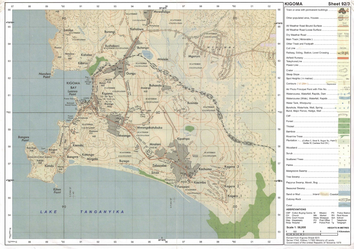 |
(a) Identity the features that found in the following grid references
- 923617
- 945599
- 910596
(b) Calculate the area of lake Tanganyika from 570 Southward. Give your answer in Km2
(c) What is the length of the railway line from grid reference 944633 Eastward. Give your answer in Km.
(d) With evidence suggest the type of settlement patterns depicted in the map.
(e) By providing evidences, explain three (3) human economic activities and two (2) social activities that might be taking place in the area.
4. The following table indicates scores of Geography weekly test for some form four students at Mwakalel Secondary School in 2021.
| Student's name | Mwantege | Mwaipya | Mwaitabete | Mwakatundu | Mwakabute |
| Sares | 70 | 50 | 70 | 80 | 40 |
(a) Present the data by means of divergence bar graph
(b) Give two merits and two demerits of the methods used.
5. (a) Mary is a good cartographer, she intends to produce a contoured map of Morogoro. What type of survey method would you advise her to apply.
(b) A part from producing contoured maps what is the other significance of the survey you have mentioned in (a) above.
(c) Mention and explain uses of any three instruments which are used in a method you mentioned in (a) above.
6. Kibwena is studying in a boarding school at Kigoma but his home is in Tarime District where he used to observe several conflicts between farmers and pastoralists. In his third week in school he heard through, the radio that, a farmer was killed by the pastoralist in his home village he decided to conduct research about the conflict.
(a) Suggest the statement of the problem for his research.
(b) Identify two sources of that research problem
(c) Elaborate four (4) possible research tools he could use during data collection,
(d) Explain three significance or conducting that research.
7. Carefully study the following photograph and answer the questions that follows:-
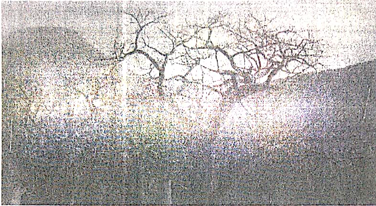 |
(a) By giving two reasons, identify the type of photograph
(b) With evidences, suggest two climates of the area
(c) Name the feature found at the background of the photograph.
(d) Give one reason, why the major trees shown in the photograph have no leaves?
(e) Why the images of trees at the fore ground seems to be large than those trees at the back ground even if are of the same size?
SECTION C (30 Marks)
Answer two (2) questions from this section.
8. Development of transport and communication system takes place fast where there is enough capital. But lack of capital leads to poor and slow development of transport and communication. Therefore the government should invest more capital to constructing good infrastructure because of the major importance that are found within this sector. Give six importance of transport and communication to any nation.
9. With examples describe cultural beliefs which influence high fertility or birthrate in developing countries lake Tanzania as your reference (provide six (6) points).
10. "Manufacturing industry plays a great role to the economic development of a country?' clarify any six (6) constrains which face the development of textile industry in Tanzania.
FORM FOUR GEOGRAPHY EXAM SERIES 99
FORM FOUR GEOGRAPHY EXAM SERIES 99
THE PRESIDENT’S OFFICE
MINISTRY OF EDUCATION, REGIONAL ADMINISTRATION AND LOCAL GOVERNMENT
COMPETENCE BASED SECONDARY EXAMINATION SERIES
GEOGRAPHY TERMINAL EXAMINATION
FORM FOUR -2022
INSTRUCTIONS
- This paper consists of sections A, B and C with a total of ten (10) questions.
- Answer all questions in sections A and B and any two (2) questions from section C.
- Map extract of Mkomazi (Sheet 109/1) is provided.
- Programmable calculators, cellular phones and unauthorised materials are not allowed in the examination room.
- Write your Examination Number on every page of your answer booklet(s).
SECTION A (15 Marks)
Answer all questions in this section.
1. For each of the items (i) — (x), choose the correct answer from among the given alternatives and write its letter besides the item number in the answer booklet provided.
(i)Due to the spinning effect of the earth, air currents do not travel in straight line. The term used to describe this situation is
- Deflection
- Reflection
- Deflaction
- Abrasion
- Direction
(ii)If the time at place X 45°E is 10:00am what will be the time at place Y 45°W?
- 6:00am
- 10:00am
- 4:00pm
- 4:00am
- 10:00pm
(iii)The temperature at place K whose altitude is 200metres is 20°C. What will be the temperature at mount H whose altitude is 3400metres?
- 39.2°C
- 0.8°C
- 19.2°C
- 10.8°C
- 21°C
(iv)When a river system is not related to the structure of the region where it flows, the system is said to show a drainage pattern known as
- Trellis
- Superimposed
- Rejuvenated
- Dendritic
- Normal
(v)Which of the following combined processes makes mass wasting?
- Soil creep
- Mud flow
- Granular disintegration
- Rock falls and landslides
- Joint and crack
(vi)Which of the following features are produced by water action on the desert?
- Yardangs and playas
- Sand-dunes and Canyons
- Alluvial fans and zeugens
- Canyons and playas
- Yardangs and sand-dunes
(vii)The rocks which contain iron are easily weathered through the process called
- Hydrolysis
- Hydration
- Oxidation
- Carbonation
- Solution
(viii)Soil with clear distinguishable horizons which occur in definite region of climate and vegetation are known as
- Intrazonal soil
- Clay soil
- Azonal soil
- Zonal soil
- Silt soil
(ix)Plants with long roots, thorny stems, needle-shaped leaves, wax or hair found in;
- Hot desert
- Mediterranean region
- Equatorial region
- Tropical grass lands
- Mountain region
(x)A good example of igneous rocks is
- Gneiss
- Basalt
- Gabbro
- Marble
- Slate
2. Match the items in LIST A with the responses in LIST B by writing the letter of the correct response beside the item number in your booklet provided.
| LIST A | LIST B |
|
|
SECTION B (55 MARKS)
Answer all questions in this section
3.Study the map extract of Kasamwa (sheet 32/4) then answer the questions that follow:
- By using the given R.F. Scale, measure the distance of all-weather road in Kilometers from grid 330851 to grid 430924
- Through giving evidence, explain any four (4) economic activities that might be taking place in the area
- Find the bearing of Bungwe Hill grid reference 430820 from Chabulongo Hill grid reference 365915
- Name the methods used to show the relief features on the map
- Name the main features found in the following grid reference
- 315850
- 430930
- 360860
- 360860
- 320915
4.Study the following data for vehicles moving along Morogoro-Dodoma, and then answer the following questions
| Period | Dustan | Land Rover | Isuzu | Toyota | Others |
| 8:30 – 10:30am | 100 | 150 | 300 | 240 | 80 |
| 2:30 – 4:30pm | 40 | 60 | 70 | 20 | 50 |
| 6:30 – 8:30pm | 120 | 130 | 90 | 140 | 120 |
| TOTAL | 260 | 340 | 460 | 400 | 250 |
- Present the data above by means of a Pie chart
- Describe the advantages and disadvantage of the method you have used in (a) above (2 points each case)
5(a)What is plane table survey?
(b)Mention the composition of the chain survey team and state the role of each member.
(c)Using diagram, demonstrate how to conduct chain survey in an area with a small hill which cannot be walked around easily
6(a)Point out five (5) objectives of doing research in Tanzania
(b)Explain the meaning the following concepts as applied in research
- Reconnaissance
- Questionnaires
- Data analysis
- Systematic sampling
- Hypothesis formulation
- Primary data
7.Carefuly study the photograph below and answer the questions that follows.
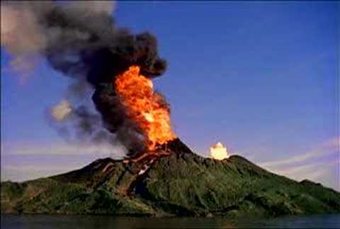
- With two (2) reasons suggest the type of photograph shown above?
- Name the natural activity taking place in the photograph
- Mention any three (3) extrusive features formed by the activity in 7(ii) above
- State any three (3) positive impacts and any three (3) negative impacts of the activity taking place in the photograph
SECTION C (30 MARKS)
Answer two (2) questions from this section
8.Population in Sub-Sahara Africa is unevenly distributed. Discuss (six points)
9. (a) Distinguish between large scale and small-scale farming. (Three points)
(b) What are the advantages of large-scale farming over small scale farming? (Three points)
10.The Earth spins on its own axis from West to East and make one complete rotation after 24 hours. What are the outcomes of this motion? (Four points)
FORM FOUR GEOGRAPHY EXAM SERIES 86
FORM FOUR GEOGRAPHY EXAM SERIES 86
THE PRESIDENT’S OFFICE
MINISTRY OF EDUCATION, REGIONAL ADMINISTRATION AND LOCAL GOVERNMENT
SECONDARY EXAMINATION SERIES
GEOGRAPHY TERMINAL EXAMINATION
FORM FOUR-2021
Time: 3Hours
Instructions.
- This paper consists of section A, B and C with a total of 10 questions
- Answer all questions in section A and B and two questions from section C.
- Section A carries 15 marks, section B 55 marks and section C 30 MARKS
- Map extract sheet for Kigoma (Series Y742 sheet 92/3), is provided.
- Programmable calculators, cellular phones and any other unauthorized materials are not allowed in examination room.
- Write your number on every page of your answer booklet.
SECTION A (15 Marks)
Answer All questions in this section.
1. For each of the items (i) - (x), choose the correct answer from among the given alternatives and write its letter beside the item number.
(i) Which one of the following, by origin and composition is not a form of igneous rocks?
- Sill
- Gypsum
- Lava plain
- Volcano
(ii) One of the following features is a product of weathering:
- Earth pillar
- Gully
- Lilly
- Hot springs
- Soil creep.
(iii) One of the following features is a product of weathering:
- Earth pillar
- Gully
- Lilly
- Hot springs
- Soil creep.
(iv) The following are instruments used in chain and tape survey:
- Barometer, pegs, notebook, compass
- Tape measure, chain, cross staff, anemometer
- Chain, arrows, ranging poles, altimeter
- Arrows, ranging poles, pegs, chain
- Cross staff, notebook, chain and plane table.
(v) When the river flows in its long profile it performs the following geological activities:
- Moves fast and can carry everything on the earth’s surface
- Erodes, transports and deposits weathered materials
- Meanders and forms ox-bow lakes throughout the profile
- Does three functions such as abrasion, solution and attrition
- Acts as agent of weathering and erosion along the profile.
(vi) If the location of a point on a map is given by grid reference 365490, then
- 365 are Degrees
- 365 are Longitudes
- 490 are Northings
- 490 are Eastings
- 365 are Northings
(vii) Which of the following is the effect of mass wasting?
- Frost action
- Interlocking spur
- Rock fall
- Exfoliation
- Rock disintegration.
(viii) The columns of clay capped by boulders formed due to rain action are known as:
- soil creep
- gullies
- land slide
- earth pillars
- cuesta
(ix) A time accepted throughout a time zone of 15° longitude is known as
- local time
- noon time
- greenwich mean time
- sun time
- standard time.
(x) Which sequence of the following processes is necessary for the formation of rainfall?
- Condensation, cooling and evaporation
- Evaporation, cooling and condensation
- Evaporation, sedimentation and cooling
- Evaporation, condensation and cooling
- Evaporation, cooling and sedimentation.
2. Match the descriptions of karst region features in Column A with the corresponding feature in Column B by writing the letter of the correct answer beside the item number in the answer booklet provided.
| Column A | Column B |
|
|
SECTION B (55 Marks)
Answer all questions in this section.
3. Study the printed map extract of Kigoma (Series Y742 sheet 92/3), then answer the following questions:
(a) By using the vertical scale of 1cm to 20m, draw a cross section from grid reference 91057 to grid reference 932620 and determine its Vertical Exaggeration (V.E).
(b) With vivid evidence from the map, mention the major types of transport shown in the area.
(c) Apart from fishing activities, use concrete evidence to name other economic activities taking place in the area.
(d) In which hemisphere is the mapped area located? Give evidence for your answer.
4. (a) Using examples from East Africa, describe each of the following types of volcanoes:
(i) Active Volcano
(ii) Dormant Volcano
(b) Using a well labelled diagram, explain how each of the following features were formed:
(i) Composite Volcano
(ii) Volcanic plug.
(c) Explain four negative effects of vulcanization
5. Carefully study the hypothetical data presented below showing the export of crops from Tanzania.
The Export of Crops in Tonnes
| Year | Cloves | Sisal | Cotton |
| 1990 | 4000 | 3500 | 7000 |
| 1991 | 2500 | 2000 | 4500 |
| 1992 | 3500 | 1500 | 6000 |
| 1993 | 6000 | 1000 | 8500 |
| 1994 | 6500 | 1500 | 9000 |
(a) Present the data using compound bar graph.
(b) Explain two advantages and disadvantages of compound bar graph.
5. (a) What is a research problem?
(b) Name four sources of research problem.
(c) Explain four characteristics of research problem.
3. (a) The diagram below represents some volcanic features. Use it to answer the questions below.
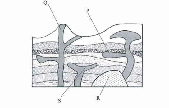
Name the features marked P, Q, R and S.
P— Sill (1 mark) Q — Vent
R — Batholith
S— Lopolith
(b) Identify the main characteristics of the ocean water.
(c) Give three factors that influence wave deposition.
SECTION C (30 Marks)
Answer two (2) questions from this section.
8. Analyse eight problems associated with growth of urban settlement.
9. Describe six contributions of cash crops production of the economy of United States of America.
10. Explain eight characteristics of shifting cultivation.
FORM FOUR GEOGRAPHY EXAM SERIES 51
FORM FOUR GEOGRAPHY EXAM SERIES 51
THE PRESIDENT’S OFFICE MINISTRY OF EDUCATION, LOCAL ADMINISTRATION AND LOCAL GOVERNMENT
GEOGRAPHY- TERMINAL- EXAMINATION-MAY
FORM FOUR
Time 3:00 Hours MAY 2020
Instructions
- This paper consists of sections A, B, and C.
- Answer all questions in sections A, and B two questions from section C.
- Map extract of Arusha (Sheet 55/3) is provided.
- Credit will be given for the use of relevant diagrams.
- Calculators and Cellular phones are not allowed in the examination room.
- Write your Examination Number on every page of your answer booklet(s)
SECTION A. 15 MARKS
1. For each of the items (i) (x), choose the correct answer from among the given alternatives and write its letter besides the item number in the answer booklet provided.
(i) Which of the following instrument is used to measure maximum and minimum temperature?
- Barometer
- Thermometer
- Anemometer
- Six's thermometer
- Hydrometer.
(ii) Which among the following is an extrusive volcanic feature?
- Crater
- Laccolith
- Batholith
- Sills
- Dykes.
(iii) Prediction of the state of atmosphere in a region for 24 to 48 hours is known as
- weather elements
- weather report
- weather instrument
- weather station
- weather forecasting
(iv) Which of the following is another name for Savanna climate in Africa
- Tropical maritime.
- Warm temperature maritime.
- Tropical grassland.
- Warm temperature desert.
- Cool temperate western margin.
(v) Day reaches its maximum length on 21st June in
- Southern hemisphere
- Northern Hemisphere
- Arctic Circle
- Polar region
- Tropic of Capricorn.
(vi) The excessive strong wind blowing across an extensive ocean surface is called
- Tsunami
- Ocean
- Storm surge
- Hurricane
- Wind
(vii) Which of the following is not a factor influencing temperature of a place?
- Aspect
- Ocean current
- Altitude
- Eclipse
- Length of a day
(viii) Which one of the following conditions is important for the growth of coral reefs?
- Warm and muddy river water
- Warm and muddy sea water
- Warm and clear sea water
- Warm and clear tape water
- Warm and clear river water.
(ix) A cirque is
- an arm-chair shaped depression on a glaciated lowland area
- an arm-chair shaped depression on the sides of a glaciated mountain
- an arm-chair shaped depression in the desert areas
- an arm-chair shaped valley in glaciated areas
- an arm-chair shaped depression on the plateau.
(x) A channel diverging from the main river and flowing into the sea or a lake by a separate mouth is called
- tributary
- stream
- distributary
- river basin
- water shade
2. Match the items in List A with the responses in List B by writing the letter of the correct response besides the item number in the answer booklet provided.
| LIST A | LIST B |
|
|
SECTION B. 55 MARKS
3. Carefully study the following statistical graph showing coffee production (in tonnes) in Tanzania, from 2011 to 2014 and answer the questions that follows

(a) Describe the type of statistical graph used.
(b) Analyse the five procedures involved in constructing such a statistical graph.
(c) Giving two points, comment on the differences in coffee production shown in the graph.
(d) Give three advantages of presenting data by using the type of graph described in 3(a).
4. (a) Describe the following research terms:
- Population.
- Random sampling.
- Literature review.
(b) (i) Define secondary data.
(ii) Give four merits of secondary data.
5. Carefully study the map extract of Arusha (Sheet 55/3) provided then answers the questions that follow.
(a) Describe the relief of the mapped area.
(b) Giving evidences, mention the major means of transport shown in a map.
(c) Change the scale of the map into a statement scale.
(d) Measure the length of the road from grid reference 378314 to grid reference 480276 in kilometres.
(e) With evidence from the map, identify three social services which are found in this area.
6. Study the photograph provided below and then answer the questions that follows:

(a) Name the type of photograph.
(b) Give three characteristics of the type of photograph in (a) above.
(c) Explain four possible factors which may cause the loss of biodiversity in the photograph.
(d) Give two economic importance of the area.
(e) In three points, describe the importance of the vegetation shown in the area.
7. (a) Explain the meaning of the standard deviation.
(b) Study the following data showing the age of the Primary School pupils at Tumaini Primary School and answer the questions that follow: 15, 8, 7, 6, 12, 5, 14 and 13.
(i) Determine the range and median of the age of the pupils.
(ii) Calculate the standard deviation.
SECTION C. 30 MARKS.
Answer two questions from this section.
8. Describe five uses of population data to a country.
9. Explain six problems associated with expansion of cities in Tanzania.
10. Describe seven problems associated with rapid urbanization.
11. Examine seven effects of climatic change in the world.
FORM FOUR GEOGRAPHY EXAM SERIES 16
FORM FOUR GEOGRAPHY EXAM SERIES 16

DOWNLOAD LEARNING HUB APP NOW

SORRY, YOU CAN'T VIEW THIS MARKING SCHEME PLEASE DOWNLOAD LEARNING HUB APP FROM PLAYSTORE TO GET FULL ACCESS TO ALL MARKING SCHEME!!
Click Here To Download Learning Hub Tanzania App
SAMAHANI, HUWEZI KUFUNGUA MAJIBU YA MTIHANI, TAFADHALI PAKUA APP YA LEARNING HUB TANZANIA ILI KUWEZA KUFUNGUA MAJIBU YA MITIHANI KATIKA TOVUTI HII!!
Bofya Hapa Kupakua App Ya Learning Hub Tanzania
Hub App
 For Call,Sms&WhatsApp: 255769929722 / 255754805256
For Call,Sms&WhatsApp: 255769929722 / 255754805256  MATOKEO KIDATO CHA IV 2023
FORM ONE SELECTION 2024
Matokeo Darasa VII 2023
SECONDARY REGIONAL EXAMS
PRIMARY REGIONAL EXAMS
FORM VI NECTA REVIEWS
FORM IV NECTA REVIEWS
FORM II NECTA REVIEWS
STD VII NECTA REVIEWS
STD IV NECTA REVIEWS
SECONDARY EXAMS SERIES
PRIMARY EXAMS SERIES
PRIMARY SUBJECT NOTES
SECONDARY SUBJECT NOTES
SECONDARY TOPICAL EXAMS
SECONDARY TOPICAL QUESTIONS
PRIMARY TOPICAL QUESTIONS
PRACTICAL EXAMS & NOTES
SECONDARY REGIONAL EXAMS
DOWNLOAD SUBJECT NOTES
SCHEMES OF WORK (PRIMARY & SECONDARY)
LESSON PLAN
SECONDARY LOG BOOKS
PRIMARY LOG BOOKS
LITERARY WORKS / UCHAMBUZI VITABU
METHALI ZOTE ZA KISWAHILI
Vitendawili Vya Kiswahili
FORM VI RESULTS 2023
FORM FIVE SELECTION 2023
Matokeo KIDATO CHA II 2022
Matokeo Darasa IV 2022
MATOKEO KIDATO CHA IV 2023
FORM ONE SELECTION 2024
Matokeo Darasa VII 2023
SECONDARY REGIONAL EXAMS
PRIMARY REGIONAL EXAMS
FORM VI NECTA REVIEWS
FORM IV NECTA REVIEWS
FORM II NECTA REVIEWS
STD VII NECTA REVIEWS
STD IV NECTA REVIEWS
SECONDARY EXAMS SERIES
PRIMARY EXAMS SERIES
PRIMARY SUBJECT NOTES
SECONDARY SUBJECT NOTES
SECONDARY TOPICAL EXAMS
SECONDARY TOPICAL QUESTIONS
PRIMARY TOPICAL QUESTIONS
PRACTICAL EXAMS & NOTES
SECONDARY REGIONAL EXAMS
DOWNLOAD SUBJECT NOTES
SCHEMES OF WORK (PRIMARY & SECONDARY)
LESSON PLAN
SECONDARY LOG BOOKS
PRIMARY LOG BOOKS
LITERARY WORKS / UCHAMBUZI VITABU
METHALI ZOTE ZA KISWAHILI
Vitendawili Vya Kiswahili
FORM VI RESULTS 2023
FORM FIVE SELECTION 2023
Matokeo KIDATO CHA II 2022
Matokeo Darasa IV 2022


