Student Assessment Number…………………………
PRESIDENT OFFICE REGIONAL ADMINISTRATION
AND LOCAL GOVERNMENT
SECONDARY EXAMINATION SERIES
COMPETENCE BASED ASSESSMENT
GEOGRAPHY FORM TWO
MID TERM EXAMS- 2023
013
Time 2.30 Hours AUG, 2023
INSTRUCTIONS
- This paper consists of section A,B and C with a total of ten (10) questions.
- Answer all questions
- Section A and C carry fifteen (15) marks each and section B caries seventy (70) marks
- All writings must be written in the space provided.
- Any unauthorized materials are not allowed in the assessment room
- Write your assessment number at the top right corner of every page.
SECTION A (15 MARKS)
Answer all questions
1. For each of the items (i) – (x), choose the correct answer from the given alternatives and write it’s letter in the box provided.
- In a group discussion, Mero told his fellow form two students that “ocean floor consists of numerous features”. Which one of the following groups of terms do you think mentioned by Mero as applicable to some parts of the ocean floor?
- Basin, deep, cirque, plateau
- Ocean ridge, ocean deep, deep sea plain, continental slope
- Sea trench, beach, basin, ridge
- Sea ridge, ocean deep, ocean basin, water falls
- The earth is constantly rotates and revolves while inclined on it’s axis. What does a permanent tilt of the earth axis and revolution of the earth in it’s orbit cause?
- Day and Night
- The deflection of winds
- Difference in time between places on different meridians
- Varying length of day and night at different times of the year
- Ms Kweka visited all tropical climatic regions. In her visits she observed great temperature variations among the regions. Which of the following tropical climate does Ms Kweka observed to have the largest diurnal temperature range?
- Equatorial climate
- Tropical monsoon
- Tropical savanna
- Hot desert
- The students of Nguvu Moja Secondary school visited the farmers at Mivinjeni village, at the village they observed the farmer cultivating using machines like tractors, what kind of agriculture was practiced by the farmer at Mivinjeni village?
- Bush fallowing
- Large scale agriculture
- Nomadic cultivation
- Small scale agriculture
- When the noon sun is directly overhead at the tropic of cancer (23.50N latitude) around 21 June in the northern hemisphere, the condition known as:
- Summer Solstice
- Spring Solstice
- Winter Solstice
- Autumn Solstice
- The temperature at Korogwe 950m is 24
 . What is the temperature of Kilimanjaro 5895m above the sea level?
- 5.670C
- 18.150C
- -5.670C
- 10.240C
- Suppose a meteorologist measured the temperature at Antananarivo 770F and convert it into degrees centigrade as 250 C. Which among the following formula a meteorologist used to convert from 0F to 0C?
- 0F = 9/5 (0C + 32)
- 0C = 9/5 (0F – 32)
- 0F = 5/9 ( 0C + 32)
- 0C = 5/9 (0F -32)
- A person may either gains or losses time when travels across international date line east or west respectively .Hence one gains in terms of time by 60 minutes for every 150 of longitude when travels from:
- North to South
- East to South
- West to East
- East to West
- There are so many imaginary lines drawn to explain the earth’s surface, some are vertical, horizontal and inclined. Which of the following statements best describes longitude?
- An imaginary line on the earth’s surface joining the north and south poles
- The angular distance east or west of the Greenwich meridian
- The distance of a place east or west of the Greenwich meridian
- The position of a place on the earth’s surface with reference of the prime meridian
- The tourists from Germany to Tanzania were interested to visit mountains formed by cooling and solidification of molten material. Which type of mountains will satisfy their interest?
- Residual Mountains.
- Block mountains
- Fold Mountains
- Volcanic mountains
2. Match the items in LIST A with the corresponding one in LIST B by writing the letter of the
correct response below the item number in the table provided.
| LIST A | LIST B |
|
|
| LIST A | i | ii | iii | iv | v |
| LIST B |
|
|
|
|
|
SECTION B (70marks)
Answer all questions
3. Dr .Katigile measured a bearing of Dodoma (NW) from Dar-es-salaam (SE) in Tanzania and read 3050NW of Tanzania at 11: 30 am
a) Out line four procedures used by Dr. Katigile to measure the bearing
i. ………………………………………………………………………………………………
ii. ………………………………………………………………………………………………
iii………………………………………………………………………………………………
iv. ………………………………………………………………………………………………
b) Name the type of bearing measured by Mr. Katigile
………………………………………………………………………………………
c) Show other possible ways that can be used to locate the position of a place
- ………………………………………………………………………………………………
- ………………………………………………………………………………………………
- ………………………………………………………………………………………………
- ………………………………………………………………………………………………
4. James family was watching TV at home; the program was a weather forecasting. James and his wife got angry with the program as they said weather forecasting is useless to them.
a) As a F II geography student helps James family to understand the importance of weather forecasting (Four points)
- ………………………………………………………………………………………………
- ………………………………………………………………………………………………
- ………………………………………………………………………………………………
- ……………………………………………………………………………………………
b) List at least two dangerous that a country will face when weather forecasting is not implemented
- ………………………………………………………………………………………………………………………………………………………………………………………………
- ………………………………………………………………………………………………………………………………………………………………………………………………
5 a) Draw a well labeled diagram to show the solar eclipse

b) Briefly describe on how the sun eclipse you have drawn above occurs
………………………………………………………………………………………………………
………………………………………………………………………………………………………
………………………………………………………………………………………………………
c) Give two impacts which may occur due to solar eclipse
- ………………………………………………………………………………………………………………………………………………………………………………………………
- ………………………………………………………………………………………………………………………………………………………………………………………………
6. A teacher at Ilulu Secondary School gave an assignment to FII students on identifying various energy resources both renewable and non – renewable energy resources. As one among Form II students
a) Mention any five (5) energy resources in the world.
- ………………………………………………………………………………………………
- ………………………………………………………………………………………………
- ………………………………………………………………………………………………
- ………………………………………………………………………………………………
- ………………………………………………………………………………………………
b) Give three (3) importance of renewable energy resources
- ………………………………………………………………………………………………………………………………………………………………………………………………
- ………………………………………………………………………………………………………………………………………………………………………………………………
- ………………………………………………………………………………………………………………………………………………………………………………………………
c) What are the two challenges facing the production and uses of non – renewable resources
- ………………………………………………………………………………………………
- ………………………………………………………………………………………………
7. In making a good map, scale is very important information to be considered. Without a scale map isincomplete:
a) With examples, outline three types of map scale
- ………………………………………………………………………………………………
- ………………………………………………………………………………………………
- ………………………………………………………………………………………………
b) In which ways the map scale can be expressed
- ………………………………………………………………………………………………
- ………………………………………………………………………………………………
- ………………………………………………………………………………………………
c) Give two importance of a map scale
- ................................................................................................................................................
- ………………………………………………………………………………………………
d) Suppose that one centimeter on the map represent a half Kilometer on the ground (1cm to ½ km), covert it into representative Fraction scale
………………………………………………………………………………………………………
………………………………………………………………………………………………………
………………………………………………………………………………………………………
………………………………………………………………………………………………………
………………………………………………………………………………………………………………………………………………………………………………………………………………………………………………………………………………………………………………………………………………………………………………………………………………………………………………………………………………………………………………………………………………………………………………………………………………………………………………………………………………………………………………………………………………………
8. A meteorologist gave the Form two students books to discuss about five climatic regions, In their reading and discussion they noted one among the five regions is located along 00 to 50 North and south of the equator.
a) What type of climatic region do the students noted being located from 00 to 50?
………………………………………………………………………………………………………
b) Where does the climatic region mentioned in (a) above distributed in the world?
………………………………………………………………………………………………………
……………………………………………………………………………………………………
………………………………………………………………………………………………………
c) Mention five climatic characteristics of the region mentioned in (a) above.
- ………………………………………………………………………………………………
- ………………………………………………………………………………………………
- ………………………………………………………………………………………………
- ………………………………………………………………………………………………
- ………………………………………………………………………………………………
d) What are the four dominant economic activities that are practiced in the climatic region mentioned (a) above
- ………………………………………………………………………………………………
- ………………………………………………………………………………………………
- ………………………………………………………………………………………………
- ………………………………………………………………………………………………
9. Mr Brown is an American investor, he just came from U.S.A and want to set up manufacturing industry in your country. He is now stress full since he don’t know where and how he will manage to establish industry. As a geographer
a) Out line five factors to assist Mr Brown to locate manufacturing industry in your country
- ………………………………………………………………………………………………
- ………………………………………………………………………………………………
- ………………………………………………………………………………………………
- ………………………………………………………………………………………………
- ………………………………………………………………………………………………
b) Give three (3) importance of manufacturing industry in the country
- ………………………………………………………………………………………………
- ………………………………………………………………………………………………
- ………………………………………………………………………………………………
c) List down two main challenges that hinder the development of manufacturing Industry
- ………………………………………………………………………………………………
- ………………………………………………………………………………………………
SECTION C (15marks)
Answer question ten (10)
10. “DAWASCO was the responsible medium for water supply and management in Dar-es –salaam. The sector helped the government acknowledging people on the importance and need for water management. Some people failed to understand. As an expert in the whole aspect of water, describe significances of water management for daily life
………………………………………………………………………………………………………………………………………………………………………………………………………………………………………………………………………………………………………………………………………………………………………………………………………………………………………………………………………………………………………………………………………………………………………………………………………………………………………………………………………………………………………………………………………………………………………………………………………………………………………………………………………………………………………………………………………………………………………………………………………………………………………………………………………………………………………………………………………………………………………………………………………………………………………………………………………………………………………………………………………………………………………………………………………………………………………………………………………………………………………………………………………………………………………………………………………………………………………………………………………………………………………………………………………………………………………………………………………………………………………………………………………………………………………………………………………………………………………………………………………………………………………………………………………………………………………………………………………………………………………………………………………………………………………………………………………………………………………………………………………………………………………………………………………………………………………………………………………………………………………………………………………………………………………………………………………………………………………………………………………………………………………………………………………………………………………………………………………………………………………………………………………………………………………………………………………………………………………………………………………………………………………………………………………………………………………………………………………………………………………………………………………………………………………………………………………………………………………………………………………………………………………………………………………………………………………………………………………………………………………………………………………………………………………………………………………………………………………………………………………………………………………………………………………………………………………………………………………………………………………………………………………………………………………………………………………………………………………………………………………………………………………………………………………………………………………………………………………………………………………………………………………………………………………………………………………………………………………………………………………………………………………………………………………………………………………………………………………………………………………………………………………………………………………………………………………………………………………………………………………………………………………………………………………………………………………………………………………………………………………………………………………………………………………………………………………………………………………………………………………………………………………………………………………………………
FORM TWO GEOGRAPHY EXAM SERIES 157
FORM TWO GEOGRAPHY EXAM SERIES 157
Student's Assessment
THE PRESIDENT’S OFFICE
REGIONAL ADMINISTRATIVE AND LOCAL GOVERNMENT
FORM TWO EXAMINATIONS SEPTEMBER 2022
NEW NECTA FORMAT
GEOGRAPHY
TIME: 2:30 Hours
![]()
Instructions
- This paper consists of section A, B and C with a total often (10) questions.
- Answer all questions in section A and B and section C.
- All writing must be in blue of black ink.
- All answers must be written in the space provided.
- Cellular phones, calculator and any unauthorized materials are not allowed in the examination room.
- Write your examination number at the top right corner of every page.
SECTION A (15 MARKS)
Answer all questions in this section.
1. For each of the items (i) — (x), choose the correct answer from among the given alternative and write its letter in the box provided.
i.When the spring equinox does occurs?
- 3 rdJanuary
- 23 rdSeptember
- 21 st march
- 4th July ii.
- The stretch of land where standard time is accepted throughout a longitudinal zone 15 0 in width.
- Time zone
- Greenwich mean time
- Standard time
- Prime meridian time
- Deflection of wind and daily rising and falling of tides are among the
effects of?
A. Earth's movement B. Earth's rotation
- Earth's revolution
- Aphelion and perihelion
iv. Ocean water occupies about …... . Percent of the earth's surface,
A. 21
B. 29
C. 71
D .70
- The streams that join together to form main streams.
- Distributaries
- Drainage
- Tributaries
- River basin
- If the temperature at dare s salaam which is at sea level is 320c, what will be the temperature at a place where altitude is 1,500meters?
- 0.60c
- 230c
- 90c
- D. 41 0c
- Dormant volcanic mountains are those which
A. Have never experienced eruptions.
- Have erupted once but are no longer active
- Continue to erupt occasionally
- Erupt when there is an earth quake
- The region which found between 50 and 200 North and South of Equator
- Savanna grassland
- Equatorial region
- The hot deserts
- Mediterranean climate
- If the temperature of station X is 1040F, What is the temperature of the same station in 0C.
- 420C
- 360C
- 21 0C
- 400C
(x) Isohyets are the lines on a map which join all places with the same
- Height above the sea level
- Amount of rainfall
- Atmospheric pressure
- . Natural vegetation
- Match the items in List A with responses in List B by writing the letter of the correct response below the corresponding item number in the table provided.
| List Å | List B | ||||||
| i. Rocks which allows water to pass through ii. Water which originates from precipitation such as snowfall iii. Water from greater depths of earth's surface as a result of volcanic activity iv. The rocks which have pores through which water can filtrate v. Salt extraction, fishing, sand, seaweeds and decorative items such as corals and sea shells |
| ||||||
| List A | 1 | 11 | 111 | iv | v | ||
| List B | |||||||
SECTION B (70marks)
Answer all questions in this section
- In each of the following items (i-x ), write TRUE if the statement is correct or FALSE if the statement is not correct.
- The moon takes 31 days to make a complete revolution round the earth.
- The generation and distribution of electric power in Tanzania is done by DAWASCO.
- Isokinetic is the lines on the map joining places with the same wind movements..
- Altitude, latitude and ocean current are the factors that affect temperature..
- Topographical maps used to express descriptive information such as pressure, temperature and crops..
- The differences between weather and climate based on time and area covered..
- Always stream channel carries more water in Morogoro region during the dry seasons
- The planets are called wandering stars in Greek………………..
- Coal, petroleum, oil, natural gas and wind are examples of nonrenewable resources...
- Pipelines transport is suitable for carrying water, petroleum and gas.
- (a) List down five techniques used in land reclamation
(b) Briefly explain three major types of rainfall
(c) Give out four sources of water pollution.
(d)Naturally we believe that the earth rotates on its axis from west to east in an anticlockwise direction through 3600 with examples describe the evidences that prove that the earth rotates from west to east. Give three points.
5. (a) Define the term climate change.
(b) Give three human causes of climate change
(c) Briefly describe the impacts of climate change to physical and human environment. Give five
7. (a) What are the values of scale to the map users? Gives three
- Which methods can be used to locate position of a place on the map? Mention four.
- The distance of the road from Ifakara to Mang’ula is 38 cm. convert the distance in kilometer if the scale used is 1:50000.
- Why do you study maps? Give two reasons
- A large scale, medium scale and small scale maps all are the types of map scale.
With examples explain how they are distinguished by one to another. Give two reasons.
8. The Form Two students 'Were very happy to visit a place where a process of extracting valuable geological substance from the crust was taking place.
(a) How is the process taking place in the area called?
(b) List three possible types of valuable geological substance found in the area.
(c) Describe three main methods of extracting those valuable geological substances in the area.
(d) Outline five possible environmental hazards caused by the process taking place in the area
9. Elaborate five differences between heavy industries and light industries.
SECTION C (15 Marks)
10. Describe six consequences of water shortage to the communities.
FORM TWO GEOGRAPHY EXAM SERIES 117
FORM TWO GEOGRAPHY EXAM SERIES 117
THE PRESIDENT’S OFFICE
MINISTRY OF EDUCATION, REGIONAL ADMINISTRATION AND LOCAL GOVERNMENT
SECONDARY EXAMINATION SERIES
GEOGRAPHY MID TERM EXAMINATION
FORM TWO-AUG/SEPT-2021
Time: 2:30Hours
Instructions.
- This paper consists of section A, B and C with a total of 10 questions
- Answer all questions in section A and B and TWO questions from section C.
- Section A carries 25 marks, section B 45 marks and section C 30 Marks
- All answers should be written in the spaces provided.
- All communication devices, calculators and any unauthorized material are not allowed in examination room.
- Write your number on every page of your answer booklet.
SECTION A (35 Marks)
Answer All questions in this section.
- For each of the items (i)-(x), choose the correct answer from the alternatives given.
(i)The planet which is known to support life is the:
- sun
- moon
- earth
- mercury
(ii)The grid reference of station X is 261582. What are the numbers of the Eastings and the Northings?
- 583 are Eastings and 261 are Northings
- 158 are Eastings and 262 are Northings
- 582 are Northings and 261 are Eastings
- 651 are Northings and 582 are Eastings
(iii)The structure of the earth is composed of:
- carbon and sodium
- crust, mantle and core
- silicon and alumina
- sima and sial
(iv)Which of the following tropical climates has the largest diurnal temperature range?
- Tropical monsoon
- Hot deserts
- Mediterranean
- Cold deserts
(v)A representative scale of can be represented by a statement scale of:
- 0.5 to 2.5 km
- 2cm to 25 km
- one cm to 2.5 km
- One cm to 250,000 cm
(vi)The time when the sun is overhead on latitude 23½0S or 3½0N is called:
- Solstice
- Aphelion
- Equinox
- Tropic of Cancer
(vii)Wind blows from:
- highlands to lowlands
- lowlands to highlands
- low pressure areas to high pressure areas
- high pressure areas to low pressure areas
(viii) The relative humidity of a region is low when:
- The wet and dry bulb thermometers read the same
- The difference between the readings of wet and dry bulb thermometers is large
- The temperatures are high
- The temperatures are low
(ix) Metallurgical industries deal with:
- machinery
- jewellery
- textile
- food products
(x) Hot deserts are characterized by:
- small range of temperature
- two peaks of annual rainfall
- large range of temperature
- high temperature during the day and night.
2. Match the items in List A with responses in List B by writing the letter of the correct response below the number of corresponding item in the table provided.
| LIST A | LIST B |
|
|
3.Write TRUE if the statement is correct or FALSE if the statement is not correct against each of the following statements.
(i)Agulhas is a good example of a warm current. .......
(ii)Pests and diseases are not common problems facing the farmers in Tanzania. .........
(iii)The Earth rotates from East to West......
(iv)Transportation involves the movement of goods, people and services from one place to another. .........
(v)The energy produced due to the movement of water is biogas. .........
(vi)A key acts as a dictionary of a map. .........
(vii)Salinity ofthe ocean water varies from place to place due to the different rates of evaporation. .........
(viii)Seasons are the result of earth rotation. .........
(ix)All latitudes are great circles. .........
(x)The main crop produced in Gezira irrigation scheme in Sudan is cotton.......
SECTION B (45 Marks)
Answer all questions in this section.
4.(a) Outline five importance of human activities
(b) Mention the characteristics of small scale Agriculture
5. (a) Define the following terms as used in Geography:
(i)Agriculture
(ii)Topographical map
(b) List two conditions necessary for establishing Hydro-Electric Power.
6. Explain the achievements that were brought by the Tennessee Valley Authority in North America.
SECTION C (30 Marks)
Answer two (2) questions from this section.
7. (a) Carefully study the climatic data given for station X and then answer the questions that follow:
| Month | J | F | M | A | M | J | J | A | S | O | N | D |
| Temp °C | 30 | 30 | 30 | 31 | 32 | 38 | 37 | 37 | 35 | 34 | 31 | 30 |
| RAINFALL (mm) | 10 | 20 | 26 | 15 | 8 | 0 | 0 | 0 | 12 | 18 | 15 | 10 |
(i) Calculate the annual range of temperature.
(ii) Determine the annual rainfall.
(iii) Calculate the mean annual temperature.
(iv) What type of climate does station X experience? Give reasons.
(v) Suggest the hemisphere in which station X is located.
(b)Study carefully the map provided below, then answer the questions that follow.
8.Describe five problems facing transportation industry in East Africa
9. Explain five problems that are facing the Rufiji basin project in Tanzania.
10. Explain how forests are endangered in Tanzania and suggest measures that can save them.
|
|
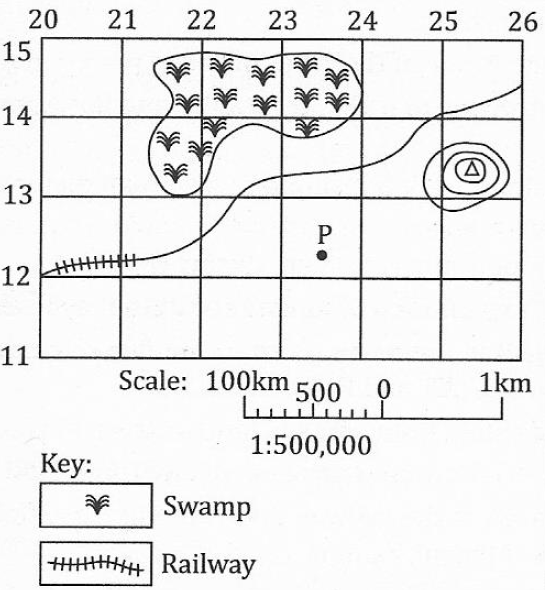
(i)List twoways used by this map to express the scale.
(ii)Give the indicators from the map which shows lowland and highland.
(iii)Why is the railway line not straight from grid reference 260144 to 200144?
(iv)Measure the length of the railway line from grid reference 260144 to 200120.
(v)Calculate the area covered by the swamp. Give your answer in square kilometres.
FORM TWO GEOGRAPHY EXAM SERIES 67
FORM TWO GEOGRAPHY EXAM SERIES 67
THE PRESIDENT'S OFFICE
MINISTRY OF REGIONAL GOVERNMENT AND LOCAL GOVERNMENT
AUGUST-SEPTEMBER EXAMINATION SERIES
GEOGRAPHY FORM-2
2020
TIME: 2:30 HRS
INSTRUCTIONS.
- This paper consists of sections A, B and C with a total of ten (10) questions.
- Answer all questions in section A and B and two (2) questions from section C
- All writing must be in blue or black ink.
- All answers must be written in the space provided.
- Calculators, cellular phones and any unauthorized materials are not allowed in the examination room.
- Write your Examination Number at the top right corner of every page.
SECTION A (25 Marks)
Answer all questions in this section.
1. For each of the items (i) – (ii), choose the correct answer from among the given alternatives and write its letter in the box provided.
(i) One characteristics of equatorial climate is:-
- Low rainfall
- Moderate temperature
- Low humidity
- Thick forest.
(ii) The direction to which compass needle points is called
- Magnetic north
- True north
- Grid north
- Compass bearing
(iii) Cultivation of cash crops based on application of advanced technology is called?
- Subsistence agriculture
- A large scale agriculture
- Mixed system agriculture
- A small scale agriculture
(iv) The condition of the atmosphere recorded for a short period of time is known as
- Climate
- Rainfall
- Weather
- Temperature
(v)Which type of climate among the following is different from the other?
- Mediterranean
- Savanna
- Hot desert
- Equatorial
(vi)Which scale is the largest among the following?
- 1:25,000
- 1:1,500,000
- 1:50,000
- 1: 10,000
(vii)Which one of the following features are correct set of the ocean floor?
- Ridge, basin, plateau and waterfall.
- Continental shelf, basin and waterfall.
- Trench, continental shelf and continental slope.
- Horst, plain and volcano.
(viii)A ship moves to the west and crosses the International Date Line. What happens in regard to time gained or lost?
- No time is gained or lost
- One whole days is lost
- One whole day is gained
- One whole day is repeated
(ix) Hot deserts are characterised by:
- small range of temperature
- two peaks of annual rainfall
- large range of temperature
- high temperature during the day and night.
(x) The land of East Africa is mainly characterized by:
- low lands valley
- highlands plateau and lowlands basin
- volcanic mountains and residue mountains
- highlands and fold mountains.
2.Match the items in List A with responses in List B by writing the letter of the correct response below the corresponding item number in the table provided.
| LIST A | LIST B |
|
|
3. Write True if the statement is correct or False if the statement is not correct in the space provided.
(i)Trans - Saharan Trade involved the exchange of goods between people of Northern and Eastern Africa ......
(ii)The development of Long Distance Trade in East Africa had a direct connection with the rise of Triangular Trade . ......
(iii)The Christian missionaries were against the abolition of slave trade.......
(iv)Industrial capitalism was characterized by open competition for markets and raw materials ...............
(v)The East African coast was known to Greeks and Romans as Azania ......
(vi) The most obvious result of the Mfecane was the depopulation of larger parts of southern Africa.....
(vii)Man learnt to keep animals during Early Stone Age . .......
(viii)The coming of Ngoni in East Africa led to shift from the small scale Ntemi system to weaker states ...............
(ix)The discovery of diamond turned South Africa from poor agricultural society to relatively rich industrial one ...............
(x)Written records refer to the study of our past as revealed by what has been handed down by word of mouth from one generation to another.
SECTION B (45 Marks)
Answer all questions in this section.
4.(a) Mention five features of the ocean floor.
(b) Name the five largest oceans in the world.
(c) Mention five largest lakes in the world.
(d) Differentiate the following terms:
(i)Temperature and humidity
(ii)Minimum and maximum thermometer
(iii) Pressure and wind
5. (a) Distinguish the following terms:
- Solar system and solar energy
- Raw materials and manufacturing industries
- Map and scale of a map
- Plateau and mountain
(b)
- Define lunar eclipse.
- Draw a well labelled diagram to show lunar eclipse.
6. Explain five measures which can be taken to ensure the sustainability of forests in Tanzania.
SECTION C (30 Marks)
Answer two (2) questions from this section.
7. Study the following climatic table and answer the questions that follow.
Station Y
| Months | Jan | Feb | March | Apr | May | June | July | Aug | Sep | Oct | Nov | Dec |
| Temp(0 C) | 22.5 | 25 | 25 | 25.5 | 25.5 | 25.5 | 25.5 | 25.5 | 26.1 | 26.1 | 26.1 | 26.6 |
| Rainfall(mm) | 198 | 340 | 431 | 350 | 280 | 230 | 160 | 71 | 15 | 12 | 15 | 66 |
- Suggest the type of climate of station Y.
- Calculate the daily mean temperature.
- Find the mean annual temperature.
- Find the annual rainfall for station Y.
- Mention any four crops that can be grown in station Y.
8. Describe five advantages of natural gas production in Tanzania
9. Describe six characteristics of small scale agriculture.
10.Using examples, explain five problems facing livestock farming in Africa.
FORM TWO GEOGRAPHY EXAM SERIES 33
FORM TWO GEOGRAPHY EXAM SERIES 33

DOWNLOAD LEARNING HUB APP NOW

SORRY, YOU CAN'T VIEW THIS MARKING SCHEME PLEASE DOWNLOAD LEARNING HUB APP FROM PLAYSTORE TO GET FULL ACCESS TO ALL MARKING SCHEME!!
Click Here To Download Learning Hub Tanzania App
SAMAHANI, HUWEZI KUFUNGUA MAJIBU YA MTIHANI, TAFADHALI PAKUA APP YA LEARNING HUB TANZANIA ILI KUWEZA KUFUNGUA MAJIBU YA MITIHANI KATIKA TOVUTI HII!!
Bofya Hapa Kupakua App Ya Learning Hub Tanzania
Hub App
 For Call,Sms&WhatsApp: 255769929722 / 255754805256
For Call,Sms&WhatsApp: 255769929722 / 255754805256  MATOKEO KIDATO CHA IV 2023
FORM ONE SELECTION 2024
Matokeo Darasa VII 2023
SECONDARY REGIONAL EXAMS
PRIMARY REGIONAL EXAMS
FORM VI NECTA REVIEWS
FORM IV NECTA REVIEWS
FORM II NECTA REVIEWS
STD VII NECTA REVIEWS
STD IV NECTA REVIEWS
SECONDARY EXAMS SERIES
PRIMARY EXAMS SERIES
PRIMARY SUBJECT NOTES
SECONDARY SUBJECT NOTES
SECONDARY TOPICAL EXAMS
SECONDARY TOPICAL QUESTIONS
PRIMARY TOPICAL QUESTIONS
PRACTICAL EXAMS & NOTES
SECONDARY REGIONAL EXAMS
DOWNLOAD SUBJECT NOTES
SCHEMES OF WORK (PRIMARY & SECONDARY)
LESSON PLAN
SECONDARY LOG BOOKS
PRIMARY LOG BOOKS
LITERARY WORKS / UCHAMBUZI VITABU
METHALI ZOTE ZA KISWAHILI
Vitendawili Vya Kiswahili
FORM VI RESULTS 2023
FORM FIVE SELECTION 2023
Matokeo KIDATO CHA II 2022
Matokeo Darasa IV 2022
MATOKEO KIDATO CHA IV 2023
FORM ONE SELECTION 2024
Matokeo Darasa VII 2023
SECONDARY REGIONAL EXAMS
PRIMARY REGIONAL EXAMS
FORM VI NECTA REVIEWS
FORM IV NECTA REVIEWS
FORM II NECTA REVIEWS
STD VII NECTA REVIEWS
STD IV NECTA REVIEWS
SECONDARY EXAMS SERIES
PRIMARY EXAMS SERIES
PRIMARY SUBJECT NOTES
SECONDARY SUBJECT NOTES
SECONDARY TOPICAL EXAMS
SECONDARY TOPICAL QUESTIONS
PRIMARY TOPICAL QUESTIONS
PRACTICAL EXAMS & NOTES
SECONDARY REGIONAL EXAMS
DOWNLOAD SUBJECT NOTES
SCHEMES OF WORK (PRIMARY & SECONDARY)
LESSON PLAN
SECONDARY LOG BOOKS
PRIMARY LOG BOOKS
LITERARY WORKS / UCHAMBUZI VITABU
METHALI ZOTE ZA KISWAHILI
Vitendawili Vya Kiswahili
FORM VI RESULTS 2023
FORM FIVE SELECTION 2023
Matokeo KIDATO CHA II 2022
Matokeo Darasa IV 2022


