THE PRESIDENT’S OFFICE MINISTRY OF EDUCATION, REGIONAL ADMINISTRATION AND LOCAL GOVERNMENT
COMPETENCY BASED SECONDARY EXAMINATION SERIES
032/1 GEOGRAPHY FORM FOUR
TIME: 2 HOURS NOVEMBER 2022
Instructions
- This paper consists of section A, B, and C
- Answer all questions in Section A and B and two (02) questions from section C
- Section A carries fifteen (15) marks, Section B carries fifty five (55) marks and Section C carries thirty (30) marks
- Map extract of Babati (Sheet 85/1) is provided
- Programmable Calculator and Cellular phones are not allowed in Examination room.
- Write your Examination number on every page of your answer sheet.
![]() SECTION A: (15 MARKS)
SECTION A: (15 MARKS)
Answer ALL questions in this section
1. For each of the items (i) — (x), choose the answer from among the given alternatives and write its letter in the table provided ![]()
(i) We often see iron made materials get rust and ultimately cause them to decay, what process is responsible for such process?
A. Carbonation ![]()
B. Solution
C. Oxidation
D. Hydrolysis
E. Hydration
![]() (ii) The tourist enjoy the temperature of Zanzibar which was 300C at sea level. They also planned to travel from Zanzibar to Manyara which is 1500 meter above the sea level. What will be the temperature experienced by tourist in Manyara?
(ii) The tourist enjoy the temperature of Zanzibar which was 300C at sea level. They also planned to travel from Zanzibar to Manyara which is 1500 meter above the sea level. What will be the temperature experienced by tourist in Manyara?
A. 230C
B. 90C
c. 190C
D. 60C
![]() E. 170C
E. 170C ![]()
(iii) Jane has been living in Dar es Salaam since 1990 and works as a secretary in the prime Minister's office. In January 2019 she was transferred to a new office in Dodoma region. Identify the type of Jane's movement.
- Migrant
- Emigration
- Immigrat
- Emigrant
- Immigration.
(iv). Japanese felt the earth’s crust moving back and forth and the same to all surrounding environment, help them to familiarize with the phenomena with the most correct type of wave that caused such movement.
- Love waves
- Secondary waves
- Primary
- Raleigh waves
- Surface waves.
(v) Form one students were discussing the different form of precipitation during discussion they failed to identify the form of precipitation which consist of tiny ice crystals deposited on object on the ground. What form of precipitation will you suggest?
- Frost
- Dew
- Hail
- Mist
- Fog.
(vi) River Nile is one of the famous rivers in Africa that flows throughout the year and passes through different countries, suggest to non - geographical taker the type of such river in the following
A. Complex or composite
B. Double regime
C. Perennial
D. Intermittent
E. Ephemeral
(vii)River basin development in Africa has been of great value and one of the most important role of production of Hydro - electric power produced from the Dams constructed across the rivers, help someone to know out of all these dams which one is not from Africa?
A. INGA dam
B. KAINJI dam
C. SEVEN FORKS dam
D. NIAGARA falls
E. SENNAR dam
(viii) Tanzania usually conduct national census after every ten years and it is very important exercise as it entails the total number of people in the country, their socio economic status and making of future demographic plans, as a smart form four student remind as the year when the second census was conducted after independence.![]()
A. 1967
B. 1984
c. 2012
D. 2002
E. 1988
(ix) The study tour of form three students from Dar es Salaam to Mbeya gave them the nice experience of see the different geographical features as they travelled the soil reflection differed from whiteness, blackness and so on, their teacher Mr. Tumsifu told them the changes that they saw in soil was result of organic matter, mineralogical contents, and demand them to recall the term responsible for the process among the following
A. Soil porosity
B. Soil PH
C. Soil color
D. Soil texture
E. Soil matter
(x) You are asked to help a form two students who failed to identify the types of the forest found in the area with low temperature. What type of the forest will you ![]() suggest among the following?
suggest among the following?
A. Tropical rain forest
B. Coniferous forest
C. Equatorial forest
D. Deciduous forest
E. Mediterranean forest
2. Match the descriptions of soil in the LIST A with response of soil formation in the LIST B by writing the letter of the correct response beside the items number in the answer booklet provided
| LIST A | LIST B |
|
|
SECTION B: (55 MARKS)
Answer all questions from this section
3. Study carefully the map extract of KOROGWE (sheet 129/2), then answer the following questions
(a) Describe the relief of the mapped area
(b)Examine the settlement patterns of the area
(c)Express the scale of the map into statement scale
(d)Calculate the area of the whole map of Korogwe in km2 by using Grid squares
(e)With evidence from the map mention four economic activities done in the area
4. Jema afraid for the disintegration and movement of the fragment which move down from the mountain and need to know the process occur on that area
![]() (a) Name the process seen by Jema
(a) Name the process seen by Jema
(b)Describe how animals cause the process mentioned in (a) above
(c)List five process of chemical weathering
5. Teacher asked form four students to do research on the problems caused by the earth quakes in their village.
(a)Name two research tools will be used by students
(b) Give four advantages of each tool
(c) Explain four challenges of each tool
6. Form three students of Rudewa secondary school would like to conduct a simple chain survey around their netball ground.
(a)Describe three benefits of doing a simple chain survey
(b)Mention essential tools needed on that process .
7. Carefully study the photograph below then answer the question that follow.
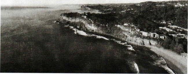
(a) Write two evidences suggest the type of the photograph.
(b)Many people prefer going to water bodies to refresh after a long hard working day. However many cannot identify features around them, as an expert help them to identify three (3) main geomorphic features shown on the photograph
(c)Elaborate in short any two (2) process responsible for the formation of the named features.
(d)Name three (3) economical resources which can be found in the area
SECTION C: (30 MARKS)
Answer two (2) questions from this section
8. On 23rd August, 2022 has been announced as a CENSUS DAY by Tanzanian Government. All Tanzanian citizens must be enumerated
(a) Describe five objectives of conducting census in our country
(b) Explain three limitations of census in African countries
9. Nowadays "Royal Tour" is the common word in Tanzania, it attracts and announces our tourist attractions in the country. By using concrete examples explain five (5) negative effects of Tourism in East Africa.
10. Form four students were given assignment of visiting rural areas of their ancestors to learn different matters relating to socio — economic and cultural values of society of their origin. Among the surprising fact they discovered was the presence of high birth rate in rural areas as compared to urban areas, where fertility rate is low. Present the findings to your teacher by stating six reasons for high birth rate in rural areas
FORM FOUR GEOGRAPHY EXAM SERIES 132
FORM FOUR GEOGRAPHY EXAM SERIES 132

DOWNLOAD LEARNING HUB APP NOW

SORRY, YOU CAN'T VIEW THIS MARKING SCHEME PLEASE DOWNLOAD LEARNING HUB APP FROM PLAYSTORE TO GET FULL ACCESS TO ALL MARKING SCHEME!!
Click Here To Download Learning Hub Tanzania App
SAMAHANI, HUWEZI KUFUNGUA MAJIBU YA MTIHANI, TAFADHALI PAKUA APP YA LEARNING HUB TANZANIA ILI KUWEZA KUFUNGUA MAJIBU YA MITIHANI KATIKA TOVUTI HII!!
Bofya Hapa Kupakua App Ya Learning Hub Tanzania
Hub App
 For Call,Sms&WhatsApp: 255769929722 / 255754805256
For Call,Sms&WhatsApp: 255769929722 / 255754805256  MATOKEO KIDATO CHA IV 2023
FORM ONE SELECTION 2024
Matokeo Darasa VII 2023
SECONDARY REGIONAL EXAMS
PRIMARY REGIONAL EXAMS
FORM VI NECTA REVIEWS
FORM IV NECTA REVIEWS
FORM II NECTA REVIEWS
STD VII NECTA REVIEWS
STD IV NECTA REVIEWS
SECONDARY EXAMS SERIES
PRIMARY EXAMS SERIES
PRIMARY SUBJECT NOTES
SECONDARY SUBJECT NOTES
SECONDARY TOPICAL EXAMS
SECONDARY TOPICAL QUESTIONS
PRIMARY TOPICAL QUESTIONS
PRACTICAL EXAMS & NOTES
SECONDARY REGIONAL EXAMS
DOWNLOAD SUBJECT NOTES
SCHEMES OF WORK (PRIMARY & SECONDARY)
LESSON PLAN
SECONDARY LOG BOOKS
PRIMARY LOG BOOKS
LITERARY WORKS / UCHAMBUZI VITABU
METHALI ZOTE ZA KISWAHILI
Vitendawili Vya Kiswahili
FORM VI RESULTS 2023
FORM FIVE SELECTION 2023
Matokeo KIDATO CHA II 2022
Matokeo Darasa IV 2022
MATOKEO KIDATO CHA IV 2023
FORM ONE SELECTION 2024
Matokeo Darasa VII 2023
SECONDARY REGIONAL EXAMS
PRIMARY REGIONAL EXAMS
FORM VI NECTA REVIEWS
FORM IV NECTA REVIEWS
FORM II NECTA REVIEWS
STD VII NECTA REVIEWS
STD IV NECTA REVIEWS
SECONDARY EXAMS SERIES
PRIMARY EXAMS SERIES
PRIMARY SUBJECT NOTES
SECONDARY SUBJECT NOTES
SECONDARY TOPICAL EXAMS
SECONDARY TOPICAL QUESTIONS
PRIMARY TOPICAL QUESTIONS
PRACTICAL EXAMS & NOTES
SECONDARY REGIONAL EXAMS
DOWNLOAD SUBJECT NOTES
SCHEMES OF WORK (PRIMARY & SECONDARY)
LESSON PLAN
SECONDARY LOG BOOKS
PRIMARY LOG BOOKS
LITERARY WORKS / UCHAMBUZI VITABU
METHALI ZOTE ZA KISWAHILI
Vitendawili Vya Kiswahili
FORM VI RESULTS 2023
FORM FIVE SELECTION 2023
Matokeo KIDATO CHA II 2022
Matokeo Darasa IV 2022


