THE PRESIDENT’S OFFICE REGIONAL ADMINISTRATION AND LOCAL GOVERNMENT
SECONDARY EXAMINATION SERIES
ANNUAL EXAMINATION, NOV -2023
FORM THREE GEOGRAPHY
INSTRUCTIONS TIME:2: 30
- This Paper Consist Two Section A & B With A Total Of Twelve (12) Questions.
- Answer All Questions In Section ‘’A ‘’ And Two Question From Section ‘’B’’
- Section “A” Caries Seventy (15) Marks, Section B’’ Thirty (30) Marks.
- Programmable Calculator, Cellular Phones And Any Unauthorized Materials Are Not Allowed In The Examination Room.
- Write Your Name On Every Page Of Your Answer Sheet.
SECTION A (16-MARKS)
1. For each of items (i) – (ix), choose the most correct answer from among given alternatives given and write its letter on your answer sheet beside item number
- One of the following is a set of factors affecters climate
- Ocean Current, altitude sleet and Barometer
- Distance from sees rainfall, cloud cover, latitude
- Prevailing wind, latitude, rainfall, hygrometer aspect
- Altitude, Temperature, and Earth notation
- Humidity, dew point, atmosphere pressure raingauge
- Soil has physical, chemical and Biological properties which of the following are physical properties of soil
- Colour, clay, texture, structure and porosity
- Porosity, colour, texture, density and structure
- Texture, silt, structure, porosity and sand
- Porosity, profile, structure, Texture and fertility
- Fertility, structure, texture, porosity and colour
- Which statement is true regarding air transport
- It facilitates integration of global economy
- It is the fastest means of transport in the world
- It is the most appropriate means of transport for perishable goods
- It is categorized into local and domestic
- It is one of the most expensive means of Trans sport
- If the minimum temperature recorded in a day to 12°C and maximum temperature recorded in C day is 38°C. Find daily range temperature.
- 50°C
- 26°C
- 50°C
- 26°C
- 55°C
- The following are aspects of physical geography except
- Natural features of the earth
- Structure of the earth
- Distribution of plants and animal
- Population growth and distribution
- Formation and Distribution of land forms
- Suppose you want to invest and engage in commercial livestock-keeping. Which three categories of Commercial livestock-keeping will you consider?
- Pastoralism, sedentary, nomadism
- Traditional, modem and pure livestock keeping
- Traditional livestock keeping, cattle keeping, diary keeping
- Beef livestock; Dairy livestock keeping and sheep keeping
- Pastoralism, cattle keeping, and sedentary animal keeping
- Which of the following is an example of residual mountain
- Sekenke hills in Singida
- Kibo in Kilimanjaro
- Uluguru in Morogoro
- Usambara in Tanga
- Meru in Arusha
- What is the best name of a form of energy that is created by force of flowing water from mountains or high land form?
- Geothermal energy
- Non-renewable energy
- Hydro-electric power
- Waterfalls energy
- Wind energy
- A physical feature in which a piece of land enters the ocean is called
- Cape
- Peninsula
- Gulf
- Straight
- Tributary
- Which of the following is not a component of the solar system
- Sun
- Planet
- Plateau
- Meteoroid
- Asteroid
2. Match the description of features formed by wind in LIST A with corresponding feature in LIST B by writing the letter of correct answer beside item number in answer booklet provide.
| LIST A | LIST B |
|
|
3. Form four students from Anwarite girls secondary school were conducting a land Survey in order to determine linear measurement to establish vegetable gardens and determine bounder of the school land for different uses. In light of this statement answer questions below
- Identify the survey techniques used by students
- Give two importance of survey technique used above
- Explain why survey technique identified above is referred to as simplest method of surveying give 2 reasons
- What was the first step employed in the survey technique you have identified above and why do you think the step is important to survey team?
- Suppose in process of surveying in survey technique. You have identified above, the survey team encountered a river as an obstacle, with aid of well labeled diagram, suggest a suitable method they used to overcome the obstacle.
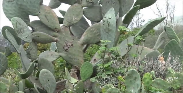
4. Study the following photograph and answer a question that follows.
- With two (2) evidence, name the type of photograph
- What is the name of dominant vegetation shown on photographed area?
- With one evidence from the photograph, suggest the climate of photographed area
- In three (3) points show how vegetations depicted on the photograph adapt to climatic condition of the area
- Name the feature appearing on the back ground of the photograph and describe the geomorphic process responsible for its formation.
5. Study the following table which indicates Electricity generation in giga watts per hour at Kinyerezi power plant in Tanzania from 2016 to 2020
| Source/Year | 2016 | 2017 | 2018 | 2019 | 2020 |
| Hydro-electric power | 1992 | 1769 | 1721 | 2613 | 2124 |
| Gas | 2265 | 2664 | 2872 | 2624 | 2873 |
| Heavy fuel oil | 781 | 1083 | 1133 | 784 | 1188 |
- Draw a multiple bar graph and precisely comment on the graph
- Give two (2) advantage and two (2) disadvantages of using multiple bar graph
- Identify two (2) alternative method which may be used to present statistical information from given table
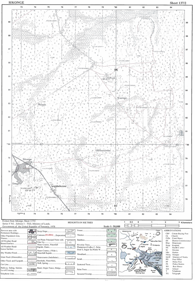
6. Study the map extract of SIKONGE (Sheet 13712) and then answer the questions
- Using the given RF scale, determine the length of the road in Kilometers from grid reference 740829 to grid reference 760881
- Determine the area at the right hand side of northing 800 in km2
- With examples, name two (2) ways used to show height of the land on the mapped area
- Under what climatic region is mapped area found?
- Draw and label eight features of ocean floor
- Explain six (6) challenges facing green tourism
SECTION C. (30 MARKS)
Answer any two (2) questions
9. Solar energy is the friendliest source to environment. However it is not harnessed in large quantities on other sources. What might be reasons for the problem and possible solutions give six points
10. Tanzania is known to have a conducive and prospective geological environment with abundant potential of mineral deposits. In six (6) points explain the importance of mining sector to economy of Tanzania
11. In six points, explain factors affecting soil formation in Ngara District.
 |
FORM THREE GEOGRAPHY EXAM SERIES 154
FORM THREE GEOGRAPHY EXAM SERIES 154
THE PRESIDENT’S OFFICE MINISTRY OF EDUCATION, REGIONAL ADMINISTRATION AND LOCAL GOVERNMENT
COMPETENCY BASED SECONDARY EXAMINATION SERIES
GEOGRAPHY FORM THREE
TIME: 2 HOURS NOVEMBER 2022
Instructions
- This paper consists of section A, B, and C
- Answer all questions in Section A and B and two (02) questions from section C
- Section A carries fifteen (15) marks, Section B carries fifty five (55) marks and Section C carries thirty (30) marks
- Map extract of Babati (Sheet 85/1) is provided
- Programmable Calculator and Cellular phones are not allowed in Examination room.
- Write your Examination number on every page of your answer sheet.
SECTION A (15 Marks)
Answerallquestionsinthissection
- For each of the items (i) – (x) choose the correct answer from among the given alternatives and write its letter besides the item number in the answer booklet provided below.
- Ally put an iron nail in the soil, a year later he came to find his iron nail nearly to be like the soil itself, what process had taken place over the iron nail?
- Hydrolysis C. Carbonation
- Solution D. Oxidation E. Hydration
- The greenhouse gases can deplete the Ozone layer among other effects of Ozone layer depletion can also cause.
- Good visibility C. Skin cancer
- Clouds formation D. Environmental lapse rate E. Glaciations
- The maximum and minimum bulb thermometers are likely to give the same readings, when the air
- Is saturated C. Is wet
- Is not saturated D. is dry E. Is very hot
- Patrick noticed the pressure of 760mb at sea level. At the same time, what will be the pressure of Dodoma 1500m above sea level?
- Ally put an iron nail in the soil, a year later he came to find his iron nail nearly to be like the soil itself, what process had taken place over the iron nail?
A. 150mb B. 910mb C. 610mb D. 15mb E. 760mb.
- You are asked to select the type of soil that is both, permeable and impermeable depending on the extent of saturation. What will be your selection among the following?
- Loamy B. Silty C. Sandy D. Sedimentary E. Clay
- Dowasa manager wants to construct a well that will serve water supply permanently to the society of Dodoma city. Which layer would you advice to be reached by the pipes to tape the underground water?
- The intermitted zone C. The zone of non-saturation
- The aquifer D. The acquiclude E. The water table.
- Akilimali grows flowers, vegetable and other plants that cause aesthetic environment what kind of agriculture is that?
- Aquaculture B. Horticulture C. Garden D. Port culture E. Botanism
- What would be the name of the sand bar that might join the Dar Es salaam and the Zanzibar shores, being constructed by wave action?
- Mudflat B. Spit C. Beach D. Tombolo E. Cuspate foreland
- Your Geography teacher has planned to take you as his Geography students to visit European countries during summer season which month would you advise him to go?
- January B. September C. December D. March E. June
- A feature you do not to see in Tanga, Tanzania in the Amboni cavern.
- Stalagmites B. Stalactites C. Levees D. Natural pillars E. Underground rivers
- Match the description of desert landforms in listA with the corresponding names in listBby writing the letter of the correct response beside the item number in the answer booklet (s)
| LISTA | LISTB |
|
|
SECTION B (55 MARKS)
Answerallquestionsinthissection
- Study the map extract of Babati (Sheet 85/1) and answer the following questions;
- With an evidence suggest two drainage patterns found in the mapped area
- Suggest the hemisphere from which mapped area is found. (give one evidence)
- Describe the vegetation distribution in the mapped area.
- Find the area of Lake Babati (Answer in km²)
- Identify any two (2) economic activities which might take place in the mapped area. And give two importance for each activity
- Mjuni is selling school bags. He always records data of his retailing in a note book. His friend John is working in a super market as a shopkeeper and he told him about the simplest way of presenting data for single variable against time. John showed his friend the following table showing data of school bags received from 2011 to2017.
| Year | 2011 | 2012 | 2013 | 2014 | 2015 | 2016 | 2017 |
| School/Bagsreceived | 90 | 100 | 40 | 50 | 20 | 70 | 120 |
- Name the two (2) simplest methods to present the data above.
- Explain three (3) cons and pros of presenting the data by the simple methods listed in (a) above.
- Present the given statistical information by using simple bar graph
5. There was a serious conflict between farmers whose plots was nearby each other. They tried to resettle the conflict but they failed and later on they decided to consult the Village Executive Officer to seek the resolution. The Village Executive Officer decided to send the village land resolution team to the field. The team decided to use the method of linear measurement.
- Identify the method of taking measurement used
- List down any four instruments that were used
- If the team consisted of three personnel’s in taking linear measurement. Who are those?
- Describe any four significances of using the method identified in ( a) above
- The villagers at Matombo village in Morogoro District were told to measure the distance of Msalabani secondary school compound. But they come up with wrong linear measurement. By using the knowledge of simple land survey describe;
- The method used by the villagers and why?
- The five (5) instruments that were supposed to be used during the surveying process.
- Three (3) sources of the wrong linear measurement.
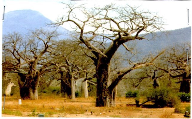
- Carefully study the photography provided and answer the questions that follow;
- What is the name of feature seen on the photograph?
- Suggest the type of climate of the area where this photograph was taken.
- List three (3) characteristics of climate suggested in (b) above.
- Suggest two areas in Tanzania where this photography might have been taken.
- With evidences comment on the type of the photograph shown.
- Comment on two (2) uses of feature shown in this photo.
SECTION C (30marks)
Answertwo(02)questions fromthissection
8. a) An announcement from the ministry concerning with industries directed that, government police may play a great role in determining the location of industries, hence the minister argued that, ‘we discourage the concentration of industries in one place” what are the reasons led a minister to argue so? Four points
b) East Africa is struggling to establish several industries so as to fasten the growth of economy. Thus different types of manufacturing industries have been introduced, as an expert in manufacturing, industries identify groups of manufacturing industries in the region concern. Give six groups with vivid examples
9. Mdilidili is a village whereby villagers are walking over long distance to fetch water, how distance to water source from household affect a girl child? Briefly Explain (five points)
10. A Geography teacher at Maji Marefu Secondary school taught his students that “Soil has physical, chemical and biological properties”. With facts and vivid example, you as an expert in Geography clarify six (6) properties of soil which were taught by Geography teacher at Maji Marefu Secondary School to his students.
FORM THREE GEOGRAPHY EXAM SERIES 107
FORM THREE GEOGRAPHY EXAM SERIES 107
PRESIDENT’S OFFICE
REGIONAL ADMINISTRATION AND LOCAL GOVERNMENT
FORM THREE ANNUAL EXAMINATIONS
013GEOGRAPHY
(For Both School and Private Candidates)
Time: 3:00 HoursDecember 2020 p.m.
Instructions
- This paper consists of sections A, B and C, with total of ten (10) questions
- Answer ALL questions in section A and B and two (2) questions from section C
- Map extract of (265/2) Ilonga Sheet is provided
- Credit will be given for the use of recreant diagrams
- Write your examination number on each answer sheet you have used.
SECTION A (15 Marks)
Answer all questionsin this section
1. For each of the items (i) – (x), choose the correct answer from among the given alternatives and write its letter besides the item number in the answer booklet provided.
(i)What is a proper name for the study of the description of the earth?
Asolar system
BAstronomy
CGeography
DEnvironment
EMetrology
(ii)You have been visited the coastal area of Bagamoyo and you find the forests with deep roots and roots project above the mud and water to absorb oxygen, what kind of forest is that?
ATropical forest
BMangrove forest
CConiferous forest
DDeciduous forest
ETemperate forest
(iii)If the time at town X is 150E is 12:00 noon what could be the longitude town Y if it is 8:00 am?
A150E
B300W
C300E
D450W
E450E
(iv)Mrs Kilua was wondering how fragments are worn out during collision against each other at Kondoa river during rainy season, her daughter tells her that process is known as ……
AHydraulic action
BAttrition
CAbrasion
DCorrosion
EHydrolysis
(v)The Maasai around Oldonyo Lengai mountain were wondering the way mountain vomiting fire and smoke, they believe that the mountain was possessed by bad evils, tell them is not evils but is …………..
AVolcanic eruptions
BTectonic movements
CMass wasting
DFire from God
EFaulting
(vi)Suppose you want to carry out a field study on the atmospheric conditions suitable for growth of maize on a farm village. What are the best weather components to be considered…?
ARainfall and wind
BRainfall and could cover
CMoisture and sunshine
DRainfall and temperature
EPressure and humidity
(vii)Last year people of Bukoba District experience shaking of crustal rocks which lead to destruction of properties and death of people. Where this shaking does originated inside the earth’s crust?
AAt the focus
BAt the epicentre
CAt the fault
DAt the Lake Victoria
(viii)The process of peeling off and falling of rock mass is called
ADisintegration
BWeathering
CMass wasting
DErosion
EExfoliation
(ix)Workers who were working at Government offices in Dar es salaam are now moving to Dodoma as their new offices. Identify the type of that movement
AMigrants
BEmigrants
CEmigration
DImmigration
EImmigrants
(x)Recently in Rwanda the land with their vegetation was sliding down a slope and people were busy in taking photos and wondering to that situation, tell them what type of geological process was taking place
AErosion and deposition
BDenudation and transportation
CLand slide and erosion
DMass wasting and transportation
ELandslide and deposition
2.Match the letter of the correct response beside the item number in the answer sheet provided.
| LIST A | LIST B | |
| i | Fineness and coarseness of soilparticles | A. Soil type B. Soil profile C. loam soil D. soil texture E. Soil structure F. Soil fertility G. Soil organic matters H. Soil chemistry I. Soil erosion J. Soil water K. Soil air |
| ii | Removal of materials from surface of land | |
| iii | Vertical section of the soil to the underlying rocks | |
| iv | Status of soil with respect to amount of elements necessary for plants growth | |
| v | Residues that have decomposed and mixed with soil mass | |
SECTION B (55 Marks)
Answer all questions from this section
3Study the map extract of Ilonga (sheet 265/2) and answer the following questions.
- Measure the distance covered by the river in kilometre from grid reference 630000 to 600979
- Use the square methods to calculate the area covered by Namihondo pond.
- With evidence, mention three (3) economic activities which may be conducted on a mapped area
- Describe the nature of relief of the area
- With one reason, suggest the type of climate
- Identify any three (3) factors which have influenced the population distribution of Ilonga town.
4.Carefully study the data below which shows the exports of tea from Kilimanjaro in tones.
| YEAR | TEA PRODUCTION (In Tonnes) |
| 1981 | 7,000 |
| 1982 | 3,000 |
| 1983 | 10,000 |
| 1984 | 5,000 |
| 1985 | 2,000 |
| 1986 | 12,000 |
| 1987 | 16,000 |
| 1988 | 6,000 |
| 1989 | 15,000 |
| 1990 | 3,500 |
a)Name the two simplest methods of presenting the data
b)Outline two values of presenting the data by simple methods mentioned in (a) above
c)Present the given statistical data by using divergent bar graph.
5. (a)What is meant by Moraine erosion?
(b) Describe four (4) processes which are involved in Moraine erosion.
6.(a) Distinguish fold mountains from volcanic mountains
(b) Briefly explain how the rift valley is formed
7.Study carefully the photograph below then answers the questions that follow: -
- Name the type of photograph
- Describe the possible climate of the area
- Suggest four economic activities that might be taking place in the area
- Suggest three possible regions in Tanzania where the photograph might have been taken
SECTION C. (30 Marks)
Answer two (2) questions from this section.
8.Explain any six objectives of constructing the Stigler’s gorge hydro- electric power in Tanzania.
9.Mage’s grandmother used to cultivate many crops in small area, using local seeds and hand hoe and now she is blaming that she harvests nothing in five years and she is complaining that her neighbours are the one who cause this problem. Explain to her six ways on how she can improve her farming system instead of complaining to her neighbours.
10.Explain six human factors which influences population distribution and density in Tanzania
FORM THREE GEOGRAPHY EXAM SERIES 38
FORM THREE GEOGRAPHY EXAM SERIES 38

DOWNLOAD LEARNING HUB APP NOW

SORRY, YOU CAN'T VIEW THIS MARKING SCHEME PLEASE DOWNLOAD LEARNING HUB APP FROM PLAYSTORE TO GET FULL ACCESS TO ALL MARKING SCHEME!!
Click Here To Download Learning Hub Tanzania App
SAMAHANI, HUWEZI KUFUNGUA MAJIBU YA MTIHANI, TAFADHALI PAKUA APP YA LEARNING HUB TANZANIA ILI KUWEZA KUFUNGUA MAJIBU YA MITIHANI KATIKA TOVUTI HII!!
Bofya Hapa Kupakua App Ya Learning Hub Tanzania
Hub App
 For Call,Sms&WhatsApp: 255769929722 / 255754805256
For Call,Sms&WhatsApp: 255769929722 / 255754805256  MATOKEO KIDATO CHA IV 2023
FORM ONE SELECTION 2024
Matokeo Darasa VII 2023
SECONDARY REGIONAL EXAMS
PRIMARY REGIONAL EXAMS
FORM VI NECTA REVIEWS
FORM IV NECTA REVIEWS
FORM II NECTA REVIEWS
STD VII NECTA REVIEWS
STD IV NECTA REVIEWS
SECONDARY EXAMS SERIES
PRIMARY EXAMS SERIES
PRIMARY SUBJECT NOTES
SECONDARY SUBJECT NOTES
SECONDARY TOPICAL EXAMS
SECONDARY TOPICAL QUESTIONS
PRIMARY TOPICAL QUESTIONS
PRACTICAL EXAMS & NOTES
SECONDARY REGIONAL EXAMS
DOWNLOAD SUBJECT NOTES
SCHEMES OF WORK (PRIMARY & SECONDARY)
LESSON PLAN
SECONDARY LOG BOOKS
PRIMARY LOG BOOKS
LITERARY WORKS / UCHAMBUZI VITABU
METHALI ZOTE ZA KISWAHILI
Vitendawili Vya Kiswahili
FORM VI RESULTS 2023
FORM FIVE SELECTION 2023
Matokeo KIDATO CHA II 2022
Matokeo Darasa IV 2022
MATOKEO KIDATO CHA IV 2023
FORM ONE SELECTION 2024
Matokeo Darasa VII 2023
SECONDARY REGIONAL EXAMS
PRIMARY REGIONAL EXAMS
FORM VI NECTA REVIEWS
FORM IV NECTA REVIEWS
FORM II NECTA REVIEWS
STD VII NECTA REVIEWS
STD IV NECTA REVIEWS
SECONDARY EXAMS SERIES
PRIMARY EXAMS SERIES
PRIMARY SUBJECT NOTES
SECONDARY SUBJECT NOTES
SECONDARY TOPICAL EXAMS
SECONDARY TOPICAL QUESTIONS
PRIMARY TOPICAL QUESTIONS
PRACTICAL EXAMS & NOTES
SECONDARY REGIONAL EXAMS
DOWNLOAD SUBJECT NOTES
SCHEMES OF WORK (PRIMARY & SECONDARY)
LESSON PLAN
SECONDARY LOG BOOKS
PRIMARY LOG BOOKS
LITERARY WORKS / UCHAMBUZI VITABU
METHALI ZOTE ZA KISWAHILI
Vitendawili Vya Kiswahili
FORM VI RESULTS 2023
FORM FIVE SELECTION 2023
Matokeo KIDATO CHA II 2022
Matokeo Darasa IV 2022


