PRESIDENT OFFICE REGIONAL ADMINISTRATION AND LOCAL GOVERNMENT
SECONDARY EXAMINATION SERIES
COMPETENCE BASED ASSESSMENT
013 GEOGRAPHY FORM ONE
ANNUAL EXAMINATION – 2023
Time: 2:30 Hours
Instructions
- This paper consists of sections A, B and C with a total of ten (10) questions.
- Answer all questions.
- Section A and C carry fifteen (15) marks each and section B caries seventy (70) marks
- All writing must be in blue or black ink
- All writing must be written in the space provided.
- Cellular phones, calculators and any unauthorized materials are not allowed in the assessment room.
SECTION A (15 MARKS)
1. For each of items (i) – (x) choose the correct answer from alternative given and write it against item given.
i. What type of rainfall occurs when warm moist wind from the Indian Ocean comes into contact with the cold air mass from land mass?
- Orographic rainfall
- Frontal rainfall
- Convectional rainfall
- Cyclonic rainfall
ii. John was told by his teacher that the earth makes one complete rotation every twenty four-hour. From which direction does it rotate?
- West to East
- South to North
- North to South
- East to west
iii. Anna and Asha were required to calculate of a road on a map in Kilometers provided that; the map scale was 1:50,000 and the distance measured on the map was 10cm. Which among the following was the actual distance presented by them?
- 10km
- 5km
- 15km
- 20km
iv. If the temperature for Dar-es-Salaam at the sea level is 30°C, what is the temperature for Moshi at 300M above the sea level?
- 31.2°C
- 28.2°C
- 30.2°C
- 32.2°C
v. Which of the following is an example of Residual mountain in Tanzania
- Mount Sekenke
- Mount Kilimanjaro
- Mount Ruwenzori
- Mount Meru
vi. A branch of geography that enable leaner to acquire practical skills that enhance their ability for interpreting both skills, this is called
- Physical geography
- Practical geography
- Human and economic geography
- Skills geography
vii. A business woman from Siberia who is found in Eastern part went to Alaska which is found in Western part, for her business trip. What will happen to her in concept of gain and losing the day?
- Gain a day
- Loses a day
- Gain and loses a day of the some time
- None of the above
viii. The five essential of the map are the one which make the map complete the essential which is used in measuring the distance in the map is known as
- Scale
- Key
- Compass
- Title
ix. The graph which shows both temperature and rainfall characteristics is called.
- Bar graph
- Climatorgraph
- Isograph
- Isobar
x. A collection of salt tolerant tree and scrubs grow on estuaries and deltas of tropical coastline is
- TropicalMansoon forest
- Mangrove forest
- Equatorial forest
- Deciduous forest
2. Match the type of Natural forest in LIST A with the corresponding description in LIST B by writing the letter of the correct response in the box below.
| LIST A | LIST B |
|
|
SECTION B: (70 Marks)
Answer all questions
3. (a)Amani was wondering to see the rain along the eastern slope of Mt. Kilimanjaro leaving the west with rain shadow effect
(i) Which type of rainfall on eastern side
(ii) With aid of diagram show type of rainfall experienced by Amani.
(b)Describe factors that determine climate of a place
4, (a) On any given map you can locate position of different things by using different methods. Identify the four methods which can be used to locate positions
(b)Convert 1:50,000 into statement scale
(c)Draw signs and symbols of the following
- Mountain
- Swamp
- School
- Railway
5. Study carefully the data recorded from major weather station from 4th January 2023 to 11st January 2023 and answer question that follow
| Day | Mon day | Tues day | Wednesday | Thursday | Friday | Saturday | Sunday |
| Temp C° | 19 | 20 | 20 | 21 | 19 | 21 | 20 |
| Rain (mm) | 35 | 47 | 40 | 43 | 27 | 41 | 39 |
- Calculate weekly average temp in centigrade
- Complete the weekly rainfall in millimeters
- Find temperature range with the week
- Which is the wettest day in a week? Why?
- What were the coldest days in a week? Why?
6. Juma and his friend were Watching news on Television on weather forecasting, that tomorrow Morogoro region will experience high temperature
- As a form one student help Juma explain why the forecast did happen as expected
- Short list four elements of weather
7. During holiday, Pendo travelled from Dar-es-Salaam to Mbeya but when she reached at Iringa she experienced different climate which differ from that of Dar-es-Salaam and Morogoro.
- Help Pendo identify five causes of climate variations
- Give five differences between climate and Weather
8. The earth is not flat but round. Justify this statement using six points
9. (a)Explain what will happen when
- The earth process between moon and the sun
- The moon passes between sun and Earth support using diagram.
(b)Identify four resultant effects of earth rotation
SECTION C (15 Marks)
10. (a) How does Tanzania benefit from solar Energy
(b)In which ways does society benefit from weather forecasting?
FORM ONE GEOGRAPHY EXAM SERIES 152
FORM ONE GEOGRAPHY EXAM SERIES 152
THE PRESIDENT’S OFFICE MINISTRY OF EDUCATION, REGIONAL ADMINISTRATION AND LOCAL GOVERNMENT
COMPETENCY BASED SECONDARY EXAMINATION SERIES
GEOGRAPHYFORM ONE
TIME: 2 HOURS NOVEMBER 2022
Instructions
1. This paper consists of sections A, B and C.
2. Answer all questions in sections A and B and only one (1) question in section C.
3. Section A carries fifteen (15) marks, section B carries seventy (70) marks and section C carries fifteen (15) marks.
4. All answers must be written in the spaces provided.
5. Cellular phones, calculator and unauthorized materials are not allowed in the examination room.
6. Write your Examination Number on the top right on every page.
SECTION A (15 Marks)
Answer allquestions in this section
1. For each of the following items (i) – (x), choose the correct answer from among the given alternatives and write its letter in the box provided.
- The students learned about lines measured in degrees, minutes and seconds of a point on the earth’s surface north or south of the equator. What is the common name of these lines?
A. Great circle
B. Latitude
C. Longitude
D. Greenwich.
- Mr. Chande went to Brazil located 55oW to watch a live football match between Brazil and Germany, a Brazil player scored a goal for his team at 4:00 pm. What will be a time at Mwanza in Tanzania located at 35oE?
A. 4:00 pm
B. 6:40 pm
C. 10:40 pm
D. 10:00 pm.
- The tourists enjoyed the temperature of Dar es Salaam which was 30oC at the sea level. They also planned to travel from Dar es Salaam to Kilimanjaro. Which is 2500 meters above the sea level. What will be the temperature experienced by the tourists in Kilimanjaro?
A. 5oC
B. 0oC
C. 7oC
D. 90oC.
- Mr. Kaula constructed map of his village without indicating the scale of that map. What effect will be faced by the user of such map?
A. Failure to identify village boundary
B. Failure to identify the actual size of the village
C. Ability to identify the actual size of the village
D. The content of the map will not be understood.
- Form one student visited his grandmother at the village, he heard his grandmother saying it may rain today due to sound of frog. That way of prediction weather is called:
A. Modern weather forecast
B. Regional weather forecast
C. Traditional weather forecast
D. Grandmother watched TV.
- The periodic rise and fall in the level of water in the ocean is known as:
A. Tides B. Waves C. Ocean currents D. Wind
- Amina moves to the west and crosses the International Date Line. What happens with regard to time?
A. No time is gained or lost B. One whole day is lost
C One whole day is gained D. One whole day is repeated
- A scale of 4cm representing 18km on the ground, will be represented by representative fraction (R.F) scale as
A. 1:900,000 B. 1:1,800,000 C. 1:450,000 D. 2:800,000
- A channel diverging from Main River and flowing into the sea or lake by a separate mouth is called.
A. Distributary B. Stream C. Tributary D. River basin
- The winds which blow from the sea to the land is called; a) Wind breeze b) Sea breeze c) Land breeze d) Ocean currents
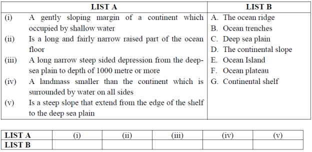
2. Match the description of the features of the ocean floor in LIST A with the corresponding features in LIST B by writing the letter of the correct response below:
SECTION B (70 Marks)
Answer all questions in this section.
3. In each of the following items (i – x), write True if the statement is correct or False if the statement is not incorrect.
i. Global warming is a decrease in temperature on the earth surface
___________
ii. Reforestation is a process of cutting down all trees without replacement _______________
iii. Mozambique current causes rainfall along the eastern coast of Tanzania
_______________
iv. Lapse rate is the gradual decrease or increase in temperature as altitude increases or decreases ________________
v. Hydrological cycle is a continuous circulation of water from earth’s surface to the atmosphere ______________
vi. Dry bulb and wet bulb thermometers are used when measuring humidity, when the air is not saturated the two thermometers show the different readings and when the air is saturated the two thermometers show same readings ______________
vii. Wind is air in motion from low pressure to high pressure area
_____________
viii. A longitudes is an angular distance measured in degree East and South of the equator_________________
ix. The area from which river system collects its rain water is called catchment area______________
x. People living in Dar es Salaam see the sunrise earlier than in Kigoma Because people in Kigoma sleeps longer ______________
4. Study carefully a data recorded from Major weather station January to December 2020 and answers the question below.
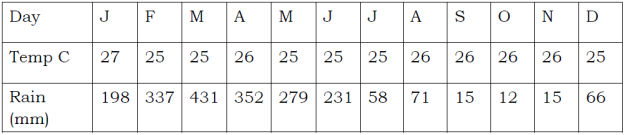
i. Calculate the annual average temperatures
ii. Compute the annual rainfall
iii. What type of climate is this?
iv. Give two reasons to support the choice of the climate mentioned in (iii) above
v. In which part of Africa this climate is found?
5. (a). Convert the following scales according to the instructions given
i. “One centimeter on the map represents half kilometer on the ground” Convert this scale into Representative fraction (R.F) scale.
ii. 1:150,000. Convert into statement scale.
b). State the directions of the following bearing.
i. 2700 __________________________________________________________
ii. 1350___________________________________________________________
c). How can we locate positions on map?
i. _______________________________________________________________
ii. _______________________________________________________________
iii. _______________________________________________________________
iv. _______________________________________________________________
6. Form one students at Buhongwa Secondary School visited the weather station at Mwalimu Nyerere International Airport, they saw various instruments and devices. One device was white wooden box, a box had louvers all the sides, and double boarded roof. It mounted on a stand 121cm above the ground, it was the first time for form one students to see that device.
(a) As a form one student identify that device:
(b) Why the device was made like that
(c) Name two (2) instruments kept in it
(i)
(ii)
(d) Mention two (2) uses of the instruments mentioned above.
(e) List two (2) importance of that station in our daily life
(i) __________________________________________________________________
(ii) __________________________________________________________________
7. (a) Madam Bahati is a geography teacher at Karibuni Secondary School, she has taught
her students on branches of that subject. As a form two student describe to us what she said on branches of that subject.
(b) From (a) above, what are the likely four (4) significance of teaching that subject in our schools
8. Carefully study the map given and answer the following questions:
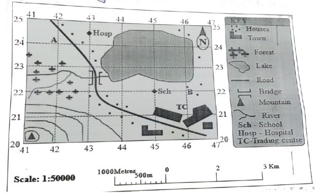
(a) Identify two (2) ways that can be used to calculate area of lake on mapped area
(i) ___________________________________________________________________
(ii) ___________________________________________________________________
(b) Use one of the method mentioned above to calculate area covered by lake
_________________________________________________________________________________
(c) Identify features or things shown at grid references
(i) 450220 = _______________________________________________________________
(ii) 465245 = _______________________________________________________________
(d) Identify elements of a good map that has been shown in a given map
(i) _______________________________________________________________
(ii) _______________________________________________________________
(iii) _______________________________________________________________
(e) State the functions of each element mentioned in (d) above
(i) _______________________________________________________________
(ii) _______________________________________________________________
(iii) _______________________________________________________________
(iv) _______________________________________________________________
9.(a) “Geography” can be defined as the study of the distribution and interrelationship of phenomena in relation to the earth’s surface. Briefly explain how geography relates with:
(i) Biology
(ii) Commerce
(b) Explain the economic importance of studying geography:
SECTION C (15 Marks)
10. Mwajuma and Asha are the students at Maweni Secondary School. One day they were looking pictures in a certain book and met with a good picture showing how the earth looks like. After looking at that picture Asha didn’t want to believe that the earth appears in that way. As a form two student give six (6) facts to support the shape of that picture observed by them.
FORM ONE GEOGRAPHY EXAM SERIES 112
FORM ONE GEOGRAPHY EXAM SERIES 112
THE PRESIDENT’S OFFICE
MINISTRY OF EDUCATION, REGIONAL ADMINISTRATION AND LOCAL GOVERNMENT
SECONDARY EXAMINATION SERIES
GEOGRAPHY ANNUAL EXAMINATION
FORM ONE-NOVEMBER 2021
GEOGRAPHY
TIME: 2:30 Hours
![]()
Instructions
- This paper consists of section A, B and C with a total often (10) questions.
- Answer all questions in section A and B and two (2) QUESTIONS in section C.
- All writing must be in blue of black ink.
- All answers must be written in the space provided.
- Cellular phones, calculator and any unauthorized materials are not allowed in the examination room.
- Write your examination number at the top right corner of every page.
SECTION A (25 MARKS)
Answer all questions in this section.
1. For each of the items (i) — (x), choose the correct answer from among the given alternative and write its letter in the box provided.
i.When the spring equinox does occurs?
- 3 rdJanuary
- 23 rdSeptember
- 21 st march
- 4th July ii.
- The stretch of land where standard time is accepted throughout a longitudinal zone 15 0 in width.
- Time zone
- Greenwich mean time
- Standard time
- Prime meridian time
- Deflection of wind and daily rising and falling of tides are among the Effects of?
A. Earth's movement B. Earth's rotation
- Earth's revolution
- Aphelion and perihelion
iv. Ocean water occupies about …... . Percent of the earth's surface,
A. 21
B. 29
C. 71
D .70
- The streams that join together to form main streams.
- Distributaries
- Drainage
- Tributaries
- River basin
- If the temperature at dare s salaam which is at sea level is 320c, what will be the temperature at a place where altitude is 1,500meters?
- O.60c
- 230c
- 90c
D. 41 0c
- Dormant volcanic mountains are those which
A. Have never experienced eruptions.
- Have erupted once but are no longer active
- Continue to erupt occasionally
- Erupt when there is an earth quake
- The region which found between 50 and 200 North and South of Equator
- Savanna grassland
- Equatorial region
- The hot deserts
- Mediterranean climate
- If the temperature of station X is 1040F, What is the temperature of the same station in 0C.
- 420C
- 360C
- 210c
- . 400C
(x)Isohyets are the lines on a map which join all places with the same
- Height above the sea level
- Amount of rainfall
- Atmospheric pressure
- Natural vegetation
- Match the items in List A with responses in List B by writing the letter of the correct response below the corresponding item number in the table provided.
| List Å | List B |
| |||||
| i. Rocks which allows water to pass through ii. Water which originates from precipitation such as snowfall iii. Water from greater depths of earth's surface as a result of volcanic activity iv. The rocks which have pores through which water can filtrate v. Salt extraction, fishing, sand, seaweeds and decorative items such as corals and sea shells |
|
| |||||
| List A | 1 | 11 | 111 | iv | v | ||
| List B |
|
|
|
|
| ||
- In each of the following items (i-x ), write TRUE if the statement is correct or FALSE if the statement is not correct.
- The moon takes 31 days to make a complete revolution round the earth.
- Continental shelf is a long and fairly narrow raised part of ocean floor.
- Isokinetic is the lines on the map joining places with the same wind movements..
- Altitude, latitude and ocean current are the factors that affect temperature..
- Topographical maps used to express descriptive information such as pressure, temperature and crops..
- The differences between weather and climate based on time and area covered..
- Always stream channel carries more water in Morogoro region during the dry seasons
- The planets are called wandering stars in Greek………………..
- Coal, petroleum, oil, natural gas and wind are examples of nonrenewable resources...
- The earth rotates from west to east..................
SECTION B (45marks)
Answer all questions in this section
4. (a) Outline four features of linear scale
(b) Briefly describe five essentials of a map
5. Study the sketch map provided and answer the questions that follow:
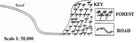
- Name the type of scale which has been used to represent this map.
- Mention three ways which can be used to measure the distance of the road in the sketch map.
- Briefly describe three important basic components of a map.
- Convert the given scale into a statement.
- Mention three methods which can be used to calculate the area of the forest shown on the sketched map.
6. Study the following climatic table and answer the questions that follow.
Station Y
| Months | Jan | Feb | March | Apr | May | June | July | Aug | Sep | Oct | Nov | Dec |
| Temp(0 C) | 22.5 | 25 | 25 | 25.5 | 25.5 | 25.5 | 25.5 | 25.5 | 26.1 | 26.1 | 26.1 | 26.6 |
| Rainfall(mm) | 198 | 340 | 431 | 350 | 280 | 230 | 160 | 71 | 15 | 12 | 15 | 66 |
- Suggest the type of climate of station Y.
- Calculate the daily mean temperature.
- Find the mean annual temperature.
- Find the annual rainfall for station Y.
- Mention any four crops that can be grown in station Y.
7.(a) Outline five evidences to verify that the Earth is spherical.
![]() (b) Differentiate the following terms:
(b) Differentiate the following terms:
![]() (i) Meteors and satellites
(i) Meteors and satellites
(ii) Sea and lake
8.(a) Outline four ways of determining direction of a place on a map.
(b) List four features of the Representative Fraction (RF) scale.
(c) Suggest two ways of measuring areas with irregular shapes.
9.(a) Mention five features of the ocean floor.
(b) Name the five largest oceans in the world.
(c) Mention five largest lakes in the world.
(d) Differentiate the following terms:
(i)Temperature and humidity
(ii)Minimum and maximum thermometer
(iii) Pressure and wind
10. (a) Distinguish the following terms:
- Solar system and solar energy
- Raw materials and manufacturing industries
- Map and scale of a map
- Plateau and mountain
(b)
- Define lunar eclipse.
- Draw a well labelled diagram to show lunar eclipse.
FORM ONE GEOGRAPHY EXAM SERIES 76
FORM ONE GEOGRAPHY EXAM SERIES 76
PRESIDENT'S OFFICE
REGIONAL ADMINISTRATION AND LOCAL GOVERNMENT
ANNUAL EXAMINATION
GEOGRAPHY FORM ONE
NAME…………………………………………..CLASS……………………………TIME: 2HRS
INSTRUCTIONS.
- This paper consists of sections A, B and C with a total of ten (10) questions.
- Answer all questions in section A and B and two (2) questions from section C
- All writing must be in blue or black ink.
- All answers must be written in the space provided.
- Calculators, cellular phones and any unauthorized materials are not allowed in the examination room.
- Write your Examination Number at the top right corner of every page.
SECTION A (25 Marks)
Answer all questions in this section.
SECTION A:
1. For each of the following (I-X) choose the most correct answer from the given alternatives and write its letter besides the item number.
(i) Temperature decreases with altitudes at the rate of:-
(a) 1.6C˚ for every 100 metres
(b) 16C˚ for every 100 metres
(c) 0.6C˚ for every 100 metres
d) 0.16C˚ for every 100 metres
(ii) The rotation of the earth causes the following except?
(a) Day and night
(b) The different of one hour between two meridians of 15˚ width.
(c) Seasons
(d) The deflection of winds and ocean current.
(iii) Which of the following is the proper arrangement of the first five (5) planets of the solar systemaccording to the distance from the Sun starting with nearest planet?
(a) Mercury, Earth, Venus, Saturn and Mars.
(b) Mercury, Venus, Earth, Mars and Jupiter.
(c) Venus, Mercury, Mars, Earth and Jupiter.
(d) Mars, Earth, Mercury, Jupiter and Venus.
(iv) One of the following groups are features of the ocean floor:-
(a) Ridge, basin, plateau and waterfalls.
(b) Continental shelf, basin and waterfalls.
(c) Host, plain, basin and volcano
(d) Trend, Continental shelf and continental slope.
(v) Isobars are lines drawn on a map to join all places with the same:-
(a) Amount of rainfall
(b) Height above sea level
(c) Amount of Temperature
(d) Atmospheric pressure
(vi) The condition of atmosphere recorded over a long period of time is:-
(a) Climate
(b) Temperature
(c) Weather
(d) Atmospheric pressure.
(vii) The side of a Mountain facing away from the direction of the wind is called?
(a) Fore side
(b) Wind wards side
(c) Front
(d) Lee ward side.
(viii) The best description of the term Geography:-
(a) The study of the solar system
(b) The study of the planets.
(c) The study of man in relation to his environment
(d) The study home of man.
(ix) The planets:-
(a)Are bodies that rotate around the Sun
(b)Are bodies that revolve around the Sun.
(c) Are stars.
(d) More of the above.
(x) Which are is the Large Scale among the following?
(a) The denominator is usually medium
(b) The denominator is small
(c) The denominator is large
(d)The denominator range from large to medium
2. Match the items in column A with those in column B by writing the letter of the correct answer against its corresponding item number in column A.
| LIST A | LIST B |
| (i) Land that is completely surrounded by water. (ii) The planet that is known to support life is……. (iii) Geography originated from two Greek words “geo” and…… (iv) Farthest position of the earth from the sun (v) The wind in which blows from the sea to the land | A. Anemometer B. Fold Mountain C. Island D. Isotherms E. 0.6 C˚ for every 100 metres. F. Isohyets G. Sea breeze H. Aphelion I. Earth J. Convectional rainfall K. Graphein L. Perihelion. |
3. Write TRUE or FALSE against the following statements.
(i) Statement scale is expressed in fraction___________
(ii) Winter is the one of the seasons of the year__________
(iii) Elements of weather are the same as element of climate___________
(iv) Winds blows from areas of low pressure to high pressure____________
(v) The Sun is the source of all energy____________
(vi) Humidity is measured by a Hygrometer__________
(vii) Representative Fraction Scale (R.F) is a way of expressing the scale of a map by the one of linear scale_________
(viii) Fold Mountain is the result of high pressure and temperature under the ocean floor_________
(ix) Lake Tanganyika is a rift Valley Lake__________
(x) Television is an example of Mass Media_______
SECTION B (45 Marks)
Answer all questions in this section.
4. Mention five element of Weather.
5.(a)List five essentials of a good Map
(b) Mention three (3) ways in which the scale of the Map can be represented.
(i)…………………………………………………………….
(ii) ……………………………………………………………
(iii) …………………………………………………………..
(c) Mention two types of Maps according to Scale
1………………………………………2…………………………………………
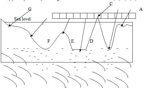
6. (a) Study carefully the diagram below and label letters A, B, C, D, E, F and G.
(b) Mention four factors which affect the temperature of the place.
(c) Change the following scale:
(i) 1: 50,000 into statement scale
(ii) One centimeter on the map represents two Kilometer on the ground. Change into (R.F) scale orFraction Scale.
(iii) Calculate the distance if the Map Scale is 1:50,000 and the distance obtained from point A to point B is 24 centimeter.
7. Carefully, study the climatic graph given and then answer the questions.
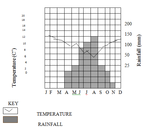
(i) Calculate the annual range of temperature
(ii) Calculate the annual rainfall for the stations
(iii) Calculate the mean annual rainfall for the station
(iv) Suggest the type of climate for the station.
(v) Give reasons for the suggestion you have given in (iv) above.
SECTION C (30 Marks)
Answer two (2) questions from this section.
- Outline the importance of studying geography
- Briefly explain the reasons why the earth is round
- What are the factors that affect the climate of a place
- Discuss the effects of rotation and revolution of the earth.
FORM ONE GEOGRAPHY EXAM SERIES 32
FORM ONE GEOGRAPHY EXAM SERIES 32

DOWNLOAD LEARNING HUB APP NOW

SORRY, YOU CAN'T VIEW THIS MARKING SCHEME PLEASE DOWNLOAD LEARNING HUB APP FROM PLAYSTORE TO GET FULL ACCESS TO ALL MARKING SCHEME!!
Click Here To Download Learning Hub Tanzania App
SAMAHANI, HUWEZI KUFUNGUA MAJIBU YA MTIHANI, TAFADHALI PAKUA APP YA LEARNING HUB TANZANIA ILI KUWEZA KUFUNGUA MAJIBU YA MITIHANI KATIKA TOVUTI HII!!
Bofya Hapa Kupakua App Ya Learning Hub Tanzania
Hub App
 For Call,Sms&WhatsApp: 255769929722 / 255754805256
For Call,Sms&WhatsApp: 255769929722 / 255754805256  MATOKEO KIDATO CHA IV 2023
FORM ONE SELECTION 2024
Matokeo Darasa VII 2023
SECONDARY REGIONAL EXAMS
PRIMARY REGIONAL EXAMS
FORM VI NECTA REVIEWS
FORM IV NECTA REVIEWS
FORM II NECTA REVIEWS
STD VII NECTA REVIEWS
STD IV NECTA REVIEWS
SECONDARY EXAMS SERIES
PRIMARY EXAMS SERIES
PRIMARY SUBJECT NOTES
SECONDARY SUBJECT NOTES
SECONDARY TOPICAL EXAMS
SECONDARY TOPICAL QUESTIONS
PRIMARY TOPICAL QUESTIONS
PRACTICAL EXAMS & NOTES
SECONDARY REGIONAL EXAMS
DOWNLOAD SUBJECT NOTES
SCHEMES OF WORK (PRIMARY & SECONDARY)
LESSON PLAN
SECONDARY LOG BOOKS
PRIMARY LOG BOOKS
LITERARY WORKS / UCHAMBUZI VITABU
METHALI ZOTE ZA KISWAHILI
Vitendawili Vya Kiswahili
FORM VI RESULTS 2023
FORM FIVE SELECTION 2023
Matokeo KIDATO CHA II 2022
Matokeo Darasa IV 2022
MATOKEO KIDATO CHA IV 2023
FORM ONE SELECTION 2024
Matokeo Darasa VII 2023
SECONDARY REGIONAL EXAMS
PRIMARY REGIONAL EXAMS
FORM VI NECTA REVIEWS
FORM IV NECTA REVIEWS
FORM II NECTA REVIEWS
STD VII NECTA REVIEWS
STD IV NECTA REVIEWS
SECONDARY EXAMS SERIES
PRIMARY EXAMS SERIES
PRIMARY SUBJECT NOTES
SECONDARY SUBJECT NOTES
SECONDARY TOPICAL EXAMS
SECONDARY TOPICAL QUESTIONS
PRIMARY TOPICAL QUESTIONS
PRACTICAL EXAMS & NOTES
SECONDARY REGIONAL EXAMS
DOWNLOAD SUBJECT NOTES
SCHEMES OF WORK (PRIMARY & SECONDARY)
LESSON PLAN
SECONDARY LOG BOOKS
PRIMARY LOG BOOKS
LITERARY WORKS / UCHAMBUZI VITABU
METHALI ZOTE ZA KISWAHILI
Vitendawili Vya Kiswahili
FORM VI RESULTS 2023
FORM FIVE SELECTION 2023
Matokeo KIDATO CHA II 2022
Matokeo Darasa IV 2022


